| Great Lakes Ecosystems | ||
|
||||||||||
|
1994
Proceedings
|
|
WHY SAVANNA CLASSIFICATION MATTERS:THE IMPLICATIONS
FOR LAND MANAGEMENT PLANNING,REVIEW AND IMPLEMENTATION
Randy R. Heidorn
|
 |
The conservation of biodiversity is often divided into 3 operational and ordered steps: identification, protection and management. Data collected and decisions made at each step can influence decisions and strategies in subsequent steps. The classification of a natural area as a forest, woodland, savanna or prairie implies an ambient community structure and composition. In order to maintain the full compliment of biodiversity at the species and community levels, management prescriptions are tailored to maintain or enhance the structure and composition. These management prescriptions may include removal of exotics, prescribed burning, or selective removal of native woody vegetation. The degree of each treatment is determined by the management goals for the natural area being managed. In Illinois, a manager typically uses the Public Land Survey notes to determine the condition of the land prior to settlement. Supplemental information may be obtained by viewing historic aerial photos of a site available through the national archives. If current conditions differ from the presettlement conditions, the manager needs to decide if current community types are to be maintained.
The following case studies demonstrate how classification impacts management prescriptions. For the purpose of this paper, I will use the criteria of Chapman (1990) to differentiate between community types. This classification considers a community a prairie if it has less than 5 percent woody canopy closure, savanna if it has 5 to 30 percent canopy closure, woodland if it has 30 to 80 percent closure and forest if it has greater than 80 percent closure. The sites discussed in the case studies are Illinois Natural Areas Inventory (INAI) natural areas which are protected as Illinois Nature Preserves. Quantitative data on the preserves were obtained from INAI data sheets archived by the Illinois Department of Conservation and includes data on tree density, basal area and dominance, seedling and sapling density, and herbaceous plant frequency (in prairies). The methods used for collecting this information are documented in White (1978).
Robinson Park Hill Prairies Nature Preserve, Peoria County, is owned and managed by the Peoria Park District. The INAI recognized this site as containing high quality glacial drift hill prairie. Prairie dominants include little bluestem (Schizachyrium scoparium) and big blue stem (Andropogon gerardi). These ridge top prairie remnants are surrounded by degraded dry-mesic upland forest, dominated by white oak (Quercus alba), northern red oak (Q. rubra) and shagbark hickory (Carya ovata) (Meyer 1987). Management activities within Robinson Park Hill Prairies Nature Preserve are directed at maintaining, enhancing and enlarging the prairie remnants through cutting and burning (Personal Communication, Mike Miller, 1994). It is reasonable to assume that fires which occurred within the hill prairies continued into the surrounding woody vegetation until they reached moist slopes on the sides of the hills and in ravines. Photographic evidence of the historic existence of larger prairies and the current presence of small degraded remnant prairies interspersed among higher quality remnants suggests the use of cutting and fire to restore presettlement conditions.
The decision on the extent to which fire and cutting are used on woodland and forest communities is much more difficult to make than with prairie communities. Forest Park and Detweiller Park Nature Preserves, both owned and managed by the Peoria Park District were all classified by the INAI as mesic or dry-mesic upland forest (Illinois Department of Conservation 1994). These communities would be classified as forest under Chapman's classification. However, within the matrix of high quality forest communities are degraded open woodland areas (Hutchison 1984). At Detweiller Woods some of these open areas contain prairie plants. Public Land Survey surveyors in 1817 described the river bluffs of Forest Park as well timbered and bluff top areas having barrens with small oaks and hickories (Hutchison 1984) suggesting the open aspect was more common during presettlement. Quantitative stand data collected by the INAI in 1977 shows that sugar maple (Acer saccharum) is increasing as northern red oak and white oak oak reproduction is decreasing within these preserves (Fig. 1).
For the manager, questions of if and how much burning is appropriate in woodlands are dependent on 1) whether succession has proceeded beyond the point where the open aspect of woodland, or savanna community can be restored and 2) the potential loss of native biodiversity currently present in the forest. Current plans in these preserves call for the liberal use of prescribed burning throughout the preserve and the use of cutting near the ridge top and prairie remnants. The goal behind this approach is to monitor the impacts of fire in promoting oak reproduction and restore the open woodland aspect in areas where they historically occurred (Personal Communication, Mike Miller, 1994). This approach assumes that maple are a natural part of the woodland/forest matrix and will be maintained as such. Recruitment of maples will be reduced by the fire and over time be limited to those unburned areas (i.e., north facing moist slopes).
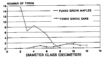
Portions of the interior of Funks Grove, McLean County, owned and managed by the Illinois Department of Conservation, also were described as mesic upland forest (Illinois Department of Conservation 1994). Like the above Peoria County preserves, the INAI data suggest the ultimate loss of oak to sugar maple (Fig. 2). However, unlike the others, oak is absent from size classes less than 40 cm in diameter indicating a long period of time without oak reproduction. This forest has succeeded to a community with little potential for return to a woodland due to the advanced stage of succession. Restoration to woodland or savanna by extensive removal of old growth maples would likely be politically impractical and destructive to the native biodiversity currently extant in this forest. The current management plans for this community will emphasize protection of the integrity of the forest community by controlling exotic plant species (Szafoni 1993).
When comparing current communities to presettlement communities, managers may be faced with a decision on which community should be targeted for restoration. In the four preserves described above, existing community classification was the dominant factor in determining long term management goals and the restoration methods to be employed within the target community. The application of quantitative community data was integral to establishing the technical feasibility for achieving these goals. These goals then determined appropriate levels and methods of native brush and tree control, and prescribed burn frequency, intensity, and timing.
Classification of the ambient condition is important if it is based on quantitative data. Although Chapman's (1990) classification system was employed for the purpose of discussion, other classification systems could have been employed. The quantitative data underlying any classification system is the important factor used to determine management goals and plans.
I would like to thank Dr. Brian Anderson for his helpful suggestions in the preparation of this presentation. I also would like to express my appreciation to the Illinois Department of Conservation, Division of Natural Heritage for archiving and maintaining the Illinois Natural Areas Inventory files.
Chapman, K. 1990. Crosswalk Classification of Terrestrial and Palustrine Community Types. Unpublished report. Midwest Office of the Nature Conservancy, Minneapolis. Cited in Packard, S. 1993 Restoring Oak Ecosystems. Restoration and Management Notes. 11(1):5-16.
Hutchison, M. 1984. Master plan for Forest Park Nature Preserve, Forest Park Foundation, Peoria County, Illinois. 2nd Edition. Unapproved Draft Plan prepared for the Illinois Nature Preserves Commission, Springfield.
Illinois Department of Conservation. 1994. Biological Conservation Data-Base. Illinois Department of Conservation. Division of Natural Heritage, Springfield, IL.
Meyer, L. S. 1987. A proposal to the Peoria Park District for dedication of Detweiller Woods, Forest Park South, and Robinson Park Hill Prairies, all in Peoria County, Illinois as Illinois Nature Preserves. Illinois Nature Preserve Commission, Springfield.
Szafoni, R. 1993. Management Schedule for an Illinois Nature Preserve: Funks Grove Nature Preserve. Illinois Nature Preserves Commission, Springfield. (Unpublished)
White, J. 1978. Illinois Natural Areas Inventory Technical Report: Volume 1 Survey Methods and Results. Illinois Natural Areas Inventory, Urbana.
Figure 1. The distribution of oak and sugar maple stems by age class within Forest Park Nature Preserve and Detweiller Park Nature Preserve, Peoria County, Illinois. Data are from the Illinois Natural Area Inventory field data and are based on 20 - 0.025 ha plots/preserve.
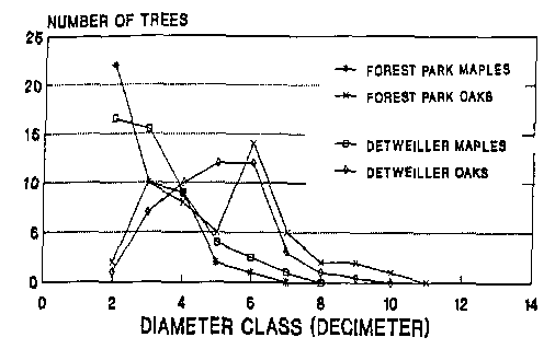
Figure 2. The distribution of oak and sugar maple stems by age class within interior portions of funks Grove Nature Preserve, McLean County, Illinois. Data are from the Illinois Natural Area Inventory field data and are based on 20 - 0.025 ha plots/preserve.