| Great Lakes Ecosystems | ||
|
||||||||||
|
1994
Proceedings
| ||||||||||||||||||||||||||||||||||||||||||||||||||||||
|
THE BIG BARRENS REGION OF KENTUCKY AND TENNESSEE:
A SHORT REVIEW Jerry M. Baskin Edward W. Chester |
 |
Information presented in this paper, for the most part, is a summary of three review articles previously published by the authors (Baskin and Baskin 1981; Chester 1988; Baskin et al. 1994). References to all items discussed below are cited in one or more of these reviews. The objectives of our field and literature research were to:1) describe the physical environment and vegetation of the Big Barrens Region; 2) briefly survey the historical and pre-historical evidence for existence of barrens in the Big Barrens Region before settlement by Europeans, i.e., before ca. 1780; 3) determine if the barrens of the Big Barrens Region should be considered part of the Prairie Peninsula; and 4) develop a list of characteristics to distinguish between cedar (limestone) glades, xeric limestone prairies, and barrens.
The Big Barrens Region nearly is coincident with the Pennyroyal Plain and Elizabethtown Plain subsections of the Highland Rim Section of the Interior Low Plateaus Physiographic Province (Fig. 1). In this paper, these two sub-sections will be referred to collectively as the Kentucky Karst Plain (KKP).
The KKP is a level to steeply rolling karst (sinkhole) plain. Elevations range from about 150 to 300 m asl, but most of the KKP is 150 to 200 m asl. Sinkholes are numerous in certain areas of the Karst Plain and absent in others; some of them contain permanent lakes or ponds. Several meters of soil, eroded from agricultural fields, have been deposited in most of the sinkholes. Upland flats and depressions are distinctive features of the KKP; many of them have been drained for agricultural purposes. There are numerous sinking streams on the KKP, and surface streams are absent in highly karstic areas. The KKP is drained by the Barren, Green, Little, Nolin, and Red rivers and other streams. Near its boundary with the Shawnee Hills, the landscape of the KKP consists of many ridges and knobs, some of which rise 100 m or more above the Karst Plain.
Bedrocks for most of the KKP are the St. Louis limestone and Ste. Genevieve formation (Upper Mississippian, Meramecian Series). Rocks older [e.g., Ft. Payne formation, (Lower Mississippian, Osagean Series)] or younger [e.g., Girkin formation (Upper Mississippian, Chesterian Series)] than the St. Louis and Ste. Genevieve may be the bedrock of the KKP near its boundaries with other physiographic regions. The highest knobs are capped with the Big Cliffy Sandstone (Chesterian).
Soils of the KKP generally can be divided into three broad categories: 1) deep, moderately- to well-drained soils on level to steeply rolling uplands; 2) deep, well-to poorly-drained soils on floodplains, upland flats, and depressions; and 3) shallow to moderately deep, well-drained soils on ridges, knobs, benches, and level to rolling parts of the Karst Plain proper. Soils in Category 3 often are associated with limestone rock outcrops. Parent materials for these Alfisols and Ultisols include loess, residuum weathered from high grade and cherty limestones, sandstone (on tops of the highest knobs and ridges), and old and recent alluvium.
Barrens occur primarily on the deep limestone-derived soils of Category 1, but some are on Colbert and Talbot soils (Category 3). The Crider-Pembroke and Pembroke-Crider are the moist important soil associations on the KKP. Major soil series on uplands in addition to Crider and Pembroke include the Baxter, Dickson, and Nicholson. The Baxter, Crider, and Pembroke are well-drained, while the Dickson and Nicholson are moderately well-drained. These soils are on level to moderately steep sloping uplands, where depth to bedrock is >1.5 m. The two most typical soils of upland flats and depressions (Category 2) are Robertsville in Kentucky and Guthrie in Tennessee.
Typical soils in category 3 include the Colbert, Fredonia, Talbot, and Caneyville series, which may occur in association with enough rock outcrops to make up soil-rock outcrop complexes. The few typical cedar glades on the KKP are in Kentucky on the Fredonia rocky silt loam, 2 to 12 percent slopes; Fredonia-Rock outcrop complex, 6 to 20 percent slopes; and Rock outcrop-Fredonia-Colbert complex soil mapping units. Important soils of xeric limestone prairies, including those on parts of the Knobstone Escarpment and Shawnee Hills (SH) adjacent to the KKP, and those on the sides of knobs and ridges in the "transition zone" between the KKP and SH, are the Caneyville, Fredonia, Garmon, Hagerstown, and Talbot.
According to the system of Thornthwaite, the KKP has a humid meso-thermal climate with an adequate amount of water for plant growth during all seasons of the year (BB'r). In the Kîppen system, it has a mild temperate rainy climate without a distinct dry season and with a hot summer (Cfa). The climate of the KKP falls into Borchert's region II (rainy winter, but summer and winter rainfall about equal; sunnier in summer than in winter). In these three classification systems, the Midwestern Tallgrass Prairie Region is in a different climatic zone than the Big Barrens Region. An important difference in the climate of the two regions is that summer droughts are more severe in the Midwest, due to the stronger influence of the dry westerlies.
The KKP is in the Western Mesophytic Forest Region of Braun, and the Oak-Hickory Forest/Bluestem Prairie Region of Kuchler. Thus, according to Kuchler, the potential natural vegetation of the Big Barrens Region is the same as that of the Midwest Prairie Region. Most maps of the Tallgrass Prairie published after Transeau's 1935 paper include the barrens of the Big Barrens Region as part of the Prairie Peninsula. An exception to this is a map of the Tallgrass Prairie by Kucera published in 1992.
The landscape of the KKP is diverse, and thus it supports a wide spectrum of natural or semi-natural plant community types, including limestone cedar glades, xeric limestone prairies, barrens, forests of dry, mesic, and wetland sites, aquatic vegetation of sinkhole lakes and ponds, farm woodlots, old fields, pastures in various stages of secondary succession, and various types of ruderal sites. However, most of the KKP now is an agricultural landscape, and nearly all of the remaining natural vegetation has been moderately to highly disturbed. Tobacco, corn, soybeans, winter wheat, hay, cattle and hogs are the important agricultural products of the region.
Writings of people who saw the area in the late eighteenth and early nineteenth centuries indicate that before settlement by Europeans, much of the KKP was a grassland with forbs and shrubs interspersed with stunted oaks and hickories, i.e., barrens. Additionally, the earliest maps of Kentucky, published by Filson in 1784 and Munsell in 1795, show extensive areas of barrens on the KKP. No General Land Office (GLO) Survey was made of the KKP. However, GLO surveys conducted on the Mitchell Plain in southern Indiana in 1804-1807 recorded extensive areas of barrens on this karstic landscape just north of the Elizabethtown Plain.
Although several theories have been presented on the origin of barrens in the Big Barrens Region, the one with the strongest support is that these grasslands came into existence as a result of clearing of forest by Native Americans. Evidence from anthropological and paleoecological (pollen diagrams) studies suggest that barrens on the KKP may have come into existence as early as 3,000 to 4,000 YBP.
For the following reasons, we have concluded that the barrens of the KKP should not be included in the Prairie Peninsula. (1) Paleoecological studies show that whereas the Midwestern Prairies came into existence early in the Hypsithermal Interval, grasslands were not present on the KKP until after the Hypsithermal. (2) Soils on the KKP were developed under forests, whereas those of prairies in the Midwest formed under grasslands. (3) At least six plant taxa endemic, or nearly so, to the Midwestern Prairies (e.g. Asclepias meadii Torr. and Lespedeza leptostachya Engelm.) do not occur in the Big Barrens Region. Further, the eastern portion of the ranges of several Tallgrass Prairie plants (e.g. Amorpha canescens Pursh and Coreopsis palmata Nutt.) and animals [e.g., ornate box turtle Terrapene ornata Agassiz and Franklin's ground squirrel, Spermophilus franklinii (Sabine)] coincide closely with the Midwestern Tallgrass Prairie Region; thus, none of these occurs in the Big Barrens Region or anywhere else in the Southeast. (4) From historical accounts, we know that upon cessation of burning by Native Americans forests replaced barrens on the KKP. (5) Climate on the KKP from the early Holocene to present has been more favorable for the origin and maintenance of forest than grassland; it has been more favorable for prairie in the Midwest than in the Big Barrens Region. (6) The climax vegetation for the Big Barrens Region is deciduous forests, and after abandonment of agricultural and other human-disturbed lands succession is to forest.
In eastern North America, considerable disagreement exists over the use of the terms cedar (limestone) glade, xeric (limestone) prairie, and barren. For example, plant communities on shallow, rocky limestone soils dominated by Little bluestem [Schizachyrium scoparium (Michx.) Nash] have been called cedar (or limestone) glades, barrens, and xeric or limestone prairies. To help resolve this problem, we developed a list of characteristics for use in distinguishing these three types of communities (Table 1).
The term "cedar glade" has been used for many years in the southeastern United States for edaphic climax plant communities on shallow, rocky limestone soils dominated by annual or perennial forbs, annual grasses, cryptogams, or some combination of these. The concept of cedar glades first was given a sound quantitative basis by Elsie Quarterman in the 1940's in her studies of the limestone rock outcrop plant communities in the Central Basin of Tennessee. Quarterman recognized two types of open glades ("grassy" and "gravelly"), and in both types Sporobolus vaginiflorus (Torrey ex Gray) Wood, a drought-tolerant, Csummer annual grass, was the dominant plant species. Neither little bluestem nor other perennial grasses was an important component of the vegetation. In his extensive studies of herb-dominated vegetation in southeastern USA, Hal DeSelm also uses "cedar glades" only for plant communities in which perennial grasses are relatively unimportant.
In the Ozarks and Midwest, on the other hand, "cedar glades" has been used for plant communities dominated by Little bluestem and/or other perennial grasses on rocky (limestone or dolomite) soil. On Kuchler's map, the potential natural vegetation of the glade region of the Missouri Ozarks is the same as that of middle Tennessee-northern Alabama. However, most of the sites previously called cedar glades in these two regions clearly do not fit the "Middle Tennessee Cedar (Limestone) Glade Concept." There certainly are enough differences in structure, species composition, and successional relationships of the so-called glades of the Midwest-Ozarks and those of middle Tennessee to recognize them as distinct vegetation types. Thus, we suggest that these rocky, prairie grass-dominated communities of the Ozarks and Midwest be called xeric limestone prairies. Use of "xeric limestone prairies" for the so-called cedar glades of the Ozarks and Midwest would be consistent with its use by Roland Harper in 1920 and by E. L. Braun in the 1928 in Alabama and unglaciated southern Ohio, respectively.
The barrens on the KKP referred to by early travelers and those occurring in this Region today were (are): 1) on deep soils developed under forest vegetation, 2) anthropogenically-derived and maintained, and 3) dominated by prairie grasses, primarily Little bluestem (Table 1). Since Filson used the term "barrens" for this type of vegetation in his description of the geography of Kentucky in 1784, we suggest that it continue to be applied to such communities. If the term "barrens" is used in the description of other communities, it should be preceded by a word(s) indicating the type of barrens, e.g., cedar barrens or post-oak barrens.
The best examples of barrens in the Big Barrens Region today are on the Fort Campbell Military Reservation (FCMR), on the southwestern part of the KKP. These barrens: 1) are on land that was used to grow cultivated crops prior to establishment of the FCMR in 1942, 2) occur primarily on Dickson silt loam, 1 to 4 percent slope, a soil developed under forests, 3) are maintained by intentional and unintentional burning by the military, 4) have a flora consisting primarily of common and geographically widespread species of grasses and forbs; and 5) are dominated by Little bluestem.
Baskin, J. M. and C. C. Baskin. 1981. The Big Barrens of Kentucky not part of Transeau's Prairie Peninsula. In R. L. Stuckey and K. J. Reese, eds. The Prairie Peninsula - in the "shadow" of Transeau. Proceedings of the Sixth North American Prairie Conference, The Ohio State University, Columbus. Ohio Biological Survey Biological Notes Number 15:43-48.
Baskin, J. M., C. C. Baskin and E. W. Chester. 1994. The Big Barrens Region of Kentucky and Tennessee: Further observations and considerations. Castanea. In press.
Chester, E. W. 1988. The Kentucky prairie barrens of northwest middle Tennessee: An historical and floristic perspective. In D. H. Snyder, ed. Proceedings of the First Annual Symposium on the Natural History of Lower Tennessee and Cumberland River Valleys. P. 145-163. The Center for Field Biology. Austin Peay State University, Clarksville, Tennessee.
Table 1. Some characteristics of cedar glades, xeric limestone prairies, and barrens.
Community Type |
|||
| Community Characteristic | Cedar Glade | Xeric Limestone Prairie | Barrens |
| Slope | Nearly flat | Gently rolling to steep | Flat to moderately steep |
| Soil Depth to Bedrock | Shallow; 0.0 -2.5 m | Shallow to moderately deep; 0.0-1.0 m | Deep; >1.5 (0.5-12) m |
| Exposed Rock | Pavement, gravel & flagstone | Gravel & flagstone ledges | None1 |
| Dominant Graminoids | Native C4 annual grasses |
Native C4 perennial grasses |
Native C4 perennial grasses |
| Primary Forbs
|
Native C3 winter annuals, summer annuals & perennials |
Native C3 perennials;A few C3 summer annuals |
Native C3 perennials |
| Endemic Plant Taxa | Yes | No | No |
| Stability | High | Moderately high | Low |
| Origin | Natural; edaphic climax | Anthropogenic; disclimax | Anthropogenic; a stage in secondary succession |
| Management Needs | None | Occasional | Frequent |
1 Some rock may be exposed in barrens where soil is < 1.0 m in depth.
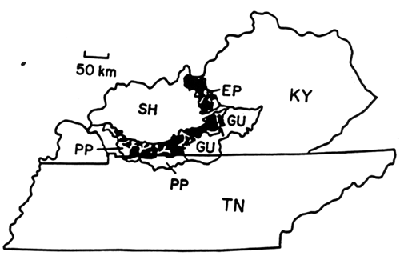
Figure 1. Historical occurrence of barrens (black) in the Big Barrens Region (Kentucky Karst Plain) of Kentucky and Tennessee. EP = Elizabethtown Plain, GU = Greensburg Upland, PP = Pennyroyal Plain, and SH = Shawnee Hills. The northwestern part of the Knobstone Escarpment, on which xeric limestone prairies occur, is just east of the EP.