| Great Lakes Ecosystems | ||
|
||||||||||
|
1994
Proceedings
|
|
VEGETATION SURVEY OF A QUARTZITE GLADE IN SAUK
COUNTY, WISCONSIN
Patricia K. Armstrong, Ecologist/Consultant |
 |
Glades are special plant communities similar to barrens or savannas where the bedrock is close to the surface. White and Madany (1978) define a glade as "...an opening in the forest, caused by bedrock at or near the surface and (usually) a steep southern or western exposure. A glade is usually a mosaic of stunted trees, shrubs, patches of herbaceous vegetation, and open areas with little or no vegetation." Nelson's (1985) definition is similar: "Glades are rocky barrens dominated by a herbaceous flora with sparse woody vegetation.... Soil depth is very shallow, ranging from zero to 15 inches deep and interspersed with copious rock fragments." According to Heikens (1991), glades, have mostly less than 10% cover in prairie species, less than 50% cover in woody plants, less than 10 cm soil, and often more than 10% exposed rock. They differ from barrens which have more than 10% cover in prairie species, less that 50% cover in woody plants, a soil depth of 10-40 cm, and 1-5% exposed rock.
Midwestern states south of glaciation have many different types of glades which have been studied by various investigators: Midwest (Hutchison 1993), Indiana (Bacone, et al. 1983, 1984), Illinois (Heikens 1991) and (Hutchison, et al. 1986), Missouri (Nelson and Ladd 1983), (Nelson 1985), Kentucky and Tennessee (Baskin and Baskin 1978, 1985, 1986, 1988, 1989; Baskin et al. 1968) and (Quarterman 1948, 1950a, 1950b, 1989).
The limestone glades of Kentucky and Tennessee have been the most intensively studied (Baskin and Baskin 1968, 1989); Delcourt et al. 1986; Harper 1926; Mahr and Mathis 1981; Somers et al. 1986).
Limestone glades in Illinois were studied by Ozment (1967), Mohlenbrock and Voigt (1965) and Kurz (1981) and in Indiana by Aldrich et al. (1982).
Sandstone glades in Arkansas were studied by Jeffries (1985, 1987), in Louisiana by MacRoberts and MacRoberts (1992), in Illinois by Mohlenbrock (1954), Winterringer (1949) and Winterringer and Vestal (1956).
Granite glades have been studied in a number of states: (McVaugh 1943), North Carolina (Wyatt and Fowler 1977), Alabama (Harper 1939), Georgia (Burbanck and Platt 1964), Texas (Whitehouse 1933), and Minnesota (Nietering 1984). Diabase glades were studied in North Carolina (LeGrand 1988) and acid bedrock glades in Wisconsin (Clark 1993).
Although few of the glades studied share the same species of plants due to widely different edaphic conditions and latitude, all glades exhibit some common characteristics:1) steep south or westerly exposures, 2) shallow soil 0-40 cm, 3) exposed rocks, often more than 10%, 4) dwarfed or twisted trees, 5) extended periods of seasonal drought, 6) presence of woody shrubs and grassy, 7) high cover of mosses and lichens, 8) open, sunny breaks in the canopy and 9) a high degree of endemism made up of species that compete very poorly in the richer, shaded forests surrounding the glades.
The purpose of this study was to examine an acid quartzite bedrock glade to determine the vegetation and rank it according to the coefficient of conservatism (cc) system developed by Swink and Wilhelm (1979). Specifically, Of interest were endemic or rare and endangered species and if the glade was worthy of preservation.
The glade is located in the Baraboo Hills which stretch across Sauk and Columbia Counties for 25 miles. The Hills rise 500 feet above the surrounding countryside, and are forested, for the most part, with deciduous trees although Juniperus, Pinus, Taxus, and Tsuga occur on the bluffs and in deeply cut stream gorges. Hill prairies and pygmy forests occur as breaks in the canopy on more exposed south and west facing slopes and some of these are now classified as Acid Bedrock Glades (Epstein 1991). The shallow soil is developed in loess and classed as Baraboo Stony Silt Loam (USDA 1977).
The area is unique in several ways. It lies in the driftless areas of south-central Wisconsin which is farther north than most glades that have been studied, and it is situated on quartzite bedrock, an acid rock type much less common than limestone, sandstone or granite.
Nineteen 8 meter diameter (50 m2) plots were established on a southwest facing quartzite glade in Sauk County, Wisconsin. Plant surveys were conducted in May and September of 1992 to determine the species present and the percent cover. Seven size classes were used: 1 = 0-1% cover, 2 = 1-7% cover, 3 = 7-25% cover, 4 = 25-50% cover, 5 = 50-75% cover, 6 = 75-93% cover, 7 = 93-100% cover
All trees greater than 5 cm basal circumference were measured and counted as trees. Stems less than 4 cm in circumference and all shrubs as well as herbaceous plants were sampled for presence and percent cover. The angle and direction of slope was recorded for each plot, and four soil depths (one in the center and three at random) were taken within each plot.
Understory/herb data were summarized and analyzed using the natural area-native rating index system developed at the Morton Arboretum by Swink and Wilhelm (1979). Tree data were summarized and analyzed following the procedure of Wilhelm (1991).
Slope varied from 14 to 34 % with the average of 22 %. Six plots faced south with an average slope of 20 %, ten plots faced southwest with an average slope of 25 %, and two plots faced west with an average slope of 21 %.
Soil depth ranged from exposed bedrock (0.0 cm) to more than 16 cm with the average depth of about 8.5 cm.
The percent of ground covered by rock in each plot varied from 0.0 % to as high as 56%. In fact, rock outcrops (listed as soil in Table 2) occurred in all 19 plots and had the third highest relative importance value. Plots with the least amount of rock were dominated by a grassy turf made up of Carex pensylvanica, Danthonia spicata, and Poa pratensis with Dodecatheon meadia and Antenaria plantignifolia as co-dominants. Rosa carolina also was common. Bare soil and mosses were not present.
In plots with the highest amount of exposed rock, Carex pensylvanica, Danthonia spicata and Antenaria plantiginifolia were still the dominant plants but had much less cover. Vaccinium angustifolium and Gaylussacia baccata were the common shrubs. Bare soil and mossy areas with Leucobryum glaucum and several species of Polytrichum moss and Cladonia lichens covered as much as 84% of some plots.
Ninety four trees more than 5 cm basal circumference were encountered in the study; 20 of the 94 trees were dead. The number of trees per plot ranged from 0 to 11 with six plots having six trees. The average number of trees per plot was 5. White oak was the most common species (36) ranging from 33 to 170 cm basal circumference. They had the largest amount of trees greater than 100 cm (7) and the largest tree in the study, 170 cm. Black oak was the second most common tree species (22 plus 9 dead) ranging in size from 10 to 137 cm basal circumference. There were 10 red oaks ranging from 30 to 132 cm and 6 shag bark hickories from 41 to 84 cm basal circumference.
Computing the basal area of trees (See Table 1) gave white oak a relative importance value of 65.5 %, black oak 16.89 %, standing dead trees 12.9 %, red oak 3.8 % and shag bark hickory 1.0%. Of the smaller trees in the shrub class, black oak ranked 5th in over all importance occurring in all 19 plots, followed by red oak, ranking 10th in over all importance and occurring in 18 plots. Red oak ranked 11th and occurred in 15 plots. Shagbark hickory ranked 21st in over all importance and was present in 14 plots which was behind Amelanchier laevis, 12th in over all importance, occurring in 19 plots. (Table 2).
Although a study was not done in the surrounding forest, red oak and white oak were the dominant trees with the white oak in general being larger trees than the red oak. The biggest black oaks in the forest were near the edges of the bluffs and many of them were hollow and/or dead. This would seem to indicate that black oak is the first tree to enter these open areas followed by white oak with red oak being the third species to enter as the woods become more mesic. Shagbark hickories were not common in the surrounding woods.
Several investigators have suggested that glades often have a high proportion of shrubs. This would not seem to be the case in this study. Only two shrubs appear in the 20 most important species (Table 2). However, all three oaks and the shagbark hickory in shrub size rank in the top 20. The two most common shrubs in this study are Vaccinium angustifolium, 6th in importance, occurring in 16 plots and Amorpha canencens, 15th in importance, occurring in 15 plots.
The total number of plants per plot ranged from 20 to 46 with the average being 34 species per plot. Of the 109 species encountered in the study, only 4 were non-native species. Two of these were the blue grasses Poa compresa, 8th in importance, occurring in 17 plots, and Poa pratensis, 13th in importance, occurring in 16 plots. Less than 5 individuals of the other two exotics were seen.
Carex pensylvanica was the most important plant in the study occurring in all 19 plots with a coverage value of 79, followed by Antenaria plantiginifolia, ranked 2nd, present in all 19 plots with a coverage value of 75, and Danthonia spicata, 4th, 17 plots. Of the top 20 herbaceous plants (Table 2) 1 was a sedge, 3 were grasses, 8 were common prairie plants, and 2 were associated with oak woods (Solidago ulmifolia and Gerardia grandiflora). In comparing the species list with species lists of other glades, less than three percent of the plants were common to both lists; instead the majority of plants were the same as those occurring in Wisconsin prairies.
The mean rated quality of the 105 native species encountered in the study was 7.52 which is quite high, and the overall natural area quality rating was 75.67. According to Swink and Wilhelm (1989) "Areas which rate in the 50's and higher are of paramount importance; such areas are extremely rare, probably occupying less than 0.02 % of the total land area in the Chicago Region." Forbs made up 52.3 % of the species present, trees 13.8 %, grasses 11.9 %, shrubs 11 %, ferns 4.6 %, exotics 3.6%, vines 1.8 % and sedges 0.9 %. Although several rare and endangered species occur in Wisconsin Acid Bedrock Glades (Clark 1993), Lespedeza virginica (threatened in Wisconsin) was the only species encountered in this study.
Nevertheless, the almost total lack of alien species, the high quality of the native species, and the balance of the system with few strong dominants and many of more-or-less equal importance indicates the preservation value of this community.
Aldrich, J. R., J. A. Bacone and M. D. Hutchison. 1982. Limestone glades of Harrison County, Indiana. Proceedings Indiana Academy of Science 91:480-485.
Bacone, J. A., L. A. Casebere and M.D. Hutchison. 1983. Glades and barrens of Crawford and Perry Counties, Indiana. Proceedings Indiana Academy of Science 92:367-373.
Bacone, J. A., L. A. Casebere and M. D. Hutchison. 1984. Glades of the Knobstone Escarpment in Indiana. Proceedings IN Academy of Science 93:303-307.
Baskin, J. M., E. Quarterman and C. Caudle. 1968. Preliminary check-list of the herbaceous vascular plants of cedar glades. Journal of the TN Academy of Science XLIII:65-71.
Bridges, E. L. and S. L. Orzell. 1986. Distribution patterns of the non-endemic flora of middle Tennessee limestone glades. ASB Bulletin 34:155-166.
Burbanck, M. P. and R. B. Platt. 1964. Granite outcrop communities of the Piedmont Plateau in Georgia. Ecology 45:292-306.
Clark, F. 1993. A brief description of "Acid Rock Glade" communities in the Baraboo Hills, southeastern Wisconsin. Unpublished Report.
Delcourt, H. R., P. A. Delcourt, G. R. Wilkins and E. N. Smith Jr. 1986. Vegetation history of the cedar glades region of Tennessee, Kentucky, and Missouri during the past 30,000 years. ASB Bulletin 33:128-137.
Epstein, E. 1991. Natural Communities of Wisconsin, WI. Unpublished Report. Natural Heritage Program.
Harper, R. M. 1926. The cedar glades of mid Tennessee. Ecology 7:48-54.
Heikens, A. A. 1991. Classification of the Natural Forest Openings in Southern IL. Ph.D. Thesis. Southern Illinois University, Carbondale, IL.
Hutchison, M. D. 1993. The barrens of the Midwest: A historical perspective. Unpublished Report. The Nature Conservancy, Ullin, IL.
Jeffries, D. L. K. 1985. Analysis of the vegetation and soils of glades on Calico Rock Sandstone in northern Arkansas. Bulletin of the Torrey Botany Club 112:70-73.
Jeffries, D. L. 1987. Vegetational analysis of sandstone glades in Devil's Den State Park, Arkansas. Castanea 52:9-15.
Kurz, D. R. 1981. Flora of limestone glades in Illinois. In: Proceedings of the Sixth North American Prairie Conference. p.183-186.
LeGrand, H. 1988. Cedar glades on diabase outcrops: A newly described community type. Castanea 53:168-172.
MacRoberts, M. H. and B. R. MacRoberts. 1992. Floristics of a sandstone glade in western Louisiana. Phytologia 72:130-138.
Mahr, W. P. and P. M. Mathis. 1981. Foliose and fruticose lichens of the cedar glade flora in Stones River National Battlefield, TN. Journal of Tennessee Academy of Science 56:66-67.
McVaugh, R. 1943. Vegetation of granite flat-rocks, southeastern U.S. Ecological Monographs 13:119-166.
Mohlenbrock, R. H. 1954. The Vegetation of Giant City State Park: A Floristic and Ecological Study. M.S. Thesis, Southern Illinois University, Carbondale, IL.
Mohlenbrock, R. H. and J. W. Voigt. 1965. An annotated checklist of vascular plants of the Southern Illinois University Pine Hills Field Station and environs. Transactions of the IL State Academy of Science 58:268-301.
Nelson, P.W. 1985. The terrestrial natural communities of Missouri. Missouri Department of Natural Resources, Jefferson City, MO.
Nelson, P. and D. Ladd. 1983. Preliminary report on the identification, distribution and classification of Missouri glades. In: Proceedings of the Seventh North American Prairie Conference. p. 59-76.
Nietering, C. A. 1984. Floristic Survey of the Granite Outcrops of the MN River Valley. M.S. Thesis, University of Minnesota, Minneapolis.
Ozment, J. E. 1967. The vegetation of limestone ledges of southern Illinois. Transactions of the IL State Academy of Science 60:135-173.
Quarterman, E. 1948. Plant Communities of Cedar Glades in middle Tennessee. Ph.D. Thesis, Duke University, Durham, NC.
Somers, P., L. R. Smith, P. B. Hamel and E. L. Bridges. 1986. Preliminary analysis of plant communities and seasonal changes in cedar glades of mid Tennessee. ASB Bulletin 33:178-192.
Swink, F. and G. Wilhelm. 1979. Plants of the Chicago Region Revised and Expanded 3rd Edition, The Morton Arboretum, Lisle, IL.
USDA Soil Conservation Service. 1977. Soil Survey of Sauk County, WI.
White, J. 1984. Regional review of natural areas in the Shawnee National Forest with recommendations for protection and management. The Nature Conservancy, Arlington, VA.
White, J. and M. Madeny. 1978. Classification of natural communities in Illinois . In: Technical Report of the IL Natural Areas Inventory:309-405.
Whitehouse, E. 1933. Plant Succession on entral Texas granite. Ecology 14:391-405.
Wilhelm G. 1991. Implications of changes in floristic composition of the Morton Arboretum's East Woods. In. G. V. Burger, J. E> Ebinger, and G. Wilhelm, eds. Pages 31-54. Proceedings of the Oak Woods Management Workshop. Eastern Illinois University, Charleston.
Winterringer, G. S. 1949. Rock-Ledge Vegetation in Southern IL. Ph.D. Thesis, Univ. IL.
Winterringer, G. S. and A. G. Vestal. 1956. Rock ledge vegetation in southern Illinois. Ecological Monographs 26:105-130.
Wyatt, R. and N. Fowler. 1977. The vascular flora and vegetation of the North Carolina granite outcrops. Bulletin Torrey Botany Club 104:245-253
Table 1. Summary of species data for trees in a Wisconsin acid quartzite bedrock glade (1992 data).
|
Summary of Species |
Quercus alba |
Quercus velutina |
Quercus rubra |
Carva ovata |
Standing Dead |
Totals |
| Diameter Range (cm) | 11-50 | 4-44 | 10-42 | 13-27 | 6-35 | --- |
| Number of Plot Trees | 36 | 21 | 10 | 6 | 20 | 93 |
| Number of Trees/ha | 378 | 220 | 105 | 63 | 210 | 978 |
| Basal Stem / Basal Area (m2) |
2.18 |
0.96 |
0.46 |
0.20 |
0.78 |
4.58 |
| Basal Stem Basal Area (m2/ha) |
22.96 |
10.11 |
4.84 |
2.11 |
8.21 |
48.23 |
| Relative Importance Value* | 65.5 | 16.7 | 3.8 | 1.00 | 13.0 | 100.0 |
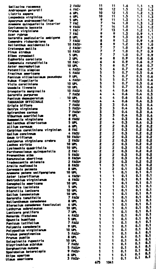
Table 2. Summary of data for understory plants in a Wisconsin acid quartzite bedrock glade (1992 data). Acronyms are: cc, coefficient of conservatism; FQ, frequency (%); COV, cover (%); RFQ, relative frequency; RCOV, relative cover; and RIV, relative importance value.