Contact EPA Pacific Southwest Water Division
Pacific Southwest, Region 9
Serving: Arizona, California, Hawaii, Nevada, Pacific Islands, Tribal Nations
Watershed Priorities
Morro Bay, California, Watershed
On this page:
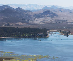
Copyright (C) 2002-2009 Kenneth & Gabrielle Adelman, California Coastal Records Project, www.Californiacoastline.org
Morro Bay, located between Santa Barbara and Monterey on California's Central Coast, is an important estuary, valued for its economic and ecological resources. The 2,300 acre estuary is home to a working fishing fleet and recreational boaters. Morro Bay provides important habitat for birds, fish and other animals. It is a vital stop for migrating birds on the Pacific Flyway. Sheltering pools and eelgrass beds provide nursery habitat for fish and invertebrates.
The Morro Bay National Estuary Program is one of 28 estuaries nationwide designated and funded by the US EPA as National Estuary Projects due to their national significance. The Morro Bay NEP protects and restores the important estuarine and watershed resources through on-the-ground projects, partnerships and education. The Morro Bay NEP and its partners monitor water and sediment quality, habitat and species. Monitoring is used to identify and track the most critical environmental issues, and to determine the effectiveness of restoration and pollution control actions.
Setting
The Morro Bay Watershed covers 76 square miles and includes two main tributaries: Chorro Creek and Los Osos Creek. The eight digit Hydrologic Unit Code (HUC) is 18060006. Land use includes about 60% ranchland, 19% brushland, 7% urban areas (City of Morro Bay, Los Osos and Baywood), 7% agriculture (crops) and 7% woodland. The Morro Bay Watershed climate is Mediterranean with the majority of precipitation occurring as rainfall in the winter.
Issues
Although the condition of the Morro Bay Watershed is relatively good when compared to other West Coast estuaries, and the resources are relatively intact, the watershed is none the less at great risk of degradation. Environmental issues of concern in the waters of the Morro Bay Watershed include:
- Increased sedimentation in the Bay and at the base of Chorro and Los Osos Creeks;
- Elevated amounts of pathogens;
- Elevated amounts of nutrients; and
- Reduced amounts of dissolved oxygen.
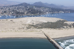
Copyright (C) 2002-2009 Kenneth & Gabrielle Adelman, California Coastal Records Project, www.Californiacoastline.org
In order to address these priority issues, the California Central Coast Regional Water Quality Control Board has developed, and the US Environmental Protection Agency has approved four Total Maximum Daily Load (TMDL) designations for the Morro Bay Watershed. These TMDLs are:
- Morro Bay Sediment TMDL, covering Chorro Creek, Los Osos Creek and the Morro bay Estuary (approved January 2004);
- Morro Bay Pathogen TMDL, covering Chorro Creek and Los Osos Creek, and the Morro Bay Estuary (January 2004);
- Chorro Creek Nutrients and Dissolved Oxygen TMDL (July 2007); and
- Los Osos Creek, Warden Creek and Warden Lake Wetland Nutrient TMDL (March 2005).
The US EPA works closely with the California’s Central Coast Regional Water Quality Control Board, the Morro Bay National Estuary Program and other watershed partners to protect and restore the water quality and ecosystem health of the Morro Bay watershed.
Resources
All links in this section exit EPA. ![]()
- Morro Bay National Estuary Program
- California Central Coast Regional Water Quality Control Board
- San Luis Obispo Science and Ecosystem Alliance
- Central Coast Wetlands GIS Project
Contact Information
Suzanne Marr (marr.suzanne@epa.gov)
(415) 972-3468