Bathymetric Surveys
What is Bathymetry?
Bathymetry is the measurement of the depths of water bodies from the water surface. It’s the marine equivalent to topography. Bathymetric surveys are generally conducted with a transducer which both transmits a sound pulse from the water surface (usually attached to a boat) and records that same signal when it bounces from the bottom of the water body. An echosounder attached to the transducer filters and records the travel time of the pulse. At the same time that the pulse occurs, a GPS unit can record the location of the reading. After many of these readings are taken, corrections are made based on fluctuations in the water surface elevation that may have occurred during the survey. The individual points are then mapped; easily done in a GIS.
Bathymetric surveys are used to characterize contaminated sediment sites for a number of reasons. The surveys record the sediment surface prior to remediation to assist in the remediation process. Surveys taken over time assist project managers in determining the transience of bottom sediments. This information can determine whether the contaminated sediment is stable or is susceptible to re-suspension. Surveys can also check on the efficiency of dredging operations.
FIELDS Use of Bathymetry
The FIELDS Team has been active in the generation of bathymetric profiles of contaminated sediment sites since 1996. Bathymetric surveys have been an integral part of many FIELDS assisted projects including Manistique Harbor, Pine River, Torch Lake, and Deer Lake.
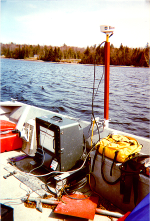
The FIELDS Team has utilized survey boats with either an over-the-side or hull mounted narrow beam (5 degree) transducer. The narrow beam averages over a smaller section of the bottom decreasing error. The echosounder used by the FIELDS Team is capable of industry-standard “bar check” calibration for high quality measurements of sound velocity and boat draft. In addition, a portable sound velocity unit was recently added to measure the water column in case of temperature stratification. GPS is provided by a sub-meter differentially corrected GPS unit mounted over the transducer. Coverage is assured using specialized survey software (Coastal Oceanographics’ HYPACK) which generates “planned lines” according to the accuracy needed. Water level corrections are obtained using either USGS gauges or a portable measuring device surveyed into location with survey grade GPS. To minimize the error caused by wave action, the FIELDS survey boat has been recently equipped with a heave/pitch/roll sensor which sends information to the survey software for signal correction.
Once data is collected and edited for obvious errors in the survey software, the soundings are converted to depth or elevation in either feet or meters and then exported to text files for import into GIS. Then, using the FIELDS Tools in ArcView, the points are interpolated in order to generate a surface map. If the file is very large (some files contain 40,000 points), the FIELDS Team may interpolate the data in Dynamic Graphics EarthVision software using EarthVision’s proprietary minimum tension gridding.