State Innovation Grants
EPA 2005-2006 State Innovation Grants Competition Pre-Proposals 1.0 Project Summary Information: State Innovation Grant
Project Title : Streamline Permitting Through Innovative Information Technology
Location: New Jersey Department of Environmental Protection
Applicant :
New Jersey Department of Environmental Protection
Office of Information Resources Management (OIRM)
Bureau of Geographic Information Systems (BGIS)
P.O. Box 428 , Trenton, New Jersey 08625
Project Contact Persons :
Sherry Driber
Chief Information Officer
NJDEP, OIRM
PO Box 428
Trenton , NJ 08625
Phone: 609-292-3211
Fax: 609-292-7900
Email: Sherry.Driber@dep.state.nj.us
Larry Thornton
Manager GIS
NJDEP, OIRM
PO Box 428
Trenton , NJ 08625
Phone: 609-633-8144
Fax: 609-292-7900
This project is not being executed in cooperation with or funded by any other Federal program. This project will be coordinated with other related efforts to increase potential for collaboration and reduce potential for redundancy. These efforts include, but are not limited to, Environmental Data Standard Council and Region V GeoSpatial Data Standard Development, EPA NEPAssist Region II Pilot, and Arizona’s online permitting GIS capability.
No Federal regulatory flexibility is needed to implement this project.
NJDEP Commissioner Bradley M. Campbell endorses this project.
2.0 Project Narrative
The purpose of this project is to develop a seamless systems oriented permitting assistance “Next Generation” process, leveraging existing NJDEP cross media enterprise data bases and applications (NJ Environmental Management System, DEP Online and iMapNJ) to measurably simplify permitting, while providing greater predictability and transparency to our constituents. NJDEP proposes to link GIS and iMap capabilities to its online permitting system to help applicants, project planners, consultants and other iMapNJ users to complete permit applications, answer questions regarding regulatory applicability, and submit geospatial maps to DEP. Users will be able to electronically complete and submit permit applications using DEP Online with innovative “smart” engines running in the background to launch, view and analyze GIS data, delineate on screen or download and resubmit geospatial data. This will provide applicants and DEP permit analysts with the requisite data on the desktop to electronically evaluate and complete permit applications, in some cases auto-generate permits.
The project’s capability will streamline permit application submittal and processing, result in more accurate application submittals, and provide for more effective permit review and processing. Where possible this capability will allow auto-generation of a permit, significantly reducing permit processing turn around time.
The approach will begin with a Land Use permit application, but the tools and functionality built as part of this project will be leveraged for all DEP online permits, all media. Lessons learned will be documented and shared throughout the process. Project milestones will be tracked, measured and reported. Permit applicant and DEP staff time and costs will be baselined and then measured using the new tools to show savings in both time and costs. NJDEP will investigate models used for Return of Investment (ROI) and will select one to calculate and report the ROI for this project.
This innovative project supports the goals of EPA’s Strategic Plan specifically in Land Preservation and Restoration, and Compliance and Environmental Stewardship, by requiring specific digital site information and geo-processing for proposed permits and by providing applicants with geo-spatial assessment tools and viewer on the web.
For the NJDEP, this grant application provides both an opportunity and challenge to bring permitting tools into the 21 st century with a bold strategy that simplifies, enhances and renders more predictable environmental decision-making in the environmental permitting venue.
Basis and Background
New Jersey is currently facing a critical crossroads in terms of both water and land use resources. As the most densely populated state in the nation, New Jersey can be defined as the quintessential bedroom community that supports two major out of state cities, and provides housing, shopping, recreation, and vacation for her 8.4 million residents (Census Bureau, 2002 estimate). But New Jersey is running out of the resources that have made the geography of New Jersey critical to the tri-state region: potable water and uses of lands.
Using NJDEP detailed digital land use land cover datasets (1986, 1995, 2002) it has been estimated that New Jersey may run out of developable land sometime around mid-century. The NJDEP makes hundreds of land use decisions each month for regulatory purposes and for land acquisition (open space). The rich water resources of the state are also being taxed. New Jersey has two large well-defined areas of critical source water protection areas in the south. Large intakes are severely limited by law in these areas. The legislature defined water resource conservation as a primary concern for the justification behind the Highlands Protection Area and Plan, passed and signed into law this past summer. This act limits activities in over 795,000 acres of New Jersey, about 16% of the entire state!
The NJDEP has been actively searching for opportunities to adjust to these critical concerns and to the advances in information technology that can assist with integrated cross media management, greater efficiencies and improved access to information in organizational environmental decision-making. In 1995, the NJDEP moved to integrate data in the large media programs and developed the New Jersey Environmental Management System (NJEMS). NJEMS serves as the day-to-day tool used by staff to track regulated entities, all regulated activities such as permits, inspections and enforcement action, as well as workflow. Building on NJEMS, DEP built DEP Online, to allow applicants to submit permits online where the data would be stored and tracked in NJEMS.
In early 1987, the NJDEP became one of the first sites in the nation for a dedicated Geographic Information Systems Bureau running ArcINFO. Since that time the GIS has evolved into a state of the art program that has fostered an integrated toolbox of spatial tools into the everyday business in the NJDEP. The flagship success has been Internet i_MapNJ series, an ArcIMS application that serves everyone (NJDEP, public, regulated community) with a browser based view and spatial query application delivered in a simple interface designed for the casual user. The application is data rich, serving the best of NJDEP GIS.
The NJDEP has piloted a new enterprise intranet ArcIMS application, iMapNJ ArcIntelligence (AI). AI presents interactive, customizable profiles for multiple programs within the NJDEP to everyone in the DEP through its intranet, DEPNET. Profiles serve the specific spatial and database analysis needs of programs in the NJDEP including Water Allocation, Water Assessment, Water Monitoring, Division of Watershed Management, the NJ Geological Survey. iMapNJ AI also has a bi-directional bridge from ArcIMS to Business Object’s Web Intelligence. This feature adds multiple database functions to iMapNJ AI. iMapNJ profiles can be generated for specific program issues or issues that cross program boundaries. The power of GIS and industry standard IT have merged together seamlessly into GIT, geographic information technology. This application, iMapNJ ArcIntelligence, debuted on the NJDEP Intranet in 2004. NJDEP is working to port iMapNJ ArcIntelligence to the Internet, rewritten to the new web services concept. Enterprise profiles will include functional engines from ArcGIS Server.
Project Goals
The NJDEP needs to build on its IT systems to measurably simplify permitting, while providing greater predictability and transparency to our constituents. NJDEP proposes to link GIS and iMap capabilities to its online permitting system to help applicants, project planners, consultants and other iMapNJ users to complete permit applications, answer questions regarding regulatory applicability, and submit geospatial maps to DEP. The following goals will be achieved:
1. Simplifying the flow of information to and from external customers and the NJDEP by employing browser based iMapNJ interactive Internet mapping tools that allow users to download images and shapefiles, edit and then resubmit or upload those images and shapefiles as attachments to permit requests and queries.
2. Ensuring data submission accuracy by implementing a tool to calculate area, similar to the measure tool, except area evaluated, proposed, or submitted, calculated in square feet.
3. Providing access to data by developing protocols for storing internet generated permit input (text, images, shapes) in NJEMS and linking documents to each other providing seamless storage and retrieval mechanisms both to DEP staff through NJEMS and for external users through DEPonline. Geospatial data archive capabilities will ensure older data could be retrieved even where newer data proved the older data outdated or inaccurate.
4. Providing better exchange of data by developing p rotocols and middleware tools (capture, export, clip and ship, email, etc.) to allow permit writers/analysts to communicate in text, image and shapefiles to supervisors, staff and customers regarding approvals, denials, negotiable items.
5. Answering questions regarding regulatory applicability by providing automated analysis of the data.
6. Implementing this capability for Land Use permits for this project, in a way that can be leveraged by all other media, all other NJDEP permit programs.
7. Including constituents (business & industry, builders & developers, environmental group leaders, EJ and community leaders and the general public) in the design and testing process to insure a valuable tool is developed.
Project Tasks and Performance Measures
Project Contracting and Application Design - The BGIS will identify a contractor capable of completing all tasks. Upon award, the BGIS will work with the contractor to identify individuals who have the expertise and experience to serve as members of an application development and scoping session for the project. The sessions will include BGIS, OIRM, NJDEP program staff, the contractor as moderator and for documentation purposes.
Deliverable: The contractor will deliver a comprehensive text document of the meetings, a summary document, and will then develop a scope of work from these documents, in consultation with the committee.
Application Development - The consultant, under the management of BGIS will develop the requisite flow and process to reach the stated goals and link to existing applications to complete the cycle for innovative and enhanced permitting. NJDEP architecture, software, hardware, and GUI technical specifications shall be followed. Requisite portions of NJEMS will be spatially enabled with ArcSDE.
Deliverable: GIS and iMapNJ tools linked to DEPonline for Land Use application.
Implementation and Testing - The contractor shall port all development to the OIRM DEV server in Trenton, New Jersey. The applications shall be inserted seamlessly to the DEV series of i-MapNJ3, Data Miner, DEPonline, and NJEMS.
The BGIS will coordinate with contractor assistance, the testing of the overall process and applications. An edit log will be tracked for the contractor and all bugs identified shall be corrected. The project will then receive preliminary approval.
Deliverable: A fully functional permit cycle in the Development) framework.
Implementation and Serve to Internet - The contractor will manage the delivery and integration of the applications and process into the NJDEP Production framework at NJDEP.
Deliverable: Fully functional permit cycle project into the Production framework. A final report, technical report, and admin tools for editing and updating the process and a description of how to port this cycle to other permit programs.
Measurements and Accountability - The contractor and BGIS will develop, as part of the conceptual model, means by which measurement of success is attained. Minimum measures include: successful implementation of the developed tools, linking to online permit, investigation of ROIs, selection and use, improved throughput of permits by time period (measured against a baseline for the prior year(s) in NJEMS), interviews with constituents, permit applicants and writers to determine the level of improved quantity of relevant information (data), and achievements in communications from which decisions are made, and how that improved data flow and communication improved environmental decision making.
Quarterly reports will be furnished to EPA over the course of the project. Quarterly Reports will document the progress towards the milestones, impediments and plans to resolve impediments, status of the finances, and an overall description of the project.
Deliverable: Proof of successful implementation. ROI report. Statistics on throughput. Perceived improvements (by interview) in environmental decision making with concrete examples. An independent evaluation of the successes and failures of the process. INET hits.
Innovation Transfer - By contract the NJDEP will own all non-copyrighted middleware, processes, protocols, intellectual developments, text, images and shapes developed for the project and will make available all information considered non-proprietary or secure. These items include the conceptual models, protocols and flows.
Deliverable: A final report furnished to EPA.
Project Schedule and Timeframe
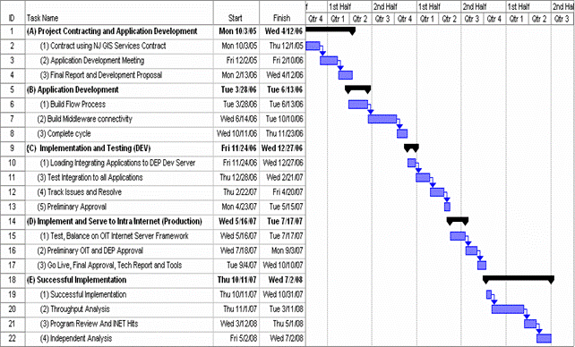 The NJDEP proposes that start date be October 2005 and will be completed by July 2008 . The major milestones are indicated in the following table:
Proposal Budget Summary
State: New Jersey
Agency: Department of Environmental Protection
Project Title: Streamline Permitting Through Innovative Information Technology
[Budgetary information removed by EPA]
Summary
New Jersey faces difficult decisions regarding critical water resources and the land uses of the remaining developable lands in the state. The NJDEP needs new technologies to deliver more information to its constituents, provide greater predictability and transparency in its actions, streamline its processes to make better use of its resources and use data to make better environmental decisions. This proposal addresses an innovative, next generation plan for leveraging existing tool.