ReefLink Database
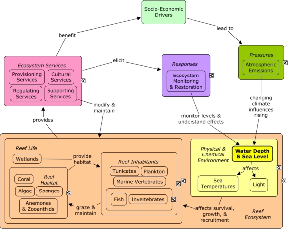
Water Depth & Sea Level
Water depth reflects the height between the bottom of the seafloor and water surface, and is often indicative of distinct ecological communities (shallow water species; deep water species). Sea level reflects the average height of the ocean surface, and determines water level and inundation patterns along coastlines.
CMap
CMap Description
Water depth will influence sea surface temperatures and the availability of light. Some reef species, such as certain coral or fish species, may be associated with a particular water depth (e.g., shallow water). Atmospheric emissions contribute to changing climate and influence rising sea levels. Monitoring and mapping can be used to predict sea level rise and the increasing potential for coastal flooding. Many of the same socio-economic sectors that create pressures on the reef also benefit from reef goods and services, such as shoreline protection that can minimize coastal flooding, and consequently property damage and loss of life during storm events.Citations
More than 50 citations. Click here to load.
| Citation | Year | Study Location | Study Type | Database Topics |
|---|
Management Options
| Management Option | Description | Sources | Database Topics |
|---|---|---|---|
| Agriculture & Aquaculture: Sodic Soil Management | In coastal agriculture it is important to manage and reduce accumulations of salts on the soil surface and down to the crop rooting depth. Saline seep often occurs in crop areas where the water table is very shallow. Irrigation management or drainage improvements may be necessary. Another option may be subsoiling, where internal soil drainage is restricted by layers of contrasting permeability and soil moisture levels are low enough to allow shattering and mixing of soil layers. Vegetative measures include planting deep rooted crops such as wheatgrass and alfalfa. Soil amendments can be used to treat sodium, displacing it with calcium depending on the specific chemistry of the soil. Though crop yield does not directly impact coral reefs, ground water restoration projects may change the raise the water table, making sodic soil management important. | Natural Resources Conservation Service. 2011. National Handbook of Conservation Practices. U.S. Department of Agriculture. |
Agriculture; Agriculture, Aquaculture, & Forestry Policies; Coastal Development; Ditching & Soil Disturbance; Food & Raw Materials; Landscape Conservation & Restoration; Salinity; Surface & Groundwater Flow; Water Depth & Sea Level |
| Damage Assessment, Documentation & Response: Respond to Natural Resource Injuries from Large Vessel Achoring | Damage from freighter anchor is extreme due to the mere weight and size of the anchor and chain. The chain can even be more damaging as it drags along the benthic environment leaving behind catastrophic ruin. This management response would encourage the creation of restoration and monitoring methodologies in shallow reef areas as well as at greater depths. If unacceptable damages are occurring restrictions and regulations prohibiting the use of anchors in high risk areas should be instituted. | NOAA Marine Sanctuary Program. 2007. Florida Keys National Marine Sanctuary revised management plan. National Ocean Service, Key West, FL. Collier, C., Dodge, R., Gilliiam, Gracie, K., Gregg, L., Jaap, W., Mastry, M., and Poulos, N. 2007. Rapid Response and Restoration for coral reef injuries in the southeest Florida. Southeast Florida Coral Reef Initiative. |
Anchoring & Vessel Grounding; Biological Monitoring & Restoration; Biological Monitoring, Mapping, & Scientific Research; Boating Activities; Boating Regulations; Cruise Ships; Ecosystem Monitoring & Restoration; Large Ships; Physical Damage; Resource Use Management; Transportation; Water Depth & Sea Level; Water Resources; Water Transportation; Wetland & Reef Restoration |
| Damage Assessment, Documentation & Response: Respond to Natural Resource Injuries form Derelict Vessels | Semi- permanent/permanent vessels can have a negative impact on the surrounding local environment both due to the effects of shade and from the direct contact with the substrate. Sunken vessels that cannot be seen from the surface may present a danger to navigation. Derelict vessels that do not remain stationary may cause harm in multiple locations before becoming stationary. If fishing gear is still intact, it may cause further biological damage through "ghost fishing� (#283). Early response, creating mooring fields, pump-out stations, and providing support for removing derelict vessels, reduces the impact of these vessels. Also, the removal of intrusive vessels will help contribute to the restoration of reef areas to previous conditions. | NOAA Marine Sanctuary Program. 2007. Florida Keys National Marine Sanctuary revised management plan. National Ocean Service, Key West, FL. |
Anchoring & Vessel Grounding; Artificial Habitat; Artisanal Fishing; Biological Monitoring & Restoration; Boat Movement; Boating Activities; Boating Regulations; Coastal Defense; Commercial Fishing Boats; Coral; Ecosystem Monitoring & Restoration; Environmental Monitoring & Restoration; Large Ships; Marine Debris; Military; Physical Damage; Reef Habitat; Reef Life; Resource Use Management; Seagrasses; Small Boats; Stony Coral; Substrate; Transportation Policies; Water Depth & Sea Level; Water Transportation; Wetlands |
| Energy Policy & Development: Oil and Gas Rig End of Life | As oil production at a given offshore site decreases it becomes necessary to decommission the rigs that were drilling them. It is very expensive to dismantle and transport the rigs back to shore. One such well know case was Shell's Brent Spar 1995. Regulations on the end of life for oil rigs differ by country and even state within the US. The Minerals Management Service has a Rigs-to-Reefs program which supports and encourages the reuse of oil and gas structures for offshore artificial reef developments. If these structures are to be sunk as artificial reefs the normal permit requirements for artificial reefs still apply to ensure the structure will not interfere with navigation channels or degrade the environment. | Dauterive, L. 1999. Rigs-to reefs policy, progress, and perspective. Pages 313-318 in SPE/EPA Exploration & Production Environmental Conference. |
Anchoring & Vessel Grounding; Artificial Habitat; Biological Addition; Chemical Variables; Civil Engineering & Construction; Construction Codes & Projects; Cultural Services; Discharge Limitations; Discharges; Infrastructural Policies; Infrastructure; Littering; Manufacturing & Trade; Marine Debris; Natural Gas & Electric Power; Oil & Gas Industry; Permitting & Zoning; Petroleum Spills; Point & Mobile Source Controls; Point Source Discharges; Provisioning Services; Solid Waste Disposal; Toxics; Utilities; Utility Policies; Waste Management; Water Depth & Sea Level; Water Resources |
| Monitor & Research: Research Historical Hydrology | This activity involves a historical assessment of the hydrology of the surrounding water area around the sanctuary as it has affected water quality and biological communities within the sanctuary. It will clarify the role of freshwater inflows and water quality from local freshwater bodies. Also, this activity will examine the effects of structural modification and changes in quality, quantity, timing and distribution of freshwater releases from existing structures and will examine land-based practices affecting the water quality of runoff. | NOAA Marine Sanctuary Program. 2007. Florida Keys National Marine Sanctuary revised management plan. National Ocean Service, Key West, FL. |
Applied Chemicals; Chemical Variables; Coastal Development; Coastal Engineering; Dam Construction & Maintenance; Deforestation & Devegetation; Discharge Limitations; Discharges; Ditching & Soil Disturbance; Dredging, Draining, & Filling; Ecosystem Monitoring & Restoration; Environmental Monitoring & Restoration; Environmental Monitoring, Mapping, & Scientific Research; Hydrologic Management; Impervious Surfaces; Infrastructural Policies; Landscape Changes; Landuse Management; Physical Variables; Salinity; Seawater Flow; Shoreline Armoring; Stormwater Management; Surface & Groundwater Flow; Water; Water Depth & Sea Level; Water Transportation; Waterborne Discharges |
| Monitor & Research: Research Global Change | This management option involves research to examine the effects of stresses associated with global change on the ecosystem. Stresses can include changes in temperature, hydrology, salinity, frequency and intensity of storms, turbidity, sea level change, and ultra violet and visible radiation. | NOAA Marine Sanctuary Program. 2007. Florida Keys National Marine Sanctuary revised management plan. National Ocean Service, Key West, FL. |
Atmospheric Emissions; Calcium Carbonate Deposition; Carbon Storage & Cycling; Chemical Variables; Climate; Climate Regulation; CO2; Discharges; Ecosystem Monitoring & Restoration; Environmental Monitoring & Restoration; Environmental Monitoring, Mapping, & Scientific Research; Greenhouse Gas Emissions; Nutrient & Contaminant Processing; Ocean Acidity; Physical & Chemical Water Quality Criteria; Physical Variables; Regulating Services; Salinity; Sea Temperatures; Seawater Flow; Shoreline Protection; Storms & Hurricanes; Supporting Services; Surface & Groundwater Flow; Water Depth & Sea Level |
| Regulatory Review and Development: Evaluate Channel & Reef Navigation Markers | This option would evaluate the need for proper marking to ensure better navigation. There are many types of markers, including buoys, charts, beacons, and GPS mapping. Such markers can also be used to advocate prohibition on vessel speeds greater than idle speed in areas designated as idle-speed only/no-wake and around shallow reef locations. | NOAA Marine Sanctuary Program. 2007. Florida Keys National Marine Sanctuary revised management plan. National Ocean Service, Key West, FL. |
Anchoring & Vessel Grounding; Beach & Land Formation; Boat Movement; Boating Activities; Boating Regulations; Coastal Development; Contact Uses; Cultural Services; Culture; Decision Support; Designated Uses; Dive, Snorkeling, & Swimming Tourism; Dredging Regulations; Permitting & Zoning; Physical Damage; Provisioning Services; Public Administration; Recreational Fishing; Recreational Opportunities; Security & Public Administration Policies; Small Boats; Tourism & Recreation; Trampling; Transportation Policies; Water Depth & Sea Level; Water Resources; Water Transportation |
| Waterway Management: Manage Canal Water Quality | This management option addresses water quality issues that may arise from nearshore, confined areas, specifically dead-end canals. This management response does not focus on wastewater discharges into canals, but instead on the hydrologic structure and orientation of the canal itself. Physical problems with canal orientation can lead to such problems as low flushing and build-up of weed wrack. This is a problem because the build-up of weed wrack consumes oxygen and releases nutrients as it decays. When combined with low flushing and circulation, dead end canals have decreased oxygen concentrations, accelerated eutrophication, and accumulate organic materials, pollutants and sediment. To improve the current canal system, management can inventory and map canals to identify high risk hotspots and candidates for future canal restoration projects. Canals are typically constructed to best suit the water access needs of local homes and businesses. Preventing high risk canals from being constructed, or placing certain requirements on their construction through permitting is one way to reduce future problem spots. Some design strategies include: Construct non-linear canals without right-angles and flared inlets oriented to prevailing winds. Instead of dead-ends, canals should include a flow through water exchange system or install mechanical pumps. Canals should be as wide as possible in relation to depth and length. Canal depth should be uniform or progressively shallower away from the parent waterbody, with sloping banks (eliminate requirements for navigable depths to shoreline). Some canal improvement strategies include: Implement weed gates, air curtains, and aeration systems. Direct all stormwater and effluent away from canal systems. Reduce bulkheading and restore native vegetative buffers (#1). Promote diversity of substrates and habitats. | NOAA Marine Sanctuary Program. 2007. Florida Keys National Marine Sanctuary revised management plan. National Ocean Service, Key West, FL. |
Applied Chemicals; Biological Monitoring & Restoration; Boat Movement; Boating Activities; Building & Home Construction; Chemical Variables; City Planning; Civil Engineering & Construction; Coastal Development; Coastal Engineering; Construction Codes & Projects; Decision Support; Deforestation & Devegetation; Discharge Limitations; Discharges; Ditching & Soil Disturbance; Docks & Marinas; Ecosystem Monitoring & Restoration; Environmental Monitoring & Restoration; Fishing Sector; Food & Energy Policies; Hydrologic Management; Improved Technology; Infrastructural Policies; Infrastructure; Land-Based Civil Engineering; Landscape Changes; Landscaping & Household Services; Landuse Management; Non-point Source Controls; Non-point Source Runoff; Nutrient & Contaminant Processing; Physical & Chemical Water Quality Criteria; Physical Damage; Physical Variables; Point & Mobile Source Controls; Point Source Discharges; Ports & Harbors; Provisioning Services; Regulating Services; Seawater Flow; Shoreline Armoring; Shoreline Protection; Small Boats; Surface & Groundwater Flow; Tourism & Recreation; Transportation; Transportation Policies; Utilities; Utility Policies; Waste Management; Waste Management Policies; Wastewater Discharge; Water; Water Depth & Sea Level; Water Resources; Water Transportation; Waterborne Discharges; Wetland & Reef Restoration; Wetlands |
Laws
| Legal Citation | Purpose of Law | Management Organization | Database Topics |
|---|---|---|---|
| Rules and Procedures for Coastal Construction and Excavation, 62B-033 Florida Administrative Code (2008). | (1) The beach and dune system is an integral part of the coastal system and represents one of the most valuable natural resources in Florida, providing protection to adjacent upland properties, recreational areas, and habitat for wildlife. A coastal construction control line (CCCL) is intended to define that portion of the beach and dune system which is subject to severe fluctuations caused by a 100-year storm surge, storm waves, or other forces such as wind, wave, or water level changes. These fluctuations are a necessary part of the natural functioning of the coastal system and are essential to post-storm recovery, long term stability, and the preservation of the beach and dune system. However, imprudent human activities can adversely interfere with these natural processes and alter the integrity and functioning of the beach and dune system. The control line and 50-foot setback call attention to the special hazards and impacts associated with the use of such property, but do not preclude all development or alteration of coastal property seaward of such lines.
(2) In order to demonstrate that construction is eligible for a permit, the applicant shall provide the Department with sufficient information pertaining to the proposed project to show that adverse and other impacts associated with the construction have been minimized and that the construction will not result in a significant adverse impact.
(3) After reviewing all information required pursuant to this rule chapter, the Department shall:
(a) Deny any application for an activity which either individually or cumulatively would result in a significant adverse impact including potential cumulative effects. In assessing the cumulative effects of a proposed activity, the Department shall consider the short-term and long-term impacts and the direct and indirect impacts the activity would cause in combination with existing structures in the area and any other similar activities already permitted or for which a permit application is pending within the same fixed coastal cell. The impact assessment shall include the anticipated effects of the construction on the coastal system and marine turtles. Each application shall be evaluated on its own merits in making a permit decision; therefore, a decision by the Department to grant a permit shall not constitute a commitment to permit additional similar construction within the same fixed coastal cell.
(b) Deny any application for an activity where the project has not met the Department�s siting and design criteria; has not minimized adverse and other impacts, including stormwater runoff; or has not provided mitigation of adverse impacts.
(4) The Department shall issue a permit for construction which an applicant has shown to be clearly justified by demonstrating that all standards, guidelines, and other requirements set forth in the applicable provisions of Part I, Chapter 161, F.S., and this rule chapter are met, including the following:
(a) The construction will not result in removal or destruction of native vegetation which will either destabilize a frontal, primary, or significant dune or cause a significant adverse impact to the beach and dune system due to increased erosion by wind or water;
(b) The construction will not result in removal or disturbance of in situ sandy soils of the beach and dune system to such a degree that a significant adverse impact to the beach and dune system would result from either reducing the existing ability of the system to resist erosion during a storm or lowering existing levels of storm protection to upland properties and structures;
(c) The construction will not direct discharges of water or other fluids in a seaward direction and in a manner that would result in significant adverse impacts. Forthe purposes of this rule section, construction shall be designed so as to minimize erosion induced surface water runoff within the beach and dune system and to prevent additional seaward or off-site discharges associated with a coastal storm event.
(d) The construction will not result in the net excavation of the in situ sandy soils seaward of the control line or 50-foot setback;
(e) The construction will not cause an increase in structure-induced scour of such magnitude during a storm that the structure-induced scour would result in a significant adverse impact;
(f) The construction will minimize the potential for wind and waterborne missiles during a storm;
(g) The activity will not interfere with public access, as defined in Section 161.021, F.S.; and
(h) The construction will not cause a significant adverse impact to marine turtles, or the coastal system.
(5) In order for a manmade frontal dune to be considered as a frontal dune defined under Section 161.053(6)(a)1., F.S., the manmade frontal dune shall be constructed to meet or exceed the protective value afforded by the natural frontal dune system in the immediate area of the subject shoreline. Prior to the issuance of a permit for a single-family dwelling meeting the criteria of Section 161.053(6)(c), F.S., the manmade frontal dune must be maintained for a minimum of 12 months and be demonstrated to be as stable and sustainable as the natural frontal dune system.
(6) Sandy material excavated seaward of the control line or 50-foot setback shall be maintained on site seaward of the control line or 50-foot setback and be placed in the immediate area of construction unless otherwise specifically authorized by the Department.
(7) Swimming pools, wading pools, waterfalls, spas, or similar type water structures are expendable structures and shall be sited so that their failure does not have adverse impact on the beach and dune system, any adjoining major structures, or any coastal protection structure. Pools sited within close proximity to a significant dune shall be elevated either partially or totally above the original grade to minimize excavation and shall not cause a net loss of material from the immediate area of the pool. All pools shall be designed to minimize any permanent excavation seaward of the CCCL.
(8) Major structures shall be located a sufficient distance landward of the beach and frontal dune to permit natural shoreline fluctuations, to preserve and protect beach and dune system stability, and to allow natural recovery to occur following storm-induced erosion. Where a rigid coastal structure exists, proposed major structures shall be located a sufficient distance landward of the rigid coastal structure to allow for future maintenance or repair of the rigid coastal structure. Although fishing piers shall be exempt from this provision, their foundation piles shall be located so as to allow for the maintenance and repair of any rigid coastal structure that is located in close proximity to the pier.(9) If in the immediate area a number of existing major structures have established a reasonably continuous and uniform construction line and if the existing structures have not been unduly affected by erosion, except where not allowed by the requirements of Section 161.053(6), F.S., and this rule chapter, the Department shall issue a permit for the construction of a similar structure up to that line.
(10) In considering applications for single-family dwellings proposed to be located seaward of the 30-year erosion projection pursuant to Section 161.053(6), F.S., the Department shall require structures to meet criteria in Section 161.053(6)(c), F.S., and all other siting and design criteria established in this rule chapter.
(11) In considering project impacts to native salt-tolerant vegetation, the Department shall evaluate the type and extent of native salt-tolerant vegetation, the degree and extent of disturbance by invasive nuisance species and mechanical and other activities, the protective value to adjacent structures and natural plant communities, the protective value to the beach and dune system, and the impacts to marine turtle nesting and hatchlings. The Department shall restrict activities that lower the protective value of natural and intact beach and dune, coastal strand, and maritime hammock plant communities. Activities that result in the removal of protective root systems or reduce the vegetation�s sand trapping and stabilizing properties of salt tolerant vegetation are considered to lower its protective value. Construction shall be located, where practicable, in previously disturbed areas or areas with non-native vegetation in lieu of areas of native plant communities when the placement does not increase adverse impact to the beach and dune system. Planting of invasive nuisance plants, such as those listed in the Florida Exotic Pest Plant Council�s 2005 List of Invasive Species � Categories I and II, will not be authorized if the planting will result in removal or destruction of existing dune-stabilizing native vegetation or if the planting is to occur on or seaward of the dune system. A copy of this list is available on the Internet at www.fleppc.org; or can be obtained by writing to the Department of Environmental Protection, Bureau of Beaches and Coastal Systems, 3900 Commonwealth Boulevard, Mail Station 300, Tallahassee, Florida 32399-3000; or by telephoning (850) 488-7708. Special conditions relative to the nature, timing, and sequence of construction and the remediation of construction impacts shall be placed on permitted activities when necessary to protect native salt-tolerant vegetation and native plant communities. A construction fence, a designated location for construction access or storage of equipment and materials, and a restoration plan shall be required if necessary for protection of existing native salt-tolerant vegetation during construction.
(12) Special conditions relative to the nature, timing, and sequence of construction shall be placed on permitted activities when necessary to protect marine turtles and their nests and nesting habitat. In marine turtle nesting areas, all forms of lighting shall be shielded or otherwise designed so as not to disturb marine turtles. Tinted glass or similar light control measures shall be used for windows and doors which are visible from the nesting areas of the beach. The Department shall suspend any permitted construction when the permittee has not provided the required protection for marine turtles and their nests and nesting habitat. Application to Coral Reefs:Regulation of coastal construction through permit review and modification will protect coastal ecosystems from degradation and loss and in doing so protects other marine ecosystems including coral reefs. Legislative Actions:Chapter 62B-33 Florida Administrative Code, provides the design and siting requirements that must be met to obtain a coastal construction control line permit.Approval or denial of a permit application is based upon a review of the potential impacts to the beach dune system, adjacentproperties, native salt resistant vegetation, and marine turtles. Comments:The Coastal Construction Control Line (CCCL) is an essential element of Florida's coastal management program. It provides protection for Florida's beaches and dunes while assuring reasonable use of private property. Recognizing the value of the state's beaches, the Florida legislature initiated the Coastal Construction Contorl Line Program to protect the coastal system from improperly sited and designed structures which can destabilize or destroy the beach and dune system. Once destabilized, the valuable natural resources are lost, as are its important values for recreation, upland property protection and environmental habitat. Adoption of a coastal construction line establishes an area of jurisdiction in which special siting and design criteria are applied for construction and related activities.These standards may be more stringent than those already applied in the rest of the coastal building zone because of the greater forces expected to occur in the more seaward zone of the beach during a storm event. |
Florida State Department of Environmental Protection Jurisdiction: State Coastal Waters; Designated Marine Areas |
Beach & Land Formation; Building & Home Construction; City Planning; Civil Engineering & Construction; Coastal Development; Construction Codes & Projects; Cruise Ships; Docks & Marinas; Dredging Regulations; Dredging, Draining, & Filling; Hydrologic Management; Landuse Management; Mangroves; Marine Protected Areas; Oil & Gas Tankers; Pipelines; Ports & Harbors; Resource Use Management; Seagrasses; Seawater Flow; Sediment; Shoreline Armoring; Shoreline Protection; Storms & Hurricanes; Tourism & Recreation Policies; Water Depth & Sea Level |