ReefLink Database
Trampling
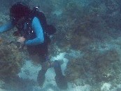
Trampling occurs when humans walk on, kick, bump into, or touch corals.
CMap
CMap Description
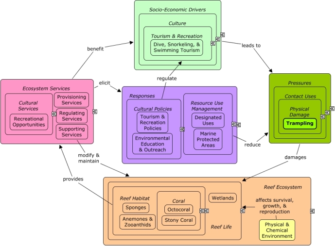
Recreational activities by humans swimming, snorkeling, or diving over reefs can damage coral through trampling. Many of the same socio-economic sectors that cause physical damage, also benefit from reef ecosystem services, including provision of shoreline protection, recreational value, seafood, and other marine products. Resource use management can be used to minimize physical damage by establishing protected areas, boating regulations, fishing regulations, or limiting dredging. Physical damage can be ameliorated through restoration projects to restore damaged wetlands or reef habitat. Education and outreach can be used to alter people's behavior about trampling.Citations
| Citation | Year | Study Location | Study Type | Database Topics |
|---|---|---|---|---|
| Hannak, JS; Kompatscher, S; Stachowitsch, M; Herler, J. 2011. Snorkelling and trampling in shallow-water fringing reefs: Risk assessment and proposed management strategy. Journal of Environmental Management 92:2723-2733. | 2011 | Cuba; Egypt | Model; Index or Indicator | Banks, Credit, & Securities; Dive, Snorkeling, & Swimming Tourism; Finfish Harvest; Sediment; Stony Coral; Substrate; Tourism & Recreation; Trampling |
| Long, JD; Cochrane, E; Dolecal, RE. 2011. Previous disturbance enhances the negative effects of trampling on barnacles. Marine Ecology Progress Series 437:165-173. | 2011 | Trampling | ||
| Sarmento, VC; Barreto, AFS; Santos, PJP. 2011. The response of meiofauna to human trampling on coral reefs. Scientia Marina 75:559-570. | 2011 | Algae; Marine Worms; Substrate; Tourism & Recreation; Trampling | ||
| Claudet, J., P. Lenfant, and M. Schrimm. 2010. Snorkelers impact on fish communities and algae in a temperate marine protected area. Biodiversity and Conservation 19:1649-1658. | 2010 | Index or Indicator | Algae; Dive, Snorkeling, & Swimming Tourism; Fish; Marine Protected Areas; Octocoral; Tourism & Recreation; Trampling | |
| Batista, J. B., R. M. V. Leonel, and M. A. J. Costa. 2009. Population characteristics of Microphrys bicornutus (Brachyura, Mithracidae) on the phytal Halimeda opuntia (Chlorophyta, Halimedaceae), on reef area submitted to human visitation, in Joao Pessoa, Paraiba, Brazil. Iheringia Serie Zoologia 99:44-52. | 2009 | Algae; Calcareous Macroalgae; Salinity; Tourism & Recreation; Trampling | ||
| Addison, P. F. E., R. S. Koss, and T. D. O'Hara. 2008. Recreational use of a rocky intertidal reef in Victoria: Implications for ecological research and management. Australasian Journal of Environmental Management 15:169-179. | 2008 | Australia | Complex Habitat & Resources; Environmental Education & Outreach; Tourism & Recreation; Trampling | |
| Leujak, W. and R. F. G. Ormond. 2008. Quantifying acceptable levels of visitor use on Red Sea reef flats. Aquatic Conservation: Marine and Freshwater Ecosystems 18:930-944. | 2008 | Egypt | Decision Support Frameworks & Tools | Corallivorous Fish; Dive, Snorkeling, & Swimming Tourism; Skeletal Coral; Stony Coral; Tourism & Recreation; Trampling |
| Leujak, W. and R. F. G. Ormond. 2008. Reef walking on Red Sea reef flats - Quantifying impacts and identifying motives. Ocean and Coastal Management 51:755-762. | 2008 | Octocoral; Sediment; Stony Coral; Trampling | ||
| Meixia, Z., Y. Kefu, Z. Qiaomin, and S. Qi. 2008. Spatial pattern of coral diversity in Luhuitou fringing reef, Sanya, China. Acta Ecologica Sinica 28:1419-1428. | 2008 | China | Index or Indicator | Aquaculture; Dredging, Draining, & Filling; Finfish Harvest; Stony Coral; Trampling |
| Bailey-Brock, J., R. Brock, A. Kam, A. Fukunaga, and H. Akiyama. 2007. Anthropogenic disturbance on shallow cryptofaunal communities in a marine life conservation district on Oahu, Hawaii. International Review of Hydrobiology 92:291-300. | 2007 | US Pacific & Hawaii | Finfish Harvest; Fish; Marine Worms; Skeletal Coral; Trampling | |
| Leujak, W. and R. F. G. Ormond. 2007. Visitor perceptions and the shifting social carrying capacity of South Sinai's coral reefs. Environmental Management 39:472-489. | 2007 | Egypt | Dive, Snorkeling, & Swimming Tourism; Tourism & Recreation; Trampling | |
| Roman, G. S. J., P. Dearden, and R. Rollins. 2007. Application of zoning and \limits of acceptable change\" to manage snorkelling tourism". Environmental Management 39:819-830. | 2007 | Thailand | Field Study & Monitoring; Index or Indicator | Dive, Snorkeling, & Swimming Tourism; Fishing Sector; Landuse Management; Marine Protected Areas; Tourism & Recreation; Trampling |
| Davenport, J. and J. L. Davenport. 2006. The impact of tourism and personal leisure transport on coastal environments: A review. Estuarine Coastal and Shelf Science 67:280-292. | 2006 | Cuba | Review | Beaches & Nature Parks; Boating Regulations; Cruise Ships; Dive, Snorkeling, & Swimming Tourism; Docks & Marinas; Hotel & Food Services; Infrastructure; Invasive Species; Land & Air Transportation; Small Boats; Tourism & Recreation; Trampling |
| Littlewood, D. T. J. and S. K. Donovan. 2003. Fossil parasites: A case of identity. Geology Today 19:136-142. | 2003 | Echinoderms; Trampling | ||
| Rodgers, K. S. and E. F. Cox. 2003. The effects of trampling on Hawaiian corals along a gradient of human use. Biological Conservation 112:383-389. | 2003 | US Pacific & Hawaii | Trampling | |
| Rodgers, K., E. Cox, and C. Newtson. 2003. Effects of mechanical fracturing and experimental trampling on Hawaiian corals. Environmental Management 31:377-384. | 2003 | US Pacific & Hawaii | Shoreline Protection; Stony Coral; Trampling | |
| Talbot, L. M., S. M. Turton, and A. W. Graham. 2003. Trampling resistance of tropical rainforest soils and vegetation in the wet tropics of north east Australia. Journal of Environmental Management 69:63-69. | 2003 | Australia | Littering; Seagrasses; Trampling | |
| Brown, P. J. and R. B. Taylor. 1999. Effects of trampling by humans on animals inhabiting coralline algal turf in the rocky intertidal. Journal of Experimental Marine Biology and Ecology 235:45-53. | 1999 | Algae; Marine Protected Areas; Marine Worms; Trampling | ||
| Hawkins, J. P. and C. M. Roberts. 1993. Effects of recreational scuba diving on coral reefs: trampling on reef-flat communities. Journal of Applied Ecology 30:25-30. | 1993 | Cuba; Egypt | Dive, Snorkeling, & Swimming Tourism; Hotel & Food Services; Skeletal Coral; Stony Coral; Tourism & Recreation; Trampling | |
| Liddle, M. J. 1991. Recreation ecology: Effects of trampling on plants and corals. Trends in Ecology and Evolution 6:13-17. | 1991 | Review | Boating Activities; Boating Regulations; Tourism & Recreation; Trampling | |
| Neil, D. 1990. Potential for Coral stress due to sediment resuspension and deposition by reef walkers. Biological Conservation 52:221-227. | 1990 | Australia | Sediment; Trampling | |
| Kay, A. M. and M. J. Liddle. 1989. Impact of human trampling in different zones of a coral reef flat. Environmental Management 13:509-520. | 1989 | Trampling | ||
| Liddle, M. J. and A. M. Kay. 1987. Resistance, survival and recovery of trampled corals on the Great Barrier Reef. Biological Conservation 42:18-Jan. | 1987 | Australia | Field Study & Monitoring; Lab Study | Physical Damage; Stony Coral; Tourism & Recreation; Trampling |
| Woodland, D. J. and J. N. A. Hooper. 1977. The effect of human trampling on coral reefs. Biological Conservation 11:4-Jan. | 1977 | Dredging, Draining, & Filling; Trampling |
Management Options
| Management Option | Description | Sources | Database Topics |
|---|---|---|---|
| Environmental Education: Deliver Non-Enforcement Resource Eductaion at the Resource Site | Voluntary compliance (#50) is the most desirable form of site protection. Lack of compliance often occurs unintentionally, due to a lack of knowledge and understanding. Law enforcement plays a role by ensuring rules are appropriately followed, but often the preventative component of this enforcement becomes secondary, especially on high use days/areas. Volunteers can assist by answering questions and talking to people recreating about the reef, reef resources, and how to appropriately recreate. Volunteers can watch to ensure people are acting appropriately, that boaters do not go too close to shallow reefs, and that groundings do not occur. Programs such as Team OCEAN have contributed over 15,000 hours to such activities. | NOAA Marine Sanctuary Program. 2007. Florida Keys National Marine Sanctuary revised management plan. National Ocean Service, Key West, FL. |
Beaches & Nature Parks; Boat Movement; Boating Activities; Collaboration & Partnering; Cultural Policies; Culture; Dive, Snorkeling, & Swimming Tourism; Education & Information; Environmental Education & Outreach; Finfish Harvest; Invertebrate Harvest; Marine Debris; Recreational Fishing; Recreational Opportunities; Resource Use Management; Social Organizations; Sunscreen Use; Tourism & Recreation; Tourism & Recreation Policies; Trampling |
| Marine Zoning: Wildlife Management Areas (WMAs) | Wildlife Management Areas include bird nesting, resting, or feeding areas, turtle nesting beaches, and other sensitive habitats including shallow flats that are important feeding areas for fish. These areas seek to provide protection for endangered/threatened species or their habitats while at the same time providing opportunity for public use. Wildlife Management Areas are achieved through placing and maintaining buoys along zone boundaries; implementing management responsibilities; adjusting existing zone boundaries if needed; evaluating allowable activities within the boundaries and make changes if needed; identifying potential areas that need additional zoning; monitoring the effectiveness of current zones; and revising GIS and NOAA charts. | NOAA Marine Sanctuary Program. 2007. Florida Keys National Marine Sanctuary revised management plan. National Ocean Service, Key West, FL. |
Accidental & Illegal Harvest; Beaches & Nature Parks; Biological Harvest; Biological Monitoring & Restoration; Boating Activities; Coastal Defense; Contact Uses; Cultural Services; Decision Support; Designate Protected Species; Designated Uses; Ecosystem Monitoring & Restoration; Entertainment & Accommodation Services; Environmental Monitoring & Restoration; Fisheries & Hunting Policies; Fishing & Harvesting Management; Fishing Sector; Landscape Conservation & Restoration; Marine Birds; Marine Protected Areas; Permitting & Zoning; Physical Damage; Recreational Fishing; Recreational Opportunities; Resource Use Management; Sea Turtles; Tourism & Recreation; Trampling; Water Transportation; Wetlands |
| Marine Zoning: Sanctuary Preservation Areas (SPAs) | This is a type of Marine Zoning used by the Florida Keys National Marine Sanctuary (FKNMS). SPAs focus on the protection of shallow, heavily used reefs where conflicts occur between user groups, and where concentrated visitor activity leads to resource degradation. They are designed to enhance the reproductive capabilities of renewable resources, protect areas critical for sustaining and protecting important marine species, and reduce user conflicts in high-use areas. This is accomplished through a prohibition of consumptive activities within these areas. They have been chosen based on the status of important habitat, the ability of a particular area to sustain and protect the habitat, the level of visitor use, and the degree of conflict between consumptive and non-consumptive users. The actual size and location of these zones have been determined by examination of user patterns, aerial photography, and ground-truthing of specific habitats. | NOAA Marine Sanctuary Program. 2007. Florida Keys National Marine Sanctuary revised management plan. National Ocean Service, Key West, FL. |
Accidental & Illegal Harvest; Anchoring & Vessel Grounding; Aquaculture; Aquarium & Pet Trade; Aquarium Stock; Artisanal Fishing; Beaches & Nature Parks; Biological Addition; Biological Harvest; Biological Monitoring & Restoration; Boat Movement; Boating Activities; Boating Regulations; Coastal Defense; Coastal Development; Coastal Engineering; Commercial Fisheries; Commercial Fishing Boats; Complex Habitat & Resources; Cruise Ships; Cultural Services; Decision Support; Designated Uses; Dive, Snorkeling, & Swimming Tourism; Dredging Regulations; Dredging, Draining, & Filling; Ecosystem Monitoring & Restoration; Educational & Research Opportunities; Entertainment & Accommodation Services; Environmental Monitoring & Restoration; Finfish & Shellfish Stock; Finfish Harvest; Fisheries & Hunting Policies; Fishing & Harvesting Management; Fishing Sector; Invertebrate Harvest; Landscape Changes; Large Ships; Live Collection; Marine Protected Areas; Oil & Gas Tankers; Ornamental Jewelry & Art; Permitting & Zoning; Physical Damage; Public Administration; Recreational Fishing; Recreational Opportunities; Resource Use Management; Security; Small Boats; Souvenir & Decorative Trade; Supporting Services; Tourism & Recreation; Tourism & Recreation Policies; Trampling; Travel Services & Tour Operators; Trawling & Fishing Gear Damage; Water Resources; Water Transportation |
| Marine Zoning: Ecological Reserves (ERs) | Ecological Reserves set aside areas with minimal human interference. These reserves aim to enhance and protect biodiversity through encompassing large, contiguous habitats. The goal of ecological reserves is to encourage spawning, nurseries, and residence areas that contribute to genetic protection of fish and marine life. Ecological Reserves can be achieved through a variety of methods such as: placing/maintaining buoys along zone boundaries; adjusting boundaries if necessary; evaluating allowable activities within zone boundaries; identifying potential areas that need additional zoning; reviewing the effectiveness of the zoning; and revising NOAA and GIS charts. | NOAA Marine Sanctuary Program. 2007. Florida Keys National Marine Sanctuary revised management plan. National Ocean Service, Key West, FL. |
Biochemical & Genetic Resources; Biological Addition; Biological Harvest; Biological Monitoring & Restoration; Boating Activities; Boating Regulations; Coastal Defense; Commercial Fishing Boats; Complex Habitat & Resources; Cruise Ships; Decision Support; Designated Uses; Dredging Regulations; Dredging, Draining, & Filling; Ecosystem Monitoring & Restoration; Environmental Monitoring & Restoration; Finfish Harvest; Fisheries & Hunting Policies; Fishing & Harvesting Management; Fishing Sector; Invertebrate Harvest; Large Ships; Live Collection; Marine Protected Areas; Oil & Gas Tankers; Permitting & Zoning; Physical Damage; Provisioning Services; Resource Use Management; Security Policies; Small Boats; Tourism & Recreation; Trampling; Water Transportation |
| Regulatory Review and Development: Evaluate Coral Touching Regulations | Currently touching, removing, damaging, distributing, and injuring any living or dead coral or coral formation is prohibited in Sanctuary Preservation Areas and Ecological Reserves. An investigation will be conducted to consider extending this prohibition to high-use, sensitive and vulnerable areas. | NOAA Marine Sanctuary Program. 2007. Florida Keys National Marine Sanctuary revised management plan. National Ocean Service, Key West, FL. |
Beaches & Nature Parks; Contact Uses; Coral; Decision Support; Dredging Regulations; Physical Damage; Skeletal Coral; Stony Coral; Tourism & Recreation; Tourism & Recreation Policies; Trampling |
| Regulatory Review and Development: Evaluate Channel & Reef Navigation Markers | This option would evaluate the need for proper marking to ensure better navigation. There are many types of markers, including buoys, charts, beacons, and GPS mapping. Such markers can also be used to advocate prohibition on vessel speeds greater than idle speed in areas designated as idle-speed only/no-wake and around shallow reef locations. | NOAA Marine Sanctuary Program. 2007. Florida Keys National Marine Sanctuary revised management plan. National Ocean Service, Key West, FL. |
Anchoring & Vessel Grounding; Beach & Land Formation; Boat Movement; Boating Activities; Boating Regulations; Coastal Development; Contact Uses; Cultural Services; Culture; Decision Support; Designated Uses; Dive, Snorkeling, & Swimming Tourism; Dredging Regulations; Permitting & Zoning; Physical Damage; Provisioning Services; Public Administration; Recreational Fishing; Recreational Opportunities; Security & Public Administration Policies; Small Boats; Tourism & Recreation; Trampling; Transportation Policies; Water Depth & Sea Level; Water Resources; Water Transportation |
| Regulatory Review and Development: Change Salvaging & Towing Practices | This option seeks to protect natural resources and reduce damage resulting from improper vessel salvage methods. In the past, salvage techniques have caused collateral damage when removing vessels grounded on the reef. These injuries often occur in the immediate area surrounding the grounded vessel but can be avoided with the use of proper salvage techniques developed with reef resources in mind. The principal causes of collateral injuries are dragging a vessel off the reef instead of floating it off; the use of steel towing cables that can drop on or drag across the substrate, impacting and dislodging resources (reef structure, corals, and sponges); and propwash and surge, generated by tugboat propellers, that displace sediment and dislodge organisms. To avoid or minimize collateral injuries, a reconnaissance survey should be conducted while the vessel is grounded to evaluate reef resources in the immediate area surrounding the vessel and determine an appropriate extraction route. Bunker fuel and cargo may need to be offloaded. Floating or buoyed towlines should be used instead of steel cables, and towing activities should be conducted at or near high tide to facilitate floating the vessel. Before and during the extraction, global positioning system (GPS) coordinates at the bow and stern of the vessel should be recorded to assist with future injury assessment. GPS tracking should be operating on the grounded vessel during egress from the site and on all salvage vessels or tugboats involved with the salvage operation. The outbound path for vessel extraction may also need to be buoyed, to help avoid or identify injuries that may occur during the salvage operation. | NOAA Marine Sanctuary Program. 2007. Florida Keys National Marine Sanctuary revised management plan. National Ocean Service, Key West, FL. |
Anchoring & Vessel Grounding; Boat Movement; Boating Activities; Boating Regulations; Coastal Engineering; Collaboration & Partnering; Contact Uses; Decision Support; Dredging Regulations; Dredging, Draining, & Filling; Environmental Education & Outreach; Improved Technology; Infrastructural Policies; Physical Damage; Resource Use Management; Security & Public Administration Policies; Trampling; Transportation; Transportation Policies; Water Transportation |
| Restoration: Beach Vegatation Restoration | Natural beaches are often host to important costal dune ecosystems. Due to tourism, much of the vegetation that comprises these dune ecosystems may be compromised. The natural vegetation provides an important ecosystem service, with roots providing deep stabilization against physical damage and removal of that sand. Without such vegetation sand and dunes can be completely washed away during hurricanes and other surge events. The dunes themselves offer some protection to nearby inland infrastructure during these same storm events. When the beach past the dunes is for public access it is beneficial to build raised walk-overs over the dune vegetation. This prevents trampling, which leads to dune blowouts. | Natural Resources Conservation Service, editor. 2007. Native Plants for Coastal Dune Restoration: What, When, and How for Florida. US Department of Agriculture. |
Beaches & Nature Parks; Biological Monitoring & Restoration; Culture; Deforestation & Devegetation; Ditching & Soil Disturbance; Ecosystem Monitoring & Restoration; Invasive Species; Landscape Changes; Landscape Conservation & Restoration; Landuse Management; Physical Damage; Regulating Services; Storms & Hurricanes; Tourism & Recreation; Trampling |
| Waterway Management: Waterway Management/Marking Plan | Proper waterway markings provide coherent guidance for boats. Clearly-marked waterway exits and entrances reduce the probability of damage to reefs from boat gear damage, boat movement, trampling, and ballast discharge. Waterway marking can be achieved through surveying damage from propeller scarring and vessel groundings, enhancing channel marking aids, assessing the effectiveness of channel marking, and through removing waterway obstructions. "Hotspots" where many incidents have been reported should be considered for further marking, especially those that are in high use areas. | NOAA Marine Sanctuary Program. 2007. Florida Keys National Marine Sanctuary revised management plan. National Ocean Service, Key West, FL. |
Anchoring & Vessel Grounding; Boat Movement; Boating Activities; Boating Regulations; Contact Uses; Decision Support; Dredging Regulations; Dredging, Draining, & Filling; Physical Damage; Resource Use Management; Trampling; Trawling & Fishing Gear Damage; Water; Water Transportation |
| Waterway Management: Boat Access Plan | An optimal boat access strategy involves conducting a survey of all public and private boat access points throughout the area. Once entry and exit sites are identified, channel markings can be placed accordingly. An effective strategy must also consider boat access needs, location, and intensity of use. This will help to efficiently mark the waterways so that there can be a reduction in damage to reefs, seagrasses and wetlands. | NOAA Marine Sanctuary Program. 2007. Florida Keys National Marine Sanctuary revised management plan. National Ocean Service, Key West, FL. |
Anchoring & Vessel Grounding; Artisanal Fishing; Boat Movement; Boating Activities; Boating Regulations; Commercial Fisheries; Contact Uses; Cultural Policies; Culture; Decision Support; Dive, Snorkeling, & Swimming Tourism; Dredging, Draining, & Filling; Landscape Changes; Physical Damage; Public Administration; Recreational Fishing; Resource Use Management; Security; Security & Public Administration Policies; Tourism & Recreation; Tourism & Recreation Policies; Trampling; Transportation; Trawling & Fishing Gear Damage; Water; Water Resources; Water Transportation |
Laws
| Legal Citation | Purpose of Law | Management Organization | Database Topics |
|---|