ReefLink Database

Surface & Groundwater Flow
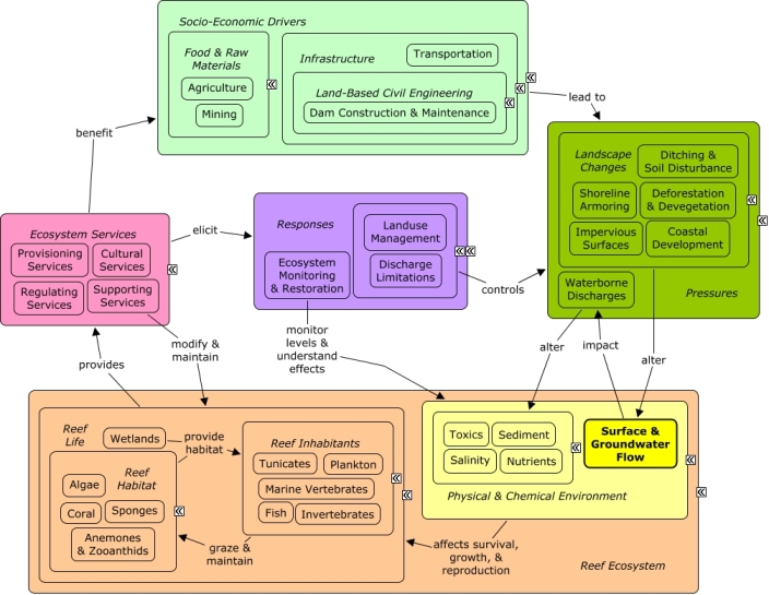
Surface and groundwater flow reflects the patterns of water movement across the landscape, including rivers, streams, underground water, or stormwater.
CMap
CMap Description
Human activities that alter the landscape, including devegetation or soil disturbance, can alter surface and groundwater flow, causing freshwater discharge or runoff that alters salinity levels, or transporting nutrients, sediments, or toxic chemicals into coastal ecosystems. Increased impervious surface area in developed landscapes can contribute to higher maximum flows and lower minimum flows in rivers and streams than those in more pristine settings. This "flashy" flow pattern degrades riverine habitat, can create "pulses" of freshwater flow into coastal waters, and causes property flooding. Water flow and contaminant levels can be monitored and mapped to target sources of inputs or potentially vulnerable areas. Landuse or hydrological management, agricultural practices, or mining practices can be implemented to minimize soil disturbance, impervious surfaces, and devegetation that alter surface and groundwater flow. Many of the same socio-economic sectors, such as transportation, civil engineering, and construction that create pressures on the reef also benefit from reef goods and services, such as shoreline protection or recreational opportunities that contribute to the cultural identity of the local community.Citations
More than 50 citations. Click here to load.
| Citation | Year | Study Location | Study Type | Database Topics |
|---|
Management Options
| Management Option | Description | Sources | Database Topics |
|---|---|---|---|
| Agriculture & Aquaculture: Sodic Soil Management | In coastal agriculture it is important to manage and reduce accumulations of salts on the soil surface and down to the crop rooting depth. Saline seep often occurs in crop areas where the water table is very shallow. Irrigation management or drainage improvements may be necessary. Another option may be subsoiling, where internal soil drainage is restricted by layers of contrasting permeability and soil moisture levels are low enough to allow shattering and mixing of soil layers. Vegetative measures include planting deep rooted crops such as wheatgrass and alfalfa. Soil amendments can be used to treat sodium, displacing it with calcium depending on the specific chemistry of the soil. Though crop yield does not directly impact coral reefs, ground water restoration projects may change the raise the water table, making sodic soil management important. | Natural Resources Conservation Service. 2011. National Handbook of Conservation Practices. U.S. Department of Agriculture. |
Agriculture; Agriculture, Aquaculture, & Forestry Policies; Coastal Development; Ditching & Soil Disturbance; Food & Raw Materials; Landscape Conservation & Restoration; Salinity; Surface & Groundwater Flow; Water Depth & Sea Level |
| Agriculture & Aquaculture: Waterspreading | This management option uses a system of dams, dikes, ditches, or other means of diverting or collecting runoff from natural channels, gullies, or streams and spreading it over relatively flat areas. Waterspreading differs from irrigation in that applications are timed by the availability of natural runoff flow rather than scheduled to meet plant needs. Waterspreading is most beneficial in areas with an average annual precipitation of 8 to 25 inches. | Natural Resources Conservation Service. 2011. National Handbook of Conservation Practices. U.S. Department of Agriculture. |
Agriculture; Agriculture, Aquaculture, & Forestry Policies; Food & Raw Materials; Landuse Management; Surface & Groundwater Flow; Water; Water Resources |
| Forestry Policy: Forest Chemical Management | Pesticides and fertilizers are commonly used in forestry to reduce mortality of desired trees, improve forest production, and ease harvest/extraction. The rate of application is typically very low, but given the overall area covered, pesticides can still accumulate within watersheds. Some forest management chemical use considerations to reduce nonpoint source pollution impacts include: Develop an effective spill contingency plan to contain spills, and immediately report accidental spills into surface waters to the appropriate State agency. Prior to application, inspect the mixing and loading process and the calibration of equipment, and identify the appropriate weather conditions, the spray area, and buffer areas for surface waters. Buffer areas for surface waters are especially important for aerial applications. Carefully prescribe the type and amount of pesticides appropriate for the insect, fungus, or herbaceous species. | Environmental Protection Agency Office of Water. 1993. Guidance Specifying Management Measures For Sources Of Nonpoint Pollution In Coastal Waters. EPA/840/B-92/002, US EPA, Washington, DC. |
Agriculture, Aquaculture, & Forestry Policies; Applied Chemicals; Chemical Use Regulations; Discharge Limitations; Discharges; Fertilizer & Pesticide Use; Forestry; Non-point Source Controls; Nutrients; Provisioning Services; Surface & Groundwater Flow; Toxics; Water Resources; Wood, Plastics, & Chemical Products |
| Forestry Policy: Forestry Management Planning | There are many aspects to properly managing forestry sites to reduce point source and non-point source pollutants. Forestry activities can degrade water quality with several types of pollutants and impacts, including: sediment, nutrients, forest chemicals like pesticides, organic debris from tree litter, increased water temperature and increased streamflow. The Forestry management plan and practices include, but are not limited to: pre-harvest planning, road construction and use, prescribed burning and fire management, brush management, timber harvest, regeneration, and application of forest chemicals. Wetlands Forest Management has additional best practices. | Environmental Protection Agency Office of Water. 1993. Guidance Specifying Management Measures For Sources Of Nonpoint Pollution In Coastal Waters. EPA/840/B-92/002, US EPA, Washington, DC. Natural Resources Conservation Service. 2011. National Handbook of Conservation Practices. U.S. Department of Agriculture. |
Agriculture, Aquaculture, & Forestry Policies; Applied Chemicals; Biological Harvest; Chemical Use Regulations; Civil Engineering & Construction; Deforestation & Devegetation; Discharge Limitations; Ditching & Soil Disturbance; Fertilizer & Pesticide Use; Food & Raw Materials; Forestry; Landscape Changes; Landscape Conservation & Restoration; Landuse Management; Manufacturing & Trade; Non-point Source Controls; Non-point Source Runoff; Nutrients; Physical & Chemical Water Quality Criteria; Point & Mobile Source Controls; Point Source Discharges; Regulating Services; Resource Use Management; Sediment; Supporting Services; Surface & Groundwater Flow; Toxics; Waterborne Discharges; Wetlands; Wood, Plastics, & Chemical Products |
| Forestry Policy: Forestry Streamside Management Areas | There are often surface waters, such as streams and lakes, within forestry areas that require special protection. This management option involves establishing and maintaining management areas (35 to 50 feet) around these surface waters to buffer against changes in temperature, increases in sediments and nutrients, and to provide bank stability. Canopy species in these areas also provide woody debris needed for instream channel structure and aquatic species habitat. | Environmental Protection Agency Office of Water. 1993. Guidance Specifying Management Measures For Sources Of Nonpoint Pollution In Coastal Waters. EPA/840/B-92/002, US EPA, Washington, DC. Natural Resources Conservation Service. 2011. National Handbook of Conservation Practices. U.S. Department of Agriculture. |
Agriculture, Aquaculture, & Forestry Policies; Carbon Storage & Cycling; Civil Engineering & Construction; Construction Codes & Projects; Deforestation & Devegetation; Discharges; Ditching & Soil Disturbance; Food & Raw Materials; Forestry; Impervious Surfaces; Infrastructural Policies; Landscape Changes; Landscape Conservation & Restoration; Landuse Management; Non-point Source Runoff; Point & Mobile Source Controls; Primary Production; Sediment; Surface & Groundwater Flow; Waterborne Discharges; Wood, Plastics, & Chemical Products |
| Landuse Management: Mine Reclamation | Lands disturbed by mining must be reclaimed to their Approximate Original Contour (AOC). Mine operators must backfill, compact, and grade in order to restore the AOC of the land with all highwalls, spoil piles, and depressions eliminated. Spoil material is prone to erosion, and may carry various disturbed toxics into groundwater if not properly managed. Temporary roads and impervious surfaces may have also been constructed for mining purposes. | Natural Resources Conservation Service. 2011. National Handbook of Conservation Practices. U.S. Department of Agriculture. Office of Surface Mining Reclamation and Enforcement. POSTMINING LAND USE: Exceptions to Approximate Original Contour Requirements for Mountaintop Removal Operations and steep Slope Mining Operations. Washington, DC. |
Chemical Use Regulations; Civil Engineering & Construction; Coal Mining; Construction Codes & Projects; Decision Support; Deforestation & Devegetation; Discharge Limitations; Discharges; Ditching & Soil Disturbance; Ecosystem Monitoring & Restoration; Environmental Monitoring & Restoration; Environmental Monitoring, Mapping, & Scientific Research; Food & Raw Materials; Hydrologic Management; Impervious Surfaces; Infrastructural Policies; Land-Based Civil Engineering; Landscape Changes; Landscape Conservation & Restoration; Landuse Management; Manufacturing & Trade; Manufacturing & Trade Policies; Mineral, Rock, & Metal Mining; Mining; Mining Policies; Mitigation; Non-point Source Controls; Non-point Source Runoff; Physical & Chemical Water Quality Criteria; Political Pressure; Remediation; Resource Use Management; Sediment; Surface & Groundwater Flow; Toxics; Valuation; Waterborne Discharges |
| Monitor & Research: Research and Monitor Wetlands | This management option involves monitoring and research of mangroves, both for biotic and abiotic factors. Some biotic factors include disease, species, invasive species, abundance, age and leaf litter. Important abiotic factors include sedimentation rates, types and causes of turbidity, and soil chemistry. The activity would document changes to the extent of mangrove vegetation by using historical aerial photography and other records. Wetland nutrient and contaminant processing productivity depends on maintaining a balance and not exceeding thresholds. There remain many unknowns in wetland restoration as to optimal capacity and how to achieve this. | NOAA Marine Sanctuary Program. 2007. Florida Keys National Marine Sanctuary revised management plan. National Ocean Service, Key West, FL. |
Biological Monitoring & Restoration; Biological Monitoring, Mapping, & Scientific Research; Carbon Storage & Cycling; Chemical Variables; Climate Regulation; Complex Habitat & Resources; Deforestation & Devegetation; Discharges; Ecosystem Monitoring & Restoration; Educational & Research Opportunities; Environmental Monitoring & Restoration; Environmental Monitoring, Mapping, & Scientific Research; Invasive Species; Mangroves; Nutrient & Contaminant Processing; Nutrients; Physical & Chemical Water Quality Criteria; Physical Variables; Primary Production; Regulating Services; Scientific Research; Seawater Flow; Sediment; Shoreline Protection; Substrate; Supporting Services; Surface & Groundwater Flow; Wetland & Reef Restoration; Wetlands |
| Monitor & Research: Research Historical Hydrology | This activity involves a historical assessment of the hydrology of the surrounding water area around the sanctuary as it has affected water quality and biological communities within the sanctuary. It will clarify the role of freshwater inflows and water quality from local freshwater bodies. Also, this activity will examine the effects of structural modification and changes in quality, quantity, timing and distribution of freshwater releases from existing structures and will examine land-based practices affecting the water quality of runoff. | NOAA Marine Sanctuary Program. 2007. Florida Keys National Marine Sanctuary revised management plan. National Ocean Service, Key West, FL. |
Applied Chemicals; Chemical Variables; Coastal Development; Coastal Engineering; Dam Construction & Maintenance; Deforestation & Devegetation; Discharge Limitations; Discharges; Ditching & Soil Disturbance; Dredging, Draining, & Filling; Ecosystem Monitoring & Restoration; Environmental Monitoring & Restoration; Environmental Monitoring, Mapping, & Scientific Research; Hydrologic Management; Impervious Surfaces; Infrastructural Policies; Landscape Changes; Landuse Management; Physical Variables; Salinity; Seawater Flow; Shoreline Armoring; Stormwater Management; Surface & Groundwater Flow; Water; Water Depth & Sea Level; Water Transportation; Waterborne Discharges |
| Monitor & Research: Research Global Change | This management option involves research to examine the effects of stresses associated with global change on the ecosystem. Stresses can include changes in temperature, hydrology, salinity, frequency and intensity of storms, turbidity, sea level change, and ultra violet and visible radiation. | NOAA Marine Sanctuary Program. 2007. Florida Keys National Marine Sanctuary revised management plan. National Ocean Service, Key West, FL. |
Atmospheric Emissions; Calcium Carbonate Deposition; Carbon Storage & Cycling; Chemical Variables; Climate; Climate Regulation; CO2; Discharges; Ecosystem Monitoring & Restoration; Environmental Monitoring & Restoration; Environmental Monitoring, Mapping, & Scientific Research; Greenhouse Gas Emissions; Nutrient & Contaminant Processing; Ocean Acidity; Physical & Chemical Water Quality Criteria; Physical Variables; Regulating Services; Salinity; Sea Temperatures; Seawater Flow; Shoreline Protection; Storms & Hurricanes; Supporting Services; Surface & Groundwater Flow; Water Depth & Sea Level |
| Resource Use Management: Develop Water Efficiency Initiatives | Reducing water use through cost effective water efficiency improvements can be beneficial as it reduces pressure on water as a finite resource and saves money. There are several ways water efficiency can be promoted. Some Water Efficiency BMPs recommended by the EPA include: Water Management Planning; Information and Education Programs; Distribution System Audits, Leak Detection and Repair; Water-Efficient Landscaping, Water-Efficient Irrigation; Toilets and Urinals; Faucets and Showerheads; Boiler/Steam Systems; Single-Pass Cooling Equipment; Cooling Tower Management; Commercial Kitchen Equipment; Laboratory/ Medical Equipment; Other Water Intensive Processes; Alternative Water Sources. One of the ways the US government has promoted Water Efficiency Initiatives is through Executive order 13123 which places certain water use reduction requirements on Federal Agencies. There are also existing funding and incentives for non-government sectors. Project funding comes in many forms, such as appropriations, energy savings performance contract (ESPC) and Utility Energy Service Contract (UESCs) programs; ratepayer incentive programs such as rebates from public benefit funds or utilities; and the retention of energy and water cost savings. | US Department of Energy. 2008. Establishing Baseline and Meeting Water Conservation Goals of Executive Order 13423. Environmental Protection Agency. Federal Water Efficiency Best Management Practices. Federal Energy Management Program Accessed 7/12/2011. |
Agriculture; Collaboration & Partnering; Designated Uses; Discharge Limitations; Discharges; Drinking Water Supply; Environmental Education & Outreach; Funding & Donations; Funding & Incentives; Hydrologic Management; Irrigation; Landscaping & Household Services; Natural Gas & Electric Power; Resource Use Management; Surface & Groundwater Flow; Textiles & Apparel; Utilities; Utility Policies; Water; Water Resources; Water Utilities Policies; Waterborne Discharges |
| Restoration: Land Reclamation Integrating Toxic Discharge Controls | This option aims to eliminate unsightly residues, reduce erosion and control acid or otherwise toxic aqueous discharges from abandoned coal mines, coalmine waste or other types of land change. For toxic mine drainage, preventative actions include mine sealing, infiltration control, day lighting, and neutralization with alkaline material such as hydrated lime. Which action to take relies heavily on groundwater and runoff in the region of the mine. | Natural Resources Conservation Service. 2011. National Handbook of Conservation Practices. U.S. Department of Agriculture. |
Aquaculture; Coal Mining; Discharge Limitations; Discharges; Ditching & Soil Disturbance; Hydrologic Management; Mineral, Rock, & Metal Mining; Mining; Mining Policies; Non-point Source Controls; Ocean Acidity; Surface & Groundwater Flow; Toxics; Waterborne Discharges |
| Stormwater BMPs: Biological Stormwater Retention/Detention | This method attempts to reduce the negative impacts of stormwater runoff through implementation of natural structures that retain runoff water for further treatment or controlled release. These structures are typically characterized as retention ponds and incorporate natural vegetation such as grass. These ponds may be dry, or may drain into nearby wetlands. | Natural Resources Conservation Service. 2011. National Handbook of Conservation Practices. U.S. Department of Agriculture. Natural Resources Conservation Service. Dry Extended Detention Ponds. Urban BMP's - Water Runoff Management Accessed 3/23/2011. Poresky, A., Clary, J., Strecker, E., and Earles, A. 2011. International Stormwater Best Management Practices (BMP) Database. Technical Summary: Volume Reduction. Geosyntec Consultants. |
Applied Chemicals; Chemical Variables; City Planning; Civil Engineering & Construction; Discharge Limitations; Discharges; Hydrologic Management; Infrastructural Policies; Irrigation; Land-Based Civil Engineering; Landscape Changes; Landscape Conservation & Restoration; Landuse Management; Non-point Source Controls; Non-point Source Runoff; Nutrient & Contaminant Processing; Physical Variables; Point & Mobile Source Controls; Point Source Discharges; Primary Production; Sediment; Storms & Hurricanes; Stormwater Management; Substrate; Supporting Services; Surface & Groundwater Flow; Toxics; Utilities; Utility Policies; Waste Management; Waste Management Policies; Wastewater Discharge; Water; Waterborne Discharges |
| Stormwater BMPs: Biological Stormwater Filtration | This method attempts to reduce the negative impacts of stormwater runoff through implementing engineering techniques that allow natural processes and plants to act as filters. Such techniques would include using grass parking and turf covered swales. Many of these techniques, such as reversed elevations for planted areas in parking lots, can demonstrate benefits both as natural filters and for the vegetation that are used since it eliminates the need to water them with irrigation systems. | NOAA Marine Sanctuary Program. 2007. Florida Keys National Marine Sanctuary revised management plan. National Ocean Service, Key West, FL. Natural Resources Conservation Service. 2011. National Handbook of Conservation Practices. U.S. Department of Agriculture. Natural Resources Conservation Service. Basic Biofiltration Swale. Urban BMP's - Water Runoff Management Accessed 3/23/2011. Natural Resources Conservation Service. Bioretention System. Urban BMP's - Water Runoff Management Accessed 3/23/2011. Natural Resources Conservation Service. Constructed Wetland. Urban BMP's - Water Runoff Management Accessed 3/23/2011. Natural Resources Conservation Service. Filter Strips. Urban BMP's - Water Runoff Management Accessed 3/23/2011. Natural Resources Conservation Service. Reversed Elevations System for Parking Lots and Planting Areas. Urban BMP's - Water Runoff Management Accessed 3/23/2011. Natural Resources Conservation Service. Riparian Forest Buffer. Urban BMP's - Water Runoff Management Accessed 3/23/2011. Natural Resources Conservation Service. Roadway Landscape Treatment System. Urban BMP's - Water Runoff Management Accessed 3/23/2011. Natural Resources Conservation Service. Wet Biofiltration Swale. Urban BMP's - Water Runoff Management Accessed 3/23/2011. Natural Resources Conservation Service. Wet Pond Design. Urban BMP's - Water Runoff Management Accessed 3/23/2011. Natural Resources Conservation Service. Wet Swale. Urban BMP's - Water Runoff Management Accessed 3/23/2011. Water Environment Research Foundation, American Society of Civil Engineers, U.S. Environmental Protection Agency, Federal Highway Administration, American Public Works Association, editor. 2008. Overview of Performance by BMP Category and Common Pollutant Type. International Stormwater Best Management Practices (BMP) Database [1999-2008]. Leisenring, M., Clary, J., Stephenson, J., and Hobson, P. 2010. International Stormwater Best Management Practices (BMP) Database Pollutant Category Summary: Nutrients. Geosyntec Consultants, Inc. |
Applied Chemicals; Building & Home Construction; Chemical Variables; City Planning; Civil Engineering & Construction; Climate; Construction Codes & Projects; Deforestation & Devegetation; Discharge Limitations; Discharges; Ditching & Soil Disturbance; Fertilizer & Pesticide Use; Golf Course Operations; Impervious Surfaces; Infrastructure; Irrigation; Land-Based Civil Engineering; Landscape Changes; Landscape Conservation & Restoration; Landscaping & Household Services; Landuse Management; Non-point Source Controls; Non-point Source Runoff; Nutrient & Contaminant Processing; Physical Variables; Point & Mobile Source Controls; Point Source Discharges; Primary Production; Road Construction & Maintenance; Sediment; Storms & Hurricanes; Stormwater Management; Substrate; Supporting Services; Surface & Groundwater Flow; Toxics; Utilities; Waste Management; Waste Management Policies; Wastewater Discharge; Water; Waterborne Discharges |
| Stormwater BMPs: Rainwater Collection Systems | Creating a rainwater collection system (either through policy change or the initiative of homeowners) would help in many ways. These systems would utilize water in an efficient manner. It would reduce the pressure of water as a finite resource. Water would be collected and utilized before it reaches the ground. Once rain falls to the ground, it picks up nutrients, chemicals, and pathogens on the ground and transports them in the form of runoff. Eventually this contaminated stormwater runoff enters water resources through the drainage basin. Collecting a considerable amount of water would prevent contamination of that water, and allow for it to be usable. Also, it would reduce the amount of water that is lost when it is contaminated as runoff. An overall reduced amount of stormwater runoff would reduce the amount of contaminants that would harm corals. | Center for Watershed Protection. 2008. Guanica Bay watershed management plan. Natural Resources Conservation Service. Cisterns used for water harvesting. Urban BMP's - Water Runoff Management Accessed 3/18/2011. Leisenring, M., Clary, J., Stephenson, J., and Hobson, P. 2010. International Stormwater Best Management Practices (BMP) Database Pollutant Category Summary: Nutrients. Geosyntec Consultants, Inc. |
Applied Chemicals; Building & Home Construction; Chemical Variables; City Planning; Civil Engineering & Construction; Cleaner & Solvent Use; Climate; Construction Codes & Projects; Deforestation & Devegetation; Discharge Limitations; Discharges; Ditching & Soil Disturbance; Drinking Water Supply; Fertilizer & Pesticide Use; Food & Energy Policies; Impervious Surfaces; Infrastructural Policies; Infrastructure; Irrigation; Land-Based Civil Engineering; Landscape Changes; Landscaping & Household Services; Landuse Management; Non-point Source Controls; Non-point Source Runoff; Physical Variables; Point & Mobile Source Controls; Point Source Discharges; Sediment; Shelter; Storms & Hurricanes; Stormwater Management; Substrate; Surface & Groundwater Flow; Toxics; Utilities; Utility Policies; Waste Management; Waste Management Policies; Wastewater Discharge; Water; Water Utilities Policies; Waterborne Discharges |
| Stormwater BMPs: Structural Stormwater Filtration | This method attempts to reduce the negative impacts of stormwater runoff through implementation of engineering structures that trap or filter impurities out of runoff water. These include but are not limited to, using swales, filter strips, oil/water separators, oil/grit separators, and sand filters. Often structural retrofitting is coupled with biological filters/controls to direct water as desired and to fully reap the benefits of both systems. Structural filters are often incorporated into retention/detention and infiltration systems as well. One disadvantage of structural filters is that they are often higher maintenance as sand and chambers fill and clog with pollutants over time. | NOAA Marine Sanctuary Program. 2007. Florida Keys National Marine Sanctuary revised management plan. National Ocean Service, Key West, FL. Natural Resources Conservation Service. Compost Filter System. Urban BMP's - Water Runoff Management Accessed 3/23/2011. Natural Resources Conservation Service. Dry Swale. Urban BMP's - Water Runoff Management Accessed 3/23/2011. Natural Resources Conservation Service. Median Strip Infiltration Trench. Urban BMP's - Water Runoff Management Accessed 3/23/2011. Natural Resources Conservation Service. Montgomery County Water Quality Inlet. Urban BMP's - Water Runoff Management Accessed 3/23/2011. Natural Resources Conservation Service. Off-Line Infiltration Basin. Urban BMP's - Water Runoff Management Accessed 3/23/2011. Natural Resources Conservation Service. Oil/Water Separators. Urban BMP's - Water Runoff Management Accessed 3/23/2011. Natural Resources Conservation Service. Organic Sand Filter. Urban BMP's - Water Runoff Management Accessed 3/23/2011. Natural Resources Conservation Service. Peat Sand Filter. Urban BMP's - Water Runoff Management Accessed 3/23/2011. Natural Resources Conservation Service. Perimeter Sand Filter. Urban BMP's - Water Runoff Management Accessed 3/23/2011. Natural Resources Conservation Service. Pocket Sand Filter. Urban BMP's - Water Runoff Management Accessed 3/23/2011. Natural Resources Conservation Service. Rockville Water Quality Inlet. Urban BMP's - Water Runoff Management Accessed 3/23/2011. Natural Resources Conservation Service. Sediment Basin (Water Quality Enhancement). Urban BMP's - Water Runoff Management Accessed 3/23/2011. Natural Resources Conservation Service. Side-by-Side Infiltration Basin. Urban BMP's - Water Runoff Management Accessed 3/23/2011. Natural Resources Conservation Service. Surface Sand Filter. Urban BMP's - Water Runoff Management Accessed 3/23/2011. Natural Resources Conservation Service. Underground Sand Filter. Urban BMP's - Water Runoff Management Accessed 3/23/2011. Natural Resources Conservation Service. Underground Trench with Oil/Grit Chamber. Urban BMP's - Water Runoff Management Accessed 3/23/2011. Natural Resources Conservation Service. Under-the-Swale Infiltration Trench. Urban BMP's - Water Runoff Management Accessed 3/23/2011. Natural Resources Conservation Service. Water Quality Volume (WQV) Storage Tank. Urban BMP's - Water Runoff Management Accessed 3/23/2011. Water Environment Research Foundation, American Society of Civil Engineers, U.S. Environmental Protection Agency, Federal Highway Administration, American Public Works Association, editor. 2008. Overview of Performance by BMP Category and Common Pollutant Type. International Stormwater Best Management Practices (BMP) Database [1999-2008]. Leisenring, M., Clary, J., Stephenson, J., and Hobson, P. 2010. International Stormwater Best Management Practices (BMP) Database Pollutant Category Summary: Nutrients. Geosyntec Consultants, Inc. US EPA. EPA Filtration BMPs. National Pollutant Discharge Elimination System Menu of BMPs Accessed 3/25/2011. US EPA. Manufactured Products for Stormwater Inlets. National Pollutant Discharge Elimination System Menu of BMPs Accessed 3/25/2011. US EPA. Alum Injection. National Pollutant Discharge Elimination System Menu of BMPs Accessed 3/25/2011. Natural Resources Conservation Service. 2010. Stormwater Runoff Controls. U.S. Depatrment of Agriculture. Natural Resources Conservation Service. 2005. Solid/liquid Waste Separation Facility. U.S. Depatrment of Agriculture. |
Applied Chemicals; Chemical Variables; City Planning; Civil Engineering & Construction; Coastal Engineering; Construction Codes & Projects; Dam Construction & Maintenance; Discharge Limitations; Discharges; Ditching & Soil Disturbance; Food & Energy Policies; Hydrologic Management; Impervious Surfaces; Improved Technology; Infrastructural Policies; Infrastructure; Land-Based Civil Engineering; Landscape Changes; Landscape Conservation & Restoration; Landuse Management; Non-point Source Controls; Non-point Source Runoff; Physical Variables; Point & Mobile Source Controls; Point Source Discharges; Road Construction & Maintenance; Sediment; Storms & Hurricanes; Stormwater Management; Surface & Groundwater Flow; Toxics; Utilities; Utility Policies; Waste Management; Waste Management Policies; Wastewater Discharge; Waterborne Discharges |
| Stormwater BMPs: Structural Stormwater Infiltration | This management option attempts to reduce the negative impacts of stormwater runoff through implementation of engineering structures that control the volume of surface water, facilitating faster absorption of the stormwater into the ground. Often these structures are able to infiltrate larger amounts of water faster while reducing exposure to surface sediments and pollutants. | Natural Resources Conservation Service. Combined Infiltration/Detention Basin. Urban BMP's - Water Runoff Management Accessed 3/23/2011. Leisenring, M., Clary, J., Stephenson, J., and Hobson, P. 2010. International Stormwater Best Management Practices (BMP) Database Pollutant Category Summary: Nutrients. Geosyntec Consultants, Inc. Poresky, A., Clary, J., Strecker, E., and Earles, A. 2011. International Stormwater Best Management Practices (BMP) Database. Technical Summary: Volume Reduction. Geosyntec Consultants. US EPA. EPA Infiltration BMPs. National Pollutant Discharge Elimination System Menu of BMPs Accessed 3/25/2011. |
Applied Chemicals; Chemical Variables; City Planning; Civil Engineering & Construction; Climate; Coastal Development; Construction Codes & Projects; Deforestation & Devegetation; Discharge Limitations; Discharges; Ditching & Soil Disturbance; Drinking Water Supply; Fertilizer & Pesticide Use; Hydrologic Management; Impervious Surfaces; Infrastructural Policies; Irrigation; Land-Based Civil Engineering; Landscape Changes; Landuse Management; Non-point Source Controls; Non-point Source Runoff; Point Source Discharges; Sediment; Storms & Hurricanes; Stormwater Management; Substrate; Supporting Services; Surface & Groundwater Flow; Waste Management Policies; Wastewater Discharge; Water; Waterborne Discharges |
| Stormwater BMPs: Structural Stormwater Retention/Detention | This method attempts to reduce the negative impacts of stormwater runoff through implementation of engineering structures that retain runoff water for further treatment or controlled release. Water collection can be selective, targeting the first flush of water, which is typically the most polluted. Water retention has the additional benefit of later release at a place and time when the water is needed (e.g. for irrigation). Rainwater Collection Systems (#11) can be an important water resource in areas where freshwater is limited. | Natural Resources Conservation Service. 2011. National Handbook of Conservation Practices. U.S. Department of Agriculture. Natural Resources Conservation Service. Combined Infiltration/Detention Basin. Urban BMP's - Water Runoff Management Accessed 3/23/2011. Natural Resources Conservation Service. Detention Devices for Dry/Wet Ponds. Urban BMP's - Water Runoff Management Accessed 3/23/2011. Natural Resources Conservation Service. Dry Extended Detention Ponds. Urban BMP's - Water Runoff Management Accessed 3/23/2011. Leisenring, M., Clary, J., Stephenson, J., and Hobson, P. 2010. International Stormwater Best Management Practices (BMP) Database Pollutant Category Summary: Nutrients. Geosyntec Consultants, Inc. Poresky, A., Clary, J., Strecker, E., and Earles, A. 2011. International Stormwater Best Management Practices (BMP) Database. Technical Summary: Volume Reduction. Geosyntec Consultants. Natural Resources Conservation Service. 2010. Stormwater Runoff Controls. U.S. Depatrment of Agriculture. Natural Resources Conservation Service. 2008. Water and Sediment Control Basin. CODE 638. U.S. Depatrment of Agriculture. Natural Resources Conservation Service. Water Volume Management. Urban BMP's - Water Runoff Management Accessed 3/25/2011. |
Agriculture, Aquaculture, & Forestry Policies; Applied Chemicals; Chemical Variables; City Planning; Civil Engineering & Construction; Climate; Coastal Development; Construction Codes & Projects; Deforestation & Devegetation; Discharge Limitations; Discharges; Ditching & Soil Disturbance; Hydrologic Management; Impervious Surfaces; Infrastructural Policies; Infrastructure; Land-Based Civil Engineering; Landscape Changes; Landuse Management; Non-point Source Controls; Non-point Source Runoff; Physical Variables; Point Source Discharges; Sediment; Shoreline Armoring; Storms & Hurricanes; Stormwater Management; Substrate; Surface & Groundwater Flow; Utilities; Utility Policies; Waste Management; Waste Management Policies; Wastewater Discharge; Water; Waterborne Discharges |
| Stormwater BMPs: Sustained Reservoir Minimum Release of Minimum Baseflow to Sustain Aquatic Habitat | In some regions, even high intensity rivers (e.g. Rio Loco, Puerto Rico) are seasonal, drying for long enough to kill aquatic vegetation. Creating a constant baseflow would help sustain aquatic life and ultimately help to process nutrients. High intensity rivers are already prone to extreme channel erosion from the high flow rates, this erosion is even greater without any benthic biota to hold sediment on the river bottom. Restricting the release of reservoir water to that required to maintain aquatic biota would reduce the intensity of flow, stabilize the river bottom, create habitat and naturally process nutrients that could potentially contribute to eutrophication out on the coral reef. | Center for Watershed Protection. 2008. Guanica Bay watershed management plan. Natural Resources Conservation Service. 2011. National Handbook of Conservation Practices. U.S. Department of Agriculture. |
Algae; Biological Monitoring & Restoration; Climate; Dam Construction & Maintenance; Discharge Limitations; Discharges; Ditching & Soil Disturbance; Drinking Water Supply; Ecosystem Monitoring & Restoration; Hydrologic Management; Infrastructural Policies; Infrastructure; Land-Based Civil Engineering; Landscape Changes; Landuse Management; Nutrient & Contaminant Processing; Physical Variables; Point Source Discharges; Pressures; Primary Production; Reef Habitat; Reef Life; Regulating Services; Storms & Hurricanes; Stormwater Management; Surface & Groundwater Flow; Utilities; Waste Management; Water; Waterborne Discharges; Wetland & Reef Restoration; Wetlands |
| Water Quality Management: Treating Effluent Water Through Wetlands | Additional treatment of sewage is often a necessary management option because secondary treatment alone leaves 20,000 times more nutrients in the water than the safe limit for corals. High concentrations of nutrients in the water leads to eutrophication, and coral reefs are more sensitive to nutrient enrichment than any other coastal system. Wetlands are extremely successful at reducing nitrogen levels in water. Using natural wetlands or "living machines" to perform this task can actually be more cost effective than further sewage treatment. Each successive wetland treatment cell of the series can provide incredible levels of denitrification, and thus protect corals from nutrient enrichment. | Center for Watershed Protection. 2008. Guanica Bay watershed management plan. Natural Resources Conservation Service. 2011. National Handbook of Conservation Practices. U.S. Department of Agriculture. Natural Resources Conservation Service. 2003. Waste Treatment Lagoon. CODE 359. U.S. Depatrment of Agriculture. |
Building & Home Construction; Chemical Variables; City Planning; Civil Engineering & Construction; Coastal Development; Coastal Engineering; Deforestation & Devegetation; Discharge Limitations; Discharges; Ditching & Soil Disturbance; Infrastructural Policies; Infrastructure; Land-Based Civil Engineering; Landscape Changes; Landscape Conservation & Restoration; Landuse Management; Mangroves; Nutrient & Contaminant Processing; Nutrients; Physical Variables; Point & Mobile Source Controls; Point Source Discharges; Primary Production; Security & Public Administration Policies; Sewage Treatment; Supporting Services; Surface & Groundwater Flow; Toxics; Utilities; Utility Policies; Waste Management; Waste Management Policies; Wastewater Discharge; Waterborne Discharges; Wetlands |
| Waterway Management: Manage Canal Water Quality | This management option addresses water quality issues that may arise from nearshore, confined areas, specifically dead-end canals. This management response does not focus on wastewater discharges into canals, but instead on the hydrologic structure and orientation of the canal itself. Physical problems with canal orientation can lead to such problems as low flushing and build-up of weed wrack. This is a problem because the build-up of weed wrack consumes oxygen and releases nutrients as it decays. When combined with low flushing and circulation, dead end canals have decreased oxygen concentrations, accelerated eutrophication, and accumulate organic materials, pollutants and sediment. To improve the current canal system, management can inventory and map canals to identify high risk hotspots and candidates for future canal restoration projects. Canals are typically constructed to best suit the water access needs of local homes and businesses. Preventing high risk canals from being constructed, or placing certain requirements on their construction through permitting is one way to reduce future problem spots. Some design strategies include: Construct non-linear canals without right-angles and flared inlets oriented to prevailing winds. Instead of dead-ends, canals should include a flow through water exchange system or install mechanical pumps. Canals should be as wide as possible in relation to depth and length. Canal depth should be uniform or progressively shallower away from the parent waterbody, with sloping banks (eliminate requirements for navigable depths to shoreline). Some canal improvement strategies include: Implement weed gates, air curtains, and aeration systems. Direct all stormwater and effluent away from canal systems. Reduce bulkheading and restore native vegetative buffers (#1). Promote diversity of substrates and habitats. | NOAA Marine Sanctuary Program. 2007. Florida Keys National Marine Sanctuary revised management plan. National Ocean Service, Key West, FL. |
Applied Chemicals; Biological Monitoring & Restoration; Boat Movement; Boating Activities; Building & Home Construction; Chemical Variables; City Planning; Civil Engineering & Construction; Coastal Development; Coastal Engineering; Construction Codes & Projects; Decision Support; Deforestation & Devegetation; Discharge Limitations; Discharges; Ditching & Soil Disturbance; Docks & Marinas; Ecosystem Monitoring & Restoration; Environmental Monitoring & Restoration; Fishing Sector; Food & Energy Policies; Hydrologic Management; Improved Technology; Infrastructural Policies; Infrastructure; Land-Based Civil Engineering; Landscape Changes; Landscaping & Household Services; Landuse Management; Non-point Source Controls; Non-point Source Runoff; Nutrient & Contaminant Processing; Physical & Chemical Water Quality Criteria; Physical Damage; Physical Variables; Point & Mobile Source Controls; Point Source Discharges; Ports & Harbors; Provisioning Services; Regulating Services; Seawater Flow; Shoreline Armoring; Shoreline Protection; Small Boats; Surface & Groundwater Flow; Tourism & Recreation; Transportation; Transportation Policies; Utilities; Utility Policies; Waste Management; Waste Management Policies; Wastewater Discharge; Water; Water Depth & Sea Level; Water Resources; Water Transportation; Waterborne Discharges; Wetland & Reef Restoration; Wetlands |
| Waterway Management: Stream Bank Riparian Plantings | Planting native vegetation and trees in riparian zones helps to reduce erosion within channels. Such vegetation helps anchor the soil and sediment in place. Planting in riparian zones goes in hand with Remove Previous Canal and Irrigation Infrastructure (#274). This management option can be exercised in streams, canals used for boat passage, stormwater drainage ditches, or in agricultural irrigation channels. | Center for Watershed Protection. 2008. Guanica Bay watershed management plan. Natural Resources Conservation Service. 2011. National Handbook of Conservation Practices. U.S. Department of Agriculture. |
Agriculture; Agriculture, Aquaculture, & Forestry Policies; Boat Movement; Boating Activities; Carbon Storage & Cycling; City Planning; Civil Engineering & Construction; Coastal Development; Construction Codes & Projects; Deforestation & Devegetation; Discharge Limitations; Discharges; Ditching & Soil Disturbance; Ecosystem Monitoring & Restoration; Food & Energy Policies; Forestry; Hydrologic Management; Infrastructural Policies; Infrastructure; Irrigation; Landscape Changes; Landscape Conservation & Restoration; Landuse Management; Nutrient & Contaminant Processing; Primary Production; Provisioning Services; Sediment; Stormwater Management; Supporting Services; Surface & Groundwater Flow; Transportation; Utilities; Water; Water Resources; Water Transportation; Waterborne Discharges |
| Waterway Management: Collaborate with Projects Changing Water-Flow | Other organizations may be performing restorative freshwater projects (Everglades Restoration) or other flow altering projects (e.g. canals for small boats, agricultural irrigation etc) that affect the downstream marine management area (Florida Bay). Projects on the coast that involve hydrologic modifications (such as changing salinity) must be closely monitored in order to protect reef quality. Reefs are very sensitive systems and can only survive in a narrow salinity range. By taking an active role and monitoring freshwater flow projects, management staff can better ensure proper consideration of the impact on coastal marine environments. | NOAA Marine Sanctuary Program. 2007. Florida Keys National Marine Sanctuary revised management plan. National Ocean Service, Key West, FL. Comprehensive Everglades Restoration Plan. 2010. Comprehensive Everglades Restoration Plan: 2009 System Status Report. |
Collaboration & Partnering; Dam Construction & Maintenance; Decision Support; Discharge Limitations; Discharges; Ditching & Soil Disturbance; Ecosystem Monitoring & Restoration; Hydrologic Management; Landscape Changes; Point Source Discharges; Public Administration; Salinity; Security & Public Administration Policies; Surface & Groundwater Flow; Water Transportation; Waterborne Discharges |
| Waterway Management: Remove Previous Canal and Irrigation Infrastructure | Canal and irrigation infrastructure typically includes concrete structures to control the flow of water. These low head dams, bulkheads, concrete footers, and other structures act as constricting forces in channels. This constriction leads to debris becoming lodged and thus changing the erosive forces. In turn, banks become destabilized. Channel erosion then increases along with bed scour and sediment transport. Removing these structures and making banks more gradual has the added benefit of allowing for riparian vegetation to be planted, which acts as a natural buffer. | Center for Watershed Protection. 2008. Guanica Bay watershed management plan. |
Agriculture; Agriculture, Aquaculture, & Forestry Policies; Boat Movement; Boating Activities; City Planning; Civil Engineering & Construction; Coastal Engineering; Construction Codes & Projects; Dam Construction & Maintenance; Deforestation & Devegetation; Discharge Limitations; Discharges; Ditching & Soil Disturbance; Ecosystem Monitoring & Restoration; Environmental Monitoring & Restoration; Food & Raw Materials; Hydrologic Management; Impervious Surfaces; Infrastructural Policies; Irrigation; Land-Based Civil Engineering; Landscape Changes; Landscape Conservation & Restoration; Landuse Management; Non-point Source Controls; Physical Damage; Sediment; Shoreline Protection; Small Boats; Substrate; Surface & Groundwater Flow; Transportation; Water; Water Resources; Water Transportation; Waterborne Discharges |
Laws
| Legal Citation | Purpose of Law | Management Organization | Database Topics |
|---|---|---|---|
| Coastal Zone Management Act of 1972, as amended through 2004,. | A voluntary national program to encourage coastal states to develop and implement coastal zone management plans and requires that "any federal activity within or outside of the coastal zone that affects any land or water use or natural resource of the coastal zone" shall be "consistent to the maximum extent practicable with the enforceable policies" of a state's coastal zone management plan. The law includes an Enhancement Grants program for protecting, restoring, or enhancing existing coastal wetlands or creating new coastal wetlands. It also establishes the National Estuarine Research Reserve System, guidelines for estuarine research, and financial assistance for land acquisition. Application to Coral Reefs:Protection of coastal areas can have an indirect influence on coral reef preservation and conservation by the use of environmentally sound construction and development by limiting runoff of contaminants and sediment that could have an adverse effect on inshore coral reefs if present. Legislative Actions:The 1985 amendments (PL 99-272) established the National Estuarine Reserve Research System a State-Federal process for designating national reserves and guidelines for estuarine research.The 1990 amendments (PL 101-508) established new Enhancement Grants for eight specific areas, including protecting, restoring or enhancing existing coastal wetlands or creating new coastal wetlands and assessing the cumulative effects of coastal development on coastal wetlands and fishery resource. Also, the 1990 statute established a new Coastal Nonpoint Source Pollution Control Program. The 1998 and 2004 (PL 105-383 and PL 108-456) established a program for the prevention and control of harmful algal blooms and hypoxia, and included authorization for a representative of the Department of Interior to assess the economic and ecological impacts of algal blooms and hypoxia. Comments:If implemented, the programs for economic, ecological and control of harmful algal blooms and hypoxia would be useful for coral reef issues. |
National Oceanic and Atmospheric Administration/US Fish and Wildlife Service Jurisdiction: United States |
Building & Home Construction; City Planning; Civil Engineering & Construction; Coastal Development; Construction Codes & Projects; Docks & Marinas; Economic Markets & Policies; Infrastructural Policies; Mangroves; Permitting & Zoning; Ports & Harbors; Seagrasses; Shoreline Armoring; Surface & Groundwater Flow |
| Environmental resource permitting procedures, 62-343 Florida Administrative Code Annotated (2003). | The rule provides the procedural requirements for processing environmental resource permits and obtaining formal determinations of the landward extent of wetlands and surface waters. Application to Coral Reefs:Requiring permits for projects related to environmental resources will indirectly protect environmental habitats. The permits are related to stormwater managemnt systems including discharges to wetlands. The permit conditions can limit toxics, nutrients and sediment that would be discharged to the environment if the rule were not in place. Legislative Actions:The rule is procedural and does not have fines or penalties. Comments: |
Florida Department of Environmental Protection Jurisdiction: State Coastal Waters |
Agriculture, Aquaculture, & Forestry Policies; Building & Home Construction; Construction Codes & Projects; Dam Construction & Maintenance; Docks & Marinas; Dredging Regulations; Dredging, Draining, & Filling; Finfish & Shellfish Stock; Landuse Management; Mangroves; Nutrient & Contaminant Processing; Oil & Gas Research & Exploration; Permitting & Zoning; Point Source Discharges; Ports & Harbors; Road Construction & Maintenance; Seagrasses; Sediment; Surface & Groundwater Flow; Waste Management Policies; Wastewater Discharge; Wetlands |
| Environmental Resource Permitting, 62-330 Florida Administrative Code Annotated (2005). | Under the Chapter, DEP exercises its independent authority under Part IV, Chapter 373, F.S., to regulate surface water management systems, including activities in, on or over wetlands or other surface waters. The term "surface water management system" or "system" include stormwater mangement systems, dams, impoundments, reservoirs, appurtenant works, or works, or any combination thereof, and includes dredging and filling. "Dredging" means excavation, by any means, in surface waters or wetlands Application to Coral Reefs:Regulating stormwater management systems, dams, reservoirs and dredging will contribute to controlling contaminates from entering estuarine and marine environments and protect ecosystems including coral reefs., Legislative Actions:Individual permits will contain the conditions for environmental protection. Comments: |
Florida Department of Environmental Protection Jurisdiction: State Coastal Waters; Designated Marine Areas |
City Planning; Construction Codes & Projects; Dam Construction & Maintenance; Docks & Marinas; Dredging Regulations; Dredging, Draining, & Filling; Mangroves; Nutrient & Contaminant Processing; Pipelines; Ports & Harbors; Resource Use Management; Road Construction & Maintenance; Sediment; Surface & Groundwater Flow; Utility Line Construction & Maintenance; Wastewater Discharge |
| Surface waters of the State, Florida Administrative Code Annotated §§ Chapter 62-301 (1996). | It is the intent of this Chapter to define the landward externt of surface waters of the state. Te findings, declarations, and intentfor this Chapter are the same as those for Chapter 62-302 F. A. C. Application to Coral Reefs:By defining the landward extent of surface waters of the State using dominant plant species, the guidance in the Chapter will include wetlands and transitional zones on many occasions. Through the protection of these areas, filtration of sediment and nutrients will be maintained and two of the harmful parameters for coral reefs will be reduced. Legislative Actions:The Chapter is a guidance document and does not contain penalties. The Chapter provides a list of plant species for use with the guidance as well as the methods of calculating the areas of state waters. Comments: |
Florida Department of Environmental Protection Jurisdiction: State Coastal Waters; US State Waters; Designated Marine Areas |
Arthropods; Ballast Discharge; Beaches & Nature Parks; Biotechnology Research & Development; Building & Home Construction; Coastal Development; Docks & Marinas; Dredging Regulations; Dredging, Draining, & Filling; Finfish & Shellfish Stock; Fish; Fishing & Harvesting Management; Forestry; Invertebrates; Landscape Conservation & Restoration; Landuse Management; Mangroves; Marine Birds; Marine Vertebrates; Molluscs; Non-point Source Runoff; Nutrient & Contaminant Processing; Petroleum Spills; Pipelines; Ports & Harbors; Recreational Fishing; Resource Use Management; Sea Turtles; Seagrasses; Sediment; Shoreline Armoring; Small Boats; Surface & Groundwater Flow; Utility Line Construction & Maintenance; Wastewater Discharge; Wetlands; Whales & Dolphins |
| Uniform Mitigation Assessment Method, Florida Administrative Code Annotated §§ Chapter 62-345 (2005). | Establishes a methodology that provides a standard procedure for assessing the functions provided by wetlands and other surface waters, the amount that those functions are reduced by a proposed impact, and the amount of mitigation necessary to offset that loss. Application to Coral Reefs:Protecting wetlands provides wetland areas that can act as buffers against nutrients, pollutants and contaminants from reaching habitats including coral reefs. Legislative Actions:The Chapter is administrative and provides methods to assess wetland value and appropriate mitigation to offset impact. Comments: |
Florida Department of Environmental Protection Jurisdiction: State Coastal Waters |
Agriculture, Aquaculture, & Forestry Policies; Building & Home Construction; Civil Engineering & Construction; Coastal Development; Coastal Engineering; Complex Habitat & Resources; Construction Codes & Projects; Dam Construction & Maintenance; Docks & Marinas; Dredging Regulations; Dredging, Draining, & Filling; Finfish & Shellfish Stock; Forestry; Land-Based Civil Engineering; Landuse Management; Mangroves; Nutrient & Contaminant Processing; Oil & Gas Research & Exploration; Pipelines; Ports & Harbors; Recreational Opportunities; Resource Use Management; Road Construction & Maintenance; Seagrasses; Sediment; Shoreline Armoring; Surface & Groundwater Flow; Utility Line Construction & Maintenance; Wetlands |