ReefLink Database

Shoreline Armoring
Shoreline armoring is the construction of bulkheads, seawalls, riprap or any other structure used to harden a shoreline against erosion.
CMap
CMap Description
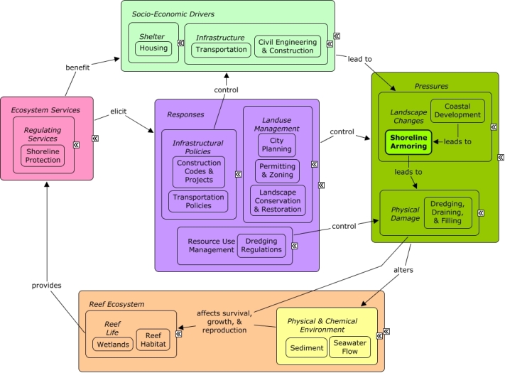
Coastal development is driven by population growth and the need for housing and infrastructure that depend on civil engineering & construction, as well as transportation projects. Coastal development may require stabilization of the shoreline through shoreline armoring or dredging activities, which can directly impact coastal wetlands, alter patterns of water flow, and deposit sediments. Wetlands and reefs may reduce the need for shoreline armoring through wave energy attenuation and shoreline stabilization that reduces flooding, erosion, and protects the shoreline. Construction codes & regulations, transportation policies, landuse management, and dredging regulations through planning, permitting, and zoning can influence intensity and distribution of shoreline armoring. Landuse restoration, such as establishing natural vegetation, can reduce the need for shoreline armoring.Citations
| Citation | Year | Study Location | Study Type | Database Topics |
|---|---|---|---|---|
| Yang, R. Y., Y. C. Wu, H. H. Hwung, J. Y. Liou, and I. V. Shugan. 2010. Current countermeasure of beach erosion control and its application in Taiwan. Ocean and Coastal Management 53:552-561. | 2010 | Taiwan | Field Study & Monitoring | Beaches & Nature Parks; Infrastructure; Shoreline Armoring; Shoreline Protection; Tourism & Recreation |
| Cazes-Duvat, V. 2005. West Indies archipelagos coping with coastal erosion (Macarena, Seychelles and Maldives) [Les archipels de l'ouest de l'ocean Indien face à l'erosion cotiere (Mascareignes, Seychelles, Maldives)]. Annales de Geographie 114:342-361. | 2005 | Seychelles; Maldives | Hotel & Food Services; Shoreline Armoring; Shoreline Protection; Tourism & Recreation; Water Depth & Sea Level | |
| Harris, L. E. 2003. Submerged reef structures for beach erosion control. Pages 1155-1163 in Coastal Structures 2003 - Proceedings of the Conference. | 2003 | Artificial Habitat; Shoreline Armoring; Shoreline Protection | ||
| LeDrew Ellsworth, F., MI KE Wulder, and HE AT HE R Holden. 2000. Change detection of satellite imagery for reconnaissance of stressed tropical corals. Pages 2678-2680 in International Geoscience and Remote Sensing Symposium (IGARSS). | 2000 | Fiji | Remote Sensing; Decision Support Frameworks & Tools | Algae; Finfish Harvest; Mineral, Rock, & Metal Mining; Mining Policies; Shoreline Armoring; Storms & Hurricanes; Surface & Groundwater Flow |
| Connell, S. D. and T. M. Glasby. 1999. Do urban structures influence local abundance and diversity of subtidal epibiota? A case study from Sydney Harbour, Australia. Marine Environmental Research 47:373-387. | 1999 | Australia | Algae; Artificial Habitat; Coralline Algae; Docks & Marinas; Shoreline Armoring | |
| Glasby, T. M. and S. D. Connell. 1999. Urban structures as marine habitats. Ambio 28:595-598. | 1999 | Docks & Marinas; Shoreline Armoring | ||
| Cecich, V., L. Gonzales, A. Hoisaeter, J. Williams, and K. Reddy. 1996. Use of shredded tires as lightweight backfill material for retaining structures. Waste Management and Research 14:433-451. | 1996 | Field Study & Monitoring; Lab Study | Civil Engineering & Construction; Land-Based Civil Engineering; Shoreline Armoring; Solid Waste Disposal; Waste Management; Waste Management Policies | |
| Harris Lee, E., J. Mostkoff Benjamin, and GE RA LD Zadikoff. 1996. Artificial reefs: from waste to resources. Pages 754-759 in Oceans Conference Record (IEEE). | 1996 | Field Study & Monitoring | Artificial Habitat; Biological Monitoring, Mapping, & Scientific Research; Complex Habitat & Resources; Environmental Monitoring, Mapping, & Scientific Research; Finfish Harvest; Housing; Shoreline Armoring; Tourism & Recreation | |
| Cambers, G. 1987. A programme for beach erosion control in Barbados, West Indies. Pages ChiOceanPress-1987 in IN: 1987 PROC. COASTAL & PORT ENGINEERING IN DEVELOPING COUNTRIES, SECOND INT. CONF., (BEIJING, CHINA: SEP. 7-11, 1987). | 1987 | South & Central America; China; Caribbean | Shoreline Armoring; Shoreline Protection; Tourism & Recreation | |
| Fulford, E. T. 1985. Reef type breakwaters for shoreline stabilization. Pages Am.Soc.Civ.Engrs.-1985 in IN: COASTAL ZONE'85, PROC. FOURTH SYMP. ON COASTAL & OCEAN MANAGEMENT, (BALTIMORE, U.S.A.: JUL. 30-AUG. 2, 1985), O.T. MAGOON. | 1985 | Shoreline Armoring; Shoreline Protection | ||
| Spadoni, RI CH AR D and TH OM AS Campbell. 1980. Coral Reef Protection During Beach Restoration In Florida. Pages 152-159 in Proceedings of SOUTHEASTCON Region 3 Conference. | 1980 | Florida | Field Study & Monitoring | Beaches & Nature Parks; Dredging, Draining, & Filling; Environmental Monitoring, Mapping, & Scientific Research; Shoreline Armoring; Shoreline Protection |
| Carlton, J. M. 1974. Land-building and stabilization by mangroves. Environmental Conservation 1:285-294. | 1974 | Florida | Field Study & Monitoring; Lab Study | Beach & Land Formation; Beaches & Nature Parks; Housing; Mangroves; Sediment; Shoreline Armoring; Substrate |
Management Options
| Management Option | Description | Sources | Database Topics |
|---|---|---|---|
| Damage Assessment, Documentation & Response: Respond to Natural Resource Injuries from Coastal Construction & Development | This involves assessing coral, seagrass, and hard bottom substrate that is impacted during coastal construction repair or alternation. If unacceptable damages are occurring this information will be useful in future permit decision making. If infringements have occurred, this information may be useful for compensatory mitigation and liability for restoration of those natural resources injured. | NOAA Marine Sanctuary Program. 2007. Florida Keys National Marine Sanctuary revised management plan. National Ocean Service, Key West, FL. |
Biological Monitoring & Restoration; Civil Engineering & Construction; Coastal Development; Coastal Engineering; Construction Codes & Projects; Docks & Marinas; Dredging Regulations; Dredging, Draining, & Filling; Ecosystem Monitoring & Restoration; Environmental Monitoring & Restoration; Impervious Surfaces; Infrastructural Policies; Infrastructure; Land-Based Civil Engineering; Landscape Changes; Mangroves; Mitigation; Permitting & Zoning; Physical Damage; Physical Variables; Ports & Harbors; Reef Habitat; Remediation; Resource Use Management; Seagrasses; Shoreline Armoring; Special Use Permitting; Utilities; Utility Line Construction & Maintenance; Wetland & Reef Restoration; Wetlands |
| Monitor & Research: Research Historical Hydrology | This activity involves a historical assessment of the hydrology of the surrounding water area around the sanctuary as it has affected water quality and biological communities within the sanctuary. It will clarify the role of freshwater inflows and water quality from local freshwater bodies. Also, this activity will examine the effects of structural modification and changes in quality, quantity, timing and distribution of freshwater releases from existing structures and will examine land-based practices affecting the water quality of runoff. | NOAA Marine Sanctuary Program. 2007. Florida Keys National Marine Sanctuary revised management plan. National Ocean Service, Key West, FL. |
Applied Chemicals; Chemical Variables; Coastal Development; Coastal Engineering; Dam Construction & Maintenance; Deforestation & Devegetation; Discharge Limitations; Discharges; Ditching & Soil Disturbance; Dredging, Draining, & Filling; Ecosystem Monitoring & Restoration; Environmental Monitoring & Restoration; Environmental Monitoring, Mapping, & Scientific Research; Hydrologic Management; Impervious Surfaces; Infrastructural Policies; Landscape Changes; Landuse Management; Physical Variables; Salinity; Seawater Flow; Shoreline Armoring; Stormwater Management; Surface & Groundwater Flow; Water; Water Depth & Sea Level; Water Transportation; Waterborne Discharges |
| Restoration: Beach Renourishment and Nourishment | Beaches are subject to natural accretion and erosion. Tourism is often best supported by wide, accessible, public sandy beaches. Beaches can be restored to counteract natural erosion by transporting large quantities of sand onto the beach. This sand often comes from nearby dredging. Caution should be used when restoring long sections of beaches, as often the area above the mean high tide line is littoral, or privately owned, and restoration of these beaches can impact these property rights, see "Stop the Beach Renourishment, Inc. v. Florida Department of Environmental Protection (2010) U.S. Supreme Court decision." Beach protection or nourishment offers an alternative to this often expensive and abrupt type of renourishment, nourishment involves practices which encourage coastal accretion and discourage erosional forces. See "Florida's Beach and Shore Preservation Act" for some restrictions on this. | NOAA Coastal Services Center. Beach Nourishment: A Guide for Local Government Officials. Coastal Services Center Accessed 6/17/2011. |
Beach & Land Formation; Beaches & Nature Parks; Culture; Dredging, Draining, & Filling; Environmental Monitoring & Restoration; Landscape Conservation & Restoration; Recreational Opportunities; Shoreline Armoring; Shoreline Protection; Sunscreen Use; Tourism & Recreation |
| Stormwater BMPs: Structural Stormwater Retention/Detention | This method attempts to reduce the negative impacts of stormwater runoff through implementation of engineering structures that retain runoff water for further treatment or controlled release. Water collection can be selective, targeting the first flush of water, which is typically the most polluted. Water retention has the additional benefit of later release at a place and time when the water is needed (e.g. for irrigation). Rainwater Collection Systems (#11) can be an important water resource in areas where freshwater is limited. | Natural Resources Conservation Service. 2011. National Handbook of Conservation Practices. U.S. Department of Agriculture. Natural Resources Conservation Service. Combined Infiltration/Detention Basin. Urban BMP's - Water Runoff Management Accessed 3/23/2011. Natural Resources Conservation Service. Detention Devices for Dry/Wet Ponds. Urban BMP's - Water Runoff Management Accessed 3/23/2011. Natural Resources Conservation Service. Dry Extended Detention Ponds. Urban BMP's - Water Runoff Management Accessed 3/23/2011. Leisenring, M., Clary, J., Stephenson, J., and Hobson, P. 2010. International Stormwater Best Management Practices (BMP) Database Pollutant Category Summary: Nutrients. Geosyntec Consultants, Inc. Poresky, A., Clary, J., Strecker, E., and Earles, A. 2011. International Stormwater Best Management Practices (BMP) Database. Technical Summary: Volume Reduction. Geosyntec Consultants. Natural Resources Conservation Service. 2010. Stormwater Runoff Controls. U.S. Depatrment of Agriculture. Natural Resources Conservation Service. 2008. Water and Sediment Control Basin. CODE 638. U.S. Depatrment of Agriculture. Natural Resources Conservation Service. Water Volume Management. Urban BMP's - Water Runoff Management Accessed 3/25/2011. |
Agriculture, Aquaculture, & Forestry Policies; Applied Chemicals; Chemical Variables; City Planning; Civil Engineering & Construction; Climate; Coastal Development; Construction Codes & Projects; Deforestation & Devegetation; Discharge Limitations; Discharges; Ditching & Soil Disturbance; Hydrologic Management; Impervious Surfaces; Infrastructural Policies; Infrastructure; Land-Based Civil Engineering; Landscape Changes; Landuse Management; Non-point Source Controls; Non-point Source Runoff; Physical Variables; Point Source Discharges; Sediment; Shoreline Armoring; Storms & Hurricanes; Stormwater Management; Substrate; Surface & Groundwater Flow; Utilities; Utility Policies; Waste Management; Waste Management Policies; Wastewater Discharge; Water; Waterborne Discharges |
| Waterway Management: Manage Canal Water Quality | This management option addresses water quality issues that may arise from nearshore, confined areas, specifically dead-end canals. This management response does not focus on wastewater discharges into canals, but instead on the hydrologic structure and orientation of the canal itself. Physical problems with canal orientation can lead to such problems as low flushing and build-up of weed wrack. This is a problem because the build-up of weed wrack consumes oxygen and releases nutrients as it decays. When combined with low flushing and circulation, dead end canals have decreased oxygen concentrations, accelerated eutrophication, and accumulate organic materials, pollutants and sediment. To improve the current canal system, management can inventory and map canals to identify high risk hotspots and candidates for future canal restoration projects. Canals are typically constructed to best suit the water access needs of local homes and businesses. Preventing high risk canals from being constructed, or placing certain requirements on their construction through permitting is one way to reduce future problem spots. Some design strategies include: Construct non-linear canals without right-angles and flared inlets oriented to prevailing winds. Instead of dead-ends, canals should include a flow through water exchange system or install mechanical pumps. Canals should be as wide as possible in relation to depth and length. Canal depth should be uniform or progressively shallower away from the parent waterbody, with sloping banks (eliminate requirements for navigable depths to shoreline). Some canal improvement strategies include: Implement weed gates, air curtains, and aeration systems. Direct all stormwater and effluent away from canal systems. Reduce bulkheading and restore native vegetative buffers (#1). Promote diversity of substrates and habitats. | NOAA Marine Sanctuary Program. 2007. Florida Keys National Marine Sanctuary revised management plan. National Ocean Service, Key West, FL. |
Applied Chemicals; Biological Monitoring & Restoration; Boat Movement; Boating Activities; Building & Home Construction; Chemical Variables; City Planning; Civil Engineering & Construction; Coastal Development; Coastal Engineering; Construction Codes & Projects; Decision Support; Deforestation & Devegetation; Discharge Limitations; Discharges; Ditching & Soil Disturbance; Docks & Marinas; Ecosystem Monitoring & Restoration; Environmental Monitoring & Restoration; Fishing Sector; Food & Energy Policies; Hydrologic Management; Improved Technology; Infrastructural Policies; Infrastructure; Land-Based Civil Engineering; Landscape Changes; Landscaping & Household Services; Landuse Management; Non-point Source Controls; Non-point Source Runoff; Nutrient & Contaminant Processing; Physical & Chemical Water Quality Criteria; Physical Damage; Physical Variables; Point & Mobile Source Controls; Point Source Discharges; Ports & Harbors; Provisioning Services; Regulating Services; Seawater Flow; Shoreline Armoring; Shoreline Protection; Small Boats; Surface & Groundwater Flow; Tourism & Recreation; Transportation; Transportation Policies; Utilities; Utility Policies; Waste Management; Waste Management Policies; Wastewater Discharge; Water; Water Depth & Sea Level; Water Resources; Water Transportation; Waterborne Discharges; Wetland & Reef Restoration; Wetlands |
Laws
| Legal Citation | Purpose of Law | Management Organization | Database Topics |
|---|---|---|---|
| Chapter 13: Environmental protection, 12 Virgin Islands Code. | Establishes an environmental protection program for land development to prevent soil erosion and for the conservation of beaches, shorelines, and the coastal zone of USVI. Rules and Regulations were to prevent improper development of land and harmful environmental changes. Application to Coral Reefs:The Earth Change Plan review will indicate any adverse environmental impacts, including those that could effect coral reefs such as sedimentation. Legislative Actions:The law requires an "Earth Change Plan" from the Department of Planning and Natural Resources before any land can be cleared, graded, filled, or otherwise disturbed. Violation from the approved Earth Change Plan is punishable by a fine of $200 per day per violation. Violation of other portions of the Chapter is punishable by $5,000 fine or one year imprisionment per violation. Development in the first tierof the coastal zone requires a coastal zone permit. Comments:Chapter 13 includes comprehensive erosion and sediment control measures applicable to public and private developments including construction and maintenance of streets and roads. |
US Virgin Islands, Department of Planning and Natural Resources, Division of Environmental Protection Jurisdiction: US Virgin Islands |
Building & Home Construction; City Planning; Coastal Development; Complex Habitat & Resources; Construction Codes & Projects; Ditching & Soil Disturbance; Docks & Marinas; Landuse Management; Resource Use Management; Shoreline Armoring |
| Chapter 21: Virgin Islands coastal zone management, 12 Virgin Islands Code. | Protect, maintain, preserve and, where feasible, enhance and restore, the overall quality of the environment in the coastal zone, the natural and man-made resources therein, and the scenic and historic resources of the coastal zone for he benefit of residents of and visitors of the USVI Application to Coral Reefs:The Legislature stated coastal zone protection will conserve ecologically significant resource areas for their contribution to marine productivity and value as wildlife habitats, and preserve the function and integrity of reefs, marine meadows, salt ponds, mangroves and other significant natural areas. The legislation will also maintain or increase coastal water quality through control of erosion, sedimentation, runoff, siltation and sewage discharge. Legislative Actions:Any violation of the chapter will be grounds for revocation or suspension of coastal zone permit and an order to cease and desist. Any person who violates any provision of the chapter shall be subject to a civil fine not to exceed $10,000 per day. Exemplary damages may be assessed at the discretion of the court. Comments:Section 908 of the law shows Coastal Zone Boundaries. Section 909 shows areas of special concern. |
US Virgin Islands, Department of Planning and Natural Resources, Division of Environmental Protection Jurisdiction: US Virgin Islands |
Coastal Development; Coastal Engineering; Construction Codes & Projects; Dredging Regulations; Mangroves; Marine Protected Areas; Resource Use Management; Seagrasses; Shoreline Armoring |
| Coastal Zone Management Act of 1972, as amended through 2004,. | A voluntary national program to encourage coastal states to develop and implement coastal zone management plans and requires that "any federal activity within or outside of the coastal zone that affects any land or water use or natural resource of the coastal zone" shall be "consistent to the maximum extent practicable with the enforceable policies" of a state's coastal zone management plan. The law includes an Enhancement Grants program for protecting, restoring, or enhancing existing coastal wetlands or creating new coastal wetlands. It also establishes the National Estuarine Research Reserve System, guidelines for estuarine research, and financial assistance for land acquisition. Application to Coral Reefs:Protection of coastal areas can have an indirect influence on coral reef preservation and conservation by the use of environmentally sound construction and development by limiting runoff of contaminants and sediment that could have an adverse effect on inshore coral reefs if present. Legislative Actions:The 1985 amendments (PL 99-272) established the National Estuarine Reserve Research System a State-Federal process for designating national reserves and guidelines for estuarine research.The 1990 amendments (PL 101-508) established new Enhancement Grants for eight specific areas, including protecting, restoring or enhancing existing coastal wetlands or creating new coastal wetlands and assessing the cumulative effects of coastal development on coastal wetlands and fishery resource. Also, the 1990 statute established a new Coastal Nonpoint Source Pollution Control Program. The 1998 and 2004 (PL 105-383 and PL 108-456) established a program for the prevention and control of harmful algal blooms and hypoxia, and included authorization for a representative of the Department of Interior to assess the economic and ecological impacts of algal blooms and hypoxia. Comments:If implemented, the programs for economic, ecological and control of harmful algal blooms and hypoxia would be useful for coral reef issues. |
National Oceanic and Atmospheric Administration/US Fish and Wildlife Service Jurisdiction: United States |
Building & Home Construction; City Planning; Civil Engineering & Construction; Coastal Development; Construction Codes & Projects; Docks & Marinas; Economic Markets & Policies; Infrastructural Policies; Mangroves; Permitting & Zoning; Ports & Harbors; Seagrasses; Shoreline Armoring; Surface & Groundwater Flow |
| Delineation of the landward extent of wetlands and surface waters, 62-340 Florida Administrative Code Annotated (2000). | The Rule's intent is to provide a unified statewide methodology for the delineation of the extent of wetlands to satisfy the mandate of Section 373.421, F. S. Application to Coral Reefs:Preservation of wetlands will allow them to continue to function as buffers for sediment and contaminant control keeping them from reaching estuarine and marine waters and eventually habitats including coral reefs. Legislative Actions:The Rule is administrative and methodological for delineation purposes. Comments: |
Florida Department of Environmental Protection Jurisdiction: State Coastal Waters; US State Waters; Designated Marine Areas |
Agriculture, Aquaculture, & Forestry Policies; Coastal Development; Dam Construction & Maintenance; Docks & Marinas; Dredging Regulations; Drinking Water Supply; Energy Policy & Development; Finfish & Shellfish Stock; Fish; Invertebrates; Landuse Management; Molluscs; Pipelines; Ports & Harbors; Road Construction & Maintenance; Sediment; Sewage Treatment; Shoreline Armoring; Small Boats; Solid Waste Disposal; Utility Line Construction & Maintenance; Wetlands |
| General permit for activities seaward of the coastal construction control line, 62B-34 Florida Administrative Code Annotated (2010). | To implement the provisions of Section 161.053(19) F. S. providing General Permits for activities performed seaward of the Coastal Construction Control line. Persons wishing to use one or more of the General Permits as set forth in Part II of this rule chapter shall be subject to the notice provisions of subsection 62B-34.030(4) F. A. C. before any activity is conducted as authorized herein.The general conditions provided pursuant to Section 62-B34-0.50, F. A. C. , shall apply to all of the General Permits issued under this rule chapter. Strict compliance with all of the terms, conditions, requirements, limitations, and restrictions applicable to a desired General Permit under this rule chapter is required to qualify for such a permit. Application to Coral Reefs:The rule requires erosion control BMP. Therefore, sediment from construction will not enter the marine environment and damage coral reefs. Legislative Actions:Civil fines are applicable for work done that was not authorized in the permit. Comments: |
Florida Departrment of Environmental Protection Jurisdiction: State Coastal Waters |
Beaches & Nature Parks; Coastal Defense; Coastal Development; Coastal Engineering; Complex Habitat & Resources; Construction Codes & Projects; Docks & Marinas; Dredging, Draining, & Filling; Landscape Conservation & Restoration; Landuse Management; Mangroves; Ports & Harbors; Resource Use Management; Seagrasses; Sediment; Shoreline Armoring |
| Joint Coastal Permits and Concurrent Processing of Proprietary Authorizations, 62B-049 Florida Administrative Code. | This chapter implements the provisions of Section 161.055, F.S., by combining the regulatory requirements of the coastal construction program (Section 161.041, F.S.) with the environmental resource (or wetland resource) permit program (Part IV of Chapter 373, F.S.) to establish the joint coastal permit program. Activities that would have required both a coastal construction permit and an environmental resource (or wetland resource) permit, are now authorized by a single joint coastal permit. In addition, this chapter provides for concurrent review of any activity requiring a joint coastal permit that also requires a proprietary authorization for use of sovereign submerged lands owned by the Board of Trustees of the Internal Improvement Trust Fund. This chapter also establishes procedures for processing applications for joint coastal permits and the linked proprietary authorizations. In the event that there is a conflict between the procedural requirements of this chapter and other procedural rules promulgated pursuant to the referenced statutes, then this chapter shall govern. The standards and criteria for issuance of joint coastal permits include the criteria for environmental resource or wetland resource permits pursuant to Chapter 62-312, F.A.C., and the rules adopted under Chapter 62-330, F.A.C., the coastal construction criteria pursuant to Chapter 62B-41, F.A.C., and any specific criteria for issuance of a joint coastal permit listed in this chapter. The criteria for the associated proprietary authorizations are found in Chapters 18-18, 18-20, 18-21, F.A.C.
Specific Authority 161.055, 373.427 FS. Law Implemented 161.041, 161.055, 373.427 FS. History�New 10-12-95, Amended 2-19-98, 5-17-07. Application to Coral Reefs:Requiring a permit with regulatory review of the construction project, in a joint review of wetland and submerged land issues, will assist in minimizing potential adverse environmental impacts from the work and such potential detrimental portions of the project (e.g. sedimentation) will not enter the marine environment resulting in ecosystem damage. Legislative Actions: Comments:This chapter implements the provisions of Section 161.055, F.S., by combining the regulatory requirements of the coastal construction program (Section 161.041, F.S.) with the environmental resource (or wetland resource) permit program (Part IV of Chapter 373, F.S.) to establish the joint coastal permit program. Activities that would have required both a coastal construction permit and an environmental resource (or wetland resource) permit, are now authorized by a single joint coastal permit. In addition, this chapter provides for concurrent review of any activity requiring a joint coastal permit that also requires a proprietary authorization for use of sovereign submerged lands owned by the Board of Trustees of the Internal Improvement Trust Fund. This chapter also establishes procedures for processing applications for joint coastal permits and the linked proprietary authorizations. |
Florida State Department of Environmental Protection Jurisdiction: State Coastal Waters |
Building & Home Construction; Coastal Development; Docks & Marinas; Mangroves; Ports & Harbors; Resource Use Management; Seagrasses; Shoreline Armoring; Shoreline Protection |
| Mitigation Banking, 62-342 Florida Administrative Code. | (1) The Department recognizes that, in certain instances, adverse impacts of activities regulated under Part IV of Chapter 373, F.S., can be offset through the utilization of mitigation credits from a permitted Mitigation Bank. This rule provides criteria for this mitigation alternative to complement existing mitigation criteria and requirements. This chapter is supplemental to and does not supersede any other criteria and requirements in rules promulgated under Part IV of Chapter 373, F.S.
(2) The Department intends that Mitigation Banks be used to minimize mitigation uncertainty associated with traditional mitigation practices and provide greater assurance of mitigation success. It is anticipated that the consolidation of multiple mitigation projects into larger contiguous areas will provide greater assurance that the mitigation will yield long-term, sustainable, regional ecological benefits. Mitigation Banks shall be consistent with Department endorsed watershed management objectives and emphasize restoration and enhancement of degraded ecosystems and the preservation of uplands and wetlands as intact ecosystems rather than alteration of landscapes to create wetlands. This is best accomplished through restoration of ecological communities that were historically present. The establishment and use of Mitigation Banks in or adjacent to areas of national, state, or regional ecological significance is encouraged, provided the area in which the Mitigation Bank is proposed to be located is determined appropriate for a Mitigation Bank and the Mitigation Bank meets all applicable permitting criteria.
(3) Nothing in this chapter shall affect the mitigation requirements set forth in any Mitigation Bank agreement or any permit issued under Chapter 84-79, Laws of Florida, or Part IV of Chapter 373, F.S., prior to February 2, 1994. If a permittee wishes to substantially modify a Mitigation Bank previously established by agreement or permit, the permittee must comply with this chapter. Additionally, some Mitigation Banks may be subject to the version of this section existing prior to July 1, 1996, under subsections 373.4136(9) and (10), F.S., and will not be affected by amendments adopted after that date. This chapter does not prohibit an applicant from proposing project-specific, pre-construction on-site or off-site mitigation, without establishing a Mitigation Bank. Application to Coral Reefs:Mitigation banking in coastal wetlands, as presented in the Chapter, can provide large areas of functioning wetlands. The wetlands can function as sediment and nutrient traps keeping sediment and nutrients from entering coastal waters and damaging marine ecosystems including coral reefs. Legislative Actions: Comments:Establishes the regulations and permitting requirements for mitigation banks. |
Florida State Department of Environmental Protection Jurisdiction: US State Waters |
Biological Monitoring & Restoration; Building & Home Construction; Coastal Development; Construction Codes & Projects; Docks & Marinas; Educational & Research Opportunities; Nutrient & Contaminant Processing; Ports & Harbors; Shoreline Armoring; Waste Management Policies |
| Rules and Procedures for Coastal Construction and Excavation, 62B-033 Florida Administrative Code (2008). | (1) The beach and dune system is an integral part of the coastal system and represents one of the most valuable natural resources in Florida, providing protection to adjacent upland properties, recreational areas, and habitat for wildlife. A coastal construction control line (CCCL) is intended to define that portion of the beach and dune system which is subject to severe fluctuations caused by a 100-year storm surge, storm waves, or other forces such as wind, wave, or water level changes. These fluctuations are a necessary part of the natural functioning of the coastal system and are essential to post-storm recovery, long term stability, and the preservation of the beach and dune system. However, imprudent human activities can adversely interfere with these natural processes and alter the integrity and functioning of the beach and dune system. The control line and 50-foot setback call attention to the special hazards and impacts associated with the use of such property, but do not preclude all development or alteration of coastal property seaward of such lines.
(2) In order to demonstrate that construction is eligible for a permit, the applicant shall provide the Department with sufficient information pertaining to the proposed project to show that adverse and other impacts associated with the construction have been minimized and that the construction will not result in a significant adverse impact.
(3) After reviewing all information required pursuant to this rule chapter, the Department shall:
(a) Deny any application for an activity which either individually or cumulatively would result in a significant adverse impact including potential cumulative effects. In assessing the cumulative effects of a proposed activity, the Department shall consider the short-term and long-term impacts and the direct and indirect impacts the activity would cause in combination with existing structures in the area and any other similar activities already permitted or for which a permit application is pending within the same fixed coastal cell. The impact assessment shall include the anticipated effects of the construction on the coastal system and marine turtles. Each application shall be evaluated on its own merits in making a permit decision; therefore, a decision by the Department to grant a permit shall not constitute a commitment to permit additional similar construction within the same fixed coastal cell.
(b) Deny any application for an activity where the project has not met the Department�s siting and design criteria; has not minimized adverse and other impacts, including stormwater runoff; or has not provided mitigation of adverse impacts.
(4) The Department shall issue a permit for construction which an applicant has shown to be clearly justified by demonstrating that all standards, guidelines, and other requirements set forth in the applicable provisions of Part I, Chapter 161, F.S., and this rule chapter are met, including the following:
(a) The construction will not result in removal or destruction of native vegetation which will either destabilize a frontal, primary, or significant dune or cause a significant adverse impact to the beach and dune system due to increased erosion by wind or water;
(b) The construction will not result in removal or disturbance of in situ sandy soils of the beach and dune system to such a degree that a significant adverse impact to the beach and dune system would result from either reducing the existing ability of the system to resist erosion during a storm or lowering existing levels of storm protection to upland properties and structures;
(c) The construction will not direct discharges of water or other fluids in a seaward direction and in a manner that would result in significant adverse impacts. Forthe purposes of this rule section, construction shall be designed so as to minimize erosion induced surface water runoff within the beach and dune system and to prevent additional seaward or off-site discharges associated with a coastal storm event.
(d) The construction will not result in the net excavation of the in situ sandy soils seaward of the control line or 50-foot setback;
(e) The construction will not cause an increase in structure-induced scour of such magnitude during a storm that the structure-induced scour would result in a significant adverse impact;
(f) The construction will minimize the potential for wind and waterborne missiles during a storm;
(g) The activity will not interfere with public access, as defined in Section 161.021, F.S.; and
(h) The construction will not cause a significant adverse impact to marine turtles, or the coastal system.
(5) In order for a manmade frontal dune to be considered as a frontal dune defined under Section 161.053(6)(a)1., F.S., the manmade frontal dune shall be constructed to meet or exceed the protective value afforded by the natural frontal dune system in the immediate area of the subject shoreline. Prior to the issuance of a permit for a single-family dwelling meeting the criteria of Section 161.053(6)(c), F.S., the manmade frontal dune must be maintained for a minimum of 12 months and be demonstrated to be as stable and sustainable as the natural frontal dune system.
(6) Sandy material excavated seaward of the control line or 50-foot setback shall be maintained on site seaward of the control line or 50-foot setback and be placed in the immediate area of construction unless otherwise specifically authorized by the Department.
(7) Swimming pools, wading pools, waterfalls, spas, or similar type water structures are expendable structures and shall be sited so that their failure does not have adverse impact on the beach and dune system, any adjoining major structures, or any coastal protection structure. Pools sited within close proximity to a significant dune shall be elevated either partially or totally above the original grade to minimize excavation and shall not cause a net loss of material from the immediate area of the pool. All pools shall be designed to minimize any permanent excavation seaward of the CCCL.
(8) Major structures shall be located a sufficient distance landward of the beach and frontal dune to permit natural shoreline fluctuations, to preserve and protect beach and dune system stability, and to allow natural recovery to occur following storm-induced erosion. Where a rigid coastal structure exists, proposed major structures shall be located a sufficient distance landward of the rigid coastal structure to allow for future maintenance or repair of the rigid coastal structure. Although fishing piers shall be exempt from this provision, their foundation piles shall be located so as to allow for the maintenance and repair of any rigid coastal structure that is located in close proximity to the pier.(9) If in the immediate area a number of existing major structures have established a reasonably continuous and uniform construction line and if the existing structures have not been unduly affected by erosion, except where not allowed by the requirements of Section 161.053(6), F.S., and this rule chapter, the Department shall issue a permit for the construction of a similar structure up to that line.
(10) In considering applications for single-family dwellings proposed to be located seaward of the 30-year erosion projection pursuant to Section 161.053(6), F.S., the Department shall require structures to meet criteria in Section 161.053(6)(c), F.S., and all other siting and design criteria established in this rule chapter.
(11) In considering project impacts to native salt-tolerant vegetation, the Department shall evaluate the type and extent of native salt-tolerant vegetation, the degree and extent of disturbance by invasive nuisance species and mechanical and other activities, the protective value to adjacent structures and natural plant communities, the protective value to the beach and dune system, and the impacts to marine turtle nesting and hatchlings. The Department shall restrict activities that lower the protective value of natural and intact beach and dune, coastal strand, and maritime hammock plant communities. Activities that result in the removal of protective root systems or reduce the vegetation�s sand trapping and stabilizing properties of salt tolerant vegetation are considered to lower its protective value. Construction shall be located, where practicable, in previously disturbed areas or areas with non-native vegetation in lieu of areas of native plant communities when the placement does not increase adverse impact to the beach and dune system. Planting of invasive nuisance plants, such as those listed in the Florida Exotic Pest Plant Council�s 2005 List of Invasive Species � Categories I and II, will not be authorized if the planting will result in removal or destruction of existing dune-stabilizing native vegetation or if the planting is to occur on or seaward of the dune system. A copy of this list is available on the Internet at www.fleppc.org; or can be obtained by writing to the Department of Environmental Protection, Bureau of Beaches and Coastal Systems, 3900 Commonwealth Boulevard, Mail Station 300, Tallahassee, Florida 32399-3000; or by telephoning (850) 488-7708. Special conditions relative to the nature, timing, and sequence of construction and the remediation of construction impacts shall be placed on permitted activities when necessary to protect native salt-tolerant vegetation and native plant communities. A construction fence, a designated location for construction access or storage of equipment and materials, and a restoration plan shall be required if necessary for protection of existing native salt-tolerant vegetation during construction.
(12) Special conditions relative to the nature, timing, and sequence of construction shall be placed on permitted activities when necessary to protect marine turtles and their nests and nesting habitat. In marine turtle nesting areas, all forms of lighting shall be shielded or otherwise designed so as not to disturb marine turtles. Tinted glass or similar light control measures shall be used for windows and doors which are visible from the nesting areas of the beach. The Department shall suspend any permitted construction when the permittee has not provided the required protection for marine turtles and their nests and nesting habitat. Application to Coral Reefs:Regulation of coastal construction through permit review and modification will protect coastal ecosystems from degradation and loss and in doing so protects other marine ecosystems including coral reefs. Legislative Actions:Chapter 62B-33 Florida Administrative Code, provides the design and siting requirements that must be met to obtain a coastal construction control line permit.Approval or denial of a permit application is based upon a review of the potential impacts to the beach dune system, adjacentproperties, native salt resistant vegetation, and marine turtles. Comments:The Coastal Construction Control Line (CCCL) is an essential element of Florida's coastal management program. It provides protection for Florida's beaches and dunes while assuring reasonable use of private property. Recognizing the value of the state's beaches, the Florida legislature initiated the Coastal Construction Contorl Line Program to protect the coastal system from improperly sited and designed structures which can destabilize or destroy the beach and dune system. Once destabilized, the valuable natural resources are lost, as are its important values for recreation, upland property protection and environmental habitat. Adoption of a coastal construction line establishes an area of jurisdiction in which special siting and design criteria are applied for construction and related activities.These standards may be more stringent than those already applied in the rest of the coastal building zone because of the greater forces expected to occur in the more seaward zone of the beach during a storm event. |
Florida State Department of Environmental Protection Jurisdiction: State Coastal Waters; Designated Marine Areas |
Beach & Land Formation; Building & Home Construction; City Planning; Civil Engineering & Construction; Coastal Development; Construction Codes & Projects; Cruise Ships; Docks & Marinas; Dredging Regulations; Dredging, Draining, & Filling; Hydrologic Management; Landuse Management; Mangroves; Marine Protected Areas; Oil & Gas Tankers; Pipelines; Ports & Harbors; Resource Use Management; Seagrasses; Seawater Flow; Sediment; Shoreline Armoring; Shoreline Protection; Storms & Hurricanes; Tourism & Recreation Policies; Water Depth & Sea Level |
| Surface water quality standards in table format, 62.302.500 Florida Administrative Code Annotated (2008). | This section of Chapter 62-302 presents the water quality standards in a tabular format for each class of waters of the State. Application to Coral Reefs: Legislative Actions: Comments: |
Florida Department of Environmental Protection Jurisdiction: State Coastal Waters; US State Waters |
Agriculture, Aquaculture, & Forestry Policies; Building & Home Construction; Chemical Variables; Coastal Development; Coastal Engineering; Complex Habitat & Resources; Construction Codes & Projects; Dam Construction & Maintenance; Deforestation & Devegetation; Ditching & Soil Disturbance; Docks & Marinas; Finfish & Shellfish Stock; Landuse Management; Mangroves; Permitting & Zoning; Ports & Harbors; Resource Use Management; Road Construction & Maintenance; Seagrasses; Sediment; Shoreline Armoring; Utility Line Construction & Maintenance |
| Surface water quality standards, 62-302 Florida Administrative Code Annotated (2008). | The Chapter establishes the minimum concentrations of contamination that are allowable to protect the designated uses of a waterbody. Designated uses include public drinking water supplies, propagation of fish and wildlife, agricultural, recreation, industrial, and navigation. Application to Coral Reefs:Protecting surface waters by limiting the concentration of pollutants that can be present will control the concentrations of those pollutants that will reach estuarine and marine environments, thus protecting the associated ecosystems, including coral reefs. Legislative Actions:Penalties are not presented in the Rule. Specific requirements and penalties are addrressed in individual permits. The Rule relies heavily on biocriteria including acute toxicity, chronic toxicity, Shannon-Weaver Diversity Index. Section 400 presents the classes of Florida waters; Class I potable water supplies, Class II shellfish propagation or harvesting, Class III recreation, propagation and maintenance of a healthy, well-balanced population of fish and wildlife, Class IV agricultural water supplies, Class V navigation, utility and industrial use. Comments: |
Florida Department of Environmental Protection Jurisdiction: State Coastal Waters; US State Waters; Designated Marine Areas |
Biocriteria; Biological Monitoring, Mapping, & Scientific Research; Civil Engineering & Construction; Coastal Development; Commercial Fisheries; Complex Habitat & Resources; Dam Construction & Maintenance; Deforestation & Devegetation; Designate Protected Species; Discharge Limitations; Dive, Snorkeling, & Swimming Tourism; Docks & Marinas; Dredging Regulations; Dredging, Draining, & Filling; Drinking Water Supply; Fertilizer & Pesticide Use; Finfish & Shellfish Stock; Fish; Fishing & Harvesting Management; Impervious Surfaces; Invertebrates; Irrigation; Landuse Management; Molluscs; Non-point Source Controls; Non-point Source Runoff; Nutrient & Contaminant Processing; Nutrients; Physical & Chemical Water Quality Criteria; Pipelines; Point & Mobile Source Controls; Point Source Discharges; Ports & Harbors; Recreational Fishing; Sediment; Sewage Treatment; Shoreline Armoring; Small Boats; Tourism & Recreation Policies; Toxics; Waste Management Policies |
| Surface waters of the State, Florida Administrative Code Annotated §§ Chapter 62-301 (1996). | It is the intent of this Chapter to define the landward externt of surface waters of the state. Te findings, declarations, and intentfor this Chapter are the same as those for Chapter 62-302 F. A. C. Application to Coral Reefs:By defining the landward extent of surface waters of the State using dominant plant species, the guidance in the Chapter will include wetlands and transitional zones on many occasions. Through the protection of these areas, filtration of sediment and nutrients will be maintained and two of the harmful parameters for coral reefs will be reduced. Legislative Actions:The Chapter is a guidance document and does not contain penalties. The Chapter provides a list of plant species for use with the guidance as well as the methods of calculating the areas of state waters. Comments: |
Florida Department of Environmental Protection Jurisdiction: State Coastal Waters; US State Waters; Designated Marine Areas |
Arthropods; Ballast Discharge; Beaches & Nature Parks; Biotechnology Research & Development; Building & Home Construction; Coastal Development; Docks & Marinas; Dredging Regulations; Dredging, Draining, & Filling; Finfish & Shellfish Stock; Fish; Fishing & Harvesting Management; Forestry; Invertebrates; Landscape Conservation & Restoration; Landuse Management; Mangroves; Marine Birds; Marine Vertebrates; Molluscs; Non-point Source Runoff; Nutrient & Contaminant Processing; Petroleum Spills; Pipelines; Ports & Harbors; Recreational Fishing; Resource Use Management; Sea Turtles; Seagrasses; Sediment; Shoreline Armoring; Small Boats; Surface & Groundwater Flow; Utility Line Construction & Maintenance; Wastewater Discharge; Wetlands; Whales & Dolphins |
| The DPNR states that wetlands in the Virgin Islands are covered by the Clean water Act and the Endangered and Indigenous Species Act of 1990 (Title 12, Chapter 2, US Virgin Island Code,. | To protect wetlands and wetland species from degradation, loss as a result of dredging and filling. Application to Coral Reefs:Protection of wetlands assists in controlling sedimentation and nutrient runoff from terrstrial locations, thus protecting coral reefs that are influenced by terrestrial sources. Legislative Actions: Comments:The wetlands portion of the USVI Division of Environmental Protection website was under construction at the time of this atlas preparation. However, it appears that DEP works with the USACE and USEPA on matters related to wetlands. |
US Virgin Islands, Department of Planning and Natural Resources, Division of Environmental Protection Jurisdiction: US Virgin Islands |
Building & Home Construction; Coastal Development; Coastal Engineering; Construction Codes & Projects; Dredging Regulations; Dredging, Draining, & Filling; Educational & Research Opportunities; Existence Value & Sense of Place; Mangroves; Nutrient & Contaminant Processing; Recreational Opportunities; Resource Use Management; Seagrasses; Shoreline Armoring; Wetlands |
| Total maximum daily loads, 62-304 Florida Administrative Code Annotated (2006). | The Chapter establishes Total Maximum Daily Loads (TMDLs), and their allocations, for waters that have been verified to be impaired by a pollutant pursuant to Chapter 62-303. F.A.C. Application to Coral Reefs:By regulating the amount of pollutants that will be allowed to be discharged into major waterbodies of the state, the amount of pollutants reaching estuarine and then marine environments, and eventually coral reefs, will assist in protecting the reefs and other habitats. Legislative Actions:The planning list of impaired water bodies has been completed. Data on each water bodies has been collected. DEP is in the process of calculating TMDLs for each water body. Comments: |
Florida Department of Envitonmental Protection Jurisdiction: United States; State Coastal Waters |
Agriculture, Aquaculture, & Forestry Policies; Aquaculture; Ballast Discharge; Biomedical Research Policies; Coastal Development; Deforestation & Devegetation; Ditching & Soil Disturbance; Dredging Regulations; Finfish & Shellfish Stock; Impervious Surfaces; Irrigation; Landuse Management; Metals, Electronics, & Machinery Products; Nutrient & Contaminant Processing; Nutrients; Physical & Chemical Water Quality Criteria; Point Source Discharges; Resource Use Management; Sediment; Sewage Treatment; Shoreline Armoring; Solid Waste Disposal; Waste Management Policies; Wastewater Discharge; Wetland & Reef Restoration; Wood, Plastics, & Chemical Products |
| Uniform Mitigation Assessment Method, Florida Administrative Code Annotated §§ Chapter 62-345 (2005). | Establishes a methodology that provides a standard procedure for assessing the functions provided by wetlands and other surface waters, the amount that those functions are reduced by a proposed impact, and the amount of mitigation necessary to offset that loss. Application to Coral Reefs:Protecting wetlands provides wetland areas that can act as buffers against nutrients, pollutants and contaminants from reaching habitats including coral reefs. Legislative Actions:The Chapter is administrative and provides methods to assess wetland value and appropriate mitigation to offset impact. Comments: |
Florida Department of Environmental Protection Jurisdiction: State Coastal Waters |
Agriculture, Aquaculture, & Forestry Policies; Building & Home Construction; Civil Engineering & Construction; Coastal Development; Coastal Engineering; Complex Habitat & Resources; Construction Codes & Projects; Dam Construction & Maintenance; Docks & Marinas; Dredging Regulations; Dredging, Draining, & Filling; Finfish & Shellfish Stock; Forestry; Land-Based Civil Engineering; Landuse Management; Mangroves; Nutrient & Contaminant Processing; Oil & Gas Research & Exploration; Pipelines; Ports & Harbors; Recreational Opportunities; Resource Use Management; Road Construction & Maintenance; Seagrasses; Sediment; Shoreline Armoring; Surface & Groundwater Flow; Utility Line Construction & Maintenance; Wetlands |