ReefLink Database

Sediment
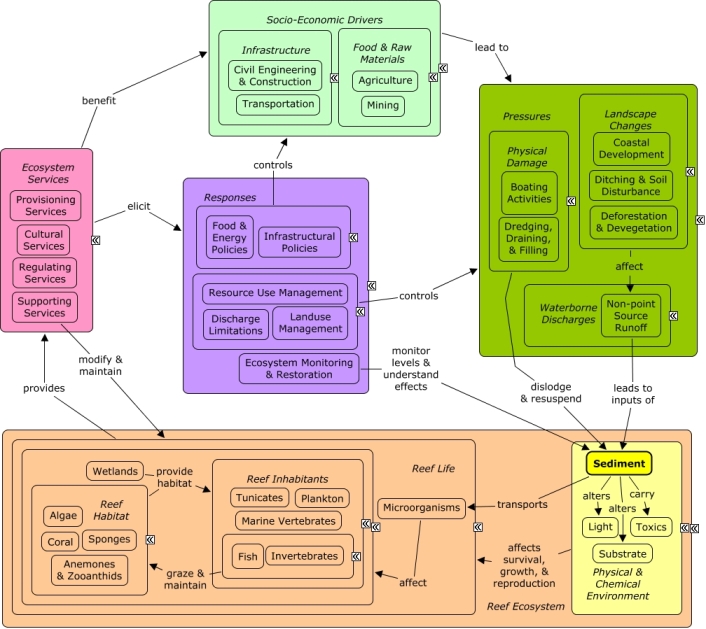
Sediment includes dirt, sand, silt, clay, and small rocks that form soil on land or soft substrate in marine habitats, and may be transported by water, wind, or human activities.
CMap
CMap Description
Human activities that alter the landscape, including devegetation or soil disturbance, can cause sediment run-off into coastal ecosystems. Sediment from terrestrial sources may transport microorganisms to the marine environment. Dredging activities can dislodge large amounts of sediment, often burying marine plants and coral. Movement of boats and ships can cause sediment to be resuspended in the water column, covering coral, affecting light availability, and impacting the behavior of fish and invertebrates. Effects of sediment on reef habitat and inhabitants can impact the availability of ecosystem services. Sediment loading can be monitored and mapped to target sources or vulnerable areas. Remediation activities can be implemented to physically remove sediment. Resource use management, such as boating or dredging regulations, can be established to minimize dislodgement or resuspension of sediment. Landuse management, agricultural practices, or mining practices can be implemented to minimize soil disturbance and devegetation that contribute to sedimentation. Many of the same socio-economic sectors, such as transportation, civil engineering, and construction that create pressures on the reef also benefit from goods and services, such as shoreline protection or recreational opportunities that contribute to the cultural identity of the local community.Citations
More than 50 citations. Click here to load.
| Citation | Year | Study Location | Study Type | Database Topics |
|---|
Management Options
| Management Option | Description | Sources | Database Topics |
|---|---|---|---|
| Agriculture & Aquaculture: Hydroseeding High Risk Soils | Hydroseeding is a process that creates a slurry of seeds, water, and mulch. This slurry can be applied with the use of trucks, trailers, and even aircrafts. This method is particularly useful because it promotes quick germination and reduces erosion. It is especially beneficial to use this method where there is a vastness of bare soil due to clearing vegetation for roads, homes, and farming. Higher elevations are typically steeper and often experience heavy rainfall, and ultimately an extreme amount of erosion occurs if soil is bare. Erosion from the highlands can fill the reservoirs in the drainage basin with sediment. Using hydroseeding would increase vegetation and ultimately the stabilization of the soil. Also, increased vegetation through hydroseeding would help with infiltration rates because the roots would aerate the soil. | Center for Watershed Protection. 2008. Guanica Bay watershed management plan. Natural Resources Conservation Service. 1999. Temporary Seeding. NRCS Planning and Design Manual. U.S. Depatrment of Agriculture. |
Agriculture; Agriculture, Aquaculture, & Forestry Policies; Biological Monitoring & Restoration; Civil Engineering & Construction; Construction Codes & Projects; Deforestation & Devegetation; Ditching & Soil Disturbance; Ecosystem Monitoring & Restoration; Environmental Monitoring & Restoration; Food & Energy Policies; Food & Raw Materials; Forestry; Infrastructure; Land-Based Civil Engineering; Landscape Changes; Landscape Conservation & Restoration; Landuse Management; Mining; Mining Policies; Reef Life; Sediment |
| Agriculture & Aquaculture: Change Agricultural Cover Crop Practices | Cover crop outreach entails changing agricultural practices in an area to leave vegetation and cover on the soil while growing other crops (e.g. Coffee). Agricultural practices that encourage leaving soil bare are extremely susceptible to erosion (e.g. sun grown Coffee). Cover crop methods and shade-grown crops (e.g. shade-grown Coffee) would reduce the large amount of sediment that is eroding, particularly from high elevations, and ultimately will reduce the amount of sediment that reaches the coral reefs. Options to encourage transition to cover crop practices include outreach to raise awareness of benefits and cost share programs to help farmers with the burden of the extra expense. | Center for Watershed Protection. 2008. Guanica Bay watershed management plan. Natural Resources Conservation Service. 2011. National Handbook of Conservation Practices. U.S. Department of Agriculture. Natural Resources Conservation Service. 2010. Conservation Cover. CODE 327. US Department of Agriculture. |
Agriculture; Agriculture, Aquaculture, & Forestry Policies; Applied Chemicals; Collaboration & Partnering; Cultural Policies; Deforestation & Devegetation; Discharges; Ditching & Soil Disturbance; Environmental Education & Outreach; Food & Energy Policies; Food & Raw Materials; Funding & Donations; Landscape Changes; Non-point Source Controls; Non-point Source Runoff; Responses; Sediment |
| Agriculture & Aquaculture: Contour Farming | Contour Farming involves sloping land in such a way that field preparation, planting and cultivating are done on the contour. This includes following established grades of terraces or diversions. During heavy rains the crop rows formed slow water runoff reducing erosion and water runoff of non-point source pollutants such as agricultural herbicides and fertilizers. | Natural Resources Conservation Service. 2011. National Handbook of Conservation Practices. U.S. Department of Agriculture. |
Agriculture; Agriculture, Aquaculture, & Forestry Policies; Applied Chemicals; Discharge Limitations; Ditching & Soil Disturbance; Fertilizer & Pesticide Use; Food & Energy Policies; Food & Raw Materials; Food, Beverage, & Tobacco Products; Landscape Changes; Non-point Source Controls; Non-point Source Runoff; Nutrients; Sediment; Toxics; Waterborne Discharges |
| Agriculture & Aquaculture: Grazing Land Management | This management option protects range, pasture and other types of grazing lands for agricultural animals. Special actions should be taken to protect sensitive areas such as streams, wetlands and estuaries if livestock is to have access to these areas. Grazing management practices can be categorized into four types, vegetative stabilization, grazing management systems, access limitations and alternative water supplies. Vegetative stabilization involves reestablishing the vegetative cover on ranges after it has been removed by grazing to reduce erosion rates. Grazing management systems typically reduce the time livestock spend in each pasture to increase the quantity and quality of vegetation in those pastures. Grazing frequency, timing, duration, area allocation, and livestock distribution kind, class, distribution and stocking rates should all be considered in the management system to ensure adequate pasture rehabilitation. Access limitations, such as fencing and stream crossings are used to herd and control livestock movement. Physical disturbance from livestock can increase erosion, so crossings and watering access points should be hardened. Alternative water supplies are an alternative to more sensitive water sources that may be vulnerable to erosion and discharges from grazing areas. | Environmental Protection Agency Office of Water. 1993. Guidance Specifying Management Measures For Sources Of Nonpoint Pollution In Coastal Waters. EPA/840/B-92/002, US EPA, Washington, DC. Natural Resources Conservation Service. 2011. National Handbook of Conservation Practices. U.S. Department of Agriculture. |
Agriculture; Agriculture, Aquaculture, & Forestry Policies; Deforestation & Devegetation; Discharges; Food & Energy Policies; Food & Raw Materials; Food, Beverage, & Tobacco Products; Landscape Changes; Landuse Management; Non-point Source Controls; Non-point Source Runoff; Nutrients; Physical & Chemical Water Quality Criteria; Sediment; Waterborne Discharges |
| Forestry Policy: Forestry Management Planning | There are many aspects to properly managing forestry sites to reduce point source and non-point source pollutants. Forestry activities can degrade water quality with several types of pollutants and impacts, including: sediment, nutrients, forest chemicals like pesticides, organic debris from tree litter, increased water temperature and increased streamflow. The Forestry management plan and practices include, but are not limited to: pre-harvest planning, road construction and use, prescribed burning and fire management, brush management, timber harvest, regeneration, and application of forest chemicals. Wetlands Forest Management has additional best practices. | Environmental Protection Agency Office of Water. 1993. Guidance Specifying Management Measures For Sources Of Nonpoint Pollution In Coastal Waters. EPA/840/B-92/002, US EPA, Washington, DC. Natural Resources Conservation Service. 2011. National Handbook of Conservation Practices. U.S. Department of Agriculture. |
Agriculture, Aquaculture, & Forestry Policies; Applied Chemicals; Biological Harvest; Chemical Use Regulations; Civil Engineering & Construction; Deforestation & Devegetation; Discharge Limitations; Ditching & Soil Disturbance; Fertilizer & Pesticide Use; Food & Raw Materials; Forestry; Landscape Changes; Landscape Conservation & Restoration; Landuse Management; Manufacturing & Trade; Non-point Source Controls; Non-point Source Runoff; Nutrients; Physical & Chemical Water Quality Criteria; Point & Mobile Source Controls; Point Source Discharges; Regulating Services; Resource Use Management; Sediment; Supporting Services; Surface & Groundwater Flow; Toxics; Waterborne Discharges; Wetlands; Wood, Plastics, & Chemical Products |
| Forestry Policy: Forestry Streamside Management Areas | There are often surface waters, such as streams and lakes, within forestry areas that require special protection. This management option involves establishing and maintaining management areas (35 to 50 feet) around these surface waters to buffer against changes in temperature, increases in sediments and nutrients, and to provide bank stability. Canopy species in these areas also provide woody debris needed for instream channel structure and aquatic species habitat. | Environmental Protection Agency Office of Water. 1993. Guidance Specifying Management Measures For Sources Of Nonpoint Pollution In Coastal Waters. EPA/840/B-92/002, US EPA, Washington, DC. Natural Resources Conservation Service. 2011. National Handbook of Conservation Practices. U.S. Department of Agriculture. |
Agriculture, Aquaculture, & Forestry Policies; Carbon Storage & Cycling; Civil Engineering & Construction; Construction Codes & Projects; Deforestation & Devegetation; Discharges; Ditching & Soil Disturbance; Food & Raw Materials; Forestry; Impervious Surfaces; Infrastructural Policies; Landscape Changes; Landscape Conservation & Restoration; Landuse Management; Non-point Source Runoff; Point & Mobile Source Controls; Primary Production; Sediment; Surface & Groundwater Flow; Waterborne Discharges; Wood, Plastics, & Chemical Products |
| Landuse Management: Household Landscaping Best Management Practices | Homeowners manipulate the visible features of the land surrounding their home through landscaping. This includes flora, fauna, and terrain. Best Management Practices (BMPs) for landscaping include selection of indigenous flora and fauna, landscape irrigation (sprinkler systems etc), stormwater runoff BMPs, reducing water use, integrated pest management, composting, and incorporation of permeable surfaces. | Natural Resources Conservation Service. 2011. National Handbook of Conservation Practices. U.S. Department of Agriculture. Irrigation Association. 2010. Turf and Landscape Irrigation Best Management Practices. |
Applied Chemicals; Biological Addition; Building & Home Construction; Chemical Variables; City Planning; Discharge Limitations; Environmental Education & Outreach; Escape & Release of Non-natives; Existence Value & Sense of Place; Fertilizer & Pesticide Use; Impervious Surfaces; Landscape Conservation & Restoration; Landscaping & Household Services; Landuse Management; Non-point Source Controls; Non-point Source Runoff; Nutrients; Sediment; Shelter; Supplemental Feeding; Toxics; Waterborne Discharges |
| Landuse Management: Mine Reclamation | Lands disturbed by mining must be reclaimed to their Approximate Original Contour (AOC). Mine operators must backfill, compact, and grade in order to restore the AOC of the land with all highwalls, spoil piles, and depressions eliminated. Spoil material is prone to erosion, and may carry various disturbed toxics into groundwater if not properly managed. Temporary roads and impervious surfaces may have also been constructed for mining purposes. | Natural Resources Conservation Service. 2011. National Handbook of Conservation Practices. U.S. Department of Agriculture. Office of Surface Mining Reclamation and Enforcement. POSTMINING LAND USE: Exceptions to Approximate Original Contour Requirements for Mountaintop Removal Operations and steep Slope Mining Operations. Washington, DC. |
Chemical Use Regulations; Civil Engineering & Construction; Coal Mining; Construction Codes & Projects; Decision Support; Deforestation & Devegetation; Discharge Limitations; Discharges; Ditching & Soil Disturbance; Ecosystem Monitoring & Restoration; Environmental Monitoring & Restoration; Environmental Monitoring, Mapping, & Scientific Research; Food & Raw Materials; Hydrologic Management; Impervious Surfaces; Infrastructural Policies; Land-Based Civil Engineering; Landscape Changes; Landscape Conservation & Restoration; Landuse Management; Manufacturing & Trade; Manufacturing & Trade Policies; Mineral, Rock, & Metal Mining; Mining; Mining Policies; Mitigation; Non-point Source Controls; Non-point Source Runoff; Physical & Chemical Water Quality Criteria; Political Pressure; Remediation; Resource Use Management; Sediment; Surface & Groundwater Flow; Toxics; Valuation; Waterborne Discharges |
| Landuse Management: Temporary Road Planning and Construction | This management option involves minimizing sediment discharges from forestry and other temporary roads through their planning and construction. Since these roads are seasonal or temporary, less time and effort is normally invested in construction. Road construction has four main phases, clearing, leveling, construction and surfacing. Construction timing should be targeted to avoid sensitive spawning periods and during low stream flow at water passes. Road surface drainage shaping requires proper moisture content, surfacing, and grading. Drainage should be installed to reduce the volume and velocity of runoff water passing over sensitive areas. Methods for road surface drainage include: broad-based dip construction, pole culverts, ditch relief culverts, road outsloping and grading, ditch and turnout construction. Roadway runoff should be prevented from flowing directly into watercourses by using turnouts, wing ditches and dips. Brush barriers, silt fences, riprap and filter strips can be used to trap sediment in runoff water. Where roads cross streams it is important to guard against erosion, as such erosion may necessitate road repairs. | Environmental Protection Agency Office of Water. 1993. Guidance Specifying Management Measures For Sources Of Nonpoint Pollution In Coastal Waters. EPA/840/B-92/002, US EPA, Washington, DC. |
Agriculture, Aquaculture, & Forestry Policies; Civil Engineering & Construction; Construction Codes & Projects; Decision Support; Deforestation & Devegetation; Discharge Limitations; Discharges; Ecosystem Monitoring & Restoration; Environmental Monitoring & Restoration; Food & Raw Materials; Forestry; Hydrologic Management; Impervious Surfaces; Infrastructural Policies; Infrastructure; Land & Air Transportation; Land-Based Civil Engineering; Landscape Changes; Landscape Conservation & Restoration; Landuse Management; Mining; Mining Policies; Non-point Source Controls; Non-point Source Runoff; Nutrients; Road Construction & Maintenance; Sediment; Transportation; Transportation Policies |
| Monitor & Research: Water Quality Status and Trends Monitoring | This activity produces long-term, comprehensive information on sanctuary-wide status and trends of water quality parameters. Parameters that should be measured include temperature, salinity, dissolved oxygen, turbidity, relative fluorescence, light attenuation, nutrients, chlorophyll, and alkaline phosphatase activity. | NOAA Marine Sanctuary Program. 2007. Florida Keys National Marine Sanctuary revised management plan. National Ocean Service, Key West, FL. |
Applied Chemicals; Atmospheric Emissions; Calcium Carbonate Deposition; Carbon Storage & Cycling; Chemical Variables; Climate; Climate Regulation; CO2; Discharges; Ecosystem Monitoring & Restoration; Environmental Monitoring & Restoration; Environmental Monitoring, Mapping, & Scientific Research; Light; Nutrient & Contaminant Processing; Nutrients; Ocean Acidity; Physical & Chemical Water Quality Criteria; Physical Variables; Regulating Services; Salinity; Sea Temperatures; Sediment; Supporting Services; Toxics; Waterborne Discharges |
| Monitor & Research: Research and Monitor Wetlands | This management option involves monitoring and research of mangroves, both for biotic and abiotic factors. Some biotic factors include disease, species, invasive species, abundance, age and leaf litter. Important abiotic factors include sedimentation rates, types and causes of turbidity, and soil chemistry. The activity would document changes to the extent of mangrove vegetation by using historical aerial photography and other records. Wetland nutrient and contaminant processing productivity depends on maintaining a balance and not exceeding thresholds. There remain many unknowns in wetland restoration as to optimal capacity and how to achieve this. | NOAA Marine Sanctuary Program. 2007. Florida Keys National Marine Sanctuary revised management plan. National Ocean Service, Key West, FL. |
Biological Monitoring & Restoration; Biological Monitoring, Mapping, & Scientific Research; Carbon Storage & Cycling; Chemical Variables; Climate Regulation; Complex Habitat & Resources; Deforestation & Devegetation; Discharges; Ecosystem Monitoring & Restoration; Educational & Research Opportunities; Environmental Monitoring & Restoration; Environmental Monitoring, Mapping, & Scientific Research; Invasive Species; Mangroves; Nutrient & Contaminant Processing; Nutrients; Physical & Chemical Water Quality Criteria; Physical Variables; Primary Production; Regulating Services; Scientific Research; Seawater Flow; Sediment; Shoreline Protection; Substrate; Supporting Services; Surface & Groundwater Flow; Wetland & Reef Restoration; Wetlands |
| Restoration: Land Reclamation Integrating Landslide Treatments | This management option is exercised to prevent down slope movement of earthen materials, including natural soils, and spoil/waste from mining or forestry activities. Extreme caution and planning must be exercised before permitting any personnel, equipment or other machinery into the slide area. An experienced engineer should analyze the stability of the site both before and after alterations are made to evaluate stability. Water Control: sources of water that enter the area can be controlled to keep the material dry, as it is typically more stable when dry. Loading Control: where appropriate, consider removing excess material from upper portions of the slide area to reduce slide mass. Slope Reduction: where practice, use grading to reduce the slope of the slide area. Increasing Internal Strength: consider the impact of removing and recompacting of material at designed levels of moisture and with biotechnical slope stabilization practices. External Restraints: external restraints can be used where slope movements must be limited due to surrounding valued improvements (e.g. structures), where manipulation of the material may not achieve desired improvements. External restraints must be designed to prevent overturning, sliding at or below the base, and bearing failure of the foundation. Vegetative Treatment: deep rooted grasses and shrubs with proven performance in soil bioengineering applications can be planted using selected soil bioengineering or biotechnical slope stabilization techniques appropriate to the site. Transpiration and infiltration should be considered when choosing vegetation. | Natural Resources Conservation Service. 2011. National Handbook of Conservation Practices. U.S. Department of Agriculture. |
Agriculture, Aquaculture, & Forestry Policies; Construction Codes & Projects; Discharges; Ditching & Soil Disturbance; Forestry; Infrastructure; Insurance; Landscape Conservation & Restoration; Mining; Mining Policies; Non-point Source Runoff; Sediment |
| Stormwater BMPs: Rainwater Collection Systems | Creating a rainwater collection system (either through policy change or the initiative of homeowners) would help in many ways. These systems would utilize water in an efficient manner. It would reduce the pressure of water as a finite resource. Water would be collected and utilized before it reaches the ground. Once rain falls to the ground, it picks up nutrients, chemicals, and pathogens on the ground and transports them in the form of runoff. Eventually this contaminated stormwater runoff enters water resources through the drainage basin. Collecting a considerable amount of water would prevent contamination of that water, and allow for it to be usable. Also, it would reduce the amount of water that is lost when it is contaminated as runoff. An overall reduced amount of stormwater runoff would reduce the amount of contaminants that would harm corals. | Center for Watershed Protection. 2008. Guanica Bay watershed management plan. Natural Resources Conservation Service. Cisterns used for water harvesting. Urban BMP's - Water Runoff Management Accessed 3/18/2011. Leisenring, M., Clary, J., Stephenson, J., and Hobson, P. 2010. International Stormwater Best Management Practices (BMP) Database Pollutant Category Summary: Nutrients. Geosyntec Consultants, Inc. |
Applied Chemicals; Building & Home Construction; Chemical Variables; City Planning; Civil Engineering & Construction; Cleaner & Solvent Use; Climate; Construction Codes & Projects; Deforestation & Devegetation; Discharge Limitations; Discharges; Ditching & Soil Disturbance; Drinking Water Supply; Fertilizer & Pesticide Use; Food & Energy Policies; Impervious Surfaces; Infrastructural Policies; Infrastructure; Irrigation; Land-Based Civil Engineering; Landscape Changes; Landscaping & Household Services; Landuse Management; Non-point Source Controls; Non-point Source Runoff; Physical Variables; Point & Mobile Source Controls; Point Source Discharges; Sediment; Shelter; Storms & Hurricanes; Stormwater Management; Substrate; Surface & Groundwater Flow; Toxics; Utilities; Utility Policies; Waste Management; Waste Management Policies; Wastewater Discharge; Water; Water Utilities Policies; Waterborne Discharges |
| Stormwater BMPs: Biological Stormwater Filtration | This method attempts to reduce the negative impacts of stormwater runoff through implementing engineering techniques that allow natural processes and plants to act as filters. Such techniques would include using grass parking and turf covered swales. Many of these techniques, such as reversed elevations for planted areas in parking lots, can demonstrate benefits both as natural filters and for the vegetation that are used since it eliminates the need to water them with irrigation systems. | NOAA Marine Sanctuary Program. 2007. Florida Keys National Marine Sanctuary revised management plan. National Ocean Service, Key West, FL. Natural Resources Conservation Service. 2011. National Handbook of Conservation Practices. U.S. Department of Agriculture. Natural Resources Conservation Service. Basic Biofiltration Swale. Urban BMP's - Water Runoff Management Accessed 3/23/2011. Natural Resources Conservation Service. Bioretention System. Urban BMP's - Water Runoff Management Accessed 3/23/2011. Natural Resources Conservation Service. Constructed Wetland. Urban BMP's - Water Runoff Management Accessed 3/23/2011. Natural Resources Conservation Service. Filter Strips. Urban BMP's - Water Runoff Management Accessed 3/23/2011. Natural Resources Conservation Service. Reversed Elevations System for Parking Lots and Planting Areas. Urban BMP's - Water Runoff Management Accessed 3/23/2011. Natural Resources Conservation Service. Riparian Forest Buffer. Urban BMP's - Water Runoff Management Accessed 3/23/2011. Natural Resources Conservation Service. Roadway Landscape Treatment System. Urban BMP's - Water Runoff Management Accessed 3/23/2011. Natural Resources Conservation Service. Wet Biofiltration Swale. Urban BMP's - Water Runoff Management Accessed 3/23/2011. Natural Resources Conservation Service. Wet Pond Design. Urban BMP's - Water Runoff Management Accessed 3/23/2011. Natural Resources Conservation Service. Wet Swale. Urban BMP's - Water Runoff Management Accessed 3/23/2011. Water Environment Research Foundation, American Society of Civil Engineers, U.S. Environmental Protection Agency, Federal Highway Administration, American Public Works Association, editor. 2008. Overview of Performance by BMP Category and Common Pollutant Type. International Stormwater Best Management Practices (BMP) Database [1999-2008]. Leisenring, M., Clary, J., Stephenson, J., and Hobson, P. 2010. International Stormwater Best Management Practices (BMP) Database Pollutant Category Summary: Nutrients. Geosyntec Consultants, Inc. |
Applied Chemicals; Building & Home Construction; Chemical Variables; City Planning; Civil Engineering & Construction; Climate; Construction Codes & Projects; Deforestation & Devegetation; Discharge Limitations; Discharges; Ditching & Soil Disturbance; Fertilizer & Pesticide Use; Golf Course Operations; Impervious Surfaces; Infrastructure; Irrigation; Land-Based Civil Engineering; Landscape Changes; Landscape Conservation & Restoration; Landscaping & Household Services; Landuse Management; Non-point Source Controls; Non-point Source Runoff; Nutrient & Contaminant Processing; Physical Variables; Point & Mobile Source Controls; Point Source Discharges; Primary Production; Road Construction & Maintenance; Sediment; Storms & Hurricanes; Stormwater Management; Substrate; Supporting Services; Surface & Groundwater Flow; Toxics; Utilities; Waste Management; Waste Management Policies; Wastewater Discharge; Water; Waterborne Discharges |
| Stormwater BMPs: Structural Stormwater Filtration | This method attempts to reduce the negative impacts of stormwater runoff through implementation of engineering structures that trap or filter impurities out of runoff water. These include but are not limited to, using swales, filter strips, oil/water separators, oil/grit separators, and sand filters. Often structural retrofitting is coupled with biological filters/controls to direct water as desired and to fully reap the benefits of both systems. Structural filters are often incorporated into retention/detention and infiltration systems as well. One disadvantage of structural filters is that they are often higher maintenance as sand and chambers fill and clog with pollutants over time. | NOAA Marine Sanctuary Program. 2007. Florida Keys National Marine Sanctuary revised management plan. National Ocean Service, Key West, FL. Natural Resources Conservation Service. Compost Filter System. Urban BMP's - Water Runoff Management Accessed 3/23/2011. Natural Resources Conservation Service. Dry Swale. Urban BMP's - Water Runoff Management Accessed 3/23/2011. Natural Resources Conservation Service. Median Strip Infiltration Trench. Urban BMP's - Water Runoff Management Accessed 3/23/2011. Natural Resources Conservation Service. Montgomery County Water Quality Inlet. Urban BMP's - Water Runoff Management Accessed 3/23/2011. Natural Resources Conservation Service. Off-Line Infiltration Basin. Urban BMP's - Water Runoff Management Accessed 3/23/2011. Natural Resources Conservation Service. Oil/Water Separators. Urban BMP's - Water Runoff Management Accessed 3/23/2011. Natural Resources Conservation Service. Organic Sand Filter. Urban BMP's - Water Runoff Management Accessed 3/23/2011. Natural Resources Conservation Service. Peat Sand Filter. Urban BMP's - Water Runoff Management Accessed 3/23/2011. Natural Resources Conservation Service. Perimeter Sand Filter. Urban BMP's - Water Runoff Management Accessed 3/23/2011. Natural Resources Conservation Service. Pocket Sand Filter. Urban BMP's - Water Runoff Management Accessed 3/23/2011. Natural Resources Conservation Service. Rockville Water Quality Inlet. Urban BMP's - Water Runoff Management Accessed 3/23/2011. Natural Resources Conservation Service. Sediment Basin (Water Quality Enhancement). Urban BMP's - Water Runoff Management Accessed 3/23/2011. Natural Resources Conservation Service. Side-by-Side Infiltration Basin. Urban BMP's - Water Runoff Management Accessed 3/23/2011. Natural Resources Conservation Service. Surface Sand Filter. Urban BMP's - Water Runoff Management Accessed 3/23/2011. Natural Resources Conservation Service. Underground Sand Filter. Urban BMP's - Water Runoff Management Accessed 3/23/2011. Natural Resources Conservation Service. Underground Trench with Oil/Grit Chamber. Urban BMP's - Water Runoff Management Accessed 3/23/2011. Natural Resources Conservation Service. Under-the-Swale Infiltration Trench. Urban BMP's - Water Runoff Management Accessed 3/23/2011. Natural Resources Conservation Service. Water Quality Volume (WQV) Storage Tank. Urban BMP's - Water Runoff Management Accessed 3/23/2011. Water Environment Research Foundation, American Society of Civil Engineers, U.S. Environmental Protection Agency, Federal Highway Administration, American Public Works Association, editor. 2008. Overview of Performance by BMP Category and Common Pollutant Type. International Stormwater Best Management Practices (BMP) Database [1999-2008]. Leisenring, M., Clary, J., Stephenson, J., and Hobson, P. 2010. International Stormwater Best Management Practices (BMP) Database Pollutant Category Summary: Nutrients. Geosyntec Consultants, Inc. US EPA. EPA Filtration BMPs. National Pollutant Discharge Elimination System Menu of BMPs Accessed 3/25/2011. US EPA. Manufactured Products for Stormwater Inlets. National Pollutant Discharge Elimination System Menu of BMPs Accessed 3/25/2011. US EPA. Alum Injection. National Pollutant Discharge Elimination System Menu of BMPs Accessed 3/25/2011. Natural Resources Conservation Service. 2010. Stormwater Runoff Controls. U.S. Depatrment of Agriculture. Natural Resources Conservation Service. 2005. Solid/liquid Waste Separation Facility. U.S. Depatrment of Agriculture. |
Applied Chemicals; Chemical Variables; City Planning; Civil Engineering & Construction; Coastal Engineering; Construction Codes & Projects; Dam Construction & Maintenance; Discharge Limitations; Discharges; Ditching & Soil Disturbance; Food & Energy Policies; Hydrologic Management; Impervious Surfaces; Improved Technology; Infrastructural Policies; Infrastructure; Land-Based Civil Engineering; Landscape Changes; Landscape Conservation & Restoration; Landuse Management; Non-point Source Controls; Non-point Source Runoff; Physical Variables; Point & Mobile Source Controls; Point Source Discharges; Road Construction & Maintenance; Sediment; Storms & Hurricanes; Stormwater Management; Surface & Groundwater Flow; Toxics; Utilities; Utility Policies; Waste Management; Waste Management Policies; Wastewater Discharge; Waterborne Discharges |
| Stormwater BMPs: Structural Stormwater Infiltration | This management option attempts to reduce the negative impacts of stormwater runoff through implementation of engineering structures that control the volume of surface water, facilitating faster absorption of the stormwater into the ground. Often these structures are able to infiltrate larger amounts of water faster while reducing exposure to surface sediments and pollutants. | Natural Resources Conservation Service. Combined Infiltration/Detention Basin. Urban BMP's - Water Runoff Management Accessed 3/23/2011. Leisenring, M., Clary, J., Stephenson, J., and Hobson, P. 2010. International Stormwater Best Management Practices (BMP) Database Pollutant Category Summary: Nutrients. Geosyntec Consultants, Inc. Poresky, A., Clary, J., Strecker, E., and Earles, A. 2011. International Stormwater Best Management Practices (BMP) Database. Technical Summary: Volume Reduction. Geosyntec Consultants. US EPA. EPA Infiltration BMPs. National Pollutant Discharge Elimination System Menu of BMPs Accessed 3/25/2011. |
Applied Chemicals; Chemical Variables; City Planning; Civil Engineering & Construction; Climate; Coastal Development; Construction Codes & Projects; Deforestation & Devegetation; Discharge Limitations; Discharges; Ditching & Soil Disturbance; Drinking Water Supply; Fertilizer & Pesticide Use; Hydrologic Management; Impervious Surfaces; Infrastructural Policies; Irrigation; Land-Based Civil Engineering; Landscape Changes; Landuse Management; Non-point Source Controls; Non-point Source Runoff; Point Source Discharges; Sediment; Storms & Hurricanes; Stormwater Management; Substrate; Supporting Services; Surface & Groundwater Flow; Waste Management Policies; Wastewater Discharge; Water; Waterborne Discharges |
| Stormwater BMPs: Structural Stormwater Retention/Detention | This method attempts to reduce the negative impacts of stormwater runoff through implementation of engineering structures that retain runoff water for further treatment or controlled release. Water collection can be selective, targeting the first flush of water, which is typically the most polluted. Water retention has the additional benefit of later release at a place and time when the water is needed (e.g. for irrigation). Rainwater Collection Systems (#11) can be an important water resource in areas where freshwater is limited. | Natural Resources Conservation Service. 2011. National Handbook of Conservation Practices. U.S. Department of Agriculture. Natural Resources Conservation Service. Combined Infiltration/Detention Basin. Urban BMP's - Water Runoff Management Accessed 3/23/2011. Natural Resources Conservation Service. Detention Devices for Dry/Wet Ponds. Urban BMP's - Water Runoff Management Accessed 3/23/2011. Natural Resources Conservation Service. Dry Extended Detention Ponds. Urban BMP's - Water Runoff Management Accessed 3/23/2011. Leisenring, M., Clary, J., Stephenson, J., and Hobson, P. 2010. International Stormwater Best Management Practices (BMP) Database Pollutant Category Summary: Nutrients. Geosyntec Consultants, Inc. Poresky, A., Clary, J., Strecker, E., and Earles, A. 2011. International Stormwater Best Management Practices (BMP) Database. Technical Summary: Volume Reduction. Geosyntec Consultants. Natural Resources Conservation Service. 2010. Stormwater Runoff Controls. U.S. Depatrment of Agriculture. Natural Resources Conservation Service. 2008. Water and Sediment Control Basin. CODE 638. U.S. Depatrment of Agriculture. Natural Resources Conservation Service. Water Volume Management. Urban BMP's - Water Runoff Management Accessed 3/25/2011. |
Agriculture, Aquaculture, & Forestry Policies; Applied Chemicals; Chemical Variables; City Planning; Civil Engineering & Construction; Climate; Coastal Development; Construction Codes & Projects; Deforestation & Devegetation; Discharge Limitations; Discharges; Ditching & Soil Disturbance; Hydrologic Management; Impervious Surfaces; Infrastructural Policies; Infrastructure; Land-Based Civil Engineering; Landscape Changes; Landuse Management; Non-point Source Controls; Non-point Source Runoff; Physical Variables; Point Source Discharges; Sediment; Shoreline Armoring; Storms & Hurricanes; Stormwater Management; Substrate; Surface & Groundwater Flow; Utilities; Utility Policies; Waste Management; Waste Management Policies; Wastewater Discharge; Water; Waterborne Discharges |
| Stormwater BMPs: Biological Stormwater Retention/Detention | This method attempts to reduce the negative impacts of stormwater runoff through implementation of natural structures that retain runoff water for further treatment or controlled release. These structures are typically characterized as retention ponds and incorporate natural vegetation such as grass. These ponds may be dry, or may drain into nearby wetlands. | Natural Resources Conservation Service. 2011. National Handbook of Conservation Practices. U.S. Department of Agriculture. Natural Resources Conservation Service. Dry Extended Detention Ponds. Urban BMP's - Water Runoff Management Accessed 3/23/2011. Poresky, A., Clary, J., Strecker, E., and Earles, A. 2011. International Stormwater Best Management Practices (BMP) Database. Technical Summary: Volume Reduction. Geosyntec Consultants. |
Applied Chemicals; Chemical Variables; City Planning; Civil Engineering & Construction; Discharge Limitations; Discharges; Hydrologic Management; Infrastructural Policies; Irrigation; Land-Based Civil Engineering; Landscape Changes; Landscape Conservation & Restoration; Landuse Management; Non-point Source Controls; Non-point Source Runoff; Nutrient & Contaminant Processing; Physical Variables; Point & Mobile Source Controls; Point Source Discharges; Primary Production; Sediment; Storms & Hurricanes; Stormwater Management; Substrate; Supporting Services; Surface & Groundwater Flow; Toxics; Utilities; Utility Policies; Waste Management; Waste Management Policies; Wastewater Discharge; Water; Waterborne Discharges |
| Transportation Policy: Dust Control Application | This action is taken to control dust from unpaved roads and other surfaces, which is generated by traffic and/or wind. Some dust control products (palliatives) for application include: water, hydroscopic palliatives, adhesive, petroleum emulsion, polymer emulsion, clay additive, and bituminous. There are specific considerations for application of each, including seasons and when to use which. For example, hygroscopic palliatives (control dust by absorbing water from the air) shall not be used in arid and semi-arid environments. Calcium chloride and magnesium chloride shall not be used in locations where the daily summertime relative humidity averages below 30%. | Natural Resources Conservation Service. 2011. National Handbook of Conservation Practices. U.S. Department of Agriculture. |
Agriculture; Construction Codes & Projects; Discharge Limitations; Discharges; Food & Raw Materials; Forestry; Impervious Surfaces; Infrastructural Policies; Land & Air Transportation; Mining; Non-point Source Controls; Non-point Source Runoff; Sediment; Transportation; Transportation Policies |
| Waterway Management: Remove Previous Canal and Irrigation Infrastructure | Canal and irrigation infrastructure typically includes concrete structures to control the flow of water. These low head dams, bulkheads, concrete footers, and other structures act as constricting forces in channels. This constriction leads to debris becoming lodged and thus changing the erosive forces. In turn, banks become destabilized. Channel erosion then increases along with bed scour and sediment transport. Removing these structures and making banks more gradual has the added benefit of allowing for riparian vegetation to be planted, which acts as a natural buffer. | Center for Watershed Protection. 2008. Guanica Bay watershed management plan. |
Agriculture; Agriculture, Aquaculture, & Forestry Policies; Boat Movement; Boating Activities; City Planning; Civil Engineering & Construction; Coastal Engineering; Construction Codes & Projects; Dam Construction & Maintenance; Deforestation & Devegetation; Discharge Limitations; Discharges; Ditching & Soil Disturbance; Ecosystem Monitoring & Restoration; Environmental Monitoring & Restoration; Food & Raw Materials; Hydrologic Management; Impervious Surfaces; Infrastructural Policies; Irrigation; Land-Based Civil Engineering; Landscape Changes; Landscape Conservation & Restoration; Landuse Management; Non-point Source Controls; Physical Damage; Sediment; Shoreline Protection; Small Boats; Substrate; Surface & Groundwater Flow; Transportation; Water; Water Resources; Water Transportation; Waterborne Discharges |
| Waterway Management: Stream Bank Riparian Plantings | Planting native vegetation and trees in riparian zones helps to reduce erosion within channels. Such vegetation helps anchor the soil and sediment in place. Planting in riparian zones goes in hand with Remove Previous Canal and Irrigation Infrastructure (#274). This management option can be exercised in streams, canals used for boat passage, stormwater drainage ditches, or in agricultural irrigation channels. | Center for Watershed Protection. 2008. Guanica Bay watershed management plan. Natural Resources Conservation Service. 2011. National Handbook of Conservation Practices. U.S. Department of Agriculture. |
Agriculture; Agriculture, Aquaculture, & Forestry Policies; Boat Movement; Boating Activities; Carbon Storage & Cycling; City Planning; Civil Engineering & Construction; Coastal Development; Construction Codes & Projects; Deforestation & Devegetation; Discharge Limitations; Discharges; Ditching & Soil Disturbance; Ecosystem Monitoring & Restoration; Food & Energy Policies; Forestry; Hydrologic Management; Infrastructural Policies; Infrastructure; Irrigation; Landscape Changes; Landscape Conservation & Restoration; Landuse Management; Nutrient & Contaminant Processing; Primary Production; Provisioning Services; Sediment; Stormwater Management; Supporting Services; Surface & Groundwater Flow; Transportation; Utilities; Water; Water Resources; Water Transportation; Waterborne Discharges |
Laws
| Legal Citation | Purpose of Law | Management Organization | Database Topics |
|---|---|---|---|
| 25-Year Permits for Maintenance Dredging in Deepwater Ports; Deepwater Ports Maintenance Dredging and Disposal Manual, 62-045 Florida Administrative Code. | 62-45.001 Authority, Intent and Policy.
(1) This chapter is promulgated under the authority of Sections 403.061(26) and 403.816(1), F.S.
(2) It is the intent of this chapter to establish a permitting system for maintenance dredging in deep water commercial navigation
areas of the ports listed in Rule 62-45.020, F.A.C. This chapter incorporates standards and criteria which recognize the present most
beneficial use of these waters for deep water commercial navigation. Since the implementation of a comprehensive maintenance
dredging management plan is a major factor in determining the adequacy of a long-term maintenance dredging program, it is the
further intent of this chapter to give a position of prominence to such a plan within this permit system.
(3) It is the policy of the Department to provide a regulatory process which will enable the ports to conduct maintenance
dredging in an environmentally sound, expeditious and efficient manner.62-45.020 Scope.
(1) The permit system established by this chapter applies only to the ports of Ft. Pierce, Jacksonville, Miami, Palm Beach,
Panama City, Pensacola, Port Canaveral, Port Everglades, Port Manatee, Port St. Joe, St. Petersburg, and Tampa.
(2) The activities which may be included within a permit issued under this chapter are limited to maintenance dredging and
disposal of the maintenance dredged material.
(3) Applicants for permits under this chapter are limited to the port authorities or private interests using the port for deep water
commercial shipping and the U.S. Army Corps of Engineers. The Department shall not issue separate permits to the port authority or
private interests and the U. S. Army Corps of Engineers when the responsibility of maintenance dredging or the disposal of the
maintenance dredged material from the port is shared by any of the parties. The permit, if issued, shall clearly specify the duties and
responsibilities of each party.
(4) A permit may be issued for any length of time up to 25 years. There shall be no more than one such permit for each of the
ports listed in subsection (1).
(5) The area within which work under this permit system may take place is limited to the federally maintained, port authority
maintained, or private interest maintained navigation channels, turning basins, or harbor berths associated with deep water
commercial navigation and associated dredged material disposal sites. Eligible port maintenance dredging areas are depicted on
NOS Charts Nos. 11491 (Port of Jacksonville), 11478 (Port Canaveral), 11475 (Fort Pierce Harbor), 11466 (Port of Palm Beach),
11468 (Port of Miami), 11470 (Port Everglades), 11413 (Tampa Bay, Northern Part), 11414 (Tampa Bay, Southern Part), 11393
(Port St. Joe), 11391 (Panama City), and 11383 (Port of Pensacola) on file with the Department and adopted here by reference.
Copies are available at cost upon request from the Office of Beaches and Coastal Systems, 3900 Commonwealth Boulevard, MS
300, Tallahassee, Florida 32399-3000. Application to Coral Reefs:Proper, environmentally sound, dredging and disposal of dredged material, as reviewed by permit processers, will limit the amount of sediment and nutrients released to open water. The process will be particularly applicable to coral reefs for the dredging and disposal of Miiami harbor. Legislative Actions: Comments: |
Florida State Department of Environmental Protection Jurisdiction: US State Waters |
Dredging Regulations; Dredging, Draining, & Filling; Large Ships; Nutrients; Oil & Gas Tankers; Ports & Harbors; Resource Use Management; Sediment |
| Administrative fines for damaging State Lands of products thereof, 18-14 Florida Administrative Code. | 18-14.003 Violations.
It shall be a violation of this rule for any person or the agent of any person to knowingly refuse to comply with any provision of
Chapter 253, F.S., willfully violate any provision of Chapter 253, F.S., or to willfully damage state land (the ownership or
boundaries of which have been established by the state) or products thereof, by doing any of the following:
(1) Fill, excavate, or dredge, including prop dredging in a manner which produces a defined channel, on state land without the
lease, license, easement or other form of consent required by the Board.
(2) Remove, in violation of state or federal law, any product from state land without written approval or specific exemption
from the Board or Department.
(3) Discharge contaminants, wastes, effluents, sewage or any other pollutant as defined in Chapter 376 or Chapter 403, F.S.,
on, under or over state land; when such discharge is in violation of Chapter 403 or conditions of a permit issued pursuant to that
chapter, or conditions of a lease or easement issued pursuant to Chapter 253, F.S.
- 37
(4) Maintain, place or build permanent or temporary structures, including, but not limited to, additions to existing structures;
all structures whose use is not water-dependent; sanitary septic systems; fences, docks and pilings; houses; oil rigs; and utility
installations on or over state land without consent or authority from the Board or Department.
(5) Place garbage, refuse, or debris on or over state land without approval by the Board or Department.
(6) Any other willful act that causes damage to state land, or products thereof, when such activity occurs without the required
approval by the Board or Department. Application to Coral Reefs:Controlling and limiting excavation and dredging, as well as discharge of contaminants, wastes, sewage, and other pollutants will assist in keeping sediment and pollutants from reaching the coral reefs and causing degradation of reef organisms.. Legislative Actions: Comments:Administrative Fines for Damaging State Lands or Products Thereof |
Florida State Department of Environmental Protection Jurisdiction: US State Waters |
Anchoring & Vessel Grounding; Ballast Discharge; Coastal Engineering; Commercial Fisheries; Construction Codes & Projects; Dredging, Draining, & Filling; Educational & Research Opportunities; Existence Value & Sense of Place; Fertilizer & Pesticide Use; Nutrient & Contaminant Processing; Oil & Gas Research & Exploration; Petroleum Spills; Recreational Opportunities; Resource Use Management; Sediment; Sewage Treatment; Substrate; Waste Management Policies; Wastewater Discharge |
| Biscayne Bay Aquatic Preserve, 18-18 Florida Administrative Code. | 18-18.001 Intent.
(1) The Biscayne Bay Aquatic Preserve, the boundaries of which are fully described in Rule 18-18.002, F.A.C., was established for the purpose of preserving and enhancing Biscayne Bay and all natural waterways tidally connected to the bay in an essentially natural condition so that its biological and aesthetic values may endure for the enjoyment of future generations.
(2) These rules shall apply to all lands public and private within the boundaries of the preserve. However, privately owned uplands shall be excluded from these rules except as otherwise provided for herein.
(3) In promulgating and implementing these rules, it is the intent of the Department to construe the provisions of Sections 258.397 and 258.35 through 258.46, F.S., together and to apply the more stringent statutory provisions for the maintenance of the preserve.
(4) The preserve shall be administered and managed in accordance with the following goals:
(a) To preserve, protect, and enhance Biscayne Bay and all natural waterways tidally connected to the bay by reasonable regulation of human activity within the preserve through the development and implementation of a comprehensive management program;
(b) To protect and enhance the waters of the preserve so that the public may continue to enjoy the traditional recreational uses of those waters such as swimming, boating and fishing;
(c) To coordinate with federal, state, and local agencies to aid in carrying out the intent of the legislature in creating the preserve;
(d) To use applicable federal, state, and local management programs, which are compatible with the intent and provisions of the Act and these rules, to assist in managing the preserve;
(e) To encourage activities that protect or enhance the biological and aesthetic values of the preserve, including but not limited to the modification of existing manmade conditions towards their natural condition, when reviewing applications or developing and implementing management plans for the preserve;
(f) To preserve and promote indigenous life forms and habitats including but not limited to sponges, soft corals, hard corals, seagrasses, mangroves, mud flats, marine reptiles, game and non-game fish species, marine mammals, tropical marine invertebrates, birds and shellfish;
(g) To acquire additional title interests in land wherever such acquisitions would serve to protect or enhance the biological or aesthetic values of the preserve. Application to Coral Reefs:Biscayne Bay Aquatic Preserve protection of water quality will contribute to a lowering of contaminants leaving the preserve on tides and thus limiting the contaminants that reach off-shore ecosystems including the FKNMS and the reef system within the sanctuary. Legislative Actions: Comments:This chapter establishes the rules to protect the Biscayne Bay Aquatic Preserve, which was established for the purpose of preserving and enhancing Biscayne Bay and all natural waterways tidally connected to the bay in an essentially natural condition so that its biological and aesthetic values may endure for the enjoyment of future generations. |
Florida State Department of Environmental Protection Jurisdiction: Designated Marine Areas |
Accidental & Illegal Harvest; Anchoring & Vessel Grounding; Ballast Discharge; Boat Movement; Coastal Development; Docks & Marinas; Dredging Regulations; Dredging, Draining, & Filling; Environmental Education & Outreach; Existence Value & Sense of Place; Finfish & Shellfish Stock; Finfish Harvest; Hydrologic Management; Landuse Management; Mangroves; Marine Birds; Marine Debris; Nutrients; Point Source Discharges; Recreational Opportunities; Resource Use Management; Seagrasses; Seawater Flow; Sediment; Sewage Treatment; Small Boats; Waste Management Policies; Wastewater Discharge |
| Coastal Barrier Resources Act of 1982 (CBRA), 16 United States Code §§ 3501 et seq. | Promote more appropriate use and conservation of coastal barriers along the Atlantic, Gulf and Great Lakes coastlines. Minimize the loss of human life; reduce wasteful expenditures on shoreline development; minimize damage to wildlife, marine life, and other natural services, and establish a coastal barrier resources system. Application to Coral Reefs:Development of coastal barrier islands can cause sedimentation, through runoff and construction activities, that could reach inshore coral reefs. Legislative Actions:Restrict most federal expenditures and financial assistance that encourage development including federal flood insurance. Comments:Recognized coastal barriers as essential habitat for many fish, water fowl and other aquatic animals. |
U.S. Fish & Wildlife Service Jurisdiction: United States |
Building & Home Construction; Coastal Development; Coral; Funding & Incentives; Marine Protected Areas; Non-point Source Runoff; Public Administration; Resource Use Management; Sediment; Wetlands |
| Coastal Zone Management Act of 1972, 16 United States Code §§ 1451-1456. | Preserve, protect, develop, and where possible, to restore or enhance the resources of the Nation's coastal zone for this and succeeding generations. Application to Coral Reefs:Protection of coastal areas can have an indirect influence on coral reef preservation and conservation by the use of environmentally sound construction and development by limiting runoff of contaminants and sediment that could have an adverse effect on inshore coral reefs if present. Legislative Actions:In addition, the Act authorized a national system of estuarine sanctuaries and the establishment of national field laboratories with a 50/50 cost-sharing grants with coastal states. Comments: |
National Oceanic and Atmospheric Administration/US Fish and Wildlife Service Jurisdiction: United States; State Coastal Waters |
City Planning; Coastal Development; Collaboration & Partnering; Construction Codes & Projects; Corporate Responses; Designated Uses; Economic Markets & Policies; Environmental Education & Outreach; Environmental Monitoring, Mapping, & Scientific Research; Fishing & Harvesting Management; Funding & Incentives; Hydrologic Management; Landscape Changes; Landuse Management; Marine Debris; Marine Protected Areas; Non-point Source Controls; Nutrients; Permitting & Zoning; Point & Mobile Source Controls; Political Pressure; Public Administration; Resource Use Management; Sediment; Tourism & Recreation Policies; Transportation Policies; Waste Management Policies; Waterborne Discharges; Wetlands |
| Conceptual Agency Review, 62-029 Florida Administrative Code. | This chapter is limited in application to dredge and fill permit applications for projects in the geographical territory of the Northwest Florida Water Management District which, pursuant to Section 373.4145, F.S., are to be reviewed and processed under the rules authorized and adopted under Sections 403.91-.929, F.S. (1984 Supp.), as amended.
(1) The purpose of this rule is to establish those procedures applicable to review of requests for conceptual agency review pursuant to Section 380.06(9), F.S., for projects that undergo development of regional impact review (DRIs).
(2) Conceptual agency review is a licensing action and approval or denial shall constitute final agency action.
(3) Under this rule, applicants who must obtain construction or operation permits for potential sources of water pollution or for dredging and filling activities may apply for conceptual agency review of certain aspects of a proposed development, including the location, densities, intensity of use, character and major design features. Application to Coral Reefs:Limited to projects in Northwest Florida. Legislative Actions:The legislation applies only to dredge and fill projects in the area of the Northwest Florida Water Mkanagement District. Comments:The purpose of this rule is to establish those procedures for dredge and fill permit applications for projects in the geographical territory of the Northwest Florida Water Management District that require conceptual agency review of certain aspects of a proposed development, including the location, densities, intensity of use, character and major design features. |
Florida State Department of Environmental Protection Jurisdiction: |
Docks & Marinas; Dredging, Draining, & Filling; Ports & Harbors; Sediment; Shoreline Protection |
| Delegation of the Environmental Resource Program to Local Governments, 62-344 Florida Administrative Code. | (1) This chapter guides the participation of counties, municipalities and local pollution control programs in an efficient,
streamlined permitting system by setting forth the procedures and requirements for delegations of all or a part of the environmental
resource permit program from the Department and water management districts to local governments in accordance with the
provisions of Sections 373.103(8) and 373.441, F.S. This chapter also constitutes the Department�s authorization, in accordance with
Section 373.103(8), F.S., for delegations of the environmental resource permit program from the water management districts to local
governments provided that the procedures for delegation contained in this chapter are followed by the Districts. Delegations from
the Department and Districts shall be for the respective environmental resource permit program responsibilities of the Department
and the Suwannee River, St. Johns River, Southwest Florida and South Florida Water Management Districts, as set forth in
operating agreements listed in Chapter 62-113, F.A.C. Delegation agreements between the Department and local governments shall
be listed in Chapter 62-113, F.A.C., and delegation agreements between the Districts and local governments shall be listed in
Chapters 40B-1, 40C-1, 40D-1, and 40E-1, F.A.C.
(2) Nothing in this chapter shall preclude the Department, Districts, and local governments from entering into contracts or
interagency agreements as provided by law.
(3) Except as specifically provided in this chapter, nothing herein shall prevent a local government from adopting and
implementing an environmental regulatory program pursuant to its own authority.
(4) It is an objective of the Department and Districts to protect the functions of entire ecological systems, as defined and
developed in the programs, rules and plans of the Department and water management districts. It is the intent of the Department and
Districts that any local government receiving delegation of all or a portion of the environmental resource program carry out that
program in a manner consistent with this objective. This paragraph shall not be construed or applied as additional permitting criteria
beyond those adopted by the reviewing agency or the local government. Application to Coral Reefs:In theory, delegating stormwater pond construction and wetland functional determinations, as well as most otrher issues related to stormwater and wetlands, to local government will produce more efficient permitting and oversight. Therefore, treated water that is discharged and reaches any ecosystem should contain less contamination than the same water if it had not treated. Legislative Actions: Comments:Guides the participation of counties, municipalities and local pollution control programs in an efficient, streamlined permitting system by setting forth the procedures and requirements for delegations of all or a part of the environmental resource permit program from the Department and water management districts to local governments |
Florida State Department of Environmental Protection Jurisdiction: State Coastal Waters |
Applied Chemicals; Building & Home Construction; Construction Codes & Projects; Manufacturing & Trade; Nutrient & Contaminant Processing; Nutrients; Physical & Chemical Water Quality Criteria; Point Source Discharges; Road Construction & Maintenance; Sediment; Waste Management Policies; Wastewater Discharge |
| Delineation of the landward extent of wetlands and surface waters, 62-340 Florida Administrative Code Annotated (2000). | The Rule's intent is to provide a unified statewide methodology for the delineation of the extent of wetlands to satisfy the mandate of Section 373.421, F. S. Application to Coral Reefs:Preservation of wetlands will allow them to continue to function as buffers for sediment and contaminant control keeping them from reaching estuarine and marine waters and eventually habitats including coral reefs. Legislative Actions:The Rule is administrative and methodological for delineation purposes. Comments: |
Florida Department of Environmental Protection Jurisdiction: State Coastal Waters; US State Waters; Designated Marine Areas |
Agriculture, Aquaculture, & Forestry Policies; Coastal Development; Dam Construction & Maintenance; Docks & Marinas; Dredging Regulations; Drinking Water Supply; Energy Policy & Development; Finfish & Shellfish Stock; Fish; Invertebrates; Landuse Management; Molluscs; Pipelines; Ports & Harbors; Road Construction & Maintenance; Sediment; Sewage Treatment; Shoreline Armoring; Small Boats; Solid Waste Disposal; Utility Line Construction & Maintenance; Wetlands |
| Dredge and Fill Activities, 62-312 Florida Administrative Code. | This part provides the requirements and procedures for obtaining permits and jurisdictional declaratory statements from the Department pursuant to Sections 403.91 through 403.929, F.S. Dredging or filling which is grandfathered by subsections 403.913(6), (8) and (9), F.S., is governed by Rules 62-312.150 and 62-312.160, F.A.C. The requirements of this part are in addition to and not in lieu of the water quality standards which are required by other portions of these sections. Except for the definitions contained in Rule 62-312.020, F.A.C., which shall also apply to activities regulated under Part IV of Chapter 373, F.S., the provisions of this Part shall only apply to activities in the geographical territory of the Northwest Florida Water Management District and to activities grandfathered under Sections 373.414(9), (11), (12)(a), (13), (14), (15) and (16), F.S.
Specific Authority 373.414(11)-(16), 373.4145, 403.805(1) FS. Law Implemented 373.409, 373.413, 373.414(9), (11), (12)(a), (13), (14), (15), (16), 373.4145, 373.416, 373.418, 403.061, 403.813, 403.814 FS. History�New 12-10-84, Amended 8-7-85, Formerly 17-12.010, 17-312.010, Amended 10-3-95. Application to Coral Reefs:The permit reviewers will require BMP for dredge and fill activities. This will include siltation reduction methods that will keep sediment, nutrient and other contaminants from leaving the work site and getting into the water column and potentially reaching sensitive ecosysten, including coral reefs. Legislative Actions: Comments:This part provides the requirements and procedures for obtaining permits and jurisdictional declaratory statements from the Department for dredge and fill activities. |
Florida State Department of Environmental Protection Jurisdiction: State Coastal Waters; US State Waters |
Complex Habitat & Resources; Cruise Ships; Dredging Regulations; Dredging, Draining, & Filling; Large Ships; Nutrients; Oil & Gas Tankers; Physical & Chemical Water Quality Criteria; Ports & Harbors; Sediment; Toxics |
| Emergency Wetlands Resources Act of 1986, 16 United States Code §§ 3501 et seq. | Promote the conservations of wetlands for public benefit and to assist in the compliance with international obligations under various treaties and conventions for migratory birds. Application to Coral Reefs:Indirect application to protection of coral reefs through wetland functions of nutrient (particularly nitrogen) and sediment removal from land-based discharges prior to their entrance into open coastal waters. Legislative Actions:Authorizied the purchase of wetlands from the land and Water Conservation Fund monies. Required States to include wetlands in their Comprehensive Outdoor Recreation Plans. Comments:Secretary of Interior was required to establish a National Wetland Priority Conservation Plan to identify the locations and types of wetlands that should be priorities for state and federal acquisition. The Act established various fee schedules for entering national wildlife refuges. |
U.S. Fish & Wildlife Service Jurisdiction: United States |
Agriculture, Aquaculture, & Forestry Policies; Discharge Limitations; Funding & Incentives; Hydrologic Management; Landuse Management; Marine Birds; Non-point Source Controls; Nutrients; Permitting & Zoning; Public Administration; Resource Use Management; Sediment; Tourism & Recreation Policies; Waste Management Policies; Waterborne Discharges; Wetlands |
| Environmental resource permitting procedures, 62-343 Florida Administrative Code Annotated (2003). | The rule provides the procedural requirements for processing environmental resource permits and obtaining formal determinations of the landward extent of wetlands and surface waters. Application to Coral Reefs:Requiring permits for projects related to environmental resources will indirectly protect environmental habitats. The permits are related to stormwater managemnt systems including discharges to wetlands. The permit conditions can limit toxics, nutrients and sediment that would be discharged to the environment if the rule were not in place. Legislative Actions:The rule is procedural and does not have fines or penalties. Comments: |
Florida Department of Environmental Protection Jurisdiction: State Coastal Waters |
Agriculture, Aquaculture, & Forestry Policies; Building & Home Construction; Construction Codes & Projects; Dam Construction & Maintenance; Docks & Marinas; Dredging Regulations; Dredging, Draining, & Filling; Finfish & Shellfish Stock; Landuse Management; Mangroves; Nutrient & Contaminant Processing; Oil & Gas Research & Exploration; Permitting & Zoning; Point Source Discharges; Ports & Harbors; Road Construction & Maintenance; Seagrasses; Sediment; Surface & Groundwater Flow; Waste Management Policies; Wastewater Discharge; Wetlands |
| Environmental Resource Permitting, 62-330 Florida Administrative Code Annotated (2005). | Under the Chapter, DEP exercises its independent authority under Part IV, Chapter 373, F.S., to regulate surface water management systems, including activities in, on or over wetlands or other surface waters. The term "surface water management system" or "system" include stormwater mangement systems, dams, impoundments, reservoirs, appurtenant works, or works, or any combination thereof, and includes dredging and filling. "Dredging" means excavation, by any means, in surface waters or wetlands Application to Coral Reefs:Regulating stormwater management systems, dams, reservoirs and dredging will contribute to controlling contaminates from entering estuarine and marine environments and protect ecosystems including coral reefs., Legislative Actions:Individual permits will contain the conditions for environmental protection. Comments: |
Florida Department of Environmental Protection Jurisdiction: State Coastal Waters; Designated Marine Areas |
City Planning; Construction Codes & Projects; Dam Construction & Maintenance; Docks & Marinas; Dredging Regulations; Dredging, Draining, & Filling; Mangroves; Nutrient & Contaminant Processing; Pipelines; Ports & Harbors; Resource Use Management; Road Construction & Maintenance; Sediment; Surface & Groundwater Flow; Utility Line Construction & Maintenance; Wastewater Discharge |
| Estuaries and Clean Waters Act of 2000, 33 United States Code §§ 2901 et seq. | Creates a federal interagency council that includes the Director of the Fish and Wildlife Service, the Secretary of Army for Civil Works, the Secretary of Agriculture, the Administrator of the Environmental Protection Agency, and the Administrator of the National Oceanic and Atmospheric Administration. The council is charged with developing a national estuary habitat restoration strategy and providing grants to entities to restore and protect estuary habitat to promote the strategy. Application to Coral Reefs:Protecting water quality in estuaries will help mitigate the impacts of water pollution which inturn would help mitigate ocean acidification. Legislative Actions:The Act authorized the formation of the Estuary Habitat Restoration Council that was responsible for developing a National Habitat Restoration Strategy. Comments: |
US Fish and Wildlife Service, US Army Corps of Engineers, Department of Agriculture, US Environmental Protection Agency, National Oceanic and Atmospheric Administration Jurisdiction: United States |
Ballast Discharge; Building & Home Construction; Collaboration & Partnering; Dredging, Draining, & Filling; Educational & Research Opportunities; Environmental Education & Outreach; Existence Value & Sense of Place; Finfish Harvest; Fishing & Harvesting Management; Forestry; Funding & Donations; Mangroves; Marine Birds; Mining; Non-point Source Runoff; Nutrient & Contaminant Processing; Nutrients; Remediation; Resource Use Management; Seagrasses; Sediment; Sewage Treatment; Solid Waste Disposal; Waste Management; Waste Management Policies; Wastewater Discharge |
| Florida Keys National Marine Sanctuary Regulations; Anchoring on Tortugas Bank, Federal Register § Volume 63, Number 158 (1998). | The regulation reinstates and makes permanent the temporary prohibition on anchoring by vessels 50 meters or greater in registered length on the Tortugas Bank west of the Dry Tortugas National Park within the Sanctuary. Application to Coral Reefs:Prohibition on anchoring protects coral reefs and benthic habitats from physical damage. Legislative Actions: Comments: |
National Oceanic and Atmospheric Administration Jurisdiction: US Coral Reefs; US Federal Waters; US State Waters; Designated Marine Areas |
Anchoring & Vessel Grounding; Commercial Fishing Boats; Complex Habitat & Resources; Dive, Snorkeling, & Swimming Tourism; Finfish & Shellfish Stock; Fish; Invertebrates; Marine Protected Areas; Recreational Fishing; Reef Habitat; Reef Inhabitants; Resource Use Management; Sediment; Substrate; Tourism & Recreation Policies; Transportation Policies; Water Transportation |
| Florida Keys National Marine Sanctuary Regulations; Final Rule, Code of Federal Regulations § Parts 922, 929, 937 (1997). | NOAA developed the comprehensive Final Management Plan for the FKNMS and issued the Plan on January 30, 1997. Congress and the Governer of Florida were provided a 45-day period to provide certification of unacceptable regulations that needed amendments. NOAA incorporated the certified changes provided and issued the final regulations and management plan for the Sanctuary that went into effect with the publication of the final rule, including waters within the State of Florida in the Sanctuary. Application to Coral Reefs:The Sanctuary sets aside the coral reef system that is the third largest barrier coral reef in the world. Included in the FKNMS are the Key Largo Marine Sanctuary containing 103 square nautical miles of coral reefs and Looe Key National Marine Sanctuary containing 5.32 square nautical miles of coral reefs. The Act protects the reefs from anchoring directly into the coral formation and taking coral dead or alive. The Act protects mangrove islands and submerged aquatic vegetation, both potential buffers for the reef system against eutrophication and sediment deposition. The Act prohibits oil and hydrocarbon exploration, mining or altering the seabed, restricts large shipping traffic, and restricts the discharge of pollutants, further protecting coral, mangroves, and submerged aquatic vegetation. Legislative Actions:The Act requires the preparation of a comprehensive management plan and implementing regulations to protect Sanctuary resources. Comments:The final rule codifies the Act and further defines boundaries of the Sanctuary as well as providing a list of species protected in the Sanctuary. |
National Oceanic and Atmospheric and Administration Jurisdiction: US Coral Reefs; US Territorial Waters; State Coastal Waters; US State Waters; Designated Marine Areas |
Ballast Discharge; Biological Monitoring, Mapping, & Scientific Research; Boating Regulations; Collaboration & Partnering; Commercial Fishing Boats; Cruise Ships; Cultural Protections; Designate Protected Species; Dive, Snorkeling, & Swimming Tourism; Educational & Research Opportunities; Environmental Education & Outreach; Finfish & Shellfish Stock; Finfish Harvest; Fishing & Harvesting Management; Invertebrate Harvest; Invertebrates; Large Ships; Live Collection; Mangroves; Marine Debris; Nutrient & Contaminant Processing; Oil & Gas Tankers; Point & Mobile Source Controls; Recreational Fishing; Recreational Opportunities; Reef Inhabitants; Resource Use Management; Seagrasses; Sediment; Shoreline Protection; Small Boats; Tourism & Recreation; Tourism & Recreation Policies; Transportation Policies; Waste Management Policies; Wetlands |
| General permit for activities seaward of the coastal construction control line, 62B-34 Florida Administrative Code Annotated (2010). | To implement the provisions of Section 161.053(19) F. S. providing General Permits for activities performed seaward of the Coastal Construction Control line. Persons wishing to use one or more of the General Permits as set forth in Part II of this rule chapter shall be subject to the notice provisions of subsection 62B-34.030(4) F. A. C. before any activity is conducted as authorized herein.The general conditions provided pursuant to Section 62-B34-0.50, F. A. C. , shall apply to all of the General Permits issued under this rule chapter. Strict compliance with all of the terms, conditions, requirements, limitations, and restrictions applicable to a desired General Permit under this rule chapter is required to qualify for such a permit. Application to Coral Reefs:The rule requires erosion control BMP. Therefore, sediment from construction will not enter the marine environment and damage coral reefs. Legislative Actions:Civil fines are applicable for work done that was not authorized in the permit. Comments: |
Florida Departrment of Environmental Protection Jurisdiction: State Coastal Waters |
Beaches & Nature Parks; Coastal Defense; Coastal Development; Coastal Engineering; Complex Habitat & Resources; Construction Codes & Projects; Docks & Marinas; Dredging, Draining, & Filling; Landscape Conservation & Restoration; Landuse Management; Mangroves; Ports & Harbors; Resource Use Management; Seagrasses; Sediment; Shoreline Armoring |
| Ground Water Permitting and Monitoring Requirements, 62-522 Florida Administrative Code. | (1) Unless exempted by Rule 62-520.500, 62-520.510 or 62-520.520, F.A.C., no installation shall directly or indirectly
discharge into ground water any contaminant that causes a violation in the water quality standards and criteria for the receiving
ground water as established in Chapter 62-520, F.A.C., except within a zone of discharge established by permit or rule pursuant to
this chapter.
(2) Zones of discharge shall be allowed for projects or facilities that allow direct contact with ground water listed in paragraphs
(a) through (c) below, which provide beneficial discharges through wells to ground water as described in the cited rules.
(a) Projects designed to recharge aquifers with surface water of comparable quality, or projects designed to transfer water across
or between aquifers of comparable quality for the purpose of storage or conservation;
(b) Facilities permitted under Rule 62-610.466, F.A.C., for aquifer storage and recovery of reclaimed water, subsection 62-
610.560(3), F.A.C., for ground water recharge by injection of reclaimed water, or subsection 62-610.562(4), F.A.C., for creation of
salinity barrier systems by injection of reclaimed water; and
(c) Department-approved aquifer remediation projects that use Class V, Group 4, underground injection control wells as
described in paragraph 62-528.600(2)(d), F.A.C. A zone of discharge shall be allowed for primary standards for ground water for
closed-loop re-injection systems and for the prime constituents of the reagents used to remediate site contaminants, and for the
secondary standards for ground water, as specified in a Department-approved remedial action plan that addresses the duration and
size of the zone of discharge, and ground water monitoring requirements.
(3) Other discharges through wells or sinkholes that allow direct contact with class G-I, Class F-I, or Class G-II ground water
shall not be allowed a zone of discharge.
(4) Discharges that may cause an imminent hazard to the public or the environment through contamination of underground
supplies of drinking water or surface water affected by the ground water.
(5) Installations operated to render water fit for human consumption and which dispose non-hazardous concentrates from
membrane separation technologies, such as reverse osmosis, membrane softening, ultra-filtration, and electrodialysis, through land
application operations are exempt from obtaining a zone of discharge in order to discharge to ground water, provided the applicant
demonstrates that the receiving unconfined aquifer exhibits a natural background total dissolved solids concentration exceeding
1500 mg/L. Installations discharging to such aquifers shall not cause a violation of primary or secondary drinking water standards at
any private or public water supply well outside of the installation�s property boundary.
(6) It is the intent of the Department whenever possible to incorporate ground water discharge considerations into other
Department permits as appropriate, and not to require a separate permit for discharges to ground water. However, any published
notice of proposed agency action on an application for a permit shall contain notice, when appropriate, that ground water
considerations are being incorporated into such permits.
(7) The purpose of monitoring is to ensure that the permitting of zones of discharge, or exemptions therefrom, will not cause a
violation of ground water standards. Ground water monitoring is intended to allow predictions to be made of the movement and
composition of the discharge plume and compliance with applicable state ground water standards at the boundary of the zone of
discharge. Efforts shall be made to minimize the number and cost of monitoring wells, consistent with the ability to obtain useful
and reliable information.
(8) Existing installations discharging to Class G-II ground water are exempt from compliance with secondary standards outside
of a zone of discharge obtained by Department permit or rule except where compliance is required under Rule 62-520.520, F.A.C. Application to Coral Reefs:Groundwater flow will eventually bring the groundwater to an area where by intrusion it will enter waterbodies such as lakes, streams, estuaries, and the ocean. If the groundwater is contaminated, the contamination then enters the waterbody. The contaminants will affect the open water environment and degrade that system. Legislative Actions: Comments:Prohibits the discharge into ground water any contaminant that causes a violation in the water quality standards and criteria for the receiving ground water. |
Florida State Department of Environmental Protection Jurisdiction: US State Waters |
Nutrients; Physical & Chemical Water Quality Criteria; Sediment; Waste Management Policies |
| Mangrove Trimming and Preservation Act, 403.9321-403.9333 Florida Administrative Code Annotated (1996). | It is the intent of the Legislature to protect and preserve mangrove resources valuable to our environmentand economy from unregulated removal, defoliation, and destruction. Application to Coral Reefs:Protection and preservation of wetland systems, including mangroves, allow the systems to act as buffers to remove nutrients and sediment that could reach coral reefs and cause damage. Legislative Actions:Permits are required prior to any trimming. A Professional Mangrove Trimmer must be present when work is being performed. Penalties can include restoration and/or mitigation. Comments: |
Florida Department of Environmental Protection Jurisdiction: State Coastal Waters; US State Waters; Designated Marine Areas |
Agriculture, Aquaculture, & Forestry Policies; Apex Fish Predators; Building & Home Construction; Coastal Development; Construction Codes & Projects; Docks & Marinas; Dredging Regulations; Dredging, Draining, & Filling; Finfish & Shellfish Stock; Landuse Management; Lobster, Crab, & Shrimp; Marine Birds; Non-Monetary Valuation; Nutrients; Ports & Harbors; Resource Use Management; Sediment; Shoreline Protection |
| Marine Protection, Research, and Sanctuaries Act of 1972, 33 United States Code § 1401. | To regulate the dumping of all types of materials into ocean waters and to prevent or strictly limit the dumping into ocean waters of any material which would adversely affect human health, welfare, or amenities, or the marine environment, ecological systems, or economic potentialities. To regulate (1) the transportation by any person of material from the United States and, in the case of United States vessels, aircraft, or agencies, the transportation of material from a location outside the United States, when in either case the transportation is for the purpose of dumping the material into ocean waters, and (2) the dumping of material transported by any person from a location outside the United States, if the dumping occurs in the territorial sea or the contiguous zone of the United States. Application to Coral Reefs:The Act has been historically used to regulate dumping of dredged materials and sewage sludge into the marine environment. The law intends to improve the conservation, understanding, management, and wise and sustainable use of marine resources, enhance public awareness, understanding, and appreciation of the marine environment, and to maintain for future generations the habitat, and ecologigal services, of the natural assemblage of living resources that inhabit those areas. Because permits are required, it can be assumed that dumping would not be allowed if the material would be dispersed into a sensitive habitat such as coral reefs. Legislative Actions:EPA may assess an administrative civil penalty up to $50,000 per person. Higher penalties can be assessed for dumping medical waste (up to $125,000). Each day in violation constitutes a separate offense. Continuing violations can suffer criminal penalties with fines and up to five years imprisionment possible. Comments:The Act has played a major role in regulating the disposal of dredged material into the ocean environment. However, medical and radioactive wastes, industrial wastes, as well as sewage sludge, are also regulated in the law. |
United States Environmntal Protection Agency Jurisdiction: US Territorial Waters; US Federal Waters; Designated Marine Areas |
Ballast Discharge; Biocriteria; Boating Regulations; Complex Habitat & Resources; Designate Protected Species; Designated Uses; Environmental Education & Outreach; Environmental Monitoring, Mapping, & Scientific Research; Fishing & Harvesting Management; Mangroves; Marine Debris; Marine Protected Areas; Microorganisms; Non-point Source Controls; Oil & Gas Research & Exploration; Physical & Chemical Water Quality Criteria; Point & Mobile Source Controls; Political Pressure; Remediation; Resource Use Management; Seagrasses; Sediment; Sewage Treatment; Solid Waste Disposal; Tourism & Recreation Policies; Transportation Policies; Waste Management Policies; Wastewater Discharge |
| National Marine Sanctuaries Act of 1972, 16 United States Code §§ 1431-1445. | Authorizes the Secretary of Commerce to designate and manage areas of the marine environment with special national significance due to their conservation, recreational, ecological, historical, scientific, cultural, archeological, educational, or esthetic qualities as National Marine Sanctuaries. Application to Coral Reefs:Protects marine resources, such as coral reefs, sunken historical vessels, or unique habitats. Legislative Actions:NOAA may impose civil penalties up tp $130,000 per day per violation. Criminal penalties were added in the 2000 amendments for interfering or resisting with any enforcement of the NMSA, or providing false information to the Secretary or any officer authorized to enforce NMSA. The 2000 amendments made it illegal to offer for sale, purchase, import, or export, any sanctuary resource and increased enforcement authority. Comments:There are 13 marine sanctuaries in the National Marine Sactuary System, six of which were created after 1990. Each sanctuary has a separarte staff and program in its local region. |
National Oceanic Aatmospheric Administration Jurisdiction: Designated Marine Areas |
Apex Fish Predators; Biological Monitoring, Mapping, & Scientific Research; Boating Regulations; CO2; Coastal Development; Commercial Fishing Boats; Coral; Corporate Responses; Designate Protected Species; Designated Uses; Dive, Snorkeling, & Swimming Tourism; Dredging, Draining, & Filling; Educational & Research Opportunities; Environmental Education & Outreach; Environmental Monitoring, Mapping, & Scientific Research; Existence Value & Sense of Place; Fishing & Harvesting Management; Large Ships; Marine Birds; Marine Protected Areas; Nutrients; Ocean Acidity; Oil & Gas Research & Exploration; Political Pressure; Recreational Opportunities; Remediation; Resource Use Management; Seagrasses; Sediment; Tourism & Recreation Policies; Wetlands |
| Proposed Coral Reef Conservation Act Amendments of 2005, 2007 and 2009,. | To preserve, sustain, and restore the condition of coral reef ecosystems, to promote the wise management and sustainable use of coral reef ecosystems, to benefit local communities and the Nation, to develop sound scientific information on the condition of coral reef ecosystems and threats to the ecosystems, to assist in the preservation of coral reefs by supporting and financing conservation programs including local and non-governmental programs, establish a formal mechanism for collecting and allocating monetary donations from the private sector to be used for coral reef conservation projects Application to Coral Reefs:When passed, the Amendments, among other issues, would reauthorize the Coral Reef Conservation Act of 2000 and authorize appropriations through fiscal 2012 for the coral reef conservation program and community- based planning grants. Will authorize activities designed to minimize the likelihood of vessel impacts or other physical dammage to coral reefs, including activities to identify certain at-risk coral reefs. Promote international cooperation, codify the US Coral Reef Task Force. Legislative Actions:Provided funding for matching grants, encouraged education and outreach, encouaged cooperative conservation and management through partnerships with other federal, state, regional and local partners including citizen groups. Comments:The amendments would not add regulations to the Act. |
National Oceanic and Atmospheric Administration Jurisdiction: US Coral Reefs |
Anchoring & Vessel Grounding; Ballast Discharge; Boat Movement; CO2; Coral; Dive, Snorkeling, & Swimming Tourism; Educational & Research Opportunities; Existence Value & Sense of Place; Fertilizer & Pesticide Use; Finfish & Shellfish Stock; Lobster, Crab, & Shrimp; Recreational Opportunities; Reef Habitat; Reef Inhabitants; Sediment; Tourism & Recreation; Water Transportation |
| Regulation of stormwater discharge, 62-25 Florida Administrative Code Annotated (1988). | The discharge of untreated stormwater may reasonably be expected to be a source of pollution of waters of the state and is, therefore, subject to Department regulation. The Departmnet shall prevent pollution of waters of the state by discharges of stormwater, to ensure that the designated most beneficial uses of waters, as prescribed by Chapter 62-302, F.A.C., are protected. A permit under this chapter will be required only for new stormwater discharge facilities as defined herein. This provision shall not affect the Department's authority to require appropriate corrective action, pursuant to Sections 403.121-.161.F.S., whenever existing facilities cause or contribute to violations of state water quality standards. Stormwater discharges to groundwaters shall be regulated under the provisions of Chapters 62-520 and 62-522, F.A.C., and other applicable rules of the Department. The Department intends that, to the greatest extent practicable, the provisions of this chapter be delegated to either local governments or water management districts seeking such delegation. Application to Coral Reefs:Limiting the contaminants and their concentrations in stormwater discharge will reduce the contamination reaching various habitats, including coral reefs. Legislative Actions: Comments: |
Floridfa Department of Environmental Protection Jurisdiction: US State Waters |
Agriculture, Aquaculture, & Forestry Policies; Building & Home Construction; Construction Codes & Projects; Dredging, Draining, & Filling; Impervious Surfaces; Landuse Management; Nutrient & Contaminant Processing; Nutrients; Sediment; Waste Management Policies; Wastewater Discharge |
| Revised Florida Keys National Marine Sanctuary Management Plan §§ Public Law 101-605 (HR 5909, Public Law (2007). | The document is a report on the results of NOAA's five year review of strategies and activities detailed in the 1996 Final Management Plan and Environmental Impact Statement for the Florida Keys National Marine Sanctuary. Application to Coral Reefs:The plan specifically addresses preserving and enhancing Sanctuary resources including four national wildlife refuges, six state parks, three state aquatic preserves, Key Largo Marine Sanctuary, Looe Key Marine Sanctuary and a total of 2,900 square nautical miles of coastal waters and numerous coral reefs. The sanctuary ecosystems are facing specific threats including direct human impacts such as vessel groundidngs, pollution and overfishing. Legislative Actions: Comments: |
National Oceanic and Atmospheric Administration with the Florida Department of Environmental Protection and the Florida Fish and Wildlife Conservation Commission as Co-trustees Jurisdiction: US Federal Waters; Designated Marine Areas |
Anemones & Zooanthids; Apex Fish Predators; Ballast Discharge; Coastal Development; Commercial Fishing Boats; Complex Habitat & Resources; Coral; Cruise Ships; Dive, Snorkeling, & Swimming Tourism; Economic Markets & Policies; Educational & Research Opportunities; Environmental Education & Outreach; Existence Value & Sense of Place; Fish; Fishing & Harvesting Management; Littering; Lobster, Crab, & Shrimp; Marine Debris; Natural Gas & Electric Power; Non-point Source Runoff; Nutrients; Ocean Acidity; Oil & Gas Research & Exploration; Oil & Gas Rigs; Recreational Opportunities; Reef Habitat; Reef Inhabitants; Seastars; Sediment; Sponges; Tourism & Recreation Policies; Waste Management; Waste Management Policies; Waterborne Discharges |
| Rivers and Harbors Act of 1899, 33 United States Code § 1252. | This law prohibits the discharge of any type of refuse matter in U.S. waters without permission (section 13). In addition, the excavation, fill, or alteration of the course, condition, or capacity of any port, channel, river, or other areas within the limits of this law is prohibited. This law prohibits the construction or alteration of a structure in wetlands of the U.S. (sections 9 and 10). Construction in wetlands and waters of the U.S. requires a permit from the U.S. Army Corps of Engineers. Application to Coral Reefs:Under section 10, excavation or fill within navigable waters requires approval of the Chief of Engineers and concerns about contaminated sediments with dredge and fill projects in navigable waters is addressed within the permitting process. Indirect protection of coral reefs is offered by the Act and its prohibition of dumping refuse into navigable waters and the process of anaylzing sediment in proposed dredge and fill operations. Legislative Actions:Violations of the law are punished under section 309 of the Clean Water Act and section 205 of National Fishing Enhancement Act. Fines imposed for violation will not be less than $10,000 per violation or more than $25,000 per violation. Comments:Many states, including Florida, require additional permits for constuction of docks, piers, wharfs, jetties and other structures in navigable waters and wetlands in addition to the Corps of Engineers permit. Authority to issue permits for discharge of refuse matter under section 13 was modified by the amendments to Federal Water Pollution Control Act of 1972 and established the National Pollutant Discharge Elimination System Permit process. The Act was initially established to protect interstate commerce in navigable waters. The permit review process involves factors including economics, aethetics, general envitonmental concerns, historical values, water quality, and fish and wildlife impact before project approval is granted. |
US Army Corps of Engineers (COE), and US Coast Guard Jurisdiction: United States |
Coastal Development; Coastal Engineering; Construction Codes & Projects; Ditching & Soil Disturbance; Docks & Marinas; Dredging Regulations; Dredging, Draining, & Filling; Landuse Management; Large Ships; Marine Debris; Marine Protected Areas; Oil & Gas Tankers; Permitting & Zoning; Point & Mobile Source Controls; Political Pressure; Ports & Harbors; Resource Use Management; Sediment; Transportation Policies; Waste Management Policies |
| Rules and Procedures for Application for Coastal Construction Permits, 62B-041 Florida Administrative Code. | No coastal construction shall be conducted without a permit issued by the Department under this chapter, unless it is determined that the coastal construction does not fall within the requirements of section 161.041, F.S., or unless the interior tidal water body is exempted by the Department pursuant to subsection 161.041(1), F.S. Application to Coral Reefs:Requiring a permit with regulatory review of the construction project will assist in minimizing potential adverse environmental impacts from the work and such potential detrimental portions of the project (e.g. sedimentation) will not enter the marine environment resulting in ecosystem damage. Legislative Actions: Comments:No coastal construction shall be conducted without a permit issued by the Department under this chapter, unless it is determined that the coastal construction does not fall within the requirements of section 161.041, F.S., or unless the interior tidal water body is exempted by the Department pursuant to subsection 161.041(1), F.S. |
Florida State Department of Environmental Protection Jurisdiction: State Coastal Waters |
Building & Home Construction; Coastal Development; Docks & Marinas; Dredging Regulations; Dredging, Draining, & Filling; Ports & Harbors; Resource Use Management; Seawater Flow; Sediment |
| Rules and Procedures for Coastal Construction and Excavation, 62B-033 Florida Administrative Code (2008). | (1) The beach and dune system is an integral part of the coastal system and represents one of the most valuable natural resources in Florida, providing protection to adjacent upland properties, recreational areas, and habitat for wildlife. A coastal construction control line (CCCL) is intended to define that portion of the beach and dune system which is subject to severe fluctuations caused by a 100-year storm surge, storm waves, or other forces such as wind, wave, or water level changes. These fluctuations are a necessary part of the natural functioning of the coastal system and are essential to post-storm recovery, long term stability, and the preservation of the beach and dune system. However, imprudent human activities can adversely interfere with these natural processes and alter the integrity and functioning of the beach and dune system. The control line and 50-foot setback call attention to the special hazards and impacts associated with the use of such property, but do not preclude all development or alteration of coastal property seaward of such lines.
(2) In order to demonstrate that construction is eligible for a permit, the applicant shall provide the Department with sufficient information pertaining to the proposed project to show that adverse and other impacts associated with the construction have been minimized and that the construction will not result in a significant adverse impact.
(3) After reviewing all information required pursuant to this rule chapter, the Department shall:
(a) Deny any application for an activity which either individually or cumulatively would result in a significant adverse impact including potential cumulative effects. In assessing the cumulative effects of a proposed activity, the Department shall consider the short-term and long-term impacts and the direct and indirect impacts the activity would cause in combination with existing structures in the area and any other similar activities already permitted or for which a permit application is pending within the same fixed coastal cell. The impact assessment shall include the anticipated effects of the construction on the coastal system and marine turtles. Each application shall be evaluated on its own merits in making a permit decision; therefore, a decision by the Department to grant a permit shall not constitute a commitment to permit additional similar construction within the same fixed coastal cell.
(b) Deny any application for an activity where the project has not met the Department�s siting and design criteria; has not minimized adverse and other impacts, including stormwater runoff; or has not provided mitigation of adverse impacts.
(4) The Department shall issue a permit for construction which an applicant has shown to be clearly justified by demonstrating that all standards, guidelines, and other requirements set forth in the applicable provisions of Part I, Chapter 161, F.S., and this rule chapter are met, including the following:
(a) The construction will not result in removal or destruction of native vegetation which will either destabilize a frontal, primary, or significant dune or cause a significant adverse impact to the beach and dune system due to increased erosion by wind or water;
(b) The construction will not result in removal or disturbance of in situ sandy soils of the beach and dune system to such a degree that a significant adverse impact to the beach and dune system would result from either reducing the existing ability of the system to resist erosion during a storm or lowering existing levels of storm protection to upland properties and structures;
(c) The construction will not direct discharges of water or other fluids in a seaward direction and in a manner that would result in significant adverse impacts. Forthe purposes of this rule section, construction shall be designed so as to minimize erosion induced surface water runoff within the beach and dune system and to prevent additional seaward or off-site discharges associated with a coastal storm event.
(d) The construction will not result in the net excavation of the in situ sandy soils seaward of the control line or 50-foot setback;
(e) The construction will not cause an increase in structure-induced scour of such magnitude during a storm that the structure-induced scour would result in a significant adverse impact;
(f) The construction will minimize the potential for wind and waterborne missiles during a storm;
(g) The activity will not interfere with public access, as defined in Section 161.021, F.S.; and
(h) The construction will not cause a significant adverse impact to marine turtles, or the coastal system.
(5) In order for a manmade frontal dune to be considered as a frontal dune defined under Section 161.053(6)(a)1., F.S., the manmade frontal dune shall be constructed to meet or exceed the protective value afforded by the natural frontal dune system in the immediate area of the subject shoreline. Prior to the issuance of a permit for a single-family dwelling meeting the criteria of Section 161.053(6)(c), F.S., the manmade frontal dune must be maintained for a minimum of 12 months and be demonstrated to be as stable and sustainable as the natural frontal dune system.
(6) Sandy material excavated seaward of the control line or 50-foot setback shall be maintained on site seaward of the control line or 50-foot setback and be placed in the immediate area of construction unless otherwise specifically authorized by the Department.
(7) Swimming pools, wading pools, waterfalls, spas, or similar type water structures are expendable structures and shall be sited so that their failure does not have adverse impact on the beach and dune system, any adjoining major structures, or any coastal protection structure. Pools sited within close proximity to a significant dune shall be elevated either partially or totally above the original grade to minimize excavation and shall not cause a net loss of material from the immediate area of the pool. All pools shall be designed to minimize any permanent excavation seaward of the CCCL.
(8) Major structures shall be located a sufficient distance landward of the beach and frontal dune to permit natural shoreline fluctuations, to preserve and protect beach and dune system stability, and to allow natural recovery to occur following storm-induced erosion. Where a rigid coastal structure exists, proposed major structures shall be located a sufficient distance landward of the rigid coastal structure to allow for future maintenance or repair of the rigid coastal structure. Although fishing piers shall be exempt from this provision, their foundation piles shall be located so as to allow for the maintenance and repair of any rigid coastal structure that is located in close proximity to the pier.(9) If in the immediate area a number of existing major structures have established a reasonably continuous and uniform construction line and if the existing structures have not been unduly affected by erosion, except where not allowed by the requirements of Section 161.053(6), F.S., and this rule chapter, the Department shall issue a permit for the construction of a similar structure up to that line.
(10) In considering applications for single-family dwellings proposed to be located seaward of the 30-year erosion projection pursuant to Section 161.053(6), F.S., the Department shall require structures to meet criteria in Section 161.053(6)(c), F.S., and all other siting and design criteria established in this rule chapter.
(11) In considering project impacts to native salt-tolerant vegetation, the Department shall evaluate the type and extent of native salt-tolerant vegetation, the degree and extent of disturbance by invasive nuisance species and mechanical and other activities, the protective value to adjacent structures and natural plant communities, the protective value to the beach and dune system, and the impacts to marine turtle nesting and hatchlings. The Department shall restrict activities that lower the protective value of natural and intact beach and dune, coastal strand, and maritime hammock plant communities. Activities that result in the removal of protective root systems or reduce the vegetation�s sand trapping and stabilizing properties of salt tolerant vegetation are considered to lower its protective value. Construction shall be located, where practicable, in previously disturbed areas or areas with non-native vegetation in lieu of areas of native plant communities when the placement does not increase adverse impact to the beach and dune system. Planting of invasive nuisance plants, such as those listed in the Florida Exotic Pest Plant Council�s 2005 List of Invasive Species � Categories I and II, will not be authorized if the planting will result in removal or destruction of existing dune-stabilizing native vegetation or if the planting is to occur on or seaward of the dune system. A copy of this list is available on the Internet at www.fleppc.org; or can be obtained by writing to the Department of Environmental Protection, Bureau of Beaches and Coastal Systems, 3900 Commonwealth Boulevard, Mail Station 300, Tallahassee, Florida 32399-3000; or by telephoning (850) 488-7708. Special conditions relative to the nature, timing, and sequence of construction and the remediation of construction impacts shall be placed on permitted activities when necessary to protect native salt-tolerant vegetation and native plant communities. A construction fence, a designated location for construction access or storage of equipment and materials, and a restoration plan shall be required if necessary for protection of existing native salt-tolerant vegetation during construction.
(12) Special conditions relative to the nature, timing, and sequence of construction shall be placed on permitted activities when necessary to protect marine turtles and their nests and nesting habitat. In marine turtle nesting areas, all forms of lighting shall be shielded or otherwise designed so as not to disturb marine turtles. Tinted glass or similar light control measures shall be used for windows and doors which are visible from the nesting areas of the beach. The Department shall suspend any permitted construction when the permittee has not provided the required protection for marine turtles and their nests and nesting habitat. Application to Coral Reefs:Regulation of coastal construction through permit review and modification will protect coastal ecosystems from degradation and loss and in doing so protects other marine ecosystems including coral reefs. Legislative Actions:Chapter 62B-33 Florida Administrative Code, provides the design and siting requirements that must be met to obtain a coastal construction control line permit.Approval or denial of a permit application is based upon a review of the potential impacts to the beach dune system, adjacentproperties, native salt resistant vegetation, and marine turtles. Comments:The Coastal Construction Control Line (CCCL) is an essential element of Florida's coastal management program. It provides protection for Florida's beaches and dunes while assuring reasonable use of private property. Recognizing the value of the state's beaches, the Florida legislature initiated the Coastal Construction Contorl Line Program to protect the coastal system from improperly sited and designed structures which can destabilize or destroy the beach and dune system. Once destabilized, the valuable natural resources are lost, as are its important values for recreation, upland property protection and environmental habitat. Adoption of a coastal construction line establishes an area of jurisdiction in which special siting and design criteria are applied for construction and related activities.These standards may be more stringent than those already applied in the rest of the coastal building zone because of the greater forces expected to occur in the more seaward zone of the beach during a storm event. |
Florida State Department of Environmental Protection Jurisdiction: State Coastal Waters; Designated Marine Areas |
Beach & Land Formation; Building & Home Construction; City Planning; Civil Engineering & Construction; Coastal Development; Construction Codes & Projects; Cruise Ships; Docks & Marinas; Dredging Regulations; Dredging, Draining, & Filling; Hydrologic Management; Landuse Management; Mangroves; Marine Protected Areas; Oil & Gas Tankers; Pipelines; Ports & Harbors; Resource Use Management; Seagrasses; Seawater Flow; Sediment; Shoreline Armoring; Shoreline Protection; Storms & Hurricanes; Tourism & Recreation Policies; Water Depth & Sea Level |
| Sovereign submerged lands management, 18-21 Florida Administrative Code Annotated (2006). | To manage, protect, and enhance sovereignty lands so that the public may continue to enjoy traditional uses, including, but not limited to, navigation, fishing and swimming, public drinking water supply, shellfish harvesting, public recreation, and fish and wildlife propagation and management. Application to Coral Reefs:Permitting activities on submerged lands owned by Florida will improve water quality which will indirectly protect reef systems. Legislative Actions:These rules are to implement the administration and management responsibilities of the board and department regarding sovereign submerged lands. Responsibility for environmental permitting of activities and water quality protection on sovereign lands is vested with the Department of Environmental Protection. These rules are considered cumulative. Comments: |
Florida Department of Environmental Protection Jurisdiction: State Coastal Waters |
Anchoring & Vessel Grounding; Aquaculture; Beach & Land Formation; Coastal Defense; Commercial Fisheries; Construction Codes & Projects; Docks & Marinas; Dredging Regulations; Dredging, Draining, & Filling; Energy Policy & Development; Existence Value & Sense of Place; Oil & Gas Research & Exploration; Pipelines; Point Source Discharges; Ports & Harbors; Recreational Fishing; Recreational Opportunities; Resource Use Management; Seawater Flow; Sediment; Shoreline Protection; Trawling & Fishing Gear Damage |
| Surface water quality standards in table format, 62.302.500 Florida Administrative Code Annotated (2008). | This section of Chapter 62-302 presents the water quality standards in a tabular format for each class of waters of the State. Application to Coral Reefs: Legislative Actions: Comments: |
Florida Department of Environmental Protection Jurisdiction: State Coastal Waters; US State Waters |
Agriculture, Aquaculture, & Forestry Policies; Building & Home Construction; Chemical Variables; Coastal Development; Coastal Engineering; Complex Habitat & Resources; Construction Codes & Projects; Dam Construction & Maintenance; Deforestation & Devegetation; Ditching & Soil Disturbance; Docks & Marinas; Finfish & Shellfish Stock; Landuse Management; Mangroves; Permitting & Zoning; Ports & Harbors; Resource Use Management; Road Construction & Maintenance; Seagrasses; Sediment; Shoreline Armoring; Utility Line Construction & Maintenance |
| Surface water quality standards, 62-302 Florida Administrative Code Annotated (2008). | The Chapter establishes the minimum concentrations of contamination that are allowable to protect the designated uses of a waterbody. Designated uses include public drinking water supplies, propagation of fish and wildlife, agricultural, recreation, industrial, and navigation. Application to Coral Reefs:Protecting surface waters by limiting the concentration of pollutants that can be present will control the concentrations of those pollutants that will reach estuarine and marine environments, thus protecting the associated ecosystems, including coral reefs. Legislative Actions:Penalties are not presented in the Rule. Specific requirements and penalties are addrressed in individual permits. The Rule relies heavily on biocriteria including acute toxicity, chronic toxicity, Shannon-Weaver Diversity Index. Section 400 presents the classes of Florida waters; Class I potable water supplies, Class II shellfish propagation or harvesting, Class III recreation, propagation and maintenance of a healthy, well-balanced population of fish and wildlife, Class IV agricultural water supplies, Class V navigation, utility and industrial use. Comments: |
Florida Department of Environmental Protection Jurisdiction: State Coastal Waters; US State Waters; Designated Marine Areas |
Biocriteria; Biological Monitoring, Mapping, & Scientific Research; Civil Engineering & Construction; Coastal Development; Commercial Fisheries; Complex Habitat & Resources; Dam Construction & Maintenance; Deforestation & Devegetation; Designate Protected Species; Discharge Limitations; Dive, Snorkeling, & Swimming Tourism; Docks & Marinas; Dredging Regulations; Dredging, Draining, & Filling; Drinking Water Supply; Fertilizer & Pesticide Use; Finfish & Shellfish Stock; Fish; Fishing & Harvesting Management; Impervious Surfaces; Invertebrates; Irrigation; Landuse Management; Molluscs; Non-point Source Controls; Non-point Source Runoff; Nutrient & Contaminant Processing; Nutrients; Physical & Chemical Water Quality Criteria; Pipelines; Point & Mobile Source Controls; Point Source Discharges; Ports & Harbors; Recreational Fishing; Sediment; Sewage Treatment; Shoreline Armoring; Small Boats; Tourism & Recreation Policies; Toxics; Waste Management Policies |
| Surface waters of the State, Florida Administrative Code Annotated §§ Chapter 62-301 (1996). | It is the intent of this Chapter to define the landward externt of surface waters of the state. Te findings, declarations, and intentfor this Chapter are the same as those for Chapter 62-302 F. A. C. Application to Coral Reefs:By defining the landward extent of surface waters of the State using dominant plant species, the guidance in the Chapter will include wetlands and transitional zones on many occasions. Through the protection of these areas, filtration of sediment and nutrients will be maintained and two of the harmful parameters for coral reefs will be reduced. Legislative Actions:The Chapter is a guidance document and does not contain penalties. The Chapter provides a list of plant species for use with the guidance as well as the methods of calculating the areas of state waters. Comments: |
Florida Department of Environmental Protection Jurisdiction: State Coastal Waters; US State Waters; Designated Marine Areas |
Arthropods; Ballast Discharge; Beaches & Nature Parks; Biotechnology Research & Development; Building & Home Construction; Coastal Development; Docks & Marinas; Dredging Regulations; Dredging, Draining, & Filling; Finfish & Shellfish Stock; Fish; Fishing & Harvesting Management; Forestry; Invertebrates; Landscape Conservation & Restoration; Landuse Management; Mangroves; Marine Birds; Marine Vertebrates; Molluscs; Non-point Source Runoff; Nutrient & Contaminant Processing; Petroleum Spills; Pipelines; Ports & Harbors; Recreational Fishing; Resource Use Management; Sea Turtles; Seagrasses; Sediment; Shoreline Armoring; Small Boats; Surface & Groundwater Flow; Utility Line Construction & Maintenance; Wastewater Discharge; Wetlands; Whales & Dolphins |
| Total maximum daily loads, 62-304 Florida Administrative Code Annotated (2006). | The Chapter establishes Total Maximum Daily Loads (TMDLs), and their allocations, for waters that have been verified to be impaired by a pollutant pursuant to Chapter 62-303. F.A.C. Application to Coral Reefs:By regulating the amount of pollutants that will be allowed to be discharged into major waterbodies of the state, the amount of pollutants reaching estuarine and then marine environments, and eventually coral reefs, will assist in protecting the reefs and other habitats. Legislative Actions:The planning list of impaired water bodies has been completed. Data on each water bodies has been collected. DEP is in the process of calculating TMDLs for each water body. Comments: |
Florida Department of Envitonmental Protection Jurisdiction: United States; State Coastal Waters |
Agriculture, Aquaculture, & Forestry Policies; Aquaculture; Ballast Discharge; Biomedical Research Policies; Coastal Development; Deforestation & Devegetation; Ditching & Soil Disturbance; Dredging Regulations; Finfish & Shellfish Stock; Impervious Surfaces; Irrigation; Landuse Management; Metals, Electronics, & Machinery Products; Nutrient & Contaminant Processing; Nutrients; Physical & Chemical Water Quality Criteria; Point Source Discharges; Resource Use Management; Sediment; Sewage Treatment; Shoreline Armoring; Solid Waste Disposal; Waste Management Policies; Wastewater Discharge; Wetland & Reef Restoration; Wood, Plastics, & Chemical Products |
| Uniform Mitigation Assessment Method, Florida Administrative Code Annotated §§ Chapter 62-345 (2005). | Establishes a methodology that provides a standard procedure for assessing the functions provided by wetlands and other surface waters, the amount that those functions are reduced by a proposed impact, and the amount of mitigation necessary to offset that loss. Application to Coral Reefs:Protecting wetlands provides wetland areas that can act as buffers against nutrients, pollutants and contaminants from reaching habitats including coral reefs. Legislative Actions:The Chapter is administrative and provides methods to assess wetland value and appropriate mitigation to offset impact. Comments: |
Florida Department of Environmental Protection Jurisdiction: State Coastal Waters |
Agriculture, Aquaculture, & Forestry Policies; Building & Home Construction; Civil Engineering & Construction; Coastal Development; Coastal Engineering; Complex Habitat & Resources; Construction Codes & Projects; Dam Construction & Maintenance; Docks & Marinas; Dredging Regulations; Dredging, Draining, & Filling; Finfish & Shellfish Stock; Forestry; Land-Based Civil Engineering; Landuse Management; Mangroves; Nutrient & Contaminant Processing; Oil & Gas Research & Exploration; Pipelines; Ports & Harbors; Recreational Opportunities; Resource Use Management; Road Construction & Maintenance; Seagrasses; Sediment; Shoreline Armoring; Surface & Groundwater Flow; Utility Line Construction & Maintenance; Wetlands |
| Water quality based effluent limitations, 62-650 Florida Administrative Code Annotated (1996). | To implement the provisions of Section 403.051, 403.085 through 403.088 concerning the development of effluent limitations for wastewater facilities. Application to Coral Reefs:The Florida Air and Water Pollution Act establishes that no wastes are to be discharged to any waters of the state without first being given the degree of treatment necessay to protect the beneficial uses of such water. Requiring treatment of industrial and domestic waste water indirectly protects adjoining ecosystem, such as reefs, by limiting the pollutant that reach these other systems. Legislative Actions:The Department shall not issue a permit for a discharge to waters of the state, unless the Department has established an efflent limit for those pollutants in the discharge that are present in quantities or concentrations which can be reasonably expected to cause or contribute, directly or indirectly, to a violation of any water quality standard established in rule 62-302. The effluent limit may be a technology based effluent limit (TBEL), a water quality based effluent limit (WQBEL) determined by a Level 1 process, or where applicable, a WQBEL determined by a Level 2 process. Comments: |
Florida Department of Environmental Protection Jurisdiction: US State Waters; Designated Marine Areas |
Agriculture, Aquaculture, & Forestry Policies; Applied Chemicals; Building & Home Construction; Cleaner & Solvent Use; Coal Mining; Construction Codes & Projects; Dam Construction & Maintenance; Domestic Animal Waste; Dredging, Draining, & Filling; Fertilizer & Pesticide Use; Finfish & Shellfish Stock; Fish; Food, Beverage, & Tobacco Products; Irrigation; Landuse Management; Lobster, Crab, & Shrimp; Metals, Electronics, & Machinery Products; Mineral, Rock, & Metal Mining; Non-point Source Runoff; Nutrient & Contaminant Processing; Nutrients; Physical & Chemical Water Quality Criteria; Point Source Discharges; Road Construction & Maintenance; Sediment; Sewage Treatment; Solid Waste Disposal; Utility Line Construction & Maintenance; Waste Management Policies; Wastewater Discharge; Waterborne Discharges; Wholesale & Retail Trade; Wood, Plastics, & Chemical Products |