ReefLink Database

Pipelines
Pipelines are constructed and used to transport oil and gas from source wells to market.
CMap
CMap Description
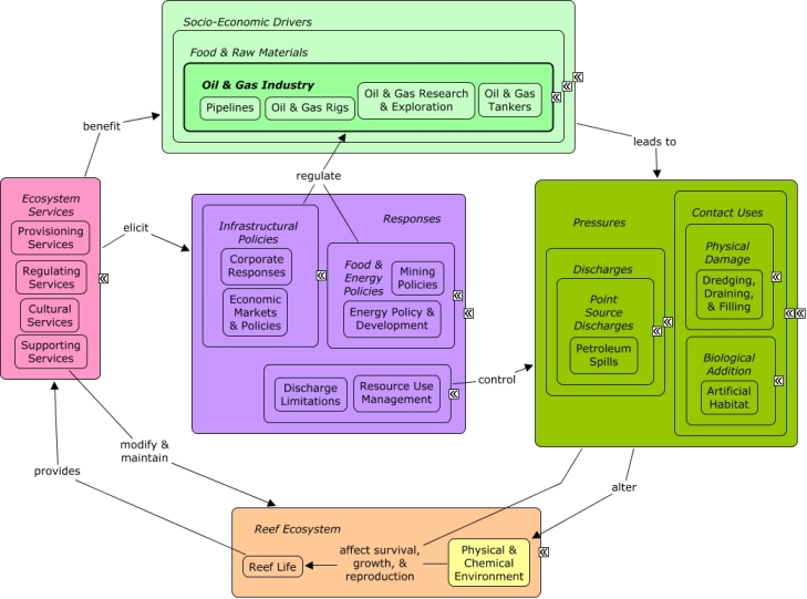
The oil & gas industry depends on a number of physical structures, including pipelines and oil rigs, which may create artificial habitat for fish and invertebrates. Dredging may be needed to construct pipelines, and can damage reef habitat as well as deposit large amounts of sediment in the physical & chemical environment. Activities within the oil & gas industry, including pipelines, tankers, and rigs pose a risk for petroleum spills, which may contaminate the reef ecosystem, affecting growth and survival of reef life. The oil industry benefits indirectly from ecosystem services that improve the well-being of other sectors, such as tourism & recreation, which drive coastal development and the need for energy. Decision-makers can regulate the oil & gas industry through energy management, including limiting the locations and nature of activities or requiring high standard technology. Consumers may pressure the oil & gas industry to respond to environmental concerns by adopting practices that minimize risk.Citations
More than 50 citations. Click here to load.
| Citation | Year | Study Location | Study Type | Database Topics |
|---|
Management Options
| Management Option | Description | Sources | Database Topics |
|---|---|---|---|
| Damage Assessment, Documentation & Response: Coordinated Oil & Hazardous Spill Response | This management option calls for developing unified response protocols to deal with containment and clean-up of oil spills. This is important to protect corals, mangroves, and seagrasses from adverse impacts of hazardous materials. Given the limited number of spills and the importance of responding quickly, interagency coordination of reporting and response is essential for success. | NOAA Marine Sanctuary Program. 2007. Florida Keys National Marine Sanctuary revised management plan. National Ocean Service, Key West, FL. Puerto Rico and USVI Area Planning Committees. 2008. Hazardous Substances Pollution Area Contingency Plan. Puerto Rico and the U.S. Virgin islands. |
Collaboration & Partnering; Decision Support; Discharges; Ecosystem Monitoring & Restoration; Energy Policy & Development; Environmental Monitoring & Restoration; Large Ships; Oil & Gas Industry; Oil & Gas Rigs; Oil & Gas Tankers; Petroleum Spills; Pipelines; Point Source Discharges; Remediation; Resource Use Management; Security & Public Administration Policies; Small Boats; Toxics; Transportation; Water Transportation; Waterborne Discharges |
| Energy Policy & Development: Pipeline Maintenance Requirements | The best way to ensure a high level of safety and reliability in operation of pipelines is to have a maintenance and inspection plan in place that targets damage, degradation or defects before they lead to failures. Economically, expenditures for maintenance and inspection are significantly less than those for emergency service in reaction to unforeseen situations. However, legislative requirements for plans, procedures and documentation ensures compliance with these best management practices. | Environmental Protection Agency. 2008. Pipeline Maintenance Best Practices: Lessons Learned from the Natural Gas STAR Program. Charlotte (North Carolina). United Kingdom Onshore Pipeline Operators� Association. 2006. UKOPA Recommendations for Pipeline Maintenance and Inspection. UKOPA/06/0032, |
Chemical Use Regulations; Discharge Limitations; Discharges; Energy Policy & Development; Infrastructural Policies; Natural Gas & Electric Power; Oil & Gas Industry; Petroleum Spills; Pipelines; Point & Mobile Source Controls; Point Source Discharges; Provisioning Services; Toxics; Utilities; Utility Policies |
| Energy Policy & Development: Cable and Pipeline Construction Assessments | Pre-assessments must be conducted to ensure pipelines and cables buried on the ocean floor will not disrupt or destroy natural or cultural resources. | Reach Networks Hong Kong Ltd. 2007. Project Profile: Asia-America Gateway (AAG) Cable Network, South Lantau. Wanchai, Hong Kong SAR. |
Construction Codes & Projects; Cultural Services; Discharge Limitations; Discharges; Energy Policy & Development; Infrastructural Policies; Natural Gas & Electric Power; Oil & Gas Industry; Permitting & Zoning; Petroleum Spills; Pipelines; Point & Mobile Source Controls; Point Source Discharges; Provisioning Services; Utilities; Utility Policies |
| Resource Use Management: Marine Heritage Resource Protections | This management option involves protecting underwater items/sites that have historical, cultural, archaeological, or paleontological significance. This response advocates permits for action that may degrade the resource. This can be accomplished through creating an MHR field unit, monitoring MHR site degradation, and evaluating excavation and mitigation techniques. Field units can help conduct field research and coordinated, permitted research activities. Experts relating to archaeological research underwater can also be hired with additional funding. Through evaluation of excavation techniques, new technologies can be suggested such as: turbidity screens, sediment removal equipment, and seagrass restoration/relocation protocols to lead to less disturbance. Inventory and decision tools can also be used in the aid of Maritime Heritage Resource protection. | NOAA Marine Sanctuary Program. 2007. Florida Keys National Marine Sanctuary revised management plan. National Ocean Service, Key West, FL. |
Civil Engineering & Construction; Construction Codes & Projects; Cultural Policies; Cultural Protections; Cultural Services; Decision Support; Designated Uses; Dredging Regulations; Dredging, Draining, & Filling; Ecosystem Services; Educational & Research Opportunities; Existence Value & Sense of Place; Mitigation; Physical Damage; Pipelines; Reef Life; Resource Use Management; Seagrasses; Security & Public Administration Policies; Special Use Permitting; Tourism & Recreation Policies; Utility Line Construction & Maintenance; Valuation; Wetlands |
| Restoration: Environmental Remediation | Environmental Remediation is a type of restoration that's focus ranges from Brownfields to Oil Spills to Hazardous Waste Sites. These restoration activities aim to restore the site to a previous condition, or to a condition that is not a threat to human health or other forms of life. Several standards can be used to determine when remediation is necessary and to what extent the environment should be restores. Biocriteria can be used to determine the degree of degradation to biological components of the site. Often it is the presence of a particular pollutant in the soil, water or air, which is above acceptable limits and will not degrade fast enough over a short period of time and therefore must be removed. Physical and chemical water quality criteria can be used to set maximum acceptable limits of water quality parameters. Air quality criteria can be used to set acceptable maximum and minimum air standards for remediation. | Office of Solid Waste and Emergency Response. 2005. Contaminated Sediment Remediation Guidance for Hazardous Waste Sites. EPA-540-R-05-012, US Environmental Protection Agency. Environment Protection Authority. EPA Guidelines for Environmental management of on-site remediation. Environment Protection Authority, Adelaide, Australia. |
Applied Chemicals; Biocriteria; City Planning; Decision Support; Discharge Limitations; Discharges; Ecosystem Monitoring & Restoration; Environmental Monitoring & Restoration; Environmental Monitoring, Mapping, & Scientific Research; Food, Beverage, & Tobacco Products; Health; Health Policies; Landuse Management; Littering; Manufacturing & Trade; Metals, Electronics, & Machinery Products; Military; Mining; Mining Policies; Mitigation; Monetary Valuation; Nutrient & Contaminant Processing; Oil & Gas Industry; Oil & Gas Rigs; Oil & Gas Tankers; Petroleum Spills; Physical & Chemical Water Quality Criteria; Pipelines; Point Source Discharges; Public Administration; Remediation; Security; Solid Waste Disposal; Supporting Services; Toxics; Valuation; Waste Management; Waste Management Policies; Wastewater Discharge; Waterborne Discharges; Wood, Plastics, & Chemical Products |
| Water Quality Management: Protection of Resources from Hazardous Materials & Spills | Wherever possible, take actions to decrease the likelihood of hazardous materials spills near corals. Even when risks are reduced significantly, spills may still occur, necessitating contingency plans (#56). In order for reef managers to stay informed of the latest spills/updates, a spill-reporting system should be established along with a geo-referenced database that keeps track of all spills within a certain distance of reefs. | NOAA Marine Sanctuary Program. 2007. Florida Keys National Marine Sanctuary revised management plan. National Ocean Service, Key West, FL. Puerto Rico and USVI Area Planning Committees. 2008. Hazardous Substances Pollution Area Contingency Plan. Puerto Rico and the U.S. Virgin islands. USCG. 2007. Hazardous Substances Pollution Area Contingency Plan. Florida Keys. |
Discharge Limitations; Discharges; Energy Policy & Development; Food & Energy Policies; Food & Raw Materials; Large Ships; Oil & Gas Industry; Oil & Gas Rigs; Oil & Gas Tankers; Petroleum Spills; Pipelines; Point & Mobile Source Controls; Point Source Discharges; Small Boats; Toxics; Transportation; Waste Management; Waste Management Policies; Water Transportation; Waterborne Discharges |
Laws
| Legal Citation | Purpose of Law | Management Organization | Database Topics |
|---|---|---|---|
| Delineation of the landward extent of wetlands and surface waters, 62-340 Florida Administrative Code Annotated (2000). | The Rule's intent is to provide a unified statewide methodology for the delineation of the extent of wetlands to satisfy the mandate of Section 373.421, F. S. Application to Coral Reefs:Preservation of wetlands will allow them to continue to function as buffers for sediment and contaminant control keeping them from reaching estuarine and marine waters and eventually habitats including coral reefs. Legislative Actions:The Rule is administrative and methodological for delineation purposes. Comments: |
Florida Department of Environmental Protection Jurisdiction: State Coastal Waters; US State Waters; Designated Marine Areas |
Agriculture, Aquaculture, & Forestry Policies; Coastal Development; Dam Construction & Maintenance; Docks & Marinas; Dredging Regulations; Drinking Water Supply; Energy Policy & Development; Finfish & Shellfish Stock; Fish; Invertebrates; Landuse Management; Molluscs; Pipelines; Ports & Harbors; Road Construction & Maintenance; Sediment; Sewage Treatment; Shoreline Armoring; Small Boats; Solid Waste Disposal; Utility Line Construction & Maintenance; Wetlands |
| Environmental Resource Permitting, 62-330 Florida Administrative Code Annotated (2005). | Under the Chapter, DEP exercises its independent authority under Part IV, Chapter 373, F.S., to regulate surface water management systems, including activities in, on or over wetlands or other surface waters. The term "surface water management system" or "system" include stormwater mangement systems, dams, impoundments, reservoirs, appurtenant works, or works, or any combination thereof, and includes dredging and filling. "Dredging" means excavation, by any means, in surface waters or wetlands Application to Coral Reefs:Regulating stormwater management systems, dams, reservoirs and dredging will contribute to controlling contaminates from entering estuarine and marine environments and protect ecosystems including coral reefs., Legislative Actions:Individual permits will contain the conditions for environmental protection. Comments: |
Florida Department of Environmental Protection Jurisdiction: State Coastal Waters; Designated Marine Areas |
City Planning; Construction Codes & Projects; Dam Construction & Maintenance; Docks & Marinas; Dredging Regulations; Dredging, Draining, & Filling; Mangroves; Nutrient & Contaminant Processing; Pipelines; Ports & Harbors; Resource Use Management; Road Construction & Maintenance; Sediment; Surface & Groundwater Flow; Utility Line Construction & Maintenance; Wastewater Discharge |
| Rules and Procedures for Coastal Construction and Excavation, 62B-033 Florida Administrative Code (2008). | (1) The beach and dune system is an integral part of the coastal system and represents one of the most valuable natural resources in Florida, providing protection to adjacent upland properties, recreational areas, and habitat for wildlife. A coastal construction control line (CCCL) is intended to define that portion of the beach and dune system which is subject to severe fluctuations caused by a 100-year storm surge, storm waves, or other forces such as wind, wave, or water level changes. These fluctuations are a necessary part of the natural functioning of the coastal system and are essential to post-storm recovery, long term stability, and the preservation of the beach and dune system. However, imprudent human activities can adversely interfere with these natural processes and alter the integrity and functioning of the beach and dune system. The control line and 50-foot setback call attention to the special hazards and impacts associated with the use of such property, but do not preclude all development or alteration of coastal property seaward of such lines.
(2) In order to demonstrate that construction is eligible for a permit, the applicant shall provide the Department with sufficient information pertaining to the proposed project to show that adverse and other impacts associated with the construction have been minimized and that the construction will not result in a significant adverse impact.
(3) After reviewing all information required pursuant to this rule chapter, the Department shall:
(a) Deny any application for an activity which either individually or cumulatively would result in a significant adverse impact including potential cumulative effects. In assessing the cumulative effects of a proposed activity, the Department shall consider the short-term and long-term impacts and the direct and indirect impacts the activity would cause in combination with existing structures in the area and any other similar activities already permitted or for which a permit application is pending within the same fixed coastal cell. The impact assessment shall include the anticipated effects of the construction on the coastal system and marine turtles. Each application shall be evaluated on its own merits in making a permit decision; therefore, a decision by the Department to grant a permit shall not constitute a commitment to permit additional similar construction within the same fixed coastal cell.
(b) Deny any application for an activity where the project has not met the Department�s siting and design criteria; has not minimized adverse and other impacts, including stormwater runoff; or has not provided mitigation of adverse impacts.
(4) The Department shall issue a permit for construction which an applicant has shown to be clearly justified by demonstrating that all standards, guidelines, and other requirements set forth in the applicable provisions of Part I, Chapter 161, F.S., and this rule chapter are met, including the following:
(a) The construction will not result in removal or destruction of native vegetation which will either destabilize a frontal, primary, or significant dune or cause a significant adverse impact to the beach and dune system due to increased erosion by wind or water;
(b) The construction will not result in removal or disturbance of in situ sandy soils of the beach and dune system to such a degree that a significant adverse impact to the beach and dune system would result from either reducing the existing ability of the system to resist erosion during a storm or lowering existing levels of storm protection to upland properties and structures;
(c) The construction will not direct discharges of water or other fluids in a seaward direction and in a manner that would result in significant adverse impacts. Forthe purposes of this rule section, construction shall be designed so as to minimize erosion induced surface water runoff within the beach and dune system and to prevent additional seaward or off-site discharges associated with a coastal storm event.
(d) The construction will not result in the net excavation of the in situ sandy soils seaward of the control line or 50-foot setback;
(e) The construction will not cause an increase in structure-induced scour of such magnitude during a storm that the structure-induced scour would result in a significant adverse impact;
(f) The construction will minimize the potential for wind and waterborne missiles during a storm;
(g) The activity will not interfere with public access, as defined in Section 161.021, F.S.; and
(h) The construction will not cause a significant adverse impact to marine turtles, or the coastal system.
(5) In order for a manmade frontal dune to be considered as a frontal dune defined under Section 161.053(6)(a)1., F.S., the manmade frontal dune shall be constructed to meet or exceed the protective value afforded by the natural frontal dune system in the immediate area of the subject shoreline. Prior to the issuance of a permit for a single-family dwelling meeting the criteria of Section 161.053(6)(c), F.S., the manmade frontal dune must be maintained for a minimum of 12 months and be demonstrated to be as stable and sustainable as the natural frontal dune system.
(6) Sandy material excavated seaward of the control line or 50-foot setback shall be maintained on site seaward of the control line or 50-foot setback and be placed in the immediate area of construction unless otherwise specifically authorized by the Department.
(7) Swimming pools, wading pools, waterfalls, spas, or similar type water structures are expendable structures and shall be sited so that their failure does not have adverse impact on the beach and dune system, any adjoining major structures, or any coastal protection structure. Pools sited within close proximity to a significant dune shall be elevated either partially or totally above the original grade to minimize excavation and shall not cause a net loss of material from the immediate area of the pool. All pools shall be designed to minimize any permanent excavation seaward of the CCCL.
(8) Major structures shall be located a sufficient distance landward of the beach and frontal dune to permit natural shoreline fluctuations, to preserve and protect beach and dune system stability, and to allow natural recovery to occur following storm-induced erosion. Where a rigid coastal structure exists, proposed major structures shall be located a sufficient distance landward of the rigid coastal structure to allow for future maintenance or repair of the rigid coastal structure. Although fishing piers shall be exempt from this provision, their foundation piles shall be located so as to allow for the maintenance and repair of any rigid coastal structure that is located in close proximity to the pier.(9) If in the immediate area a number of existing major structures have established a reasonably continuous and uniform construction line and if the existing structures have not been unduly affected by erosion, except where not allowed by the requirements of Section 161.053(6), F.S., and this rule chapter, the Department shall issue a permit for the construction of a similar structure up to that line.
(10) In considering applications for single-family dwellings proposed to be located seaward of the 30-year erosion projection pursuant to Section 161.053(6), F.S., the Department shall require structures to meet criteria in Section 161.053(6)(c), F.S., and all other siting and design criteria established in this rule chapter.
(11) In considering project impacts to native salt-tolerant vegetation, the Department shall evaluate the type and extent of native salt-tolerant vegetation, the degree and extent of disturbance by invasive nuisance species and mechanical and other activities, the protective value to adjacent structures and natural plant communities, the protective value to the beach and dune system, and the impacts to marine turtle nesting and hatchlings. The Department shall restrict activities that lower the protective value of natural and intact beach and dune, coastal strand, and maritime hammock plant communities. Activities that result in the removal of protective root systems or reduce the vegetation�s sand trapping and stabilizing properties of salt tolerant vegetation are considered to lower its protective value. Construction shall be located, where practicable, in previously disturbed areas or areas with non-native vegetation in lieu of areas of native plant communities when the placement does not increase adverse impact to the beach and dune system. Planting of invasive nuisance plants, such as those listed in the Florida Exotic Pest Plant Council�s 2005 List of Invasive Species � Categories I and II, will not be authorized if the planting will result in removal or destruction of existing dune-stabilizing native vegetation or if the planting is to occur on or seaward of the dune system. A copy of this list is available on the Internet at www.fleppc.org; or can be obtained by writing to the Department of Environmental Protection, Bureau of Beaches and Coastal Systems, 3900 Commonwealth Boulevard, Mail Station 300, Tallahassee, Florida 32399-3000; or by telephoning (850) 488-7708. Special conditions relative to the nature, timing, and sequence of construction and the remediation of construction impacts shall be placed on permitted activities when necessary to protect native salt-tolerant vegetation and native plant communities. A construction fence, a designated location for construction access or storage of equipment and materials, and a restoration plan shall be required if necessary for protection of existing native salt-tolerant vegetation during construction.
(12) Special conditions relative to the nature, timing, and sequence of construction shall be placed on permitted activities when necessary to protect marine turtles and their nests and nesting habitat. In marine turtle nesting areas, all forms of lighting shall be shielded or otherwise designed so as not to disturb marine turtles. Tinted glass or similar light control measures shall be used for windows and doors which are visible from the nesting areas of the beach. The Department shall suspend any permitted construction when the permittee has not provided the required protection for marine turtles and their nests and nesting habitat. Application to Coral Reefs:Regulation of coastal construction through permit review and modification will protect coastal ecosystems from degradation and loss and in doing so protects other marine ecosystems including coral reefs. Legislative Actions:Chapter 62B-33 Florida Administrative Code, provides the design and siting requirements that must be met to obtain a coastal construction control line permit.Approval or denial of a permit application is based upon a review of the potential impacts to the beach dune system, adjacentproperties, native salt resistant vegetation, and marine turtles. Comments:The Coastal Construction Control Line (CCCL) is an essential element of Florida's coastal management program. It provides protection for Florida's beaches and dunes while assuring reasonable use of private property. Recognizing the value of the state's beaches, the Florida legislature initiated the Coastal Construction Contorl Line Program to protect the coastal system from improperly sited and designed structures which can destabilize or destroy the beach and dune system. Once destabilized, the valuable natural resources are lost, as are its important values for recreation, upland property protection and environmental habitat. Adoption of a coastal construction line establishes an area of jurisdiction in which special siting and design criteria are applied for construction and related activities.These standards may be more stringent than those already applied in the rest of the coastal building zone because of the greater forces expected to occur in the more seaward zone of the beach during a storm event. |
Florida State Department of Environmental Protection Jurisdiction: State Coastal Waters; Designated Marine Areas |
Beach & Land Formation; Building & Home Construction; City Planning; Civil Engineering & Construction; Coastal Development; Construction Codes & Projects; Cruise Ships; Docks & Marinas; Dredging Regulations; Dredging, Draining, & Filling; Hydrologic Management; Landuse Management; Mangroves; Marine Protected Areas; Oil & Gas Tankers; Pipelines; Ports & Harbors; Resource Use Management; Seagrasses; Seawater Flow; Sediment; Shoreline Armoring; Shoreline Protection; Storms & Hurricanes; Tourism & Recreation Policies; Water Depth & Sea Level |
| Sovereign submerged lands management, 18-21 Florida Administrative Code Annotated (2006). | To manage, protect, and enhance sovereignty lands so that the public may continue to enjoy traditional uses, including, but not limited to, navigation, fishing and swimming, public drinking water supply, shellfish harvesting, public recreation, and fish and wildlife propagation and management. Application to Coral Reefs:Permitting activities on submerged lands owned by Florida will improve water quality which will indirectly protect reef systems. Legislative Actions:These rules are to implement the administration and management responsibilities of the board and department regarding sovereign submerged lands. Responsibility for environmental permitting of activities and water quality protection on sovereign lands is vested with the Department of Environmental Protection. These rules are considered cumulative. Comments: |
Florida Department of Environmental Protection Jurisdiction: State Coastal Waters |
Anchoring & Vessel Grounding; Aquaculture; Beach & Land Formation; Coastal Defense; Commercial Fisheries; Construction Codes & Projects; Docks & Marinas; Dredging Regulations; Dredging, Draining, & Filling; Energy Policy & Development; Existence Value & Sense of Place; Oil & Gas Research & Exploration; Pipelines; Point Source Discharges; Ports & Harbors; Recreational Fishing; Recreational Opportunities; Resource Use Management; Seawater Flow; Sediment; Shoreline Protection; Trawling & Fishing Gear Damage |
| Surface water quality standards, 62-302 Florida Administrative Code Annotated (2008). | The Chapter establishes the minimum concentrations of contamination that are allowable to protect the designated uses of a waterbody. Designated uses include public drinking water supplies, propagation of fish and wildlife, agricultural, recreation, industrial, and navigation. Application to Coral Reefs:Protecting surface waters by limiting the concentration of pollutants that can be present will control the concentrations of those pollutants that will reach estuarine and marine environments, thus protecting the associated ecosystems, including coral reefs. Legislative Actions:Penalties are not presented in the Rule. Specific requirements and penalties are addrressed in individual permits. The Rule relies heavily on biocriteria including acute toxicity, chronic toxicity, Shannon-Weaver Diversity Index. Section 400 presents the classes of Florida waters; Class I potable water supplies, Class II shellfish propagation or harvesting, Class III recreation, propagation and maintenance of a healthy, well-balanced population of fish and wildlife, Class IV agricultural water supplies, Class V navigation, utility and industrial use. Comments: |
Florida Department of Environmental Protection Jurisdiction: State Coastal Waters; US State Waters; Designated Marine Areas |
Biocriteria; Biological Monitoring, Mapping, & Scientific Research; Civil Engineering & Construction; Coastal Development; Commercial Fisheries; Complex Habitat & Resources; Dam Construction & Maintenance; Deforestation & Devegetation; Designate Protected Species; Discharge Limitations; Dive, Snorkeling, & Swimming Tourism; Docks & Marinas; Dredging Regulations; Dredging, Draining, & Filling; Drinking Water Supply; Fertilizer & Pesticide Use; Finfish & Shellfish Stock; Fish; Fishing & Harvesting Management; Impervious Surfaces; Invertebrates; Irrigation; Landuse Management; Molluscs; Non-point Source Controls; Non-point Source Runoff; Nutrient & Contaminant Processing; Nutrients; Physical & Chemical Water Quality Criteria; Pipelines; Point & Mobile Source Controls; Point Source Discharges; Ports & Harbors; Recreational Fishing; Sediment; Sewage Treatment; Shoreline Armoring; Small Boats; Tourism & Recreation Policies; Toxics; Waste Management Policies |
| Surface waters of the State, Florida Administrative Code Annotated §§ Chapter 62-301 (1996). | It is the intent of this Chapter to define the landward externt of surface waters of the state. Te findings, declarations, and intentfor this Chapter are the same as those for Chapter 62-302 F. A. C. Application to Coral Reefs:By defining the landward extent of surface waters of the State using dominant plant species, the guidance in the Chapter will include wetlands and transitional zones on many occasions. Through the protection of these areas, filtration of sediment and nutrients will be maintained and two of the harmful parameters for coral reefs will be reduced. Legislative Actions:The Chapter is a guidance document and does not contain penalties. The Chapter provides a list of plant species for use with the guidance as well as the methods of calculating the areas of state waters. Comments: |
Florida Department of Environmental Protection Jurisdiction: State Coastal Waters; US State Waters; Designated Marine Areas |
Arthropods; Ballast Discharge; Beaches & Nature Parks; Biotechnology Research & Development; Building & Home Construction; Coastal Development; Docks & Marinas; Dredging Regulations; Dredging, Draining, & Filling; Finfish & Shellfish Stock; Fish; Fishing & Harvesting Management; Forestry; Invertebrates; Landscape Conservation & Restoration; Landuse Management; Mangroves; Marine Birds; Marine Vertebrates; Molluscs; Non-point Source Runoff; Nutrient & Contaminant Processing; Petroleum Spills; Pipelines; Ports & Harbors; Recreational Fishing; Resource Use Management; Sea Turtles; Seagrasses; Sediment; Shoreline Armoring; Small Boats; Surface & Groundwater Flow; Utility Line Construction & Maintenance; Wastewater Discharge; Wetlands; Whales & Dolphins |
| Uniform Mitigation Assessment Method, Florida Administrative Code Annotated §§ Chapter 62-345 (2005). | Establishes a methodology that provides a standard procedure for assessing the functions provided by wetlands and other surface waters, the amount that those functions are reduced by a proposed impact, and the amount of mitigation necessary to offset that loss. Application to Coral Reefs:Protecting wetlands provides wetland areas that can act as buffers against nutrients, pollutants and contaminants from reaching habitats including coral reefs. Legislative Actions:The Chapter is administrative and provides methods to assess wetland value and appropriate mitigation to offset impact. Comments: |
Florida Department of Environmental Protection Jurisdiction: State Coastal Waters |
Agriculture, Aquaculture, & Forestry Policies; Building & Home Construction; Civil Engineering & Construction; Coastal Development; Coastal Engineering; Complex Habitat & Resources; Construction Codes & Projects; Dam Construction & Maintenance; Docks & Marinas; Dredging Regulations; Dredging, Draining, & Filling; Finfish & Shellfish Stock; Forestry; Land-Based Civil Engineering; Landuse Management; Mangroves; Nutrient & Contaminant Processing; Oil & Gas Research & Exploration; Pipelines; Ports & Harbors; Recreational Opportunities; Resource Use Management; Road Construction & Maintenance; Seagrasses; Sediment; Shoreline Armoring; Surface & Groundwater Flow; Utility Line Construction & Maintenance; Wetlands |
| Wetland applications, 62-611 Florida Administrative Code Annotated (1996). | To provide qualitative and quantitative design criteria discharge limits, permitting requirements, and monitoring requirements for wetlands, man-made and natural, receiving domestic wastewater. Application to Coral Reefs:Because wetlands act as buffers and remove nutrients from contaminated water, in many case the nutrients will not reach the estuarine and marine environments and potentially have an adverse effect on coral reefs. Legislative Actions:The Rule is administrative in nature and specific pollutant limits and monitoring requirements are specified in individual permits Comments: |
Florida Department of Environmental Protection Jurisdiction: State Coastal Waters |
Agriculture, Aquaculture, & Forestry Policies; City Planning; Construction Codes & Projects; Environmental Education & Outreach; Hydrologic Management; Landuse Management; Mangroves; Nutrients; Pipelines; Point Source Discharges; Resource Use Management; Seagrasses; Sewage Treatment; Waste Management Policies; Wastewater Discharge |