ReefLink Database
Permitting & Zoning
Permitting is documentation required for new construction and remodeling/renovation, in compliance with national, regional, and local zoning and building codes. Zoning can be used to establish the distribution of land uses, from high intensity development to public parks.
CMap
CMap Description
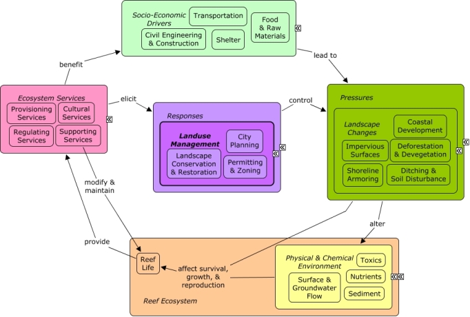
A change in the provision of ecosystem services, or a desire to improve provision of ecosystem services, may elicit responses to reduce or manage changes to the landscape that can create pressures on the reef. Coastal development contributes to landscape changes, including impervious surfaces, devegetation, shoreline armoring, dredging, or filling for construction of roads and buildings, which can alter rates of pollutant runoff, directly impact coastal vegetation, and alter patterns of water flow. Permitting & zoning can be used to control the distribution and intensity of development, or encourage the establishment of green spaces. Many of the same socio-economic sectors that drive coastal development and landscape changes, also benefit from reef ecosystem services, including aesthetic value, seafood, and shoreline protection.Citations
| Citation | Year | Study Location | Study Type | Database Topics |
|---|---|---|---|---|
| Scholte, P; Al-Okaishi, A; Suleyman, AS. 2011. When conservation precedes development: a case study of the opening up of the Socotra archipelago, Yemen. ORYX 45:401-410. | 2011 | Indian Ocean; India | Decision Support Frameworks & Tools | Finfish Harvest; Landscape Conservation & Restoration; Landuse Management; Permitting & Zoning; Resource Use Management; Road Construction & Maintenance; Special Use Permitting |
| Hoitink, A. J. F. 2003. Physics of coral reef systems in a shallow tidal embayment. Nederlandse Geografische Studies 313:11-141. | 2003 | Global | Calcium Carbonate Deposition; Discharges; Landuse Management; Non-point Source Runoff; Nutrients; Permitting & Zoning; Salinity; Sediment; Substrate; Surface & Groundwater Flow | |
| Chevalier, F., J.-P. Garcia, D. Quesne, M. Guiraud, and J.-C. Menot. 2001. Correlations and genetic stratigraphy through Oxfordian reefal formations in the upper Yonne valley (southern Paris basin, France) [Correlations et interpretations genetiques dans les formations recifales oxfordiennes de la haute vallee de l'Yonne. Bulletin de la Societe Geologique de France 172:69-84. | 2001 | France | Field Study & Monitoring; Model | Landuse Management; Permitting & Zoning; Sediment; Storms & Hurricanes |
| Dustan, P. 2000. Florida Keys. Seas at the millennium - an environmental evaluation - Volume 1 405-414. | 2000 | Global; South & Central America; Florida; Caribbean | Field Study & Monitoring | Agriculture; Anchoring & Vessel Grounding; Environmental Monitoring, Mapping, & Scientific Research; Landuse Management; Mangroves; Nutrients; Permitting & Zoning; Pipelines; Sea Urchins; Seagrasses; Seawater Flow; Sediment; Tourism & Recreation |
| Lee Long, W. J., R. G. Coles, and L. J. McKenzie. 1999. Issues for seagrass conservation management in Queensland. Pacific Conservation Biology 5:321-328. | 1999 | Australia | Field Study & Monitoring | Agriculture; Chemical Use Regulations; Commercial Fisheries; Fertilizer & Pesticide Use; Finfish Harvest; Fishing Sector; Landuse Management; Lobster, Crab, & Shrimp; Marine Protected Areas; Nutrients; Permitting & Zoning; Petroleum Spills; Sea Turtles; Seagrasses; Sediment; Surface & Groundwater Flow |
| Gibson, J., M. McField, and S. Wells. 1998. Coral reef management in Belize: An approach through integrated coastal zone management. Ocean and Coastal Management 39:229-244. | 1998 | South & Central America; Belize | Field Study & Monitoring | Banks, Credit, & Securities; Coastal Development; Finfish Harvest; Landuse Management; Non-point Source Runoff; Permitting & Zoning; Sediment; Storms & Hurricanes; Tourism & Recreation; Tourism & Recreation Policies |
| Cocks, K. D. and B. H. Walker. 1994. Contribution of \sustainability' criteria to social perceptions of land use options". Land Degradation & Rehabilitation 5:143-151. | 1994 | Australia | Environmental Monitoring, Mapping, & Scientific Research; Landscape Changes; Landuse Management; Marine Protected Areas; Permitting & Zoning | |
| Gable, F. J., D. G. Aubrey, and J. H. Gentile. 1991. Global environmental change issues in the Western Indian Ocean region. Geoforum 22:401-419. | 1991 | Global; Indian Ocean; India | Model | Climate; CO2; Economic Markets & Policies; Landuse Management; Mangroves; Mitigation; Permitting & Zoning; Storms & Hurricanes; Tourism & Recreation; Tourism & Recreation Policies; Water Depth & Sea Level; Wetlands |
| Hatcher, A. I., G. D. Wright, and B. G. Hatcher. 1990. Resolving the conflict between conservation values and extractive use of the Abrolhos coral reefs. Pages 55-70 in Australian ecosystems. Proc. symposium, Geraldton, W.A., 1988. | 1990 | Australia; Indian Ocean; India | GIS & Maps | Finfish Harvest; Fishing Sector; Landuse Management; Lobster, Crab, & Shrimp; Permitting & Zoning |
| Ramsay, P. J. and T. R. Mason. 1990. Development of a type zoning model for Zululand coral reefs, Sodwana Bay, South Africa. Journal of Coastal Research 6:829-852. | 1990 | South Africa | Model | Landuse Management; Octocoral; Permitting & Zoning |
| [No author name available]. 1985. Protection of the Great Barrier Reef. Report of the House of Representatives Standing Committee on Environment and Conservation. in [No source information available]. | 1985 | Australia | Field Study & Monitoring | Environmental Monitoring, Mapping, & Scientific Research; Housing; Landuse Management; Permitting & Zoning; Seastars; Tourism & Recreation |
| Cocks, K. D. 1984. A systematic method of public use zoning of the Great Barrier Reef Marine Park, Australia. Coastal Zone Management Journal 12:359-383. | 1984 | Australia | Landuse Management; Marine Protected Areas; Permitting & Zoning | |
| Seymour John, L. 1975. Preliminary Legal Considerations In Developing Artificial Reefs. Coastal Zone Management Journal 2:149-169. | 1975 | Decision Support Frameworks & Tools | Artificial Habitat; Construction Codes & Projects; Fish; Fishing Sector; Permitting & Zoning | |
| Dugan, G. L. and R. H. F. Young. 1973. Effects of coastal water disposal in Hawaii. Pages 691-701 in J.ENVIRONM.ENGN DIV.PROC.ASCE. | 1973 | US Pacific & Hawaii | Agriculture; Landuse Management; Non-point Source Runoff; Nutrients; Permitting & Zoning; Physical & Chemical Water Quality Criteria; Point & Mobile Source Controls; Point Source Discharges; Sediment |
Management Options
| Management Option | Description | Sources | Database Topics |
|---|---|---|---|
| Damage Assessment, Documentation & Response: Respond to Natural Resource Injuries from Coastal Construction & Development | This involves assessing coral, seagrass, and hard bottom substrate that is impacted during coastal construction repair or alternation. If unacceptable damages are occurring this information will be useful in future permit decision making. If infringements have occurred, this information may be useful for compensatory mitigation and liability for restoration of those natural resources injured. | NOAA Marine Sanctuary Program. 2007. Florida Keys National Marine Sanctuary revised management plan. National Ocean Service, Key West, FL. |
Biological Monitoring & Restoration; Civil Engineering & Construction; Coastal Development; Coastal Engineering; Construction Codes & Projects; Docks & Marinas; Dredging Regulations; Dredging, Draining, & Filling; Ecosystem Monitoring & Restoration; Environmental Monitoring & Restoration; Impervious Surfaces; Infrastructural Policies; Infrastructure; Land-Based Civil Engineering; Landscape Changes; Mangroves; Mitigation; Permitting & Zoning; Physical Damage; Physical Variables; Ports & Harbors; Reef Habitat; Remediation; Resource Use Management; Seagrasses; Shoreline Armoring; Special Use Permitting; Utilities; Utility Line Construction & Maintenance; Wetland & Reef Restoration; Wetlands |
| Develop & Distribute Educational Materials: Develop Roadside Signs | Roadside signs and billboards in local reef watershed areas should be created to inform travelers that they are entering/exiting the reef watershed. Partnerships should be explored to create multi-logo signs. | NOAA Marine Sanctuary Program. 2007. Florida Keys National Marine Sanctuary revised management plan. National Ocean Service, Key West, FL. |
Collaboration & Partnering; Environmental Education & Outreach; Infrastructural Policies; Landscape Conservation & Restoration; Permitting & Zoning; Resource Use Management; Security & Public Administration Policies; Tourism & Recreation Policies; Transportation Policies |
| Energy Policy & Development: Oil and Gas Rig Construction Regulations | The Minerals Management Service (MMS) has several requirements for leasing and permits for construction of new drilling rigs and platforms. Placement is very important so as to not interfere with other uses or the environment. These permits also cover exploratory structures for research and test sites. | Minerals Management Service. 2006. Leasing Oil and Natural Gas Resources. U.S. Department of the Interior. |
Civil Engineering & Construction; Construction Codes & Projects; Discharge Limitations; Discharges; Economic Markets & Policies; Energy Policy & Development; Infrastructural Policies; Infrastructure; Manufacturing & Trade Policies; Natural Gas & Electric Power; Oil & Gas Industry; Oil & Gas Research & Exploration; Oil & Gas Rigs; Permitting & Zoning; Petroleum Spills; Point & Mobile Source Controls; Point Source Discharges; Provisioning Services; Toxics; Utilities; Utility Policies |
| Energy Policy & Development: Cable and Pipeline Construction Assessments | Pre-assessments must be conducted to ensure pipelines and cables buried on the ocean floor will not disrupt or destroy natural or cultural resources. | Reach Networks Hong Kong Ltd. 2007. Project Profile: Asia-America Gateway (AAG) Cable Network, South Lantau. Wanchai, Hong Kong SAR. |
Construction Codes & Projects; Cultural Services; Discharge Limitations; Discharges; Energy Policy & Development; Infrastructural Policies; Natural Gas & Electric Power; Oil & Gas Industry; Permitting & Zoning; Petroleum Spills; Pipelines; Point & Mobile Source Controls; Point Source Discharges; Provisioning Services; Utilities; Utility Policies |
| Energy Policy & Development: Develop Offshore Wind and Hydrokinetic Alternative Energies | Policies encouraging or authorizing construction of offshore facilities are evolving, and there are many sides to the issue of how to best manage them. Alternative energies are desirable and would reduce the dependence on fossil fuel resources. However, hydrokinetic technologies are just becoming viable, meaning long term impacts are still unknown. Facilitative policies reduce barriers for alternative energy development or increase barriers or costs for incumbent technologies. These include research and innovation policies, technology improvement subsidies, market based policies that internalize externalities, and regulatory changes that simplify the permitting process. | Energy Efficiency & Renewable Energy. 2009. Report to Congress on the Potential Environmental Effects of Marine and Hydrokinetic Energy Technologies. Department of Energy. Portman, M.E. 2010. Marine Renewable Energy Policy: Some US and International Perspectices Compared. Oceanography 23:98-105. |
Artificial Habitat; Biological Addition; Construction Codes & Projects; Economic Markets & Policies; Energy Policy & Development; Funding & Incentives; Infrastructural Policies; Natural Gas & Electric Power; Oil & Gas Industry; Permitting & Zoning; Petroleum Spills; Physical Variables; Point Source Discharges; Provisioning Services; Seawater Flow; Utilities; Utility Line Construction & Maintenance; Utility Policies |
| Energy Policy & Development: Oil and Gas Rig End of Life | As oil production at a given offshore site decreases it becomes necessary to decommission the rigs that were drilling them. It is very expensive to dismantle and transport the rigs back to shore. One such well know case was Shell's Brent Spar 1995. Regulations on the end of life for oil rigs differ by country and even state within the US. The Minerals Management Service has a Rigs-to-Reefs program which supports and encourages the reuse of oil and gas structures for offshore artificial reef developments. If these structures are to be sunk as artificial reefs the normal permit requirements for artificial reefs still apply to ensure the structure will not interfere with navigation channels or degrade the environment. | Dauterive, L. 1999. Rigs-to reefs policy, progress, and perspective. Pages 313-318 in SPE/EPA Exploration & Production Environmental Conference. |
Anchoring & Vessel Grounding; Artificial Habitat; Biological Addition; Chemical Variables; Civil Engineering & Construction; Construction Codes & Projects; Cultural Services; Discharge Limitations; Discharges; Infrastructural Policies; Infrastructure; Littering; Manufacturing & Trade; Marine Debris; Natural Gas & Electric Power; Oil & Gas Industry; Permitting & Zoning; Petroleum Spills; Point & Mobile Source Controls; Point Source Discharges; Provisioning Services; Solid Waste Disposal; Toxics; Utilities; Utility Policies; Waste Management; Water Depth & Sea Level; Water Resources |
| Enforcement: Enforce Statues, Regulation and Permit Requirements | This option ensures compliance with statues, regulations, and permit requirements. This is accomplished through intensive on-site patrols by authorized law enforcement officers. Agencies at the state level as well as NOAA can assist with enforcement. For success, it is important that law enforcement be trained in the compliance requirements of other agencies (e.g. Marine Heritage Resource (MHR) permitting compliance). A standardized training program to help better ensure cross- deputization of enforcement agencies would be necessary. | NOAA Marine Sanctuary Program. 2007. Florida Keys National Marine Sanctuary revised management plan. National Ocean Service, Key West, FL. |
Boating Regulations; Collaboration & Partnering; Cultural Protections; Dredging Regulations; Fisheries & Hunting Policies; Fishing & Harvesting Management; Permitting & Zoning; Resource Use Management; Security & Public Administration Policies; Special Use Permitting |
| Marine Zoning: Ecological Reserves (ERs) | Ecological Reserves set aside areas with minimal human interference. These reserves aim to enhance and protect biodiversity through encompassing large, contiguous habitats. The goal of ecological reserves is to encourage spawning, nurseries, and residence areas that contribute to genetic protection of fish and marine life. Ecological Reserves can be achieved through a variety of methods such as: placing/maintaining buoys along zone boundaries; adjusting boundaries if necessary; evaluating allowable activities within zone boundaries; identifying potential areas that need additional zoning; reviewing the effectiveness of the zoning; and revising NOAA and GIS charts. | NOAA Marine Sanctuary Program. 2007. Florida Keys National Marine Sanctuary revised management plan. National Ocean Service, Key West, FL. |
Biochemical & Genetic Resources; Biological Addition; Biological Harvest; Biological Monitoring & Restoration; Boating Activities; Boating Regulations; Coastal Defense; Commercial Fishing Boats; Complex Habitat & Resources; Cruise Ships; Decision Support; Designated Uses; Dredging Regulations; Dredging, Draining, & Filling; Ecosystem Monitoring & Restoration; Environmental Monitoring & Restoration; Finfish Harvest; Fisheries & Hunting Policies; Fishing & Harvesting Management; Fishing Sector; Invertebrate Harvest; Large Ships; Live Collection; Marine Protected Areas; Oil & Gas Tankers; Permitting & Zoning; Physical Damage; Provisioning Services; Resource Use Management; Security Policies; Small Boats; Tourism & Recreation; Trampling; Water Transportation |
| Marine Zoning: Existing Management Areas | The Florida Keys National Marine Sanctuary (FKNMS) uses this zoning category to identify areas that are managed by other agencies where restrictions already exist. These zones delineate the existing jurisdictional authority of other agencies (i.e., State parks, aquatic preserves, sanctuaries, and other restricted areas). Management of these areas within the Sanctuary may require additional regulations or restrictions to adequately protect resources. Any additional management measures will be developed and implemented in coordination with the agency having jurisdictional authority. Their function is not to establish another layer of bureaucracy, but to recognize established management areas and, at a minimum, to complement the existing management programs, ensuring cooperation and coordination with other agencies. Existing Management Areas will be maintained through revising GIS and NOAA charts. | NOAA Marine Sanctuary Program. 2007. Florida Keys National Marine Sanctuary revised management plan. National Ocean Service, Key West, FL. |
Accidental & Illegal Harvest; Beaches & Nature Parks; Biological Harvest; Biological Monitoring & Restoration; Boating Activities; Coastal Defense; Contact Uses; Decision Support; Designate Protected Species; Designated Uses; Ecosystem Monitoring & Restoration; Entertainment & Accommodation Services; Environmental Education & Outreach; Environmental Monitoring & Restoration; Fisheries & Hunting Policies; Fishing & Harvesting Management; Marine Protected Areas; Permitting & Zoning; Recreational Fishing; Resource Use Management; Tourism & Recreation; Water Transportation |
| Marine Zoning: Integrate Resource Information in Permits, Authorizations, or Certifications | Permitting usually includes assessing the natural and cultural resources of an area. Using this previosly gathered data would aid in creating an inventory for marine resources. If previosuly established, the management option (#165), will allow this data to be combined with data from other inventory management options such as (#95), and future integration into larger databases, such as that in the management option (#85). | NOAA Marine Sanctuary Program. 2007. Florida Keys National Marine Sanctuary revised management plan. National Ocean Service, Key West, FL. |
Boating Regulations; Collaboration & Partnering; Construction Codes & Projects; Decision Support; Designated Uses; Permitting & Zoning; Resource Use Management; Special Use Permitting |
| Marine Zoning: Wildlife Management Areas (WMAs) | Wildlife Management Areas include bird nesting, resting, or feeding areas, turtle nesting beaches, and other sensitive habitats including shallow flats that are important feeding areas for fish. These areas seek to provide protection for endangered/threatened species or their habitats while at the same time providing opportunity for public use. Wildlife Management Areas are achieved through placing and maintaining buoys along zone boundaries; implementing management responsibilities; adjusting existing zone boundaries if needed; evaluating allowable activities within the boundaries and make changes if needed; identifying potential areas that need additional zoning; monitoring the effectiveness of current zones; and revising GIS and NOAA charts. | NOAA Marine Sanctuary Program. 2007. Florida Keys National Marine Sanctuary revised management plan. National Ocean Service, Key West, FL. |
Accidental & Illegal Harvest; Beaches & Nature Parks; Biological Harvest; Biological Monitoring & Restoration; Boating Activities; Coastal Defense; Contact Uses; Cultural Services; Decision Support; Designate Protected Species; Designated Uses; Ecosystem Monitoring & Restoration; Entertainment & Accommodation Services; Environmental Monitoring & Restoration; Fisheries & Hunting Policies; Fishing & Harvesting Management; Fishing Sector; Landscape Conservation & Restoration; Marine Birds; Marine Protected Areas; Permitting & Zoning; Physical Damage; Recreational Fishing; Recreational Opportunities; Resource Use Management; Sea Turtles; Tourism & Recreation; Trampling; Water Transportation; Wetlands |
| Marine Zoning: Permitting Application & Award | This management approach is important because permits assure protection and conservation of coral resources from harmful activities and practices. Within sanctuary waters, special use permits (#157) can be used to allow scientists and others to conduct necessary work while following permitting regulations to reduce the impact of that work. General permits are often required for altering land-use, construction projects and certain discharges. To be eligible for a permit, the operator may be required to conduct impact assessments, institute best management practices and conduct monitoring of the project. Though permits are a necessary precaution, the process can be streamlined through ensuring clear submittal requirements, and reducing redundancy. Redundancy often occurs when multiple agencies must approve a permit, a single point of contact and standard, inter-agency protocols can reduce unnecessary redundancy. | NOAA Marine Sanctuary Program. 2007. Florida Keys National Marine Sanctuary revised management plan. National Ocean Service, Key West, FL. |
Biological Addition; Biological Harvest; Building & Home Construction; Coastal Development; Collaboration & Partnering; Cultural Policies; Discharges; Dredging, Draining, & Filling; Impervious Surfaces; Land-Based Civil Engineering; Landscape Changes; Landuse Management; Permitting & Zoning; Physical Damage; Point Source Discharges; Public Administration; Resource Use Management; Scientific Research; Security & Public Administration Policies; Special Use Permitting |
| Marine Zoning: Sanctuary Preservation Areas (SPAs) | This is a type of Marine Zoning used by the Florida Keys National Marine Sanctuary (FKNMS). SPAs focus on the protection of shallow, heavily used reefs where conflicts occur between user groups, and where concentrated visitor activity leads to resource degradation. They are designed to enhance the reproductive capabilities of renewable resources, protect areas critical for sustaining and protecting important marine species, and reduce user conflicts in high-use areas. This is accomplished through a prohibition of consumptive activities within these areas. They have been chosen based on the status of important habitat, the ability of a particular area to sustain and protect the habitat, the level of visitor use, and the degree of conflict between consumptive and non-consumptive users. The actual size and location of these zones have been determined by examination of user patterns, aerial photography, and ground-truthing of specific habitats. | NOAA Marine Sanctuary Program. 2007. Florida Keys National Marine Sanctuary revised management plan. National Ocean Service, Key West, FL. |
Accidental & Illegal Harvest; Anchoring & Vessel Grounding; Aquaculture; Aquarium & Pet Trade; Aquarium Stock; Artisanal Fishing; Beaches & Nature Parks; Biological Addition; Biological Harvest; Biological Monitoring & Restoration; Boat Movement; Boating Activities; Boating Regulations; Coastal Defense; Coastal Development; Coastal Engineering; Commercial Fisheries; Commercial Fishing Boats; Complex Habitat & Resources; Cruise Ships; Cultural Services; Decision Support; Designated Uses; Dive, Snorkeling, & Swimming Tourism; Dredging Regulations; Dredging, Draining, & Filling; Ecosystem Monitoring & Restoration; Educational & Research Opportunities; Entertainment & Accommodation Services; Environmental Monitoring & Restoration; Finfish & Shellfish Stock; Finfish Harvest; Fisheries & Hunting Policies; Fishing & Harvesting Management; Fishing Sector; Invertebrate Harvest; Landscape Changes; Large Ships; Live Collection; Marine Protected Areas; Oil & Gas Tankers; Ornamental Jewelry & Art; Permitting & Zoning; Physical Damage; Public Administration; Recreational Fishing; Recreational Opportunities; Resource Use Management; Security; Small Boats; Souvenir & Decorative Trade; Supporting Services; Tourism & Recreation; Tourism & Recreation Policies; Trampling; Travel Services & Tour Operators; Trawling & Fishing Gear Damage; Water Resources; Water Transportation |
| Marine Zoning: Special Use Areas | Special use areas are set aside for specific scientific or educational purposes. This is in order to encourage the recovery or restoration of injured or degraded resources. Also, the areas may be designated to facilitate access to, or use of, resources, and prevent other user conflicts. Special-use areas are achieved through a variety of methods such as: placing/maintaining buoys along zone boundaries; adjusting boundaries if necessary; evaluating allowable activities within zone boundaries; identifying potential areas that need additional zoning; reviewing the effectiveness of the zoning; and revising NOAA and GIS charts; and determining/establishing appropriate zones for high-impact or user-conflict activities. | NOAA Marine Sanctuary Program. 2007. Florida Keys National Marine Sanctuary revised management plan. National Ocean Service, Key West, FL. |
Biological Addition; Biological Harvest; Biological Monitoring & Restoration; Biological Monitoring, Mapping, & Scientific Research; Biomedical Research Policies; Complex Habitat & Resources; Contact Uses; Cultural Services; Decision Support; Designated Uses; Ecosystem Monitoring & Restoration; Education & Information; Educational & Research Opportunities; Environmental Education & Outreach; Environmental Monitoring & Restoration; Environmental Monitoring, Mapping, & Scientific Research; Health Policies; Marine Protected Areas; Permitting & Zoning; Physical Damage; Provisioning Services; Resource Use Management; Scientific Research; Social Organizations; Special Use Permitting; Supporting Services; Wetland & Reef Restoration |
| Marine Zoning: Utilize Marine Protected Areas for Research and Monitoring | Research and monitoring of marine protected areas determine the degree to which the zones meet goals and objectives for protecting natural resources, as well as human-use patterns, attitudes and compliance. Once data is gathered from within the protected zone it can than be compared to comprable data from outside the protected zone, as a control. It is necessary to compile and review data on use patterns to determine where additional Special-Use Areas would be appropriate. Research in the protected area should be non-invasive. It is important to make the protected area available for external research as well. | NOAA Marine Sanctuary Program. 2007. Florida Keys National Marine Sanctuary revised management plan. National Ocean Service, Key West, FL. |
Biological Harvest; Biological Monitoring & Restoration; Biological Monitoring, Mapping, & Scientific Research; Collaboration & Partnering; Contact Uses; Decision Support; Designated Uses; Discharges; Ecosystem Monitoring & Restoration; Educational & Research Opportunities; Environmental Monitoring & Restoration; Fish; Invasive Species; Invertebrates; Landscape Changes; Marine Protected Areas; Marine Vertebrates; Permitting & Zoning; Physical Damage; Resource Use Management; Special Use Permitting; Wetlands |
| Monitor & Research: Survey and Collect Anecdotal Information | Anecdotal information is to be solicited from experts and amateur public participation through surveys and workshops. Persons of interest include fishermen, recreational divers, recreational dive facilities, salvors and other locals with knowledge of marine resources in the area. Information they provide can help identify marine cultural and natural resources and help update resource inventory. | NOAA Marine Sanctuary Program. 2007. Florida Keys National Marine Sanctuary revised management plan. National Ocean Service, Key West, FL. |
Artisanal Fishing; Biological Harvest; Boating Regulations; Coastal Engineering; Collaboration & Partnering; Commercial Fisheries; Contact Uses; Cultural Policies; Cultural Protections; Cultural Services; Decision Support; Designated Uses; Dive, Snorkeling, & Swimming Tourism; Educational & Research Opportunities; Existence Value & Sense of Place; Finfish & Shellfish Stock; Fisheries & Hunting Policies; Fishing & Harvesting Management; Fishing Sector; Marine Products; Permitting & Zoning; Physical Damage; Provisioning Services; Recreational Fishing; Recreational Opportunities; Resource Use Management; Responses; Security & Public Administration Policies; Tourism & Recreation; Tourism & Recreation Policies; Valuation; Water Transportation |
| Monitor & Research: Utilize Managed Areas for Socioeconomic Research | Data are needed to test hypotheses about the socioeconomic impact of marine zoning and user-group perceptions about changes in natural resources within the sanctuary area. User-group perception of changes in natural resources can be compared with quantitative ecological data to identify misconceptions and knowledge gaps. Providing funding opportunities for external scientists to conduct research in the managed area is another option. | NOAA Marine Sanctuary Program. 2007. Florida Keys National Marine Sanctuary revised management plan. National Ocean Service, Key West, FL. |
Contact Uses; Cultural Services; Culture; Decision Support; Designated Uses; Economic Markets & Policies; Ecosystem Monitoring & Restoration; Educational & Research Opportunities; Environmental Education & Outreach; Food & Raw Materials; Infrastructural Policies; Landuse Management; Marine Protected Areas; Monetary Valuation; Non-Monetary Valuation; Permitting & Zoning; Provisioning Services; Reef Habitat; Reef Inhabitants; Regulating Services; Resource Use Management; Special Use Permitting; Supporting Services; Valuation |
| Regulatory Review and Development: Evaluate Channel & Reef Navigation Markers | This option would evaluate the need for proper marking to ensure better navigation. There are many types of markers, including buoys, charts, beacons, and GPS mapping. Such markers can also be used to advocate prohibition on vessel speeds greater than idle speed in areas designated as idle-speed only/no-wake and around shallow reef locations. | NOAA Marine Sanctuary Program. 2007. Florida Keys National Marine Sanctuary revised management plan. National Ocean Service, Key West, FL. |
Anchoring & Vessel Grounding; Beach & Land Formation; Boat Movement; Boating Activities; Boating Regulations; Coastal Development; Contact Uses; Cultural Services; Culture; Decision Support; Designated Uses; Dive, Snorkeling, & Swimming Tourism; Dredging Regulations; Permitting & Zoning; Physical Damage; Provisioning Services; Public Administration; Recreational Fishing; Recreational Opportunities; Security & Public Administration Policies; Small Boats; Tourism & Recreation; Trampling; Transportation Policies; Water Depth & Sea Level; Water Resources; Water Transportation |
| Regulatory Review and Development: Evaluate Artificial Reef Regulations | Discharge/depositing of materials and constructions on the seabed are both prohibited without permits, regulating the construction of new artificial reefs. Likewise, existing artificial reefs are protected through permit requirements for any alternation of the seabed. There are still further considerations for protecting artificial reefs. Artificial reef materials and construction choices are very important and may change based on the specific location and desired impacts. An artificial reef to attract recreational fishing differs from one for recreational divers or shoreline storm protection. Many artificial reefs were formally large ships, oil rigs or other types of waste that have been decommissioned and would be too large and expensive to dismantle on land. In these cases it is important to put restrictions on the sinking process to ensure there won�t be any type of chemical leakage and that the structure is stable on the seabed. (#189) (#190) | National Oceanic and Atmospheric Administration. 2007. National Artificial Reef Plan: Guidelines for Siting, Construction, Development, and Assessment of Artificial Reefs. US Department of Commerce. NOAA Marine Sanctuary Program. 2007. Florida Keys National Marine Sanctuary revised management plan. National Ocean Service, Key West, FL. |
Artificial Habitat; Coastal Defense; Contact Uses; Discharge Limitations; Discharges; Dive, Snorkeling, & Swimming Tourism; Dredging Regulations; Environmental Monitoring & Restoration; Large Ships; Oil & Gas Industry; Permitting & Zoning; Physical Damage; Recreational Fishing; Solid Waste Disposal; Special Use Permitting; Tourism & Recreation; Waste Management; Waterborne Discharges |
| Resource Use Management: Seasonal Fisheries and Harvesting | Finfish and shellfish stocks may be more or less susceptible to fishing pressures during certain times of the year. This may be due to seasonality of recruitment and/or changes in food/predation pressures. If fishing restrictions may be more successful if this seasonality is taken into consideration and fishing pressure adjusted accordingly. | Accidental & Illegal Harvest; Apex Fish Predators; Artisanal Fishing; Biochemical & Genetic Resources; Biological Harvest; Bivalves; Commercial Fisheries; Corallivorous Fish; Decision Support; Echinoderms; Finfish & Shellfish Stock; Finfish Harvest; Fish; Fisheries & Hunting Policies; Fishing & Harvesting Management; Fishing Sector; Food & Energy Policies; Invertebrate Harvest; Invertivorous Fish; Large Herbivorous Fish; Live Collection; Lobster, Crab, & Shrimp; Marine Products; Molluscs; Octopus & Squid; Permitting & Zoning; Piscivorous Fish; Planktivorous Fish; Provisioning Services; Recreational Fishing; Small Herbivorous Fish; Snails & Conch; Sponges; Tourism & Recreation Policies | |
| Resource Use Management: Fisheries Management Enforcement | Marine protected areas and other types of coastal zone management areas have fisheries management policies that must be enforced in addition to the broader Statues, Regulation and Permit Requirements (#91). Illegal, unregulated and unreported (IUU) fishing is a major problem worldwide. Management area policies must be enforced to have an impact on the fisheries stock. | Accidental & Illegal Harvest; Artisanal Fishing; Biological Harvest; Boating Activities; Boating Regulations; Commercial Fisheries; Decision Support; Designated Uses; Ecosystem Monitoring & Restoration; Finfish Harvest; Fishing & Harvesting Management; Fishing Sector; Invertebrate Harvest; Live Collection; Marine Protected Areas; Mitigation; Permitting & Zoning; Physical Damage; Public Administration; Recreational Fishing; Resource Use Management; Security Policies; Special Use Permitting; Tourism & Recreation; Trawling & Fishing Gear Damage | |
| Restoration: Acquire Blanket Permits for Restoration Programs | Restoration programs often span multiple areas and multiple agencies. With proper collaboration between resource managers, and restoration programs, multiple programs/initiatives can work together under blanket permits from regulating agencies. For example, NOAA�s Beaufort Lab/Seagrass Research team, NOAA�s Damage Assessment Center, and DEP all coordinate restoration projects together in the Florida Keys National Marine Sanctuary. | NOAA Marine Sanctuary Program. 2007. Florida Keys National Marine Sanctuary revised management plan. National Ocean Service, Key West, FL. |
Biological Monitoring & Restoration; Collaboration & Partnering; Cultural Policies; Decision Support; Ecosystem Monitoring & Restoration; Environmental Monitoring & Restoration; Permitting & Zoning; Remediation; Resource Use Management; Security & Public Administration Policies; Special Use Permitting; Wetland & Reef Restoration |
Laws
| Legal Citation | Purpose of Law | Management Organization | Database Topics |
|---|---|---|---|
| Coastal Zone Management Act of 1972, 16 United States Code §§ 1451-1456. | Preserve, protect, develop, and where possible, to restore or enhance the resources of the Nation's coastal zone for this and succeeding generations. Application to Coral Reefs:Protection of coastal areas can have an indirect influence on coral reef preservation and conservation by the use of environmentally sound construction and development by limiting runoff of contaminants and sediment that could have an adverse effect on inshore coral reefs if present. Legislative Actions:In addition, the Act authorized a national system of estuarine sanctuaries and the establishment of national field laboratories with a 50/50 cost-sharing grants with coastal states. Comments: |
National Oceanic and Atmospheric Administration/US Fish and Wildlife Service Jurisdiction: United States; State Coastal Waters |
City Planning; Coastal Development; Collaboration & Partnering; Construction Codes & Projects; Corporate Responses; Designated Uses; Economic Markets & Policies; Environmental Education & Outreach; Environmental Monitoring, Mapping, & Scientific Research; Fishing & Harvesting Management; Funding & Incentives; Hydrologic Management; Landscape Changes; Landuse Management; Marine Debris; Marine Protected Areas; Non-point Source Controls; Nutrients; Permitting & Zoning; Point & Mobile Source Controls; Political Pressure; Public Administration; Resource Use Management; Sediment; Tourism & Recreation Policies; Transportation Policies; Waste Management Policies; Waterborne Discharges; Wetlands |
| Coastal Zone Management Act of 1972, as amended through 2004,. | A voluntary national program to encourage coastal states to develop and implement coastal zone management plans and requires that "any federal activity within or outside of the coastal zone that affects any land or water use or natural resource of the coastal zone" shall be "consistent to the maximum extent practicable with the enforceable policies" of a state's coastal zone management plan. The law includes an Enhancement Grants program for protecting, restoring, or enhancing existing coastal wetlands or creating new coastal wetlands. It also establishes the National Estuarine Research Reserve System, guidelines for estuarine research, and financial assistance for land acquisition. Application to Coral Reefs:Protection of coastal areas can have an indirect influence on coral reef preservation and conservation by the use of environmentally sound construction and development by limiting runoff of contaminants and sediment that could have an adverse effect on inshore coral reefs if present. Legislative Actions:The 1985 amendments (PL 99-272) established the National Estuarine Reserve Research System a State-Federal process for designating national reserves and guidelines for estuarine research.The 1990 amendments (PL 101-508) established new Enhancement Grants for eight specific areas, including protecting, restoring or enhancing existing coastal wetlands or creating new coastal wetlands and assessing the cumulative effects of coastal development on coastal wetlands and fishery resource. Also, the 1990 statute established a new Coastal Nonpoint Source Pollution Control Program. The 1998 and 2004 (PL 105-383 and PL 108-456) established a program for the prevention and control of harmful algal blooms and hypoxia, and included authorization for a representative of the Department of Interior to assess the economic and ecological impacts of algal blooms and hypoxia. Comments:If implemented, the programs for economic, ecological and control of harmful algal blooms and hypoxia would be useful for coral reef issues. |
National Oceanic and Atmospheric Administration/US Fish and Wildlife Service Jurisdiction: United States |
Building & Home Construction; City Planning; Civil Engineering & Construction; Coastal Development; Construction Codes & Projects; Docks & Marinas; Economic Markets & Policies; Infrastructural Policies; Mangroves; Permitting & Zoning; Ports & Harbors; Seagrasses; Shoreline Armoring; Surface & Groundwater Flow |
| Emergency Wetlands Resources Act of 1986, 16 United States Code §§ 3501 et seq. | Promote the conservations of wetlands for public benefit and to assist in the compliance with international obligations under various treaties and conventions for migratory birds. Application to Coral Reefs:Indirect application to protection of coral reefs through wetland functions of nutrient (particularly nitrogen) and sediment removal from land-based discharges prior to their entrance into open coastal waters. Legislative Actions:Authorizied the purchase of wetlands from the land and Water Conservation Fund monies. Required States to include wetlands in their Comprehensive Outdoor Recreation Plans. Comments:Secretary of Interior was required to establish a National Wetland Priority Conservation Plan to identify the locations and types of wetlands that should be priorities for state and federal acquisition. The Act established various fee schedules for entering national wildlife refuges. |
U.S. Fish & Wildlife Service Jurisdiction: United States |
Agriculture, Aquaculture, & Forestry Policies; Discharge Limitations; Funding & Incentives; Hydrologic Management; Landuse Management; Marine Birds; Non-point Source Controls; Nutrients; Permitting & Zoning; Public Administration; Resource Use Management; Sediment; Tourism & Recreation Policies; Waste Management Policies; Waterborne Discharges; Wetlands |
| Environmental resource permitting procedures, 62-343 Florida Administrative Code Annotated (2003). | The rule provides the procedural requirements for processing environmental resource permits and obtaining formal determinations of the landward extent of wetlands and surface waters. Application to Coral Reefs:Requiring permits for projects related to environmental resources will indirectly protect environmental habitats. The permits are related to stormwater managemnt systems including discharges to wetlands. The permit conditions can limit toxics, nutrients and sediment that would be discharged to the environment if the rule were not in place. Legislative Actions:The rule is procedural and does not have fines or penalties. Comments: |
Florida Department of Environmental Protection Jurisdiction: State Coastal Waters |
Agriculture, Aquaculture, & Forestry Policies; Building & Home Construction; Construction Codes & Projects; Dam Construction & Maintenance; Docks & Marinas; Dredging Regulations; Dredging, Draining, & Filling; Finfish & Shellfish Stock; Landuse Management; Mangroves; Nutrient & Contaminant Processing; Oil & Gas Research & Exploration; Permitting & Zoning; Point Source Discharges; Ports & Harbors; Road Construction & Maintenance; Seagrasses; Sediment; Surface & Groundwater Flow; Waste Management Policies; Wastewater Discharge; Wetlands |
| National Environmental Policy Act of 1969, 42 United States Code §§ 4321-4377. | Requires analysis, public comment, and reporting for environmental impacts of federal actions. It stipulates the factors to be considered in environmental impact statements, and requires that federal agencies employ an interdisciplinary approach in related decision-making and develop means to ensure unqualified environmental values are given appropriate consideration, along with economic and technical considerations. Application to Coral Reefs:Requires an Environmental Assessment(EA), and potentially an Environmental Impact Statement (EIS) if the project review finds there will be a significant impact. The EIS must detail the environmental impacts of the proposed action, unavoidable adverse environmental impacts, and alternatives to the proposed action. The resulting studies could protect sensitive environmental ecosystems, including coral reefs. Legislative Actions:The Act potentially could protect coral reefs if the proposed federal project could have a significant impact on the reef. Comments:The Act is completely procedural; it does not include specific regulations. The Council on Environmental Quality (CEQ) was created by the Act. CEQ is part of the Executive Office of the President and one of the CEQ directives is to ensure that federal programs comply with NEPA. The puprose of the EIS is to disclose to the public and resource managers the probable long- and short-term impacts of the proposed project as well as consideration of less environmentally damaging alternatives to the recommended course of action. |
Federal agencies Jurisdiction: United States |
Agriculture, Aquaculture, & Forestry Policies; Biocriteria; Biological Monitoring, Mapping, & Scientific Research; Boating Regulations; Construction Codes & Projects; Decision Support; Designated Uses; Economic Markets & Policies; Energy Policy & Development; Environmental Monitoring, Mapping, & Scientific Research; Fishing & Harvesting Management; Landuse Management; Marine Debris; Microorganisms; Non-point Source Controls; Permitting & Zoning; Physical & Chemical Environment; Physical Variables; Point & Mobile Source Controls; Political Pressure; Public Administration; Reef Habitat; Reef Inhabitants; Reef Life; Remediation; Resource Use Management; Sectors Filling Human Needs; Security; Socio-Economic Drivers; Transportation Policies; Waste Management Policies; Wetlands |
| National Park Service Organic Act of 1916, 16 United States Code § 1. | The Act was created to start the National Park Service within the Department of Interior for the purpose of promoting and regulating the use of federal areas such as national parks and monuments. Application to Coral Reefs: Legislative Actions:Created the National Park Service to be supervised by a Director. Comments: |
National Park Service Jurisdiction: United States |
Boating Regulations; Collaboration & Partnering; Construction Codes & Projects; Designated Uses; Environmental Education & Outreach; Environmental Monitoring, Mapping, & Scientific Research; Fishing & Harvesting Management; Invasive Species; Landuse Management; Marine Protected Areas; Microorganisms; Permitting & Zoning; Political Pressure; Public Administration; Remediation; Resource Use Management; Tourism & Recreation Policies; Transportation Policies |
| National Park Service, Department of Interior,. | To conserve the scenery, natural and historic objects, and wildlife of the National Parks; and to provide for the enjoyment of those resources in a sustainable manner. Regulations provide for the proper use, management, government, and protection of persons, property, and natural and cultural resources within areas under the jurisdiction of the National Park Service. Application to Coral Reefs: Legislative Actions: Comments: |
National Park Service Jurisdiction: United States |
Biological Monitoring, Mapping, & Scientific Research; Boating Regulations; Construction Codes & Projects; Deforestation & Devegetation; Designated Uses; Economic Markets & Policies; Educational & Research Opportunities; Environmental Education & Outreach; Environmental Monitoring, Mapping, & Scientific Research; Existence Value & Sense of Place; Fishing & Harvesting Management; Landuse Management; Mangroves; Marine Debris; Marine Protected Areas; Permitting & Zoning; Political Pressure; Public Administration; Recreational Opportunities; Resource Use Management; Seagrasses; Tourism & Recreation; Tourism & Recreation Policies; Transportation Policies |
| Rivers and Harbors Act of 1899, 33 United States Code § 1252. | This law prohibits the discharge of any type of refuse matter in U.S. waters without permission (section 13). In addition, the excavation, fill, or alteration of the course, condition, or capacity of any port, channel, river, or other areas within the limits of this law is prohibited. This law prohibits the construction or alteration of a structure in wetlands of the U.S. (sections 9 and 10). Construction in wetlands and waters of the U.S. requires a permit from the U.S. Army Corps of Engineers. Application to Coral Reefs:Under section 10, excavation or fill within navigable waters requires approval of the Chief of Engineers and concerns about contaminated sediments with dredge and fill projects in navigable waters is addressed within the permitting process. Indirect protection of coral reefs is offered by the Act and its prohibition of dumping refuse into navigable waters and the process of anaylzing sediment in proposed dredge and fill operations. Legislative Actions:Violations of the law are punished under section 309 of the Clean Water Act and section 205 of National Fishing Enhancement Act. Fines imposed for violation will not be less than $10,000 per violation or more than $25,000 per violation. Comments:Many states, including Florida, require additional permits for constuction of docks, piers, wharfs, jetties and other structures in navigable waters and wetlands in addition to the Corps of Engineers permit. Authority to issue permits for discharge of refuse matter under section 13 was modified by the amendments to Federal Water Pollution Control Act of 1972 and established the National Pollutant Discharge Elimination System Permit process. The Act was initially established to protect interstate commerce in navigable waters. The permit review process involves factors including economics, aethetics, general envitonmental concerns, historical values, water quality, and fish and wildlife impact before project approval is granted. |
US Army Corps of Engineers (COE), and US Coast Guard Jurisdiction: United States |
Coastal Development; Coastal Engineering; Construction Codes & Projects; Ditching & Soil Disturbance; Docks & Marinas; Dredging Regulations; Dredging, Draining, & Filling; Landuse Management; Large Ships; Marine Debris; Marine Protected Areas; Oil & Gas Tankers; Permitting & Zoning; Point & Mobile Source Controls; Political Pressure; Ports & Harbors; Resource Use Management; Sediment; Transportation Policies; Waste Management Policies |
| Surface water quality standards in table format, 62.302.500 Florida Administrative Code Annotated (2008). | This section of Chapter 62-302 presents the water quality standards in a tabular format for each class of waters of the State. Application to Coral Reefs: Legislative Actions: Comments: |
Florida Department of Environmental Protection Jurisdiction: State Coastal Waters; US State Waters |
Agriculture, Aquaculture, & Forestry Policies; Building & Home Construction; Chemical Variables; Coastal Development; Coastal Engineering; Complex Habitat & Resources; Construction Codes & Projects; Dam Construction & Maintenance; Deforestation & Devegetation; Ditching & Soil Disturbance; Docks & Marinas; Finfish & Shellfish Stock; Landuse Management; Mangroves; Permitting & Zoning; Ports & Harbors; Resource Use Management; Road Construction & Maintenance; Seagrasses; Sediment; Shoreline Armoring; Utility Line Construction & Maintenance |