ReefLink Database

Land-Based Civil Engineering
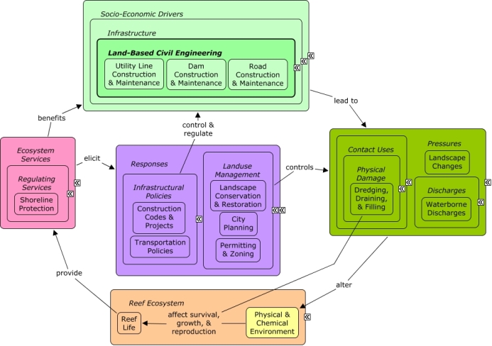
Land-Based Civil Engineering includes the design, construction, and maintenance of engineering projects that provide physical public infrastructure, including highways, dams, and utility lines.
CMap
CMap Description
Land-based civil engineering creates pressures primarily through activities related to the construction and maintenance of physical infrastructure, leading to landscape changes (including devegetation, impervious surfaces, and soil disturbance) that can affect rates of pollutant runoff. In coastal areas, development may require shoreline armoring or dredging activities, which can directly impact coastal vegetation and alter patterns of waterflow. Civil engineering & construction projects and the physical infrastructure they create benefit from shoreline protection, as well as indirectly from other ecosystem services that improve the well-being of sectors (such as tourism & recreation) that drive coastal development. City planning can reduce impacts of development through use of construction codes, permitting and zoning. Transportation policies can influence location and intensity of road development. Landscape restoration, such as hydroseeding, may be used to reduce runoff along roads or other disturbed areas.Citations
More than 50 citations. Click here to load.
| Citation | Year | Study Location | Study Type | Database Topics |
|---|
Management Options
| Management Option | Description | Sources | Database Topics |
|---|---|---|---|
| Agriculture & Aquaculture: Hydroseeding High Risk Soils | Hydroseeding is a process that creates a slurry of seeds, water, and mulch. This slurry can be applied with the use of trucks, trailers, and even aircrafts. This method is particularly useful because it promotes quick germination and reduces erosion. It is especially beneficial to use this method where there is a vastness of bare soil due to clearing vegetation for roads, homes, and farming. Higher elevations are typically steeper and often experience heavy rainfall, and ultimately an extreme amount of erosion occurs if soil is bare. Erosion from the highlands can fill the reservoirs in the drainage basin with sediment. Using hydroseeding would increase vegetation and ultimately the stabilization of the soil. Also, increased vegetation through hydroseeding would help with infiltration rates because the roots would aerate the soil. | Center for Watershed Protection. 2008. Guanica Bay watershed management plan. Natural Resources Conservation Service. 1999. Temporary Seeding. NRCS Planning and Design Manual. U.S. Depatrment of Agriculture. |
Agriculture; Agriculture, Aquaculture, & Forestry Policies; Biological Monitoring & Restoration; Civil Engineering & Construction; Construction Codes & Projects; Deforestation & Devegetation; Ditching & Soil Disturbance; Ecosystem Monitoring & Restoration; Environmental Monitoring & Restoration; Food & Energy Policies; Food & Raw Materials; Forestry; Infrastructure; Land-Based Civil Engineering; Landscape Changes; Landscape Conservation & Restoration; Landuse Management; Mining; Mining Policies; Reef Life; Sediment |
| Damage Assessment, Documentation & Response: Respond to Natural Resource Injuries from Coastal Construction & Development | This involves assessing coral, seagrass, and hard bottom substrate that is impacted during coastal construction repair or alternation. If unacceptable damages are occurring this information will be useful in future permit decision making. If infringements have occurred, this information may be useful for compensatory mitigation and liability for restoration of those natural resources injured. | NOAA Marine Sanctuary Program. 2007. Florida Keys National Marine Sanctuary revised management plan. National Ocean Service, Key West, FL. |
Biological Monitoring & Restoration; Civil Engineering & Construction; Coastal Development; Coastal Engineering; Construction Codes & Projects; Docks & Marinas; Dredging Regulations; Dredging, Draining, & Filling; Ecosystem Monitoring & Restoration; Environmental Monitoring & Restoration; Impervious Surfaces; Infrastructural Policies; Infrastructure; Land-Based Civil Engineering; Landscape Changes; Mangroves; Mitigation; Permitting & Zoning; Physical Damage; Physical Variables; Ports & Harbors; Reef Habitat; Remediation; Resource Use Management; Seagrasses; Shoreline Armoring; Special Use Permitting; Utilities; Utility Line Construction & Maintenance; Wetland & Reef Restoration; Wetlands |
| Energy Policy & Development: Develop Offshore Wind and Hydrokinetic Alternative Energies | Policies encouraging or authorizing construction of offshore facilities are evolving, and there are many sides to the issue of how to best manage them. Alternative energies are desirable and would reduce the dependence on fossil fuel resources. However, hydrokinetic technologies are just becoming viable, meaning long term impacts are still unknown. Facilitative policies reduce barriers for alternative energy development or increase barriers or costs for incumbent technologies. These include research and innovation policies, technology improvement subsidies, market based policies that internalize externalities, and regulatory changes that simplify the permitting process. | Energy Efficiency & Renewable Energy. 2009. Report to Congress on the Potential Environmental Effects of Marine and Hydrokinetic Energy Technologies. Department of Energy. Portman, M.E. 2010. Marine Renewable Energy Policy: Some US and International Perspectices Compared. Oceanography 23:98-105. |
Artificial Habitat; Biological Addition; Construction Codes & Projects; Economic Markets & Policies; Energy Policy & Development; Funding & Incentives; Infrastructural Policies; Natural Gas & Electric Power; Oil & Gas Industry; Permitting & Zoning; Petroleum Spills; Physical Variables; Point Source Discharges; Provisioning Services; Seawater Flow; Utilities; Utility Line Construction & Maintenance; Utility Policies |
| Landuse Management: Mine Reclamation | Lands disturbed by mining must be reclaimed to their Approximate Original Contour (AOC). Mine operators must backfill, compact, and grade in order to restore the AOC of the land with all highwalls, spoil piles, and depressions eliminated. Spoil material is prone to erosion, and may carry various disturbed toxics into groundwater if not properly managed. Temporary roads and impervious surfaces may have also been constructed for mining purposes. | Natural Resources Conservation Service. 2011. National Handbook of Conservation Practices. U.S. Department of Agriculture. Office of Surface Mining Reclamation and Enforcement. POSTMINING LAND USE: Exceptions to Approximate Original Contour Requirements for Mountaintop Removal Operations and steep Slope Mining Operations. Washington, DC. |
Chemical Use Regulations; Civil Engineering & Construction; Coal Mining; Construction Codes & Projects; Decision Support; Deforestation & Devegetation; Discharge Limitations; Discharges; Ditching & Soil Disturbance; Ecosystem Monitoring & Restoration; Environmental Monitoring & Restoration; Environmental Monitoring, Mapping, & Scientific Research; Food & Raw Materials; Hydrologic Management; Impervious Surfaces; Infrastructural Policies; Land-Based Civil Engineering; Landscape Changes; Landscape Conservation & Restoration; Landuse Management; Manufacturing & Trade; Manufacturing & Trade Policies; Mineral, Rock, & Metal Mining; Mining; Mining Policies; Mitigation; Non-point Source Controls; Non-point Source Runoff; Physical & Chemical Water Quality Criteria; Political Pressure; Remediation; Resource Use Management; Sediment; Surface & Groundwater Flow; Toxics; Valuation; Waterborne Discharges |
| Landuse Management: Temporary Road Planning and Construction | This management option involves minimizing sediment discharges from forestry and other temporary roads through their planning and construction. Since these roads are seasonal or temporary, less time and effort is normally invested in construction. Road construction has four main phases, clearing, leveling, construction and surfacing. Construction timing should be targeted to avoid sensitive spawning periods and during low stream flow at water passes. Road surface drainage shaping requires proper moisture content, surfacing, and grading. Drainage should be installed to reduce the volume and velocity of runoff water passing over sensitive areas. Methods for road surface drainage include: broad-based dip construction, pole culverts, ditch relief culverts, road outsloping and grading, ditch and turnout construction. Roadway runoff should be prevented from flowing directly into watercourses by using turnouts, wing ditches and dips. Brush barriers, silt fences, riprap and filter strips can be used to trap sediment in runoff water. Where roads cross streams it is important to guard against erosion, as such erosion may necessitate road repairs. | Environmental Protection Agency Office of Water. 1993. Guidance Specifying Management Measures For Sources Of Nonpoint Pollution In Coastal Waters. EPA/840/B-92/002, US EPA, Washington, DC. |
Agriculture, Aquaculture, & Forestry Policies; Civil Engineering & Construction; Construction Codes & Projects; Decision Support; Deforestation & Devegetation; Discharge Limitations; Discharges; Ecosystem Monitoring & Restoration; Environmental Monitoring & Restoration; Food & Raw Materials; Forestry; Hydrologic Management; Impervious Surfaces; Infrastructural Policies; Infrastructure; Land & Air Transportation; Land-Based Civil Engineering; Landscape Changes; Landscape Conservation & Restoration; Landuse Management; Mining; Mining Policies; Non-point Source Controls; Non-point Source Runoff; Nutrients; Road Construction & Maintenance; Sediment; Transportation; Transportation Policies |
| Marine Zoning: Permitting Application & Award | This management approach is important because permits assure protection and conservation of coral resources from harmful activities and practices. Within sanctuary waters, special use permits (#157) can be used to allow scientists and others to conduct necessary work while following permitting regulations to reduce the impact of that work. General permits are often required for altering land-use, construction projects and certain discharges. To be eligible for a permit, the operator may be required to conduct impact assessments, institute best management practices and conduct monitoring of the project. Though permits are a necessary precaution, the process can be streamlined through ensuring clear submittal requirements, and reducing redundancy. Redundancy often occurs when multiple agencies must approve a permit, a single point of contact and standard, inter-agency protocols can reduce unnecessary redundancy. | NOAA Marine Sanctuary Program. 2007. Florida Keys National Marine Sanctuary revised management plan. National Ocean Service, Key West, FL. |
Biological Addition; Biological Harvest; Building & Home Construction; Coastal Development; Collaboration & Partnering; Cultural Policies; Discharges; Dredging, Draining, & Filling; Impervious Surfaces; Land-Based Civil Engineering; Landscape Changes; Landuse Management; Permitting & Zoning; Physical Damage; Point Source Discharges; Public Administration; Resource Use Management; Scientific Research; Security & Public Administration Policies; Special Use Permitting |
| Monitor & Research: Research Historical Hydrology | This activity involves a historical assessment of the hydrology of the surrounding water area around the sanctuary as it has affected water quality and biological communities within the sanctuary. It will clarify the role of freshwater inflows and water quality from local freshwater bodies. Also, this activity will examine the effects of structural modification and changes in quality, quantity, timing and distribution of freshwater releases from existing structures and will examine land-based practices affecting the water quality of runoff. | NOAA Marine Sanctuary Program. 2007. Florida Keys National Marine Sanctuary revised management plan. National Ocean Service, Key West, FL. |
Applied Chemicals; Chemical Variables; Coastal Development; Coastal Engineering; Dam Construction & Maintenance; Deforestation & Devegetation; Discharge Limitations; Discharges; Ditching & Soil Disturbance; Dredging, Draining, & Filling; Ecosystem Monitoring & Restoration; Environmental Monitoring & Restoration; Environmental Monitoring, Mapping, & Scientific Research; Hydrologic Management; Impervious Surfaces; Infrastructural Policies; Landscape Changes; Landuse Management; Physical Variables; Salinity; Seawater Flow; Shoreline Armoring; Stormwater Management; Surface & Groundwater Flow; Water; Water Depth & Sea Level; Water Transportation; Waterborne Discharges |
| Regulatory Review and Development: Evaluate Dredging Regulations | Dredging is oftentimes prohibited with certain exceptions. Dredging regulation often falls under other controls over the alteration of the seabed, discharging or depositing materials. At times dredging is necessary for navigation or other activities, necessitating .permitting mechanisms for allowing otherwise prohibited activities. Revising the regulations to help eliminate negative dredge-and-fill activities within a certain distance of corals would be beneficial because it would help promote the reestablishment of sensitive benthic communities. Reservoirs may require periodic dredging to remove sediment that may have collected. | NOAA Marine Sanctuary Program. 2007. Florida Keys National Marine Sanctuary revised management plan. National Ocean Service, Key West, FL. |
Beach & Land Formation; Beaches & Nature Parks; Biological Monitoring & Restoration; Coastal Engineering; Construction Codes & Projects; Dam Construction & Maintenance; Decision Support; Discharge Limitations; Docks & Marinas; Dredging Regulations; Dredging, Draining, & Filling; Ecosystem Monitoring & Restoration; Hydrologic Management; Mining; Mining Policies; Physical Damage; Point Source Discharges; Ports & Harbors; Provisioning Services; Resource Use Management; Sand & Rock Production; Security & Public Administration Policies; Special Use Permitting; Substrate; Transportation; Utility Line Construction & Maintenance; Water Transportation |
| Resource Use Management: Marine Heritage Resource Protections | This management option involves protecting underwater items/sites that have historical, cultural, archaeological, or paleontological significance. This response advocates permits for action that may degrade the resource. This can be accomplished through creating an MHR field unit, monitoring MHR site degradation, and evaluating excavation and mitigation techniques. Field units can help conduct field research and coordinated, permitted research activities. Experts relating to archaeological research underwater can also be hired with additional funding. Through evaluation of excavation techniques, new technologies can be suggested such as: turbidity screens, sediment removal equipment, and seagrass restoration/relocation protocols to lead to less disturbance. Inventory and decision tools can also be used in the aid of Maritime Heritage Resource protection. | NOAA Marine Sanctuary Program. 2007. Florida Keys National Marine Sanctuary revised management plan. National Ocean Service, Key West, FL. |
Civil Engineering & Construction; Construction Codes & Projects; Cultural Policies; Cultural Protections; Cultural Services; Decision Support; Designated Uses; Dredging Regulations; Dredging, Draining, & Filling; Ecosystem Services; Educational & Research Opportunities; Existence Value & Sense of Place; Mitigation; Physical Damage; Pipelines; Reef Life; Resource Use Management; Seagrasses; Security & Public Administration Policies; Special Use Permitting; Tourism & Recreation Policies; Utility Line Construction & Maintenance; Valuation; Wetlands |
| Stormwater BMPs: Biological Stormwater Filtration | This method attempts to reduce the negative impacts of stormwater runoff through implementing engineering techniques that allow natural processes and plants to act as filters. Such techniques would include using grass parking and turf covered swales. Many of these techniques, such as reversed elevations for planted areas in parking lots, can demonstrate benefits both as natural filters and for the vegetation that are used since it eliminates the need to water them with irrigation systems. | NOAA Marine Sanctuary Program. 2007. Florida Keys National Marine Sanctuary revised management plan. National Ocean Service, Key West, FL. Natural Resources Conservation Service. 2011. National Handbook of Conservation Practices. U.S. Department of Agriculture. Natural Resources Conservation Service. Basic Biofiltration Swale. Urban BMP's - Water Runoff Management Accessed 3/23/2011. Natural Resources Conservation Service. Bioretention System. Urban BMP's - Water Runoff Management Accessed 3/23/2011. Natural Resources Conservation Service. Constructed Wetland. Urban BMP's - Water Runoff Management Accessed 3/23/2011. Natural Resources Conservation Service. Filter Strips. Urban BMP's - Water Runoff Management Accessed 3/23/2011. Natural Resources Conservation Service. Reversed Elevations System for Parking Lots and Planting Areas. Urban BMP's - Water Runoff Management Accessed 3/23/2011. Natural Resources Conservation Service. Riparian Forest Buffer. Urban BMP's - Water Runoff Management Accessed 3/23/2011. Natural Resources Conservation Service. Roadway Landscape Treatment System. Urban BMP's - Water Runoff Management Accessed 3/23/2011. Natural Resources Conservation Service. Wet Biofiltration Swale. Urban BMP's - Water Runoff Management Accessed 3/23/2011. Natural Resources Conservation Service. Wet Pond Design. Urban BMP's - Water Runoff Management Accessed 3/23/2011. Natural Resources Conservation Service. Wet Swale. Urban BMP's - Water Runoff Management Accessed 3/23/2011. Water Environment Research Foundation, American Society of Civil Engineers, U.S. Environmental Protection Agency, Federal Highway Administration, American Public Works Association, editor. 2008. Overview of Performance by BMP Category and Common Pollutant Type. International Stormwater Best Management Practices (BMP) Database [1999-2008]. Leisenring, M., Clary, J., Stephenson, J., and Hobson, P. 2010. International Stormwater Best Management Practices (BMP) Database Pollutant Category Summary: Nutrients. Geosyntec Consultants, Inc. |
Applied Chemicals; Building & Home Construction; Chemical Variables; City Planning; Civil Engineering & Construction; Climate; Construction Codes & Projects; Deforestation & Devegetation; Discharge Limitations; Discharges; Ditching & Soil Disturbance; Fertilizer & Pesticide Use; Golf Course Operations; Impervious Surfaces; Infrastructure; Irrigation; Land-Based Civil Engineering; Landscape Changes; Landscape Conservation & Restoration; Landscaping & Household Services; Landuse Management; Non-point Source Controls; Non-point Source Runoff; Nutrient & Contaminant Processing; Physical Variables; Point & Mobile Source Controls; Point Source Discharges; Primary Production; Road Construction & Maintenance; Sediment; Storms & Hurricanes; Stormwater Management; Substrate; Supporting Services; Surface & Groundwater Flow; Toxics; Utilities; Waste Management; Waste Management Policies; Wastewater Discharge; Water; Waterborne Discharges |
| Stormwater BMPs: Biological Stormwater Retention/Detention | This method attempts to reduce the negative impacts of stormwater runoff through implementation of natural structures that retain runoff water for further treatment or controlled release. These structures are typically characterized as retention ponds and incorporate natural vegetation such as grass. These ponds may be dry, or may drain into nearby wetlands. | Natural Resources Conservation Service. 2011. National Handbook of Conservation Practices. U.S. Department of Agriculture. Natural Resources Conservation Service. Dry Extended Detention Ponds. Urban BMP's - Water Runoff Management Accessed 3/23/2011. Poresky, A., Clary, J., Strecker, E., and Earles, A. 2011. International Stormwater Best Management Practices (BMP) Database. Technical Summary: Volume Reduction. Geosyntec Consultants. |
Applied Chemicals; Chemical Variables; City Planning; Civil Engineering & Construction; Discharge Limitations; Discharges; Hydrologic Management; Infrastructural Policies; Irrigation; Land-Based Civil Engineering; Landscape Changes; Landscape Conservation & Restoration; Landuse Management; Non-point Source Controls; Non-point Source Runoff; Nutrient & Contaminant Processing; Physical Variables; Point & Mobile Source Controls; Point Source Discharges; Primary Production; Sediment; Storms & Hurricanes; Stormwater Management; Substrate; Supporting Services; Surface & Groundwater Flow; Toxics; Utilities; Utility Policies; Waste Management; Waste Management Policies; Wastewater Discharge; Water; Waterborne Discharges |
| Stormwater BMPs: Sustained Reservoir Minimum Release of Minimum Baseflow to Sustain Aquatic Habitat | In some regions, even high intensity rivers (e.g. Rio Loco, Puerto Rico) are seasonal, drying for long enough to kill aquatic vegetation. Creating a constant baseflow would help sustain aquatic life and ultimately help to process nutrients. High intensity rivers are already prone to extreme channel erosion from the high flow rates, this erosion is even greater without any benthic biota to hold sediment on the river bottom. Restricting the release of reservoir water to that required to maintain aquatic biota would reduce the intensity of flow, stabilize the river bottom, create habitat and naturally process nutrients that could potentially contribute to eutrophication out on the coral reef. | Center for Watershed Protection. 2008. Guanica Bay watershed management plan. Natural Resources Conservation Service. 2011. National Handbook of Conservation Practices. U.S. Department of Agriculture. |
Algae; Biological Monitoring & Restoration; Climate; Dam Construction & Maintenance; Discharge Limitations; Discharges; Ditching & Soil Disturbance; Drinking Water Supply; Ecosystem Monitoring & Restoration; Hydrologic Management; Infrastructural Policies; Infrastructure; Land-Based Civil Engineering; Landscape Changes; Landuse Management; Nutrient & Contaminant Processing; Physical Variables; Point Source Discharges; Pressures; Primary Production; Reef Habitat; Reef Life; Regulating Services; Storms & Hurricanes; Stormwater Management; Surface & Groundwater Flow; Utilities; Waste Management; Water; Waterborne Discharges; Wetland & Reef Restoration; Wetlands |
| Stormwater BMPs: Rainwater Collection Systems | Creating a rainwater collection system (either through policy change or the initiative of homeowners) would help in many ways. These systems would utilize water in an efficient manner. It would reduce the pressure of water as a finite resource. Water would be collected and utilized before it reaches the ground. Once rain falls to the ground, it picks up nutrients, chemicals, and pathogens on the ground and transports them in the form of runoff. Eventually this contaminated stormwater runoff enters water resources through the drainage basin. Collecting a considerable amount of water would prevent contamination of that water, and allow for it to be usable. Also, it would reduce the amount of water that is lost when it is contaminated as runoff. An overall reduced amount of stormwater runoff would reduce the amount of contaminants that would harm corals. | Center for Watershed Protection. 2008. Guanica Bay watershed management plan. Natural Resources Conservation Service. Cisterns used for water harvesting. Urban BMP's - Water Runoff Management Accessed 3/18/2011. Leisenring, M., Clary, J., Stephenson, J., and Hobson, P. 2010. International Stormwater Best Management Practices (BMP) Database Pollutant Category Summary: Nutrients. Geosyntec Consultants, Inc. |
Applied Chemicals; Building & Home Construction; Chemical Variables; City Planning; Civil Engineering & Construction; Cleaner & Solvent Use; Climate; Construction Codes & Projects; Deforestation & Devegetation; Discharge Limitations; Discharges; Ditching & Soil Disturbance; Drinking Water Supply; Fertilizer & Pesticide Use; Food & Energy Policies; Impervious Surfaces; Infrastructural Policies; Infrastructure; Irrigation; Land-Based Civil Engineering; Landscape Changes; Landscaping & Household Services; Landuse Management; Non-point Source Controls; Non-point Source Runoff; Physical Variables; Point & Mobile Source Controls; Point Source Discharges; Sediment; Shelter; Storms & Hurricanes; Stormwater Management; Substrate; Surface & Groundwater Flow; Toxics; Utilities; Utility Policies; Waste Management; Waste Management Policies; Wastewater Discharge; Water; Water Utilities Policies; Waterborne Discharges |
| Stormwater BMPs: Structural Stormwater Retention/Detention | This method attempts to reduce the negative impacts of stormwater runoff through implementation of engineering structures that retain runoff water for further treatment or controlled release. Water collection can be selective, targeting the first flush of water, which is typically the most polluted. Water retention has the additional benefit of later release at a place and time when the water is needed (e.g. for irrigation). Rainwater Collection Systems (#11) can be an important water resource in areas where freshwater is limited. | Natural Resources Conservation Service. 2011. National Handbook of Conservation Practices. U.S. Department of Agriculture. Natural Resources Conservation Service. Combined Infiltration/Detention Basin. Urban BMP's - Water Runoff Management Accessed 3/23/2011. Natural Resources Conservation Service. Detention Devices for Dry/Wet Ponds. Urban BMP's - Water Runoff Management Accessed 3/23/2011. Natural Resources Conservation Service. Dry Extended Detention Ponds. Urban BMP's - Water Runoff Management Accessed 3/23/2011. Leisenring, M., Clary, J., Stephenson, J., and Hobson, P. 2010. International Stormwater Best Management Practices (BMP) Database Pollutant Category Summary: Nutrients. Geosyntec Consultants, Inc. Poresky, A., Clary, J., Strecker, E., and Earles, A. 2011. International Stormwater Best Management Practices (BMP) Database. Technical Summary: Volume Reduction. Geosyntec Consultants. Natural Resources Conservation Service. 2010. Stormwater Runoff Controls. U.S. Depatrment of Agriculture. Natural Resources Conservation Service. 2008. Water and Sediment Control Basin. CODE 638. U.S. Depatrment of Agriculture. Natural Resources Conservation Service. Water Volume Management. Urban BMP's - Water Runoff Management Accessed 3/25/2011. |
Agriculture, Aquaculture, & Forestry Policies; Applied Chemicals; Chemical Variables; City Planning; Civil Engineering & Construction; Climate; Coastal Development; Construction Codes & Projects; Deforestation & Devegetation; Discharge Limitations; Discharges; Ditching & Soil Disturbance; Hydrologic Management; Impervious Surfaces; Infrastructural Policies; Infrastructure; Land-Based Civil Engineering; Landscape Changes; Landuse Management; Non-point Source Controls; Non-point Source Runoff; Physical Variables; Point Source Discharges; Sediment; Shoreline Armoring; Storms & Hurricanes; Stormwater Management; Substrate; Surface & Groundwater Flow; Utilities; Utility Policies; Waste Management; Waste Management Policies; Wastewater Discharge; Water; Waterborne Discharges |
| Stormwater BMPs: Stormwater Pollution Reduction Through Instituting Preventitive Best Management Practices | This method focuses on reducing the amount of harmful contaminants in stormwater runoff by establishing Best Management Practices that prevent the generation of the pollutant to begin with. These BMPs include educational programs, infrastructure improvements and agricultural BMPs. Examples of educational programs would be programs that educate the public on the importance of, and how to avoid depositing hazardous wastes, such as oil, into storm drains, or how to use landscape management controls to limit the chemical and debris that from enter stormwater runoff from their personal lawns. Infrastructure improvement could include the use of alternative turnarounds and street cleaning. Agricultural practices such as roofs and covers for pesticides and equipment, or use of bedding are both preventative stormwater practices. Some additional specific practices include: controlling fertilizer application, properly using and disposing of fertilizers, pesticides, motor oil, and other harmful chemicals, debris removal, exposure reduction, minimization of pollutants, parking lot cleaning, stormwater catch basin insert, eliminate curbs and gutters, green parking, green roofs, street design and patterns, bedding. | NOAA Marine Sanctuary Program. 2007. Florida Keys National Marine Sanctuary revised management plan. National Ocean Service, Key West, FL. Natural Resources Conservation Service. 2011. National Handbook of Conservation Practices. U.S. Department of Agriculture. US EPA. Alternative Turnarounds. National Pollutant Discharge Elimination System Menu of BMPs Accessed 3/25/2011. US EPA. Eliminate Curbs and Gutters. National Pollutant Discharge Elimination System Menu of BMPs Accessed 3/25/2011. US EPA. Green Parking. National Pollutant Discharge Elimination System Menu of BMPs Accessed 3/25/2011. US EPA. Green Roofs. National Pollutant Discharge Elimination System Menu of BMPs Accessed 3/25/2011. US EPA. Street Design and Patterns. National Pollutant Discharge Elimination System Menu of BMPs Accessed 3/25/2011. Natural Resources Conservation Service. Urban BMP's - Water Runoff Management. Urban BMP's - Water Runoff Management Accessed 3/25/2011. Irrigation Association. 2010. Turf and Landscape Irrigation Best Management Practices. |
Agriculture; Applied Chemicals; Chemical Use Regulations; Chemical Variables; City Planning; Construction Codes & Projects; Discharge Limitations; Discharges; Environmental Education & Outreach; Food & Energy Policies; Food & Raw Materials; Forestry; Housing; Hydrologic Management; Infrastructural Policies; Infrastructure; Land-Based Civil Engineering; Landscape Changes; Landscape Conservation & Restoration; Landscaping & Household Services; Landuse Management; Mining; Nutrient & Contaminant Processing; Nutrients; Oil & Gas Industry; Road Construction & Maintenance; Security & Public Administration Policies; Shelter; Solid Waste Disposal; Storms & Hurricanes; Stormwater Management; Supporting Services; Toxics; Utilities; Waste Management; Waste Management Policies; Waterborne Discharges |
| Stormwater BMPs: Structural Stormwater Infiltration | This management option attempts to reduce the negative impacts of stormwater runoff through implementation of engineering structures that control the volume of surface water, facilitating faster absorption of the stormwater into the ground. Often these structures are able to infiltrate larger amounts of water faster while reducing exposure to surface sediments and pollutants. | Natural Resources Conservation Service. Combined Infiltration/Detention Basin. Urban BMP's - Water Runoff Management Accessed 3/23/2011. Leisenring, M., Clary, J., Stephenson, J., and Hobson, P. 2010. International Stormwater Best Management Practices (BMP) Database Pollutant Category Summary: Nutrients. Geosyntec Consultants, Inc. Poresky, A., Clary, J., Strecker, E., and Earles, A. 2011. International Stormwater Best Management Practices (BMP) Database. Technical Summary: Volume Reduction. Geosyntec Consultants. US EPA. EPA Infiltration BMPs. National Pollutant Discharge Elimination System Menu of BMPs Accessed 3/25/2011. |
Applied Chemicals; Chemical Variables; City Planning; Civil Engineering & Construction; Climate; Coastal Development; Construction Codes & Projects; Deforestation & Devegetation; Discharge Limitations; Discharges; Ditching & Soil Disturbance; Drinking Water Supply; Fertilizer & Pesticide Use; Hydrologic Management; Impervious Surfaces; Infrastructural Policies; Irrigation; Land-Based Civil Engineering; Landscape Changes; Landuse Management; Non-point Source Controls; Non-point Source Runoff; Point Source Discharges; Sediment; Storms & Hurricanes; Stormwater Management; Substrate; Supporting Services; Surface & Groundwater Flow; Waste Management Policies; Wastewater Discharge; Water; Waterborne Discharges |
| Stormwater BMPs: Structural Stormwater Filtration | This method attempts to reduce the negative impacts of stormwater runoff through implementation of engineering structures that trap or filter impurities out of runoff water. These include but are not limited to, using swales, filter strips, oil/water separators, oil/grit separators, and sand filters. Often structural retrofitting is coupled with biological filters/controls to direct water as desired and to fully reap the benefits of both systems. Structural filters are often incorporated into retention/detention and infiltration systems as well. One disadvantage of structural filters is that they are often higher maintenance as sand and chambers fill and clog with pollutants over time. | NOAA Marine Sanctuary Program. 2007. Florida Keys National Marine Sanctuary revised management plan. National Ocean Service, Key West, FL. Natural Resources Conservation Service. Compost Filter System. Urban BMP's - Water Runoff Management Accessed 3/23/2011. Natural Resources Conservation Service. Dry Swale. Urban BMP's - Water Runoff Management Accessed 3/23/2011. Natural Resources Conservation Service. Median Strip Infiltration Trench. Urban BMP's - Water Runoff Management Accessed 3/23/2011. Natural Resources Conservation Service. Montgomery County Water Quality Inlet. Urban BMP's - Water Runoff Management Accessed 3/23/2011. Natural Resources Conservation Service. Off-Line Infiltration Basin. Urban BMP's - Water Runoff Management Accessed 3/23/2011. Natural Resources Conservation Service. Oil/Water Separators. Urban BMP's - Water Runoff Management Accessed 3/23/2011. Natural Resources Conservation Service. Organic Sand Filter. Urban BMP's - Water Runoff Management Accessed 3/23/2011. Natural Resources Conservation Service. Peat Sand Filter. Urban BMP's - Water Runoff Management Accessed 3/23/2011. Natural Resources Conservation Service. Perimeter Sand Filter. Urban BMP's - Water Runoff Management Accessed 3/23/2011. Natural Resources Conservation Service. Pocket Sand Filter. Urban BMP's - Water Runoff Management Accessed 3/23/2011. Natural Resources Conservation Service. Rockville Water Quality Inlet. Urban BMP's - Water Runoff Management Accessed 3/23/2011. Natural Resources Conservation Service. Sediment Basin (Water Quality Enhancement). Urban BMP's - Water Runoff Management Accessed 3/23/2011. Natural Resources Conservation Service. Side-by-Side Infiltration Basin. Urban BMP's - Water Runoff Management Accessed 3/23/2011. Natural Resources Conservation Service. Surface Sand Filter. Urban BMP's - Water Runoff Management Accessed 3/23/2011. Natural Resources Conservation Service. Underground Sand Filter. Urban BMP's - Water Runoff Management Accessed 3/23/2011. Natural Resources Conservation Service. Underground Trench with Oil/Grit Chamber. Urban BMP's - Water Runoff Management Accessed 3/23/2011. Natural Resources Conservation Service. Under-the-Swale Infiltration Trench. Urban BMP's - Water Runoff Management Accessed 3/23/2011. Natural Resources Conservation Service. Water Quality Volume (WQV) Storage Tank. Urban BMP's - Water Runoff Management Accessed 3/23/2011. Water Environment Research Foundation, American Society of Civil Engineers, U.S. Environmental Protection Agency, Federal Highway Administration, American Public Works Association, editor. 2008. Overview of Performance by BMP Category and Common Pollutant Type. International Stormwater Best Management Practices (BMP) Database [1999-2008]. Leisenring, M., Clary, J., Stephenson, J., and Hobson, P. 2010. International Stormwater Best Management Practices (BMP) Database Pollutant Category Summary: Nutrients. Geosyntec Consultants, Inc. US EPA. EPA Filtration BMPs. National Pollutant Discharge Elimination System Menu of BMPs Accessed 3/25/2011. US EPA. Manufactured Products for Stormwater Inlets. National Pollutant Discharge Elimination System Menu of BMPs Accessed 3/25/2011. US EPA. Alum Injection. National Pollutant Discharge Elimination System Menu of BMPs Accessed 3/25/2011. Natural Resources Conservation Service. 2010. Stormwater Runoff Controls. U.S. Depatrment of Agriculture. Natural Resources Conservation Service. 2005. Solid/liquid Waste Separation Facility. U.S. Depatrment of Agriculture. |
Applied Chemicals; Chemical Variables; City Planning; Civil Engineering & Construction; Coastal Engineering; Construction Codes & Projects; Dam Construction & Maintenance; Discharge Limitations; Discharges; Ditching & Soil Disturbance; Food & Energy Policies; Hydrologic Management; Impervious Surfaces; Improved Technology; Infrastructural Policies; Infrastructure; Land-Based Civil Engineering; Landscape Changes; Landscape Conservation & Restoration; Landuse Management; Non-point Source Controls; Non-point Source Runoff; Physical Variables; Point & Mobile Source Controls; Point Source Discharges; Road Construction & Maintenance; Sediment; Storms & Hurricanes; Stormwater Management; Surface & Groundwater Flow; Toxics; Utilities; Utility Policies; Waste Management; Waste Management Policies; Wastewater Discharge; Waterborne Discharges |
| Water Quality Management: Treating Effluent Water Through Wetlands | Additional treatment of sewage is often a necessary management option because secondary treatment alone leaves 20,000 times more nutrients in the water than the safe limit for corals. High concentrations of nutrients in the water leads to eutrophication, and coral reefs are more sensitive to nutrient enrichment than any other coastal system. Wetlands are extremely successful at reducing nitrogen levels in water. Using natural wetlands or "living machines" to perform this task can actually be more cost effective than further sewage treatment. Each successive wetland treatment cell of the series can provide incredible levels of denitrification, and thus protect corals from nutrient enrichment. | Center for Watershed Protection. 2008. Guanica Bay watershed management plan. Natural Resources Conservation Service. 2011. National Handbook of Conservation Practices. U.S. Department of Agriculture. Natural Resources Conservation Service. 2003. Waste Treatment Lagoon. CODE 359. U.S. Depatrment of Agriculture. |
Building & Home Construction; Chemical Variables; City Planning; Civil Engineering & Construction; Coastal Development; Coastal Engineering; Deforestation & Devegetation; Discharge Limitations; Discharges; Ditching & Soil Disturbance; Infrastructural Policies; Infrastructure; Land-Based Civil Engineering; Landscape Changes; Landscape Conservation & Restoration; Landuse Management; Mangroves; Nutrient & Contaminant Processing; Nutrients; Physical Variables; Point & Mobile Source Controls; Point Source Discharges; Primary Production; Security & Public Administration Policies; Sewage Treatment; Supporting Services; Surface & Groundwater Flow; Toxics; Utilities; Utility Policies; Waste Management; Waste Management Policies; Wastewater Discharge; Waterborne Discharges; Wetlands |
| Waterway Management: Aquatic Organism Passage | This management action allows for upstream and downstream passage for fish and other aquatic organisms. The passage of these organisms is often restricted by barriers which must be modified, removed, or worked around with fishways. Sites should be evaluated for variations in discharge, tidal influence, hydraulics, geomorphic impacts, sediment transport and continuity, and organic debris movement. | Natural Resources Conservation Service. 2011. National Handbook of Conservation Practices. U.S. Department of Agriculture. |
Biological Monitoring & Restoration; Civil Engineering & Construction; Dam Construction & Maintenance; Ecosystem Monitoring & Restoration; Landscape Changes; Landuse Management; Water Resources |
| Waterway Management: Control River Volume Using Dams and Resevoirs | Constructing dams and creating reservoirs can have many affects, both positive and negative. Like smaller scale structural stormwater retention (#263), this management option retains groundwater for later controlled release. On this scale, the creation of a reservoir may require flooding of an area behind the dam that had other uses (e.g. agriculture). Proper vegetation can be used in and around the reservoir to incorporate biological filtration (#261). Slowing the release of water into rivers reduces the intensity of flow, reducing channel erosion. However, water should still be released consistently to allow for aquatic habitat to be maintained on the river bottom (#8). Lastly, with the correct infrastructure, a dam can be used as a sustainable hydroelectric energy source. | Morris, G.L., Fan, J. 1998. Reservoir Sedimentation Handbook: Design and management of dams, reservoirs, and watersheds for sustainable use. Ver. 1.04 edition. McGraw-Hill, New York, NY. Environmental Protection Agency. 2007. National Management Measures to Control Nonpoint Source Pollution from Hydromodification. EPA 841-B-07-002, Office of Water, Washington, DC. |
Civil Engineering & Construction; Climate; Dam Construction & Maintenance; Discharge Limitations; Discharges; Energy Policy & Development; Hydrologic Management; Improved Technology; Infrastructural Policies; Infrastructure; Land-Based Civil Engineering; Non-point Source Runoff; Nutrient & Contaminant Processing; Physical Variables; Point Source Discharges; Storms & Hurricanes; Stormwater Management; Utilities; Utility Policies; Waste Management; Water; Waterborne Discharges; Wetlands |
| Waterway Management: Collaborate with Projects Changing Water-Flow | Other organizations may be performing restorative freshwater projects (Everglades Restoration) or other flow altering projects (e.g. canals for small boats, agricultural irrigation etc) that affect the downstream marine management area (Florida Bay). Projects on the coast that involve hydrologic modifications (such as changing salinity) must be closely monitored in order to protect reef quality. Reefs are very sensitive systems and can only survive in a narrow salinity range. By taking an active role and monitoring freshwater flow projects, management staff can better ensure proper consideration of the impact on coastal marine environments. | NOAA Marine Sanctuary Program. 2007. Florida Keys National Marine Sanctuary revised management plan. National Ocean Service, Key West, FL. Comprehensive Everglades Restoration Plan. 2010. Comprehensive Everglades Restoration Plan: 2009 System Status Report. |
Collaboration & Partnering; Dam Construction & Maintenance; Decision Support; Discharge Limitations; Discharges; Ditching & Soil Disturbance; Ecosystem Monitoring & Restoration; Hydrologic Management; Landscape Changes; Point Source Discharges; Public Administration; Salinity; Security & Public Administration Policies; Surface & Groundwater Flow; Water Transportation; Waterborne Discharges |
| Waterway Management: Remove Previous Canal and Irrigation Infrastructure | Canal and irrigation infrastructure typically includes concrete structures to control the flow of water. These low head dams, bulkheads, concrete footers, and other structures act as constricting forces in channels. This constriction leads to debris becoming lodged and thus changing the erosive forces. In turn, banks become destabilized. Channel erosion then increases along with bed scour and sediment transport. Removing these structures and making banks more gradual has the added benefit of allowing for riparian vegetation to be planted, which acts as a natural buffer. | Center for Watershed Protection. 2008. Guanica Bay watershed management plan. |
Agriculture; Agriculture, Aquaculture, & Forestry Policies; Boat Movement; Boating Activities; City Planning; Civil Engineering & Construction; Coastal Engineering; Construction Codes & Projects; Dam Construction & Maintenance; Deforestation & Devegetation; Discharge Limitations; Discharges; Ditching & Soil Disturbance; Ecosystem Monitoring & Restoration; Environmental Monitoring & Restoration; Food & Raw Materials; Hydrologic Management; Impervious Surfaces; Infrastructural Policies; Irrigation; Land-Based Civil Engineering; Landscape Changes; Landscape Conservation & Restoration; Landuse Management; Non-point Source Controls; Physical Damage; Sediment; Shoreline Protection; Small Boats; Substrate; Surface & Groundwater Flow; Transportation; Water; Water Resources; Water Transportation; Waterborne Discharges |
| Waterway Management: Manage Canal Water Quality | This management option addresses water quality issues that may arise from nearshore, confined areas, specifically dead-end canals. This management response does not focus on wastewater discharges into canals, but instead on the hydrologic structure and orientation of the canal itself. Physical problems with canal orientation can lead to such problems as low flushing and build-up of weed wrack. This is a problem because the build-up of weed wrack consumes oxygen and releases nutrients as it decays. When combined with low flushing and circulation, dead end canals have decreased oxygen concentrations, accelerated eutrophication, and accumulate organic materials, pollutants and sediment. To improve the current canal system, management can inventory and map canals to identify high risk hotspots and candidates for future canal restoration projects. Canals are typically constructed to best suit the water access needs of local homes and businesses. Preventing high risk canals from being constructed, or placing certain requirements on their construction through permitting is one way to reduce future problem spots. Some design strategies include: Construct non-linear canals without right-angles and flared inlets oriented to prevailing winds. Instead of dead-ends, canals should include a flow through water exchange system or install mechanical pumps. Canals should be as wide as possible in relation to depth and length. Canal depth should be uniform or progressively shallower away from the parent waterbody, with sloping banks (eliminate requirements for navigable depths to shoreline). Some canal improvement strategies include: Implement weed gates, air curtains, and aeration systems. Direct all stormwater and effluent away from canal systems. Reduce bulkheading and restore native vegetative buffers (#1). Promote diversity of substrates and habitats. | NOAA Marine Sanctuary Program. 2007. Florida Keys National Marine Sanctuary revised management plan. National Ocean Service, Key West, FL. |
Applied Chemicals; Biological Monitoring & Restoration; Boat Movement; Boating Activities; Building & Home Construction; Chemical Variables; City Planning; Civil Engineering & Construction; Coastal Development; Coastal Engineering; Construction Codes & Projects; Decision Support; Deforestation & Devegetation; Discharge Limitations; Discharges; Ditching & Soil Disturbance; Docks & Marinas; Ecosystem Monitoring & Restoration; Environmental Monitoring & Restoration; Fishing Sector; Food & Energy Policies; Hydrologic Management; Improved Technology; Infrastructural Policies; Infrastructure; Land-Based Civil Engineering; Landscape Changes; Landscaping & Household Services; Landuse Management; Non-point Source Controls; Non-point Source Runoff; Nutrient & Contaminant Processing; Physical & Chemical Water Quality Criteria; Physical Damage; Physical Variables; Point & Mobile Source Controls; Point Source Discharges; Ports & Harbors; Provisioning Services; Regulating Services; Seawater Flow; Shoreline Armoring; Shoreline Protection; Small Boats; Surface & Groundwater Flow; Tourism & Recreation; Transportation; Transportation Policies; Utilities; Utility Policies; Waste Management; Waste Management Policies; Wastewater Discharge; Water; Water Depth & Sea Level; Water Resources; Water Transportation; Waterborne Discharges; Wetland & Reef Restoration; Wetlands |
Laws
| Legal Citation | Purpose of Law | Management Organization | Database Topics |
|---|---|---|---|
| Delegation of the Environmental Resource Program to Local Governments, 62-344 Florida Administrative Code. | (1) This chapter guides the participation of counties, municipalities and local pollution control programs in an efficient,
streamlined permitting system by setting forth the procedures and requirements for delegations of all or a part of the environmental
resource permit program from the Department and water management districts to local governments in accordance with the
provisions of Sections 373.103(8) and 373.441, F.S. This chapter also constitutes the Department�s authorization, in accordance with
Section 373.103(8), F.S., for delegations of the environmental resource permit program from the water management districts to local
governments provided that the procedures for delegation contained in this chapter are followed by the Districts. Delegations from
the Department and Districts shall be for the respective environmental resource permit program responsibilities of the Department
and the Suwannee River, St. Johns River, Southwest Florida and South Florida Water Management Districts, as set forth in
operating agreements listed in Chapter 62-113, F.A.C. Delegation agreements between the Department and local governments shall
be listed in Chapter 62-113, F.A.C., and delegation agreements between the Districts and local governments shall be listed in
Chapters 40B-1, 40C-1, 40D-1, and 40E-1, F.A.C.
(2) Nothing in this chapter shall preclude the Department, Districts, and local governments from entering into contracts or
interagency agreements as provided by law.
(3) Except as specifically provided in this chapter, nothing herein shall prevent a local government from adopting and
implementing an environmental regulatory program pursuant to its own authority.
(4) It is an objective of the Department and Districts to protect the functions of entire ecological systems, as defined and
developed in the programs, rules and plans of the Department and water management districts. It is the intent of the Department and
Districts that any local government receiving delegation of all or a portion of the environmental resource program carry out that
program in a manner consistent with this objective. This paragraph shall not be construed or applied as additional permitting criteria
beyond those adopted by the reviewing agency or the local government. Application to Coral Reefs:In theory, delegating stormwater pond construction and wetland functional determinations, as well as most otrher issues related to stormwater and wetlands, to local government will produce more efficient permitting and oversight. Therefore, treated water that is discharged and reaches any ecosystem should contain less contamination than the same water if it had not treated. Legislative Actions: Comments:Guides the participation of counties, municipalities and local pollution control programs in an efficient, streamlined permitting system by setting forth the procedures and requirements for delegations of all or a part of the environmental resource permit program from the Department and water management districts to local governments |
Florida State Department of Environmental Protection Jurisdiction: State Coastal Waters |
Applied Chemicals; Building & Home Construction; Construction Codes & Projects; Manufacturing & Trade; Nutrient & Contaminant Processing; Nutrients; Physical & Chemical Water Quality Criteria; Point Source Discharges; Road Construction & Maintenance; Sediment; Waste Management Policies; Wastewater Discharge |
| Delineation of the landward extent of wetlands and surface waters, 62-340 Florida Administrative Code Annotated (2000). | The Rule's intent is to provide a unified statewide methodology for the delineation of the extent of wetlands to satisfy the mandate of Section 373.421, F. S. Application to Coral Reefs:Preservation of wetlands will allow them to continue to function as buffers for sediment and contaminant control keeping them from reaching estuarine and marine waters and eventually habitats including coral reefs. Legislative Actions:The Rule is administrative and methodological for delineation purposes. Comments: |
Florida Department of Environmental Protection Jurisdiction: State Coastal Waters; US State Waters; Designated Marine Areas |
Agriculture, Aquaculture, & Forestry Policies; Coastal Development; Dam Construction & Maintenance; Docks & Marinas; Dredging Regulations; Drinking Water Supply; Energy Policy & Development; Finfish & Shellfish Stock; Fish; Invertebrates; Landuse Management; Molluscs; Pipelines; Ports & Harbors; Road Construction & Maintenance; Sediment; Sewage Treatment; Shoreline Armoring; Small Boats; Solid Waste Disposal; Utility Line Construction & Maintenance; Wetlands |
| Environmental resource permitting procedures, 62-343 Florida Administrative Code Annotated (2003). | The rule provides the procedural requirements for processing environmental resource permits and obtaining formal determinations of the landward extent of wetlands and surface waters. Application to Coral Reefs:Requiring permits for projects related to environmental resources will indirectly protect environmental habitats. The permits are related to stormwater managemnt systems including discharges to wetlands. The permit conditions can limit toxics, nutrients and sediment that would be discharged to the environment if the rule were not in place. Legislative Actions:The rule is procedural and does not have fines or penalties. Comments: |
Florida Department of Environmental Protection Jurisdiction: State Coastal Waters |
Agriculture, Aquaculture, & Forestry Policies; Building & Home Construction; Construction Codes & Projects; Dam Construction & Maintenance; Docks & Marinas; Dredging Regulations; Dredging, Draining, & Filling; Finfish & Shellfish Stock; Landuse Management; Mangroves; Nutrient & Contaminant Processing; Oil & Gas Research & Exploration; Permitting & Zoning; Point Source Discharges; Ports & Harbors; Road Construction & Maintenance; Seagrasses; Sediment; Surface & Groundwater Flow; Waste Management Policies; Wastewater Discharge; Wetlands |
| Environmental Resource Permitting, 62-330 Florida Administrative Code Annotated (2005). | Under the Chapter, DEP exercises its independent authority under Part IV, Chapter 373, F.S., to regulate surface water management systems, including activities in, on or over wetlands or other surface waters. The term "surface water management system" or "system" include stormwater mangement systems, dams, impoundments, reservoirs, appurtenant works, or works, or any combination thereof, and includes dredging and filling. "Dredging" means excavation, by any means, in surface waters or wetlands Application to Coral Reefs:Regulating stormwater management systems, dams, reservoirs and dredging will contribute to controlling contaminates from entering estuarine and marine environments and protect ecosystems including coral reefs., Legislative Actions:Individual permits will contain the conditions for environmental protection. Comments: |
Florida Department of Environmental Protection Jurisdiction: State Coastal Waters; Designated Marine Areas |
City Planning; Construction Codes & Projects; Dam Construction & Maintenance; Docks & Marinas; Dredging Regulations; Dredging, Draining, & Filling; Mangroves; Nutrient & Contaminant Processing; Pipelines; Ports & Harbors; Resource Use Management; Road Construction & Maintenance; Sediment; Surface & Groundwater Flow; Utility Line Construction & Maintenance; Wastewater Discharge |
| National Environmental Policy Act of 1969 as amended through 1982,. | Declared a national policy that will encourage productive and enjoyable harmony between man and his environment : promote efforts that will prevent or eliminate damage to the environment and biosphere: stimulate the health and welfare of resources important to the Nation and establish a Council on Environmental Quality. Application to Coral Reefs:Re-athorizes NEPA of 1969. Provides additional funding. Legislative Actions:The Act potentially could protect coral reefs if the proposed federal project could have a significant impact on the reef. Comments:The amendments did not add regulations to the Act |
Federal Agencies Jurisdiction: United States |
Atmospheric Emissions; Chemical Variables; Collaboration & Partnering; Complex Habitat & Resources; Dam Construction & Maintenance; Discharge Limitations; Discharges; Educational & Research Opportunities; Energy Policy & Development; Environmental Education & Outreach; Existence Value & Sense of Place; Infrastructural Policies; Landuse Management; Manufacturing & Trade; Mining; Oil & Gas Industry; Recreational Opportunities; Resource Use Management; Security; Toxics; Transportation; Waterborne Discharges |
| Proclamation No. 7399, Establishment of Virgin Islands Coral Reef National monument, 66 Federal Register 7364 (2001). | Designated 12,000 marine acres in the US Virgin Islands Application to Coral Reefs:Monuments include coral reefs thereby providing the coral reefs within the monument bondaries the same protection as the designated monument areas. Legislative Actions: Comments:Together, Proclamation 7399 and 7392 designated a total of 30,843 marine acres in the United States Virgin Isalnds as monuments. |
US Virgin Islands, Department of Planning and Natural Resources, Division of Environmental Protection Jurisdiction: US Virgin Islands |
Building & Home Construction; Commercial Fishing Boats; Designate Protected Species; Dive, Snorkeling, & Swimming Tourism; Educational & Research Opportunities; Environmental Education & Outreach; Existence Value & Sense of Place; Finfish Harvest; Fishing Sector; Invertebrate Harvest; Mangroves; Marine Protected Areas; Recreational Opportunities; Resource Use Management; Road Construction & Maintenance; Seagrasses; Small Boats; Tourism & Recreation Policies |
| Significant amendments to the Coastal Barrier Resources Act of 1982 include (1) Coastal Barrier Improvement Act of 1990, (2) Coastal Barrier Resources Reauthorization Act of 2000, (3) Coastal Barriers Resources Reauthorization Act of 2005,. | (1) Added additional areas along the Great Lakes, Puerto Rico, the Florida Keys and the Virgin Islands and established "Otherwise Protected Areas OPAs); (2) amended the guidelines for making recommendations regarding additions to the CBRS and reqired a pilot digital mapping project; (3) reauthorized CBRA and required the submission of the final digital mapping pilot project. Application to Coral Reefs:Development of coastal barrier islands can cause sedimentation, through runoff and construction activities, that could reach inshore coral reefs. Legislative Actions:Restricted most federal expenditures and financial assistance that encourage development including federal flood insurance. Comments:Recognized coastal barriers as essential habitat for many fish, water fowl and other aquatic animals |
U.S. Fish & Wildlife Service Jurisdiction: United States |
Beach & Land Formation; Coastal Development; Dam Construction & Maintenance; Existence Value & Sense of Place; Forestry; Mangroves; Seagrasses; Seawater Flow; Shoreline Protection |
| Surface water quality standards in table format, 62.302.500 Florida Administrative Code Annotated (2008). | This section of Chapter 62-302 presents the water quality standards in a tabular format for each class of waters of the State. Application to Coral Reefs: Legislative Actions: Comments: |
Florida Department of Environmental Protection Jurisdiction: State Coastal Waters; US State Waters |
Agriculture, Aquaculture, & Forestry Policies; Building & Home Construction; Chemical Variables; Coastal Development; Coastal Engineering; Complex Habitat & Resources; Construction Codes & Projects; Dam Construction & Maintenance; Deforestation & Devegetation; Ditching & Soil Disturbance; Docks & Marinas; Finfish & Shellfish Stock; Landuse Management; Mangroves; Permitting & Zoning; Ports & Harbors; Resource Use Management; Road Construction & Maintenance; Seagrasses; Sediment; Shoreline Armoring; Utility Line Construction & Maintenance |
| Surface water quality standards, 62-302 Florida Administrative Code Annotated (2008). | The Chapter establishes the minimum concentrations of contamination that are allowable to protect the designated uses of a waterbody. Designated uses include public drinking water supplies, propagation of fish and wildlife, agricultural, recreation, industrial, and navigation. Application to Coral Reefs:Protecting surface waters by limiting the concentration of pollutants that can be present will control the concentrations of those pollutants that will reach estuarine and marine environments, thus protecting the associated ecosystems, including coral reefs. Legislative Actions:Penalties are not presented in the Rule. Specific requirements and penalties are addrressed in individual permits. The Rule relies heavily on biocriteria including acute toxicity, chronic toxicity, Shannon-Weaver Diversity Index. Section 400 presents the classes of Florida waters; Class I potable water supplies, Class II shellfish propagation or harvesting, Class III recreation, propagation and maintenance of a healthy, well-balanced population of fish and wildlife, Class IV agricultural water supplies, Class V navigation, utility and industrial use. Comments: |
Florida Department of Environmental Protection Jurisdiction: State Coastal Waters; US State Waters; Designated Marine Areas |
Biocriteria; Biological Monitoring, Mapping, & Scientific Research; Civil Engineering & Construction; Coastal Development; Commercial Fisheries; Complex Habitat & Resources; Dam Construction & Maintenance; Deforestation & Devegetation; Designate Protected Species; Discharge Limitations; Dive, Snorkeling, & Swimming Tourism; Docks & Marinas; Dredging Regulations; Dredging, Draining, & Filling; Drinking Water Supply; Fertilizer & Pesticide Use; Finfish & Shellfish Stock; Fish; Fishing & Harvesting Management; Impervious Surfaces; Invertebrates; Irrigation; Landuse Management; Molluscs; Non-point Source Controls; Non-point Source Runoff; Nutrient & Contaminant Processing; Nutrients; Physical & Chemical Water Quality Criteria; Pipelines; Point & Mobile Source Controls; Point Source Discharges; Ports & Harbors; Recreational Fishing; Sediment; Sewage Treatment; Shoreline Armoring; Small Boats; Tourism & Recreation Policies; Toxics; Waste Management Policies |
| Surface waters of the State, Florida Administrative Code Annotated §§ Chapter 62-301 (1996). | It is the intent of this Chapter to define the landward externt of surface waters of the state. Te findings, declarations, and intentfor this Chapter are the same as those for Chapter 62-302 F. A. C. Application to Coral Reefs:By defining the landward extent of surface waters of the State using dominant plant species, the guidance in the Chapter will include wetlands and transitional zones on many occasions. Through the protection of these areas, filtration of sediment and nutrients will be maintained and two of the harmful parameters for coral reefs will be reduced. Legislative Actions:The Chapter is a guidance document and does not contain penalties. The Chapter provides a list of plant species for use with the guidance as well as the methods of calculating the areas of state waters. Comments: |
Florida Department of Environmental Protection Jurisdiction: State Coastal Waters; US State Waters; Designated Marine Areas |
Arthropods; Ballast Discharge; Beaches & Nature Parks; Biotechnology Research & Development; Building & Home Construction; Coastal Development; Docks & Marinas; Dredging Regulations; Dredging, Draining, & Filling; Finfish & Shellfish Stock; Fish; Fishing & Harvesting Management; Forestry; Invertebrates; Landscape Conservation & Restoration; Landuse Management; Mangroves; Marine Birds; Marine Vertebrates; Molluscs; Non-point Source Runoff; Nutrient & Contaminant Processing; Petroleum Spills; Pipelines; Ports & Harbors; Recreational Fishing; Resource Use Management; Sea Turtles; Seagrasses; Sediment; Shoreline Armoring; Small Boats; Surface & Groundwater Flow; Utility Line Construction & Maintenance; Wastewater Discharge; Wetlands; Whales & Dolphins |
| Uniform Mitigation Assessment Method, Florida Administrative Code Annotated §§ Chapter 62-345 (2005). | Establishes a methodology that provides a standard procedure for assessing the functions provided by wetlands and other surface waters, the amount that those functions are reduced by a proposed impact, and the amount of mitigation necessary to offset that loss. Application to Coral Reefs:Protecting wetlands provides wetland areas that can act as buffers against nutrients, pollutants and contaminants from reaching habitats including coral reefs. Legislative Actions:The Chapter is administrative and provides methods to assess wetland value and appropriate mitigation to offset impact. Comments: |
Florida Department of Environmental Protection Jurisdiction: State Coastal Waters |
Agriculture, Aquaculture, & Forestry Policies; Building & Home Construction; Civil Engineering & Construction; Coastal Development; Coastal Engineering; Complex Habitat & Resources; Construction Codes & Projects; Dam Construction & Maintenance; Docks & Marinas; Dredging Regulations; Dredging, Draining, & Filling; Finfish & Shellfish Stock; Forestry; Land-Based Civil Engineering; Landuse Management; Mangroves; Nutrient & Contaminant Processing; Oil & Gas Research & Exploration; Pipelines; Ports & Harbors; Recreational Opportunities; Resource Use Management; Road Construction & Maintenance; Seagrasses; Sediment; Shoreline Armoring; Surface & Groundwater Flow; Utility Line Construction & Maintenance; Wetlands |
| Water quality based effluent limitations, 62-650 Florida Administrative Code Annotated (1996). | To implement the provisions of Section 403.051, 403.085 through 403.088 concerning the development of effluent limitations for wastewater facilities. Application to Coral Reefs:The Florida Air and Water Pollution Act establishes that no wastes are to be discharged to any waters of the state without first being given the degree of treatment necessay to protect the beneficial uses of such water. Requiring treatment of industrial and domestic waste water indirectly protects adjoining ecosystem, such as reefs, by limiting the pollutant that reach these other systems. Legislative Actions:The Department shall not issue a permit for a discharge to waters of the state, unless the Department has established an efflent limit for those pollutants in the discharge that are present in quantities or concentrations which can be reasonably expected to cause or contribute, directly or indirectly, to a violation of any water quality standard established in rule 62-302. The effluent limit may be a technology based effluent limit (TBEL), a water quality based effluent limit (WQBEL) determined by a Level 1 process, or where applicable, a WQBEL determined by a Level 2 process. Comments: |
Florida Department of Environmental Protection Jurisdiction: US State Waters; Designated Marine Areas |
Agriculture, Aquaculture, & Forestry Policies; Applied Chemicals; Building & Home Construction; Cleaner & Solvent Use; Coal Mining; Construction Codes & Projects; Dam Construction & Maintenance; Domestic Animal Waste; Dredging, Draining, & Filling; Fertilizer & Pesticide Use; Finfish & Shellfish Stock; Fish; Food, Beverage, & Tobacco Products; Irrigation; Landuse Management; Lobster, Crab, & Shrimp; Metals, Electronics, & Machinery Products; Mineral, Rock, & Metal Mining; Non-point Source Runoff; Nutrient & Contaminant Processing; Nutrients; Physical & Chemical Water Quality Criteria; Point Source Discharges; Road Construction & Maintenance; Sediment; Sewage Treatment; Solid Waste Disposal; Utility Line Construction & Maintenance; Waste Management Policies; Wastewater Discharge; Waterborne Discharges; Wholesale & Retail Trade; Wood, Plastics, & Chemical Products |