ReefLink Database
Hydrologic Management
Hydrological management refers to responses designed to limit discharges by directly controlling the flow of water. Examples include implementing or upgrading stormwater collection systems, altering water collection or delivery from reservoirs, or projects to modify discharge from rivers.
CMap
CMap Description
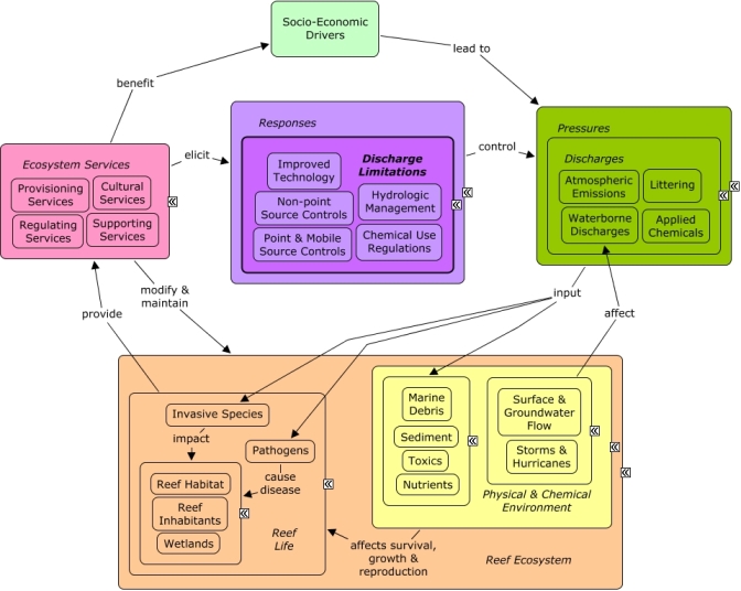
A change in the provision of ecosystem services, or a desire to improve provision of ecosystem services, may elicit responses to reduce or manage discharges of pollutants into coastal waters. Hydrological modifications may be initiated to alter patterns of water flow from rivers or stormwater that carry pollution to coastal waters. Many of the same socio-economic sectors that create pollution benefit indirectly from goods and services provided by the reef, which provides recreational opportunities and contributes to the cultural identity of the local community and drives coastal development.Citations
| Citation | Year | Study Location | Study Type | Database Topics |
|---|---|---|---|---|
| Clarke, R. D., C. M. Finelli, and E. J. Buskey. 2009. Water flow controls distribution and feeding behavior of two co-occurring coral reef fishes: II. Laboratory experiments. Coral Reefs 14-Jan. | 2009 | Field Study & Monitoring; Lab Study | Fish; Hydrologic Management; Plankton; Seawater Flow | |
| Finelli, C. M., R. D. Clarke, H. E. Robinson, and E. J. Buskey. 2009. Water flow controls distribution and feeding behavior of two co-occurring coral reef fishes: I. Field measurements. Coral Reefs 13-Jan. | 2009 | South & Central America; Belize | Field Study & Monitoring | Hydrologic Management; Plankton; Seawater Flow; Shoreline Protection |
Management Options
| Management Option | Description | Sources | Database Topics |
|---|---|---|---|
| Landuse Management: Mine Reclamation | Lands disturbed by mining must be reclaimed to their Approximate Original Contour (AOC). Mine operators must backfill, compact, and grade in order to restore the AOC of the land with all highwalls, spoil piles, and depressions eliminated. Spoil material is prone to erosion, and may carry various disturbed toxics into groundwater if not properly managed. Temporary roads and impervious surfaces may have also been constructed for mining purposes. | Natural Resources Conservation Service. 2011. National Handbook of Conservation Practices. U.S. Department of Agriculture. Office of Surface Mining Reclamation and Enforcement. POSTMINING LAND USE: Exceptions to Approximate Original Contour Requirements for Mountaintop Removal Operations and steep Slope Mining Operations. Washington, DC. |
Chemical Use Regulations; Civil Engineering & Construction; Coal Mining; Construction Codes & Projects; Decision Support; Deforestation & Devegetation; Discharge Limitations; Discharges; Ditching & Soil Disturbance; Ecosystem Monitoring & Restoration; Environmental Monitoring & Restoration; Environmental Monitoring, Mapping, & Scientific Research; Food & Raw Materials; Hydrologic Management; Impervious Surfaces; Infrastructural Policies; Land-Based Civil Engineering; Landscape Changes; Landscape Conservation & Restoration; Landuse Management; Manufacturing & Trade; Manufacturing & Trade Policies; Mineral, Rock, & Metal Mining; Mining; Mining Policies; Mitigation; Non-point Source Controls; Non-point Source Runoff; Physical & Chemical Water Quality Criteria; Political Pressure; Remediation; Resource Use Management; Sediment; Surface & Groundwater Flow; Toxics; Valuation; Waterborne Discharges |
| Landuse Management: Temporary Road Planning and Construction | This management option involves minimizing sediment discharges from forestry and other temporary roads through their planning and construction. Since these roads are seasonal or temporary, less time and effort is normally invested in construction. Road construction has four main phases, clearing, leveling, construction and surfacing. Construction timing should be targeted to avoid sensitive spawning periods and during low stream flow at water passes. Road surface drainage shaping requires proper moisture content, surfacing, and grading. Drainage should be installed to reduce the volume and velocity of runoff water passing over sensitive areas. Methods for road surface drainage include: broad-based dip construction, pole culverts, ditch relief culverts, road outsloping and grading, ditch and turnout construction. Roadway runoff should be prevented from flowing directly into watercourses by using turnouts, wing ditches and dips. Brush barriers, silt fences, riprap and filter strips can be used to trap sediment in runoff water. Where roads cross streams it is important to guard against erosion, as such erosion may necessitate road repairs. | Environmental Protection Agency Office of Water. 1993. Guidance Specifying Management Measures For Sources Of Nonpoint Pollution In Coastal Waters. EPA/840/B-92/002, US EPA, Washington, DC. |
Agriculture, Aquaculture, & Forestry Policies; Civil Engineering & Construction; Construction Codes & Projects; Decision Support; Deforestation & Devegetation; Discharge Limitations; Discharges; Ecosystem Monitoring & Restoration; Environmental Monitoring & Restoration; Food & Raw Materials; Forestry; Hydrologic Management; Impervious Surfaces; Infrastructural Policies; Infrastructure; Land & Air Transportation; Land-Based Civil Engineering; Landscape Changes; Landscape Conservation & Restoration; Landuse Management; Mining; Mining Policies; Non-point Source Controls; Non-point Source Runoff; Nutrients; Road Construction & Maintenance; Sediment; Transportation; Transportation Policies |
| Monitor & Research: Research Historical Hydrology | This activity involves a historical assessment of the hydrology of the surrounding water area around the sanctuary as it has affected water quality and biological communities within the sanctuary. It will clarify the role of freshwater inflows and water quality from local freshwater bodies. Also, this activity will examine the effects of structural modification and changes in quality, quantity, timing and distribution of freshwater releases from existing structures and will examine land-based practices affecting the water quality of runoff. | NOAA Marine Sanctuary Program. 2007. Florida Keys National Marine Sanctuary revised management plan. National Ocean Service, Key West, FL. |
Applied Chemicals; Chemical Variables; Coastal Development; Coastal Engineering; Dam Construction & Maintenance; Deforestation & Devegetation; Discharge Limitations; Discharges; Ditching & Soil Disturbance; Dredging, Draining, & Filling; Ecosystem Monitoring & Restoration; Environmental Monitoring & Restoration; Environmental Monitoring, Mapping, & Scientific Research; Hydrologic Management; Impervious Surfaces; Infrastructural Policies; Landscape Changes; Landuse Management; Physical Variables; Salinity; Seawater Flow; Shoreline Armoring; Stormwater Management; Surface & Groundwater Flow; Water; Water Depth & Sea Level; Water Transportation; Waterborne Discharges |
| Regulatory Review and Development: Evaluate Dredging Regulations | Dredging is oftentimes prohibited with certain exceptions. Dredging regulation often falls under other controls over the alteration of the seabed, discharging or depositing materials. At times dredging is necessary for navigation or other activities, necessitating .permitting mechanisms for allowing otherwise prohibited activities. Revising the regulations to help eliminate negative dredge-and-fill activities within a certain distance of corals would be beneficial because it would help promote the reestablishment of sensitive benthic communities. Reservoirs may require periodic dredging to remove sediment that may have collected. | NOAA Marine Sanctuary Program. 2007. Florida Keys National Marine Sanctuary revised management plan. National Ocean Service, Key West, FL. |
Beach & Land Formation; Beaches & Nature Parks; Biological Monitoring & Restoration; Coastal Engineering; Construction Codes & Projects; Dam Construction & Maintenance; Decision Support; Discharge Limitations; Docks & Marinas; Dredging Regulations; Dredging, Draining, & Filling; Ecosystem Monitoring & Restoration; Hydrologic Management; Mining; Mining Policies; Physical Damage; Point Source Discharges; Ports & Harbors; Provisioning Services; Resource Use Management; Sand & Rock Production; Security & Public Administration Policies; Special Use Permitting; Substrate; Transportation; Utility Line Construction & Maintenance; Water Transportation |
| Resource Use Management: Develop Water Efficiency Initiatives | Reducing water use through cost effective water efficiency improvements can be beneficial as it reduces pressure on water as a finite resource and saves money. There are several ways water efficiency can be promoted. Some Water Efficiency BMPs recommended by the EPA include: Water Management Planning; Information and Education Programs; Distribution System Audits, Leak Detection and Repair; Water-Efficient Landscaping, Water-Efficient Irrigation; Toilets and Urinals; Faucets and Showerheads; Boiler/Steam Systems; Single-Pass Cooling Equipment; Cooling Tower Management; Commercial Kitchen Equipment; Laboratory/ Medical Equipment; Other Water Intensive Processes; Alternative Water Sources. One of the ways the US government has promoted Water Efficiency Initiatives is through Executive order 13123 which places certain water use reduction requirements on Federal Agencies. There are also existing funding and incentives for non-government sectors. Project funding comes in many forms, such as appropriations, energy savings performance contract (ESPC) and Utility Energy Service Contract (UESCs) programs; ratepayer incentive programs such as rebates from public benefit funds or utilities; and the retention of energy and water cost savings. | US Department of Energy. 2008. Establishing Baseline and Meeting Water Conservation Goals of Executive Order 13423. Environmental Protection Agency. Federal Water Efficiency Best Management Practices. Federal Energy Management Program Accessed 7/12/2011. |
Agriculture; Collaboration & Partnering; Designated Uses; Discharge Limitations; Discharges; Drinking Water Supply; Environmental Education & Outreach; Funding & Donations; Funding & Incentives; Hydrologic Management; Irrigation; Landscaping & Household Services; Natural Gas & Electric Power; Resource Use Management; Surface & Groundwater Flow; Textiles & Apparel; Utilities; Utility Policies; Water; Water Resources; Water Utilities Policies; Waterborne Discharges |
| Restoration: Land Reclamation Integrating Toxic Discharge Controls | This option aims to eliminate unsightly residues, reduce erosion and control acid or otherwise toxic aqueous discharges from abandoned coal mines, coalmine waste or other types of land change. For toxic mine drainage, preventative actions include mine sealing, infiltration control, day lighting, and neutralization with alkaline material such as hydrated lime. Which action to take relies heavily on groundwater and runoff in the region of the mine. | Natural Resources Conservation Service. 2011. National Handbook of Conservation Practices. U.S. Department of Agriculture. |
Aquaculture; Coal Mining; Discharge Limitations; Discharges; Ditching & Soil Disturbance; Hydrologic Management; Mineral, Rock, & Metal Mining; Mining; Mining Policies; Non-point Source Controls; Ocean Acidity; Surface & Groundwater Flow; Toxics; Waterborne Discharges |
| Stormwater BMPs: Structural Stormwater Infiltration | This management option attempts to reduce the negative impacts of stormwater runoff through implementation of engineering structures that control the volume of surface water, facilitating faster absorption of the stormwater into the ground. Often these structures are able to infiltrate larger amounts of water faster while reducing exposure to surface sediments and pollutants. | Natural Resources Conservation Service. Combined Infiltration/Detention Basin. Urban BMP's - Water Runoff Management Accessed 3/23/2011. Leisenring, M., Clary, J., Stephenson, J., and Hobson, P. 2010. International Stormwater Best Management Practices (BMP) Database Pollutant Category Summary: Nutrients. Geosyntec Consultants, Inc. Poresky, A., Clary, J., Strecker, E., and Earles, A. 2011. International Stormwater Best Management Practices (BMP) Database. Technical Summary: Volume Reduction. Geosyntec Consultants. US EPA. EPA Infiltration BMPs. National Pollutant Discharge Elimination System Menu of BMPs Accessed 3/25/2011. |
Applied Chemicals; Chemical Variables; City Planning; Civil Engineering & Construction; Climate; Coastal Development; Construction Codes & Projects; Deforestation & Devegetation; Discharge Limitations; Discharges; Ditching & Soil Disturbance; Drinking Water Supply; Fertilizer & Pesticide Use; Hydrologic Management; Impervious Surfaces; Infrastructural Policies; Irrigation; Land-Based Civil Engineering; Landscape Changes; Landuse Management; Non-point Source Controls; Non-point Source Runoff; Point Source Discharges; Sediment; Storms & Hurricanes; Stormwater Management; Substrate; Supporting Services; Surface & Groundwater Flow; Waste Management Policies; Wastewater Discharge; Water; Waterborne Discharges |
| Stormwater BMPs: Structural Stormwater Filtration | This method attempts to reduce the negative impacts of stormwater runoff through implementation of engineering structures that trap or filter impurities out of runoff water. These include but are not limited to, using swales, filter strips, oil/water separators, oil/grit separators, and sand filters. Often structural retrofitting is coupled with biological filters/controls to direct water as desired and to fully reap the benefits of both systems. Structural filters are often incorporated into retention/detention and infiltration systems as well. One disadvantage of structural filters is that they are often higher maintenance as sand and chambers fill and clog with pollutants over time. | NOAA Marine Sanctuary Program. 2007. Florida Keys National Marine Sanctuary revised management plan. National Ocean Service, Key West, FL. Natural Resources Conservation Service. Compost Filter System. Urban BMP's - Water Runoff Management Accessed 3/23/2011. Natural Resources Conservation Service. Dry Swale. Urban BMP's - Water Runoff Management Accessed 3/23/2011. Natural Resources Conservation Service. Median Strip Infiltration Trench. Urban BMP's - Water Runoff Management Accessed 3/23/2011. Natural Resources Conservation Service. Montgomery County Water Quality Inlet. Urban BMP's - Water Runoff Management Accessed 3/23/2011. Natural Resources Conservation Service. Off-Line Infiltration Basin. Urban BMP's - Water Runoff Management Accessed 3/23/2011. Natural Resources Conservation Service. Oil/Water Separators. Urban BMP's - Water Runoff Management Accessed 3/23/2011. Natural Resources Conservation Service. Organic Sand Filter. Urban BMP's - Water Runoff Management Accessed 3/23/2011. Natural Resources Conservation Service. Peat Sand Filter. Urban BMP's - Water Runoff Management Accessed 3/23/2011. Natural Resources Conservation Service. Perimeter Sand Filter. Urban BMP's - Water Runoff Management Accessed 3/23/2011. Natural Resources Conservation Service. Pocket Sand Filter. Urban BMP's - Water Runoff Management Accessed 3/23/2011. Natural Resources Conservation Service. Rockville Water Quality Inlet. Urban BMP's - Water Runoff Management Accessed 3/23/2011. Natural Resources Conservation Service. Sediment Basin (Water Quality Enhancement). Urban BMP's - Water Runoff Management Accessed 3/23/2011. Natural Resources Conservation Service. Side-by-Side Infiltration Basin. Urban BMP's - Water Runoff Management Accessed 3/23/2011. Natural Resources Conservation Service. Surface Sand Filter. Urban BMP's - Water Runoff Management Accessed 3/23/2011. Natural Resources Conservation Service. Underground Sand Filter. Urban BMP's - Water Runoff Management Accessed 3/23/2011. Natural Resources Conservation Service. Underground Trench with Oil/Grit Chamber. Urban BMP's - Water Runoff Management Accessed 3/23/2011. Natural Resources Conservation Service. Under-the-Swale Infiltration Trench. Urban BMP's - Water Runoff Management Accessed 3/23/2011. Natural Resources Conservation Service. Water Quality Volume (WQV) Storage Tank. Urban BMP's - Water Runoff Management Accessed 3/23/2011. Water Environment Research Foundation, American Society of Civil Engineers, U.S. Environmental Protection Agency, Federal Highway Administration, American Public Works Association, editor. 2008. Overview of Performance by BMP Category and Common Pollutant Type. International Stormwater Best Management Practices (BMP) Database [1999-2008]. Leisenring, M., Clary, J., Stephenson, J., and Hobson, P. 2010. International Stormwater Best Management Practices (BMP) Database Pollutant Category Summary: Nutrients. Geosyntec Consultants, Inc. US EPA. EPA Filtration BMPs. National Pollutant Discharge Elimination System Menu of BMPs Accessed 3/25/2011. US EPA. Manufactured Products for Stormwater Inlets. National Pollutant Discharge Elimination System Menu of BMPs Accessed 3/25/2011. US EPA. Alum Injection. National Pollutant Discharge Elimination System Menu of BMPs Accessed 3/25/2011. Natural Resources Conservation Service. 2010. Stormwater Runoff Controls. U.S. Depatrment of Agriculture. Natural Resources Conservation Service. 2005. Solid/liquid Waste Separation Facility. U.S. Depatrment of Agriculture. |
Applied Chemicals; Chemical Variables; City Planning; Civil Engineering & Construction; Coastal Engineering; Construction Codes & Projects; Dam Construction & Maintenance; Discharge Limitations; Discharges; Ditching & Soil Disturbance; Food & Energy Policies; Hydrologic Management; Impervious Surfaces; Improved Technology; Infrastructural Policies; Infrastructure; Land-Based Civil Engineering; Landscape Changes; Landscape Conservation & Restoration; Landuse Management; Non-point Source Controls; Non-point Source Runoff; Physical Variables; Point & Mobile Source Controls; Point Source Discharges; Road Construction & Maintenance; Sediment; Storms & Hurricanes; Stormwater Management; Surface & Groundwater Flow; Toxics; Utilities; Utility Policies; Waste Management; Waste Management Policies; Wastewater Discharge; Waterborne Discharges |
| Stormwater BMPs: Stormwater Pollution Reduction Through Instituting Preventitive Best Management Practices | This method focuses on reducing the amount of harmful contaminants in stormwater runoff by establishing Best Management Practices that prevent the generation of the pollutant to begin with. These BMPs include educational programs, infrastructure improvements and agricultural BMPs. Examples of educational programs would be programs that educate the public on the importance of, and how to avoid depositing hazardous wastes, such as oil, into storm drains, or how to use landscape management controls to limit the chemical and debris that from enter stormwater runoff from their personal lawns. Infrastructure improvement could include the use of alternative turnarounds and street cleaning. Agricultural practices such as roofs and covers for pesticides and equipment, or use of bedding are both preventative stormwater practices. Some additional specific practices include: controlling fertilizer application, properly using and disposing of fertilizers, pesticides, motor oil, and other harmful chemicals, debris removal, exposure reduction, minimization of pollutants, parking lot cleaning, stormwater catch basin insert, eliminate curbs and gutters, green parking, green roofs, street design and patterns, bedding. | NOAA Marine Sanctuary Program. 2007. Florida Keys National Marine Sanctuary revised management plan. National Ocean Service, Key West, FL. Natural Resources Conservation Service. 2011. National Handbook of Conservation Practices. U.S. Department of Agriculture. US EPA. Alternative Turnarounds. National Pollutant Discharge Elimination System Menu of BMPs Accessed 3/25/2011. US EPA. Eliminate Curbs and Gutters. National Pollutant Discharge Elimination System Menu of BMPs Accessed 3/25/2011. US EPA. Green Parking. National Pollutant Discharge Elimination System Menu of BMPs Accessed 3/25/2011. US EPA. Green Roofs. National Pollutant Discharge Elimination System Menu of BMPs Accessed 3/25/2011. US EPA. Street Design and Patterns. National Pollutant Discharge Elimination System Menu of BMPs Accessed 3/25/2011. Natural Resources Conservation Service. Urban BMP's - Water Runoff Management. Urban BMP's - Water Runoff Management Accessed 3/25/2011. Irrigation Association. 2010. Turf and Landscape Irrigation Best Management Practices. |
Agriculture; Applied Chemicals; Chemical Use Regulations; Chemical Variables; City Planning; Construction Codes & Projects; Discharge Limitations; Discharges; Environmental Education & Outreach; Food & Energy Policies; Food & Raw Materials; Forestry; Housing; Hydrologic Management; Infrastructural Policies; Infrastructure; Land-Based Civil Engineering; Landscape Changes; Landscape Conservation & Restoration; Landscaping & Household Services; Landuse Management; Mining; Nutrient & Contaminant Processing; Nutrients; Oil & Gas Industry; Road Construction & Maintenance; Security & Public Administration Policies; Shelter; Solid Waste Disposal; Storms & Hurricanes; Stormwater Management; Supporting Services; Toxics; Utilities; Waste Management; Waste Management Policies; Waterborne Discharges |
| Stormwater BMPs: Structural Stormwater Retention/Detention | This method attempts to reduce the negative impacts of stormwater runoff through implementation of engineering structures that retain runoff water for further treatment or controlled release. Water collection can be selective, targeting the first flush of water, which is typically the most polluted. Water retention has the additional benefit of later release at a place and time when the water is needed (e.g. for irrigation). Rainwater Collection Systems (#11) can be an important water resource in areas where freshwater is limited. | Natural Resources Conservation Service. 2011. National Handbook of Conservation Practices. U.S. Department of Agriculture. Natural Resources Conservation Service. Combined Infiltration/Detention Basin. Urban BMP's - Water Runoff Management Accessed 3/23/2011. Natural Resources Conservation Service. Detention Devices for Dry/Wet Ponds. Urban BMP's - Water Runoff Management Accessed 3/23/2011. Natural Resources Conservation Service. Dry Extended Detention Ponds. Urban BMP's - Water Runoff Management Accessed 3/23/2011. Leisenring, M., Clary, J., Stephenson, J., and Hobson, P. 2010. International Stormwater Best Management Practices (BMP) Database Pollutant Category Summary: Nutrients. Geosyntec Consultants, Inc. Poresky, A., Clary, J., Strecker, E., and Earles, A. 2011. International Stormwater Best Management Practices (BMP) Database. Technical Summary: Volume Reduction. Geosyntec Consultants. Natural Resources Conservation Service. 2010. Stormwater Runoff Controls. U.S. Depatrment of Agriculture. Natural Resources Conservation Service. 2008. Water and Sediment Control Basin. CODE 638. U.S. Depatrment of Agriculture. Natural Resources Conservation Service. Water Volume Management. Urban BMP's - Water Runoff Management Accessed 3/25/2011. |
Agriculture, Aquaculture, & Forestry Policies; Applied Chemicals; Chemical Variables; City Planning; Civil Engineering & Construction; Climate; Coastal Development; Construction Codes & Projects; Deforestation & Devegetation; Discharge Limitations; Discharges; Ditching & Soil Disturbance; Hydrologic Management; Impervious Surfaces; Infrastructural Policies; Infrastructure; Land-Based Civil Engineering; Landscape Changes; Landuse Management; Non-point Source Controls; Non-point Source Runoff; Physical Variables; Point Source Discharges; Sediment; Shoreline Armoring; Storms & Hurricanes; Stormwater Management; Substrate; Surface & Groundwater Flow; Utilities; Utility Policies; Waste Management; Waste Management Policies; Wastewater Discharge; Water; Waterborne Discharges |
| Stormwater BMPs: Sustained Reservoir Minimum Release of Minimum Baseflow to Sustain Aquatic Habitat | In some regions, even high intensity rivers (e.g. Rio Loco, Puerto Rico) are seasonal, drying for long enough to kill aquatic vegetation. Creating a constant baseflow would help sustain aquatic life and ultimately help to process nutrients. High intensity rivers are already prone to extreme channel erosion from the high flow rates, this erosion is even greater without any benthic biota to hold sediment on the river bottom. Restricting the release of reservoir water to that required to maintain aquatic biota would reduce the intensity of flow, stabilize the river bottom, create habitat and naturally process nutrients that could potentially contribute to eutrophication out on the coral reef. | Center for Watershed Protection. 2008. Guanica Bay watershed management plan. Natural Resources Conservation Service. 2011. National Handbook of Conservation Practices. U.S. Department of Agriculture. |
Algae; Biological Monitoring & Restoration; Climate; Dam Construction & Maintenance; Discharge Limitations; Discharges; Ditching & Soil Disturbance; Drinking Water Supply; Ecosystem Monitoring & Restoration; Hydrologic Management; Infrastructural Policies; Infrastructure; Land-Based Civil Engineering; Landscape Changes; Landuse Management; Nutrient & Contaminant Processing; Physical Variables; Point Source Discharges; Pressures; Primary Production; Reef Habitat; Reef Life; Regulating Services; Storms & Hurricanes; Stormwater Management; Surface & Groundwater Flow; Utilities; Waste Management; Water; Waterborne Discharges; Wetland & Reef Restoration; Wetlands |
| Stormwater BMPs: Biological Stormwater Retention/Detention | This method attempts to reduce the negative impacts of stormwater runoff through implementation of natural structures that retain runoff water for further treatment or controlled release. These structures are typically characterized as retention ponds and incorporate natural vegetation such as grass. These ponds may be dry, or may drain into nearby wetlands. | Natural Resources Conservation Service. 2011. National Handbook of Conservation Practices. U.S. Department of Agriculture. Natural Resources Conservation Service. Dry Extended Detention Ponds. Urban BMP's - Water Runoff Management Accessed 3/23/2011. Poresky, A., Clary, J., Strecker, E., and Earles, A. 2011. International Stormwater Best Management Practices (BMP) Database. Technical Summary: Volume Reduction. Geosyntec Consultants. |
Applied Chemicals; Chemical Variables; City Planning; Civil Engineering & Construction; Discharge Limitations; Discharges; Hydrologic Management; Infrastructural Policies; Irrigation; Land-Based Civil Engineering; Landscape Changes; Landscape Conservation & Restoration; Landuse Management; Non-point Source Controls; Non-point Source Runoff; Nutrient & Contaminant Processing; Physical Variables; Point & Mobile Source Controls; Point Source Discharges; Primary Production; Sediment; Storms & Hurricanes; Stormwater Management; Substrate; Supporting Services; Surface & Groundwater Flow; Toxics; Utilities; Utility Policies; Waste Management; Waste Management Policies; Wastewater Discharge; Water; Waterborne Discharges |
| Waterway Management: Stream Bank Riparian Plantings | Planting native vegetation and trees in riparian zones helps to reduce erosion within channels. Such vegetation helps anchor the soil and sediment in place. Planting in riparian zones goes in hand with Remove Previous Canal and Irrigation Infrastructure (#274). This management option can be exercised in streams, canals used for boat passage, stormwater drainage ditches, or in agricultural irrigation channels. | Center for Watershed Protection. 2008. Guanica Bay watershed management plan. Natural Resources Conservation Service. 2011. National Handbook of Conservation Practices. U.S. Department of Agriculture. |
Agriculture; Agriculture, Aquaculture, & Forestry Policies; Boat Movement; Boating Activities; Carbon Storage & Cycling; City Planning; Civil Engineering & Construction; Coastal Development; Construction Codes & Projects; Deforestation & Devegetation; Discharge Limitations; Discharges; Ditching & Soil Disturbance; Ecosystem Monitoring & Restoration; Food & Energy Policies; Forestry; Hydrologic Management; Infrastructural Policies; Infrastructure; Irrigation; Landscape Changes; Landscape Conservation & Restoration; Landuse Management; Nutrient & Contaminant Processing; Primary Production; Provisioning Services; Sediment; Stormwater Management; Supporting Services; Surface & Groundwater Flow; Transportation; Utilities; Water; Water Resources; Water Transportation; Waterborne Discharges |
| Waterway Management: Starting slower releases for longer durations from high-intensity rivers in coastal watershed and other methods of reducing sediment transport | Slower releases with longer durations would be an advantage to short, intense releases. This is because current short, high intensity releases from rivers that are in the coastal watershed (like Rio Loco into Lagos Loco and Lucchetti) contributes to additional channel erosion and increase of suspending sediments in the water. | Center for Watershed Protection. 2008. Guanica Bay watershed management plan. |
Agriculture, Aquaculture, & Forestry Policies; Discharge Limitations; Discharges; Drinking Water Supply; Hydrologic Management; Infrastructure; Irrigation; Light; Point Source Discharges; Pressures; Primary Production; Water; Waterborne Discharges |
| Waterway Management: Manage Canal Water Quality | This management option addresses water quality issues that may arise from nearshore, confined areas, specifically dead-end canals. This management response does not focus on wastewater discharges into canals, but instead on the hydrologic structure and orientation of the canal itself. Physical problems with canal orientation can lead to such problems as low flushing and build-up of weed wrack. This is a problem because the build-up of weed wrack consumes oxygen and releases nutrients as it decays. When combined with low flushing and circulation, dead end canals have decreased oxygen concentrations, accelerated eutrophication, and accumulate organic materials, pollutants and sediment. To improve the current canal system, management can inventory and map canals to identify high risk hotspots and candidates for future canal restoration projects. Canals are typically constructed to best suit the water access needs of local homes and businesses. Preventing high risk canals from being constructed, or placing certain requirements on their construction through permitting is one way to reduce future problem spots. Some design strategies include: Construct non-linear canals without right-angles and flared inlets oriented to prevailing winds. Instead of dead-ends, canals should include a flow through water exchange system or install mechanical pumps. Canals should be as wide as possible in relation to depth and length. Canal depth should be uniform or progressively shallower away from the parent waterbody, with sloping banks (eliminate requirements for navigable depths to shoreline). Some canal improvement strategies include: Implement weed gates, air curtains, and aeration systems. Direct all stormwater and effluent away from canal systems. Reduce bulkheading and restore native vegetative buffers (#1). Promote diversity of substrates and habitats. | NOAA Marine Sanctuary Program. 2007. Florida Keys National Marine Sanctuary revised management plan. National Ocean Service, Key West, FL. |
Applied Chemicals; Biological Monitoring & Restoration; Boat Movement; Boating Activities; Building & Home Construction; Chemical Variables; City Planning; Civil Engineering & Construction; Coastal Development; Coastal Engineering; Construction Codes & Projects; Decision Support; Deforestation & Devegetation; Discharge Limitations; Discharges; Ditching & Soil Disturbance; Docks & Marinas; Ecosystem Monitoring & Restoration; Environmental Monitoring & Restoration; Fishing Sector; Food & Energy Policies; Hydrologic Management; Improved Technology; Infrastructural Policies; Infrastructure; Land-Based Civil Engineering; Landscape Changes; Landscaping & Household Services; Landuse Management; Non-point Source Controls; Non-point Source Runoff; Nutrient & Contaminant Processing; Physical & Chemical Water Quality Criteria; Physical Damage; Physical Variables; Point & Mobile Source Controls; Point Source Discharges; Ports & Harbors; Provisioning Services; Regulating Services; Seawater Flow; Shoreline Armoring; Shoreline Protection; Small Boats; Surface & Groundwater Flow; Tourism & Recreation; Transportation; Transportation Policies; Utilities; Utility Policies; Waste Management; Waste Management Policies; Wastewater Discharge; Water; Water Depth & Sea Level; Water Resources; Water Transportation; Waterborne Discharges; Wetland & Reef Restoration; Wetlands |
| Waterway Management: Control River Volume Using Dams and Resevoirs | Constructing dams and creating reservoirs can have many affects, both positive and negative. Like smaller scale structural stormwater retention (#263), this management option retains groundwater for later controlled release. On this scale, the creation of a reservoir may require flooding of an area behind the dam that had other uses (e.g. agriculture). Proper vegetation can be used in and around the reservoir to incorporate biological filtration (#261). Slowing the release of water into rivers reduces the intensity of flow, reducing channel erosion. However, water should still be released consistently to allow for aquatic habitat to be maintained on the river bottom (#8). Lastly, with the correct infrastructure, a dam can be used as a sustainable hydroelectric energy source. | Morris, G.L., Fan, J. 1998. Reservoir Sedimentation Handbook: Design and management of dams, reservoirs, and watersheds for sustainable use. Ver. 1.04 edition. McGraw-Hill, New York, NY. Environmental Protection Agency. 2007. National Management Measures to Control Nonpoint Source Pollution from Hydromodification. EPA 841-B-07-002, Office of Water, Washington, DC. |
Civil Engineering & Construction; Climate; Dam Construction & Maintenance; Discharge Limitations; Discharges; Energy Policy & Development; Hydrologic Management; Improved Technology; Infrastructural Policies; Infrastructure; Land-Based Civil Engineering; Non-point Source Runoff; Nutrient & Contaminant Processing; Physical Variables; Point Source Discharges; Storms & Hurricanes; Stormwater Management; Utilities; Utility Policies; Waste Management; Water; Waterborne Discharges; Wetlands |
| Waterway Management: Collaborate with Projects Changing Water-Flow | Other organizations may be performing restorative freshwater projects (Everglades Restoration) or other flow altering projects (e.g. canals for small boats, agricultural irrigation etc) that affect the downstream marine management area (Florida Bay). Projects on the coast that involve hydrologic modifications (such as changing salinity) must be closely monitored in order to protect reef quality. Reefs are very sensitive systems and can only survive in a narrow salinity range. By taking an active role and monitoring freshwater flow projects, management staff can better ensure proper consideration of the impact on coastal marine environments. | NOAA Marine Sanctuary Program. 2007. Florida Keys National Marine Sanctuary revised management plan. National Ocean Service, Key West, FL. Comprehensive Everglades Restoration Plan. 2010. Comprehensive Everglades Restoration Plan: 2009 System Status Report. |
Collaboration & Partnering; Dam Construction & Maintenance; Decision Support; Discharge Limitations; Discharges; Ditching & Soil Disturbance; Ecosystem Monitoring & Restoration; Hydrologic Management; Landscape Changes; Point Source Discharges; Public Administration; Salinity; Security & Public Administration Policies; Surface & Groundwater Flow; Water Transportation; Waterborne Discharges |
| Waterway Management: Remove Previous Canal and Irrigation Infrastructure | Canal and irrigation infrastructure typically includes concrete structures to control the flow of water. These low head dams, bulkheads, concrete footers, and other structures act as constricting forces in channels. This constriction leads to debris becoming lodged and thus changing the erosive forces. In turn, banks become destabilized. Channel erosion then increases along with bed scour and sediment transport. Removing these structures and making banks more gradual has the added benefit of allowing for riparian vegetation to be planted, which acts as a natural buffer. | Center for Watershed Protection. 2008. Guanica Bay watershed management plan. |
Agriculture; Agriculture, Aquaculture, & Forestry Policies; Boat Movement; Boating Activities; City Planning; Civil Engineering & Construction; Coastal Engineering; Construction Codes & Projects; Dam Construction & Maintenance; Deforestation & Devegetation; Discharge Limitations; Discharges; Ditching & Soil Disturbance; Ecosystem Monitoring & Restoration; Environmental Monitoring & Restoration; Food & Raw Materials; Hydrologic Management; Impervious Surfaces; Infrastructural Policies; Irrigation; Land-Based Civil Engineering; Landscape Changes; Landscape Conservation & Restoration; Landuse Management; Non-point Source Controls; Physical Damage; Sediment; Shoreline Protection; Small Boats; Substrate; Surface & Groundwater Flow; Transportation; Water; Water Resources; Water Transportation; Waterborne Discharges |
Laws
| Legal Citation | Purpose of Law | Management Organization | Database Topics |
|---|---|---|---|
| Biscayne Bay Aquatic Preserve, 18-18 Florida Administrative Code. | 18-18.001 Intent.
(1) The Biscayne Bay Aquatic Preserve, the boundaries of which are fully described in Rule 18-18.002, F.A.C., was established for the purpose of preserving and enhancing Biscayne Bay and all natural waterways tidally connected to the bay in an essentially natural condition so that its biological and aesthetic values may endure for the enjoyment of future generations.
(2) These rules shall apply to all lands public and private within the boundaries of the preserve. However, privately owned uplands shall be excluded from these rules except as otherwise provided for herein.
(3) In promulgating and implementing these rules, it is the intent of the Department to construe the provisions of Sections 258.397 and 258.35 through 258.46, F.S., together and to apply the more stringent statutory provisions for the maintenance of the preserve.
(4) The preserve shall be administered and managed in accordance with the following goals:
(a) To preserve, protect, and enhance Biscayne Bay and all natural waterways tidally connected to the bay by reasonable regulation of human activity within the preserve through the development and implementation of a comprehensive management program;
(b) To protect and enhance the waters of the preserve so that the public may continue to enjoy the traditional recreational uses of those waters such as swimming, boating and fishing;
(c) To coordinate with federal, state, and local agencies to aid in carrying out the intent of the legislature in creating the preserve;
(d) To use applicable federal, state, and local management programs, which are compatible with the intent and provisions of the Act and these rules, to assist in managing the preserve;
(e) To encourage activities that protect or enhance the biological and aesthetic values of the preserve, including but not limited to the modification of existing manmade conditions towards their natural condition, when reviewing applications or developing and implementing management plans for the preserve;
(f) To preserve and promote indigenous life forms and habitats including but not limited to sponges, soft corals, hard corals, seagrasses, mangroves, mud flats, marine reptiles, game and non-game fish species, marine mammals, tropical marine invertebrates, birds and shellfish;
(g) To acquire additional title interests in land wherever such acquisitions would serve to protect or enhance the biological or aesthetic values of the preserve. Application to Coral Reefs:Biscayne Bay Aquatic Preserve protection of water quality will contribute to a lowering of contaminants leaving the preserve on tides and thus limiting the contaminants that reach off-shore ecosystems including the FKNMS and the reef system within the sanctuary. Legislative Actions: Comments:This chapter establishes the rules to protect the Biscayne Bay Aquatic Preserve, which was established for the purpose of preserving and enhancing Biscayne Bay and all natural waterways tidally connected to the bay in an essentially natural condition so that its biological and aesthetic values may endure for the enjoyment of future generations. |
Florida State Department of Environmental Protection Jurisdiction: Designated Marine Areas |
Accidental & Illegal Harvest; Anchoring & Vessel Grounding; Ballast Discharge; Boat Movement; Coastal Development; Docks & Marinas; Dredging Regulations; Dredging, Draining, & Filling; Environmental Education & Outreach; Existence Value & Sense of Place; Finfish & Shellfish Stock; Finfish Harvest; Hydrologic Management; Landuse Management; Mangroves; Marine Birds; Marine Debris; Nutrients; Point Source Discharges; Recreational Opportunities; Resource Use Management; Seagrasses; Seawater Flow; Sediment; Sewage Treatment; Small Boats; Waste Management Policies; Wastewater Discharge |
| Clean Water Act of 1974, 33 United States Code § 1252. | To restore and maintain the chemical, physical, and biological integrity of the Nation's waters Application to Coral Reefs:The Act can be used to establish water quality standards for the disharge of pollutants into surface waters. Section 101 (3) stated that it will be the national policy that the discharge of toxic pollutants in toxic amounts will be prohibited. The legislation employs a variety of regulatory and nonregulatory tools to reduce direct pollutant discharges into waterways, finance wastewater treatment facilities, and manage polluted runoff. The tools are employed to achieve the broad goal of restoring and maintaining the chemical, physical, and biological integrity of the nation's waters so they can support "the protection and propagation of fish, shellfish, and wildlife and recreation in and on the water." Legislative Actions:During the late 1980's, the program shifted from program-by-program, source by source, pollutant-by-pollutant approach to more holistic water-shed strategies. Under the watershed approach equal emphasis is placed on protecting healthy waters and restoring impaired waters. Also during the 1980's, voluntary programs for nonpoint runoff and regulatory programs for wet weather point sources began to be addressed. Comments:The Federal Water Pollution Contrl Act Amendments of 1972, PL 92-500, replaced the previous language of the Act entirely, including the Water Quality Act of 1965, the Clean Water Restoration Act of 1965, and the Water Quality Improvement Act of 1970, all of which had been amendments of the Water Pollution Control Act first passed in 1956. The 1977 amendments, PL 95-217, further amended PL 92-500. |
US Environmental Protection Agency Jurisdiction: United States; US Territories |
Agriculture, Aquaculture, & Forestry Policies; Biocriteria; Collaboration & Partnering; Construction Codes & Projects; Corporate Responses; Drinking Water Supply; Economic Markets & Policies; Energy Policy & Development; Hydrologic Management; Improved Technology; Mangroves; Microorganisms; Non-point Source Controls; Nutrient & Contaminant Processing; Nutrients; Physical & Chemical Water Quality Criteria; Point & Mobile Source Controls; Point Source Discharges; Political Pressure; Public Administration; Remediation; Resource Use Management; Seagrasses; Sewage Treatment; Waste Management Policies; Wastewater Discharge |
| Coastal Zone Management Act of 1972, 16 United States Code §§ 1451-1456. | Preserve, protect, develop, and where possible, to restore or enhance the resources of the Nation's coastal zone for this and succeeding generations. Application to Coral Reefs:Protection of coastal areas can have an indirect influence on coral reef preservation and conservation by the use of environmentally sound construction and development by limiting runoff of contaminants and sediment that could have an adverse effect on inshore coral reefs if present. Legislative Actions:In addition, the Act authorized a national system of estuarine sanctuaries and the establishment of national field laboratories with a 50/50 cost-sharing grants with coastal states. Comments: |
National Oceanic and Atmospheric Administration/US Fish and Wildlife Service Jurisdiction: United States; State Coastal Waters |
City Planning; Coastal Development; Collaboration & Partnering; Construction Codes & Projects; Corporate Responses; Designated Uses; Economic Markets & Policies; Environmental Education & Outreach; Environmental Monitoring, Mapping, & Scientific Research; Fishing & Harvesting Management; Funding & Incentives; Hydrologic Management; Landscape Changes; Landuse Management; Marine Debris; Marine Protected Areas; Non-point Source Controls; Nutrients; Permitting & Zoning; Point & Mobile Source Controls; Political Pressure; Public Administration; Resource Use Management; Sediment; Tourism & Recreation Policies; Transportation Policies; Waste Management Policies; Waterborne Discharges; Wetlands |
| Emergency Wetlands Resources Act of 1986, 16 United States Code §§ 3501 et seq. | Promote the conservations of wetlands for public benefit and to assist in the compliance with international obligations under various treaties and conventions for migratory birds. Application to Coral Reefs:Indirect application to protection of coral reefs through wetland functions of nutrient (particularly nitrogen) and sediment removal from land-based discharges prior to their entrance into open coastal waters. Legislative Actions:Authorizied the purchase of wetlands from the land and Water Conservation Fund monies. Required States to include wetlands in their Comprehensive Outdoor Recreation Plans. Comments:Secretary of Interior was required to establish a National Wetland Priority Conservation Plan to identify the locations and types of wetlands that should be priorities for state and federal acquisition. The Act established various fee schedules for entering national wildlife refuges. |
U.S. Fish & Wildlife Service Jurisdiction: United States |
Agriculture, Aquaculture, & Forestry Policies; Discharge Limitations; Funding & Incentives; Hydrologic Management; Landuse Management; Marine Birds; Non-point Source Controls; Nutrients; Permitting & Zoning; Public Administration; Resource Use Management; Sediment; Tourism & Recreation Policies; Waste Management Policies; Waterborne Discharges; Wetlands |
| Estuaries Protection Act of 1968, 16 United States Code §§ 1221-1226. | Authorizes the Secretary of Interior in cooperation with other federal agencies and the states, to study and inventory estuaries of the united states, including land and water of the Great Lakes, and to determine whether such areas should be acquired for protection. The Secretary is also requied to encourage state and local governments to consider the importance of estuaries in their planning activities relative to federal natural resources grants. Application to Coral Reefs:Established the congressional policy on the values of wetlands and the need to conserve their natural resources. Protection of wetlands provide coral reefs with an indirect benefit as the wetland serves the functions of nutrient removal and sediment containment Legislative Actions: Comments: |
Secretary of Interior in conjunction with other federal agencies and States Jurisdiction: United States |
Building & Home Construction; Collaboration & Partnering; Discharges; Docks & Marinas; Environmental Education & Outreach; Existence Value & Sense of Place; Fertilizer & Pesticide Use; Hydrologic Management; Landscape Changes; Mangroves; Nutrient & Contaminant Processing; Ports & Harbors; Recreational Opportunities; Seagrasses; Waterborne Discharges; Wetlands |
| Exec. Order No. 11990, Protection of Wetlands, 42 Federal Register 26961 (1977). | Federal agencies are directed to provide leadership and take action to minimize the destruction, loss, or degradation of wetland and to preserve and enhance the natural and beneficial uses of wetlands. Application to Coral Reefs:Protection and restoration of wetlands benefits coral reefs because wetlands stop nutrients and sediments from entering waterbodies and eventually reaching coral reefs and producing adverse effects. Legislative Actions:The Order protects wetlands on projects on Federal lands. The agencies are to provide leadership to minimize the destruction, loss or degradation of wetlands, to preserve and enhance natural and beneficial values when carrying our their responsibilities. Comments: |
Federal agencies Jurisdiction: United States |
Educational & Research Opportunities; Environmental Education & Outreach; Hydrologic Management; Mangroves; Nutrient & Contaminant Processing; Public Administration; Seagrasses; Security & Public Administration Policies; Wetlands |
| Exec. Order No. 13089, Coral Reef Protection, 63 Federal Register 32701 (1998). | Protect coral reefs. Established the US Coral Reef Task Force Application to Coral Reefs:The Task Force was assigned duties including developing and implementing research, in conjunction with the scientific community, to identify the major causes of coral reef degradation. Legislative Actions:No penalties for noncompliance. Comments: |
12 federal agencies, 7 states and territories, 3 freely associated states Jurisdiction: United States; US Territorial Waters; US Territories; US Virgin Islands; Puerto Rico |
Boating Regulations; Educational & Research Opportunities; Environmental Monitoring, Mapping, & Scientific Research; Existence Value & Sense of Place; Fishing & Harvesting Management; Hydrologic Management; Public Administration; Recreational Opportunities; Reef Life; Resource Use Management; Sectors Filling Human Needs; Special Use Permitting; Tourism & Recreation Policies |
| Rules and Procedures for Coastal Construction and Excavation, 62B-033 Florida Administrative Code (2008). | (1) The beach and dune system is an integral part of the coastal system and represents one of the most valuable natural resources in Florida, providing protection to adjacent upland properties, recreational areas, and habitat for wildlife. A coastal construction control line (CCCL) is intended to define that portion of the beach and dune system which is subject to severe fluctuations caused by a 100-year storm surge, storm waves, or other forces such as wind, wave, or water level changes. These fluctuations are a necessary part of the natural functioning of the coastal system and are essential to post-storm recovery, long term stability, and the preservation of the beach and dune system. However, imprudent human activities can adversely interfere with these natural processes and alter the integrity and functioning of the beach and dune system. The control line and 50-foot setback call attention to the special hazards and impacts associated with the use of such property, but do not preclude all development or alteration of coastal property seaward of such lines.
(2) In order to demonstrate that construction is eligible for a permit, the applicant shall provide the Department with sufficient information pertaining to the proposed project to show that adverse and other impacts associated with the construction have been minimized and that the construction will not result in a significant adverse impact.
(3) After reviewing all information required pursuant to this rule chapter, the Department shall:
(a) Deny any application for an activity which either individually or cumulatively would result in a significant adverse impact including potential cumulative effects. In assessing the cumulative effects of a proposed activity, the Department shall consider the short-term and long-term impacts and the direct and indirect impacts the activity would cause in combination with existing structures in the area and any other similar activities already permitted or for which a permit application is pending within the same fixed coastal cell. The impact assessment shall include the anticipated effects of the construction on the coastal system and marine turtles. Each application shall be evaluated on its own merits in making a permit decision; therefore, a decision by the Department to grant a permit shall not constitute a commitment to permit additional similar construction within the same fixed coastal cell.
(b) Deny any application for an activity where the project has not met the Department�s siting and design criteria; has not minimized adverse and other impacts, including stormwater runoff; or has not provided mitigation of adverse impacts.
(4) The Department shall issue a permit for construction which an applicant has shown to be clearly justified by demonstrating that all standards, guidelines, and other requirements set forth in the applicable provisions of Part I, Chapter 161, F.S., and this rule chapter are met, including the following:
(a) The construction will not result in removal or destruction of native vegetation which will either destabilize a frontal, primary, or significant dune or cause a significant adverse impact to the beach and dune system due to increased erosion by wind or water;
(b) The construction will not result in removal or disturbance of in situ sandy soils of the beach and dune system to such a degree that a significant adverse impact to the beach and dune system would result from either reducing the existing ability of the system to resist erosion during a storm or lowering existing levels of storm protection to upland properties and structures;
(c) The construction will not direct discharges of water or other fluids in a seaward direction and in a manner that would result in significant adverse impacts. Forthe purposes of this rule section, construction shall be designed so as to minimize erosion induced surface water runoff within the beach and dune system and to prevent additional seaward or off-site discharges associated with a coastal storm event.
(d) The construction will not result in the net excavation of the in situ sandy soils seaward of the control line or 50-foot setback;
(e) The construction will not cause an increase in structure-induced scour of such magnitude during a storm that the structure-induced scour would result in a significant adverse impact;
(f) The construction will minimize the potential for wind and waterborne missiles during a storm;
(g) The activity will not interfere with public access, as defined in Section 161.021, F.S.; and
(h) The construction will not cause a significant adverse impact to marine turtles, or the coastal system.
(5) In order for a manmade frontal dune to be considered as a frontal dune defined under Section 161.053(6)(a)1., F.S., the manmade frontal dune shall be constructed to meet or exceed the protective value afforded by the natural frontal dune system in the immediate area of the subject shoreline. Prior to the issuance of a permit for a single-family dwelling meeting the criteria of Section 161.053(6)(c), F.S., the manmade frontal dune must be maintained for a minimum of 12 months and be demonstrated to be as stable and sustainable as the natural frontal dune system.
(6) Sandy material excavated seaward of the control line or 50-foot setback shall be maintained on site seaward of the control line or 50-foot setback and be placed in the immediate area of construction unless otherwise specifically authorized by the Department.
(7) Swimming pools, wading pools, waterfalls, spas, or similar type water structures are expendable structures and shall be sited so that their failure does not have adverse impact on the beach and dune system, any adjoining major structures, or any coastal protection structure. Pools sited within close proximity to a significant dune shall be elevated either partially or totally above the original grade to minimize excavation and shall not cause a net loss of material from the immediate area of the pool. All pools shall be designed to minimize any permanent excavation seaward of the CCCL.
(8) Major structures shall be located a sufficient distance landward of the beach and frontal dune to permit natural shoreline fluctuations, to preserve and protect beach and dune system stability, and to allow natural recovery to occur following storm-induced erosion. Where a rigid coastal structure exists, proposed major structures shall be located a sufficient distance landward of the rigid coastal structure to allow for future maintenance or repair of the rigid coastal structure. Although fishing piers shall be exempt from this provision, their foundation piles shall be located so as to allow for the maintenance and repair of any rigid coastal structure that is located in close proximity to the pier.(9) If in the immediate area a number of existing major structures have established a reasonably continuous and uniform construction line and if the existing structures have not been unduly affected by erosion, except where not allowed by the requirements of Section 161.053(6), F.S., and this rule chapter, the Department shall issue a permit for the construction of a similar structure up to that line.
(10) In considering applications for single-family dwellings proposed to be located seaward of the 30-year erosion projection pursuant to Section 161.053(6), F.S., the Department shall require structures to meet criteria in Section 161.053(6)(c), F.S., and all other siting and design criteria established in this rule chapter.
(11) In considering project impacts to native salt-tolerant vegetation, the Department shall evaluate the type and extent of native salt-tolerant vegetation, the degree and extent of disturbance by invasive nuisance species and mechanical and other activities, the protective value to adjacent structures and natural plant communities, the protective value to the beach and dune system, and the impacts to marine turtle nesting and hatchlings. The Department shall restrict activities that lower the protective value of natural and intact beach and dune, coastal strand, and maritime hammock plant communities. Activities that result in the removal of protective root systems or reduce the vegetation�s sand trapping and stabilizing properties of salt tolerant vegetation are considered to lower its protective value. Construction shall be located, where practicable, in previously disturbed areas or areas with non-native vegetation in lieu of areas of native plant communities when the placement does not increase adverse impact to the beach and dune system. Planting of invasive nuisance plants, such as those listed in the Florida Exotic Pest Plant Council�s 2005 List of Invasive Species � Categories I and II, will not be authorized if the planting will result in removal or destruction of existing dune-stabilizing native vegetation or if the planting is to occur on or seaward of the dune system. A copy of this list is available on the Internet at www.fleppc.org; or can be obtained by writing to the Department of Environmental Protection, Bureau of Beaches and Coastal Systems, 3900 Commonwealth Boulevard, Mail Station 300, Tallahassee, Florida 32399-3000; or by telephoning (850) 488-7708. Special conditions relative to the nature, timing, and sequence of construction and the remediation of construction impacts shall be placed on permitted activities when necessary to protect native salt-tolerant vegetation and native plant communities. A construction fence, a designated location for construction access or storage of equipment and materials, and a restoration plan shall be required if necessary for protection of existing native salt-tolerant vegetation during construction.
(12) Special conditions relative to the nature, timing, and sequence of construction shall be placed on permitted activities when necessary to protect marine turtles and their nests and nesting habitat. In marine turtle nesting areas, all forms of lighting shall be shielded or otherwise designed so as not to disturb marine turtles. Tinted glass or similar light control measures shall be used for windows and doors which are visible from the nesting areas of the beach. The Department shall suspend any permitted construction when the permittee has not provided the required protection for marine turtles and their nests and nesting habitat. Application to Coral Reefs:Regulation of coastal construction through permit review and modification will protect coastal ecosystems from degradation and loss and in doing so protects other marine ecosystems including coral reefs. Legislative Actions:Chapter 62B-33 Florida Administrative Code, provides the design and siting requirements that must be met to obtain a coastal construction control line permit.Approval or denial of a permit application is based upon a review of the potential impacts to the beach dune system, adjacentproperties, native salt resistant vegetation, and marine turtles. Comments:The Coastal Construction Control Line (CCCL) is an essential element of Florida's coastal management program. It provides protection for Florida's beaches and dunes while assuring reasonable use of private property. Recognizing the value of the state's beaches, the Florida legislature initiated the Coastal Construction Contorl Line Program to protect the coastal system from improperly sited and designed structures which can destabilize or destroy the beach and dune system. Once destabilized, the valuable natural resources are lost, as are its important values for recreation, upland property protection and environmental habitat. Adoption of a coastal construction line establishes an area of jurisdiction in which special siting and design criteria are applied for construction and related activities.These standards may be more stringent than those already applied in the rest of the coastal building zone because of the greater forces expected to occur in the more seaward zone of the beach during a storm event. |
Florida State Department of Environmental Protection Jurisdiction: State Coastal Waters; Designated Marine Areas |
Beach & Land Formation; Building & Home Construction; City Planning; Civil Engineering & Construction; Coastal Development; Construction Codes & Projects; Cruise Ships; Docks & Marinas; Dredging Regulations; Dredging, Draining, & Filling; Hydrologic Management; Landuse Management; Mangroves; Marine Protected Areas; Oil & Gas Tankers; Pipelines; Ports & Harbors; Resource Use Management; Seagrasses; Seawater Flow; Sediment; Shoreline Armoring; Shoreline Protection; Storms & Hurricanes; Tourism & Recreation Policies; Water Depth & Sea Level |
| Wetland applications, 62-611 Florida Administrative Code Annotated (1996). | To provide qualitative and quantitative design criteria discharge limits, permitting requirements, and monitoring requirements for wetlands, man-made and natural, receiving domestic wastewater. Application to Coral Reefs:Because wetlands act as buffers and remove nutrients from contaminated water, in many case the nutrients will not reach the estuarine and marine environments and potentially have an adverse effect on coral reefs. Legislative Actions:The Rule is administrative in nature and specific pollutant limits and monitoring requirements are specified in individual permits Comments: |
Florida Department of Environmental Protection Jurisdiction: State Coastal Waters |
Agriculture, Aquaculture, & Forestry Policies; City Planning; Construction Codes & Projects; Environmental Education & Outreach; Hydrologic Management; Landuse Management; Mangroves; Nutrients; Pipelines; Point Source Discharges; Resource Use Management; Seagrasses; Sewage Treatment; Waste Management Policies; Wastewater Discharge |