ReefLink Database

Dredging Regulations
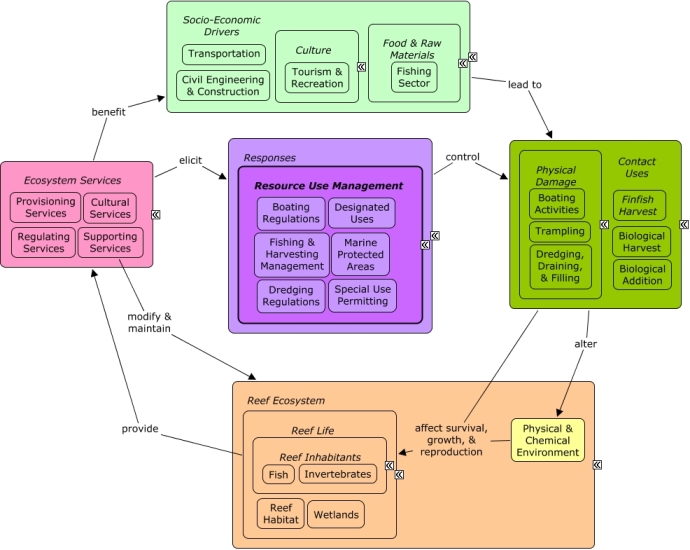
Dredging regulations are decisions or policies to control the location or intensity of physically damaging activities such as dredging, draining, or filling.
CMap
CMap Description
A change in the provision of ecosystem services, or a desire to improve provision of ecosystem services, may elicit responses to reduce or manage contact uses that cause physical damage to reef species. Dredging regulations can be implemented to control the location and intensity of dredging, draining, or filling activities. Many of the same socio-economic sectors that create pressures through contact uses benefit from goods and services provided by the reef, including recreational opportunities and seafood.Citations
| Citation | Year | Study Location | Study Type | Database Topics |
|---|---|---|---|---|
| Seas At Risk. 2009. Moving Towards Low Impact Fisheries In Europe Policy Hurdles & Actions. | 2009 | Southeast Asia; Europe | Review | Accidental & Illegal Harvest; Banks, Credit, & Securities; Climate; Dredging Regulations; Dredging, Draining, & Filling; Finfish Harvest; Fish; Fishing & Harvesting Management; Fishing Sector; Funding & Incentives; Special Use Permitting; Trawling & Fishing Gear Damage; Utility Line Construction & Maintenance |
| Gala, W. R., R. W. Hill, and L. A. Hostetter. 2008. Use of Habitat Equivalency Analysis (HEA) to determine the environmentally superior project alternative. Pages 1393-1401 in Society of Petroleum Engineers - 9th International Conference on Health, Safety and Environment in Oil and Gas Exploration and Production 2008 - \In Search of Sustainable Excellence\"". | 2008 | Artificial Habitat; Dredging Regulations; Dredging, Draining, & Filling; Fish; Oil & Gas Research & Exploration | ||
| Guest, J. R., P. A. Todd, E. Goh, B. Sivaloganathan, and K. P. Reddy. 2008. Can giant clam (Tridacna squamosa) populations be restored on Singapore's heavily impacted coral reefs? Aquatic Conservation: Marine and Freshwater Ecosystems 18:570-579. | 2008 | US Pacific & Hawaii | Aquaculture; Coastal Development; Dredging Regulations; Dredging, Draining, & Filling; Light; Sediment; Shipping, Storage, & Warehousing | |
| Price, A. R. G., M. J. Keeling, and I. N. Stewart. 2007. A robustness metric integrating spatial and temporal information: Application to coral reefs exposed to local and regional disturbances. Marine Ecology Progress Series 331:101-108. | 2007 | Global; Indian Ocean; India; Thailand | Index or Indicator | Climate; Dredging Regulations; Dredging, Draining, & Filling; Sea Temperatures; Special Use Permitting; Storms & Hurricanes; Water Depth & Sea Level |
| Reed, J. K., C. C. Koenig, and A. N. Shepard. 2007. Impacts of bottom trawling on a deep-water Oculina coral ecosystem off Florida. Bulletin of Marine Science 81:481-496. | 2007 | Florida | Commercial Fisheries; Dredging Regulations; Dredging, Draining, & Filling; Finfish Harvest; Fish; Lobster, Crab, & Shrimp; Piscivorous Fish; Recreational Fishing; Tourism & Recreation; Trawling & Fishing Gear Damage | |
| Office of Solid Waste and Emergency Response. 2005. Contaminated Sediment Remediation Guidance for Hazardous Waste Sites. EPA-540-R-05-012, US Environmental Protection Agency. | 2005 | India | Review; Field Study & Monitoring; Lab Study; Model | Biological Monitoring, Mapping, & Scientific Research; Dredging Regulations; Dredging, Draining, & Filling; Environmental Monitoring, Mapping, & Scientific Research; Finfish Harvest; Fish; Health Policies; Infrastructural Policies; Infrastructure; Landscape Conservation & Restoration; Remediation; Security Policies; Sediment; Shoreline Protection; Solid Waste Disposal; Surface & Groundwater Flow; Tourism & Recreation; Tourism & Recreation Policies; Waste Management Policies |
| Petit, C. C. and J. J. Vandenabeele. 2005. Supporting coastal and lake applications with the help of remote sensing. Pages 2771-2774 in International Geoscience and Remote Sensing Symposium (IGARSS). | 2005 | Indonesia | Field Study & Monitoring; Model; GIS & Maps; Remote Sensing; Decision Support Frameworks & Tools | Climate; Coastal Development; Dredging Regulations; Dredging, Draining, & Filling; Environmental Monitoring, Mapping, & Scientific Research; Finfish Harvest; Fish; Fishing Sector; Plankton; Sediment |
| Finkl, C. W. and R. H. Charlier. 2003. Sustainability of Subtropical Coastal Zones in Southeastern Florida: Challenges for Urbanized Coastal Environments Threatened by Development, Pollution, Water Supply, and Storm Hazards. Journal of Coastal Research 19:934-943. | 2003 | Florida; US East Coast (NC, SC, GA); Cuba | Model | Agriculture; Banks, Credit, & Securities; Chemical Use Regulations; Discharges; Dive, Snorkeling, & Swimming Tourism; Dredging Regulations; Dredging, Draining, & Filling; Fertilizer & Pesticide Use; Finfish Harvest; Landuse Management; Non-point Source Runoff; Nutrients; Remediation; Storms & Hurricanes; Surface & Groundwater Flow; Tourism & Recreation; Water; Wetlands |
| Reed, J. K. 2002. Deep-water Oculina coral reefs of Florida: Biology, impacts, and management. Hydrobiologia 471:43-55. | 2002 | Florida | Review | Anchoring & Vessel Grounding; Coastal Defense; Commercial Fisheries; Dredging Regulations; Dredging, Draining, & Filling; Finfish Harvest; Fish; Fishing Sector; Lobster, Crab, & Shrimp; Marine Protected Areas; Piscivorous Fish; Recreational Fishing; Skeletal Coral; Special Use Permitting; Tourism & Recreation; Trawling & Fishing Gear Damage |
| Maragos, J. E. 2000. Hawaiian Islands (U.S.A.). Seas at the millennium - an environmental evaluation - Volume 2 791-812. | 2000 | US Pacific & Hawaii | Field Study & Monitoring | Agriculture; Anchoring & Vessel Grounding; Apex Fish Predators; Aquaculture; Aquarium & Pet Trade; Aquarium Stock; Beaches & Nature Parks; Boating Activities; Boating Regulations; Dredging Regulations; Dredging, Draining, & Filling; Environmental Education & Outreach; Environmental Monitoring, Mapping, & Scientific Research; Finfish Harvest; Fish; Fishing Sector; Golf Course Operations; Hotel & Food Services; Invasive Species; Marine Birds; Marine Debris; Marine Protected Areas; Military; Pathogens; Recreational Fishing; Scientific Research; Sea Turtles; Sediment; Special Use Permitting; Storms & Hurricanes; Tourism & Recreation; Trawling & Fishing Gear Damage; Waterborne Discharges; Wetlands |
| Pugliese, R. 1998. Final habitat plan for the South Atlantic Region. South Atlantic Fishery Management Council, Charleston, SC. | 1998 | Florida; US East Coast (NC, SC, GA) | Field Study & Monitoring; Model | Accidental & Illegal Harvest; Agriculture; Aquaculture; Commercial Fisheries; Dredging Regulations; Dredging, Draining, & Filling; Finfish Harvest; Fishing Sector; Fleshy Macroalgae; Invertebrate Harvest; Lobster, Crab, & Shrimp; Mangroves; Monetary Valuation; Nutrients; Oil & Gas Research & Exploration; Piscivorous Fish; Recreational Fishing; Seagrasses; Special Use Permitting; Tourism & Recreation; Tourism & Recreation Policies; Trawling & Fishing Gear Damage |
| Collins, K. J., A. C. Jensen, A. P. M. Lockwood, and S. J. Lockwood. 1994. Coastal structures, waste materials and fishery enhancement. Bulletin of Marine Science 55:1240-1250. | 1994 | Review | Agriculture; Coal Mining; Coastal Defense; Dredging Regulations; Dredging, Draining, & Filling; Fishing Sector; Sediment; Shoreline Protection; Waste Management Policies | |
| Bode, LA NC E, LU CI AN O Mason, and TH OM AS Hardy. 1993. Application of numerical modelling to the prediction of dredge plume movement. Pages 379-384 in National Conference Publication - Institution of Engineers, Australia. | 1993 | Australia | Model | Dredging Regulations; Dredging, Draining, & Filling; Sediment |
| Stoddard, AN DR EW, RO GE R Wells, and KI M Devonald. 1985. Development And Application Of A Deepwater Ocean Waste Disposal Model For Dredged Material: Yabucoa Harbor, Puerto Rico. Marine Technology Society Journal 19:26-39. | 1985 | Puerto Rico | Model | Dredging Regulations; Dredging, Draining, & Filling; Sediment; Special Use Permitting |
| Campbell Thomas, J. and KI M Beachler. 1984. Engineering For Beach Restoration Dredging. Pages 1014-1023 in [No source information available]. | 1984 | Florida | Review | Beaches & Nature Parks; Dredging Regulations; Dredging, Draining, & Filling; Shoreline Protection; Special Use Permitting; Storms & Hurricanes; Tourism & Recreation |
| Schubert, C. and M. Laredo. 1984. Geology of Aves Island (Venezuela) and subsidence of Aves Ridge, Caribbean Sea. Marine Geology 59:305-318. | 1984 | South & Central America; Venezuela; Caribbean | GIS & Maps | Dredging Regulations; Dredging, Draining, & Filling; Sediment; Storms & Hurricanes; Water Depth & Sea Level |
| [No author name available]. 1977. Singapore dredge for Maldives. in [No source information available]. | 1977 | Maldives | Dredging Regulations; Dredging, Draining, & Filling |
Management Options
| Management Option | Description | Sources | Database Topics |
|---|---|---|---|
| Damage Assessment, Documentation & Response: Respond to Natural Resource Injuries from Vessel Groundings | This option involves assessing conditions and responding, as well as developing methodologies and protocols for coral dominated substrate, seagrass substrate, and mixed substrate. These protocols will help to determine how much damage has been done to the non-living coral framework. Ultimately, fine-tuning these protocols will allow for the most effective assessments. Evaluate these in light of current grounding regulations (#34). | NOAA Marine Sanctuary Program. 2007. Florida Keys National Marine Sanctuary revised management plan. National Ocean Service, Key West, FL. Collier, C., Dodge, R., Gilliiam, Gracie, K., Gregg, L., Jaap, W., Mastry, M., and Poulos, N. 2007. Rapid Response and Restoration for coral reef injuries in the southeest Florida. Southeast Florida Coral Reef Initiative. |
Anchoring & Vessel Grounding; Boating Activities; Collaboration & Partnering; Contact Uses; Coral; Cultural Policies; Dredging Regulations; Ecosystem Monitoring & Restoration; Environmental Monitoring & Restoration; Environmental Monitoring, Mapping, & Scientific Research; Physical Damage; Reef Habitat; Reef Life; Resource Use Management; Seagrasses; Security & Public Administration Policies; Stony Coral; Wetlands |
| Damage Assessment, Documentation & Response: Respond to Natural Resource Injuries from Natural Physical Disturbance | There are currently no standardized or uniform protocols to follow after natural or catastrophic events (such as hurricanes). Such protocols need to be developed in order to respond to specific issues that follow catastrophic natural events. | NOAA Marine Sanctuary Program. 2007. Florida Keys National Marine Sanctuary revised management plan. National Ocean Service, Key West, FL. |
Biological Monitoring & Restoration; Biological Monitoring, Mapping, & Scientific Research; Climate; Dredging Regulations; Ecosystem Monitoring & Restoration; Environmental Monitoring & Restoration; Environmental Monitoring, Mapping, & Scientific Research; Physical & Chemical Environment; Physical Damage; Physical Variables; Resource Use Management; Special Use Permitting; Storms & Hurricanes; Wetland & Reef Restoration |
| Damage Assessment, Documentation & Response: Respond to Natural Resource Injuries from Coastal Construction & Development | This involves assessing coral, seagrass, and hard bottom substrate that is impacted during coastal construction repair or alternation. If unacceptable damages are occurring this information will be useful in future permit decision making. If infringements have occurred, this information may be useful for compensatory mitigation and liability for restoration of those natural resources injured. | NOAA Marine Sanctuary Program. 2007. Florida Keys National Marine Sanctuary revised management plan. National Ocean Service, Key West, FL. |
Biological Monitoring & Restoration; Civil Engineering & Construction; Coastal Development; Coastal Engineering; Construction Codes & Projects; Docks & Marinas; Dredging Regulations; Dredging, Draining, & Filling; Ecosystem Monitoring & Restoration; Environmental Monitoring & Restoration; Impervious Surfaces; Infrastructural Policies; Infrastructure; Land-Based Civil Engineering; Landscape Changes; Mangroves; Mitigation; Permitting & Zoning; Physical Damage; Physical Variables; Ports & Harbors; Reef Habitat; Remediation; Resource Use Management; Seagrasses; Shoreline Armoring; Special Use Permitting; Utilities; Utility Line Construction & Maintenance; Wetland & Reef Restoration; Wetlands |
| Damage Assessment, Documentation & Response: Operating Permits for Towing & Salvage Professionals | This management option evaluates the need for a permitting system for all towing and salvage operations. This type of permit would require salvage operators to notify injury response when there are groundings. The permit program would also reduce impacts by ensuring operators know the proper practices and use the proper equipment to most effectively minimize damage to the operating area. | NOAA Marine Sanctuary Program. 2007. Florida Keys National Marine Sanctuary revised management plan. National Ocean Service, Key West, FL. |
Anchoring & Vessel Grounding; Boat Movement; Boating Activities; Boating Regulations; Contact Uses; Dredging Regulations; Physical Damage; Resource Use Management; Special Use Permitting; Water Transportation |
| Damage Assessment, Documentation & Response: Monitor & Respond to Damages From Fishing Gear | When a habitat is damaged or an injury occurs to natural resources as a result of fishing gear, it is beneficial to respond and assess. Responding appropriately is likely to involve other management options such as #91 if the injury was due to a violation. It is important to assess the damage and gather information as to why the injury occurred, so as to be able to find alternative fishing gear or practices that are less likely to cause such damages, for research such as #42. There should be protocols and methodologies for collecting damage assessment data to ensure it can be added to information systems such as #76 to track recovery, especially if repairing or restorative actions are taken. Standardized methods are also important when sharing this information with state and federal fisheries management (#64). | NOAA Marine Sanctuary Program. 2007. Florida Keys National Marine Sanctuary revised management plan. National Ocean Service, Key West, FL. |
Artisanal Fishing; Boating Activities; Commercial Fisheries; Contact Uses; Dredging Regulations; Fishing & Harvesting Management; Physical Damage; Recreational Fishing; Resource Use Management; Trawling & Fishing Gear Damage |
| Data Management & Decision Tools: Develop and Maintain Vessel Grounding Database | This management approach would involve refining and maintaining a vessel grounding database and adequate staffing for on-going management, GIS processing of archived data, creating products for management case tracking, and developing a database that is user-friendly and useful. If previously established, the management option #165, will allow this data to be combined with similar data from other inventory management options such as #95, and future integration into larger databases, such as that in the management option #85. | NOAA Marine Sanctuary Program. 2007. Florida Keys National Marine Sanctuary revised management plan. National Ocean Service, Key West, FL. |
Anchoring & Vessel Grounding; Boating Activities; Boating Regulations; Contact Uses; Decision Support; Designated Uses; Dredging Regulations; Environmental Monitoring, Mapping, & Scientific Research; Physical Damage; Pressures; Resource Use Management; Responses; Security & Public Administration Policies; Transportation Policies |
| Enforcement: Enforce Statues, Regulation and Permit Requirements | This option ensures compliance with statues, regulations, and permit requirements. This is accomplished through intensive on-site patrols by authorized law enforcement officers. Agencies at the state level as well as NOAA can assist with enforcement. For success, it is important that law enforcement be trained in the compliance requirements of other agencies (e.g. Marine Heritage Resource (MHR) permitting compliance). A standardized training program to help better ensure cross- deputization of enforcement agencies would be necessary. | NOAA Marine Sanctuary Program. 2007. Florida Keys National Marine Sanctuary revised management plan. National Ocean Service, Key West, FL. |
Boating Regulations; Collaboration & Partnering; Cultural Protections; Dredging Regulations; Fisheries & Hunting Policies; Fishing & Harvesting Management; Permitting & Zoning; Resource Use Management; Security & Public Administration Policies; Special Use Permitting |
| Implementing Notification and Response Protocols: Coordinate with Other Management and Enforcement Agencies to Develop Standardized Vessel Grounding and Spill-Response Protocols | This plan aims to coordinate with other management and enforcement agencies to create uniform spill response and vessel grounding protocols. | NOAA Marine Sanctuary Program. 2007. Florida Keys National Marine Sanctuary revised management plan. National Ocean Service, Key West, FL. |
Anchoring & Vessel Grounding; Boating Activities; Collaboration & Partnering; Contact Uses; Cultural Policies; Dredging Regulations; Energy Policy & Development; Food & Energy Policies; Physical Damage; Pressures; Resource Use Management; Responses; Security & Public Administration Policies |
| Injury Prevention: Assist Waterway Marking/Management | This management options involves reporting incidents to identify �hotspots� of seagrass and coral that have been negatively impacted by vessel groundings. This can be achieved through properly marking waterways develop regional patterns for vessel groundings. | NOAA Marine Sanctuary Program. 2007. Florida Keys National Marine Sanctuary revised management plan. National Ocean Service, Key West, FL. |
Anchoring & Vessel Grounding; Boating Activities; Contact Uses; Dredging Regulations; Physical Damage; Pressures; Resource Use Management; Responses |
| Injury Prevention: Minimize or Eliminate Impact from , Derelict or Sunken Vessels | This option intends to reduce the effects of vessel impacts through creating mooring fields, pump-out stations, and providing support for removing derelict vessels. Actions such as these are important for reducing contact and waste impacts from live-aboard vessels. Also, the removal of intrusive vessels will help contribute to the restoration of reef areas to previous conditions. | NOAA Marine Sanctuary Program. 2007. Florida Keys National Marine Sanctuary revised management plan. National Ocean Service, Key West, FL. |
Anchoring & Vessel Grounding; Biological Monitoring & Restoration; Boating Activities; Contact Uses; Dredging Regulations; Ecosystem Monitoring & Restoration; Health Policies; Infrastructural Policies; Physical Damage; Pressures; Resource Use Management; Responses; Transportation Policies; Waste Management Policies; Wetland & Reef Restoration |
| Injury Prevention: Assist Education and Outreach | This plan is to help prevent groundings. This can be achieved through providing products and information such as statistics, avoidance techniques, and legal/financial consequences. Such information would be provided for media, interest groups, periodicals, publications, and environmental organizations. | NOAA Marine Sanctuary Program. 2007. Florida Keys National Marine Sanctuary revised management plan. National Ocean Service, Key West, FL. |
Anchoring & Vessel Grounding; Boating Activities; Broadcasting, Publishing, & Libraries; Contact Uses; Cultural Policies; Culture; Dredging Regulations; Ecosystem Monitoring & Restoration; Education & Information; Environmental Education & Outreach; Environmental Monitoring & Restoration; Physical Damage; Pressures; Resource Use Management; Responses; Sectors Filling Human Needs; Socio-Economic Drivers |
| Marine Zoning: Sanctuary Preservation Areas (SPAs) | This is a type of Marine Zoning used by the Florida Keys National Marine Sanctuary (FKNMS). SPAs focus on the protection of shallow, heavily used reefs where conflicts occur between user groups, and where concentrated visitor activity leads to resource degradation. They are designed to enhance the reproductive capabilities of renewable resources, protect areas critical for sustaining and protecting important marine species, and reduce user conflicts in high-use areas. This is accomplished through a prohibition of consumptive activities within these areas. They have been chosen based on the status of important habitat, the ability of a particular area to sustain and protect the habitat, the level of visitor use, and the degree of conflict between consumptive and non-consumptive users. The actual size and location of these zones have been determined by examination of user patterns, aerial photography, and ground-truthing of specific habitats. | NOAA Marine Sanctuary Program. 2007. Florida Keys National Marine Sanctuary revised management plan. National Ocean Service, Key West, FL. |
Accidental & Illegal Harvest; Anchoring & Vessel Grounding; Aquaculture; Aquarium & Pet Trade; Aquarium Stock; Artisanal Fishing; Beaches & Nature Parks; Biological Addition; Biological Harvest; Biological Monitoring & Restoration; Boat Movement; Boating Activities; Boating Regulations; Coastal Defense; Coastal Development; Coastal Engineering; Commercial Fisheries; Commercial Fishing Boats; Complex Habitat & Resources; Cruise Ships; Cultural Services; Decision Support; Designated Uses; Dive, Snorkeling, & Swimming Tourism; Dredging Regulations; Dredging, Draining, & Filling; Ecosystem Monitoring & Restoration; Educational & Research Opportunities; Entertainment & Accommodation Services; Environmental Monitoring & Restoration; Finfish & Shellfish Stock; Finfish Harvest; Fisheries & Hunting Policies; Fishing & Harvesting Management; Fishing Sector; Invertebrate Harvest; Landscape Changes; Large Ships; Live Collection; Marine Protected Areas; Oil & Gas Tankers; Ornamental Jewelry & Art; Permitting & Zoning; Physical Damage; Public Administration; Recreational Fishing; Recreational Opportunities; Resource Use Management; Security; Small Boats; Souvenir & Decorative Trade; Supporting Services; Tourism & Recreation; Tourism & Recreation Policies; Trampling; Travel Services & Tour Operators; Trawling & Fishing Gear Damage; Water Resources; Water Transportation |
| Marine Zoning: Ecological Reserves (ERs) | Ecological Reserves set aside areas with minimal human interference. These reserves aim to enhance and protect biodiversity through encompassing large, contiguous habitats. The goal of ecological reserves is to encourage spawning, nurseries, and residence areas that contribute to genetic protection of fish and marine life. Ecological Reserves can be achieved through a variety of methods such as: placing/maintaining buoys along zone boundaries; adjusting boundaries if necessary; evaluating allowable activities within zone boundaries; identifying potential areas that need additional zoning; reviewing the effectiveness of the zoning; and revising NOAA and GIS charts. | NOAA Marine Sanctuary Program. 2007. Florida Keys National Marine Sanctuary revised management plan. National Ocean Service, Key West, FL. |
Biochemical & Genetic Resources; Biological Addition; Biological Harvest; Biological Monitoring & Restoration; Boating Activities; Boating Regulations; Coastal Defense; Commercial Fishing Boats; Complex Habitat & Resources; Cruise Ships; Decision Support; Designated Uses; Dredging Regulations; Dredging, Draining, & Filling; Ecosystem Monitoring & Restoration; Environmental Monitoring & Restoration; Finfish Harvest; Fisheries & Hunting Policies; Fishing & Harvesting Management; Fishing Sector; Invertebrate Harvest; Large Ships; Live Collection; Marine Protected Areas; Oil & Gas Tankers; Permitting & Zoning; Physical Damage; Provisioning Services; Resource Use Management; Security Policies; Small Boats; Tourism & Recreation; Trampling; Water Transportation |
| Regulatory Review and Development: Evaluate Vessel Grounding Regulations | In many areas, there are already regulations that target prop scarring to seagrasses and the seabed. Current boat grounding regulations should be evaluated to determine if additional regulations would be beneficial. | NOAA Marine Sanctuary Program. 2007. Florida Keys National Marine Sanctuary revised management plan. National Ocean Service, Key West, FL. |
Anchoring & Vessel Grounding; Boating Activities; Boating Regulations; Coastal Development; Contact Uses; Cruise Ships; Cultural Services; Culture; Decision Support; Docks & Marinas; Dredging Regulations; Physical Damage; Ports & Harbors; Recreational Fishing; Recreational Opportunities; Resource Use Management; Seagrasses; Security & Public Administration Policies; Security Policies; Small Boats; Tourism & Recreation; Transportation; Water Resources; Water Transportation; Wetlands |
| Regulatory Review and Development: Change Salvaging & Towing Practices | This option seeks to protect natural resources and reduce damage resulting from improper vessel salvage methods. In the past, salvage techniques have caused collateral damage when removing vessels grounded on the reef. These injuries often occur in the immediate area surrounding the grounded vessel but can be avoided with the use of proper salvage techniques developed with reef resources in mind. The principal causes of collateral injuries are dragging a vessel off the reef instead of floating it off; the use of steel towing cables that can drop on or drag across the substrate, impacting and dislodging resources (reef structure, corals, and sponges); and propwash and surge, generated by tugboat propellers, that displace sediment and dislodge organisms. To avoid or minimize collateral injuries, a reconnaissance survey should be conducted while the vessel is grounded to evaluate reef resources in the immediate area surrounding the vessel and determine an appropriate extraction route. Bunker fuel and cargo may need to be offloaded. Floating or buoyed towlines should be used instead of steel cables, and towing activities should be conducted at or near high tide to facilitate floating the vessel. Before and during the extraction, global positioning system (GPS) coordinates at the bow and stern of the vessel should be recorded to assist with future injury assessment. GPS tracking should be operating on the grounded vessel during egress from the site and on all salvage vessels or tugboats involved with the salvage operation. The outbound path for vessel extraction may also need to be buoyed, to help avoid or identify injuries that may occur during the salvage operation. | NOAA Marine Sanctuary Program. 2007. Florida Keys National Marine Sanctuary revised management plan. National Ocean Service, Key West, FL. |
Anchoring & Vessel Grounding; Boat Movement; Boating Activities; Boating Regulations; Coastal Engineering; Collaboration & Partnering; Contact Uses; Decision Support; Dredging Regulations; Dredging, Draining, & Filling; Environmental Education & Outreach; Improved Technology; Infrastructural Policies; Physical Damage; Resource Use Management; Security & Public Administration Policies; Trampling; Transportation; Transportation Policies; Water Transportation |
| Regulatory Review and Development: Evaluate Artificial Reef Regulations | Discharge/depositing of materials and constructions on the seabed are both prohibited without permits, regulating the construction of new artificial reefs. Likewise, existing artificial reefs are protected through permit requirements for any alternation of the seabed. There are still further considerations for protecting artificial reefs. Artificial reef materials and construction choices are very important and may change based on the specific location and desired impacts. An artificial reef to attract recreational fishing differs from one for recreational divers or shoreline storm protection. Many artificial reefs were formally large ships, oil rigs or other types of waste that have been decommissioned and would be too large and expensive to dismantle on land. In these cases it is important to put restrictions on the sinking process to ensure there won�t be any type of chemical leakage and that the structure is stable on the seabed. (#189) (#190) | National Oceanic and Atmospheric Administration. 2007. National Artificial Reef Plan: Guidelines for Siting, Construction, Development, and Assessment of Artificial Reefs. US Department of Commerce. NOAA Marine Sanctuary Program. 2007. Florida Keys National Marine Sanctuary revised management plan. National Ocean Service, Key West, FL. |
Artificial Habitat; Coastal Defense; Contact Uses; Discharge Limitations; Discharges; Dive, Snorkeling, & Swimming Tourism; Dredging Regulations; Environmental Monitoring & Restoration; Large Ships; Oil & Gas Industry; Permitting & Zoning; Physical Damage; Recreational Fishing; Solid Waste Disposal; Special Use Permitting; Tourism & Recreation; Waste Management; Waterborne Discharges |
| Regulatory Review and Development: Evaluate Channel & Reef Navigation Markers | This option would evaluate the need for proper marking to ensure better navigation. There are many types of markers, including buoys, charts, beacons, and GPS mapping. Such markers can also be used to advocate prohibition on vessel speeds greater than idle speed in areas designated as idle-speed only/no-wake and around shallow reef locations. | NOAA Marine Sanctuary Program. 2007. Florida Keys National Marine Sanctuary revised management plan. National Ocean Service, Key West, FL. |
Anchoring & Vessel Grounding; Beach & Land Formation; Boat Movement; Boating Activities; Boating Regulations; Coastal Development; Contact Uses; Cultural Services; Culture; Decision Support; Designated Uses; Dive, Snorkeling, & Swimming Tourism; Dredging Regulations; Permitting & Zoning; Physical Damage; Provisioning Services; Public Administration; Recreational Fishing; Recreational Opportunities; Security & Public Administration Policies; Small Boats; Tourism & Recreation; Trampling; Transportation Policies; Water Depth & Sea Level; Water Resources; Water Transportation |
| Regulatory Review and Development: Evaluate Coral Touching Regulations | Currently touching, removing, damaging, distributing, and injuring any living or dead coral or coral formation is prohibited in Sanctuary Preservation Areas and Ecological Reserves. An investigation will be conducted to consider extending this prohibition to high-use, sensitive and vulnerable areas. | NOAA Marine Sanctuary Program. 2007. Florida Keys National Marine Sanctuary revised management plan. National Ocean Service, Key West, FL. |
Beaches & Nature Parks; Contact Uses; Coral; Decision Support; Dredging Regulations; Physical Damage; Skeletal Coral; Stony Coral; Tourism & Recreation; Tourism & Recreation Policies; Trampling |
| Regulatory Review and Development: Evaluate Dredging Regulations | Dredging is oftentimes prohibited with certain exceptions. Dredging regulation often falls under other controls over the alteration of the seabed, discharging or depositing materials. At times dredging is necessary for navigation or other activities, necessitating .permitting mechanisms for allowing otherwise prohibited activities. Revising the regulations to help eliminate negative dredge-and-fill activities within a certain distance of corals would be beneficial because it would help promote the reestablishment of sensitive benthic communities. Reservoirs may require periodic dredging to remove sediment that may have collected. | NOAA Marine Sanctuary Program. 2007. Florida Keys National Marine Sanctuary revised management plan. National Ocean Service, Key West, FL. |
Beach & Land Formation; Beaches & Nature Parks; Biological Monitoring & Restoration; Coastal Engineering; Construction Codes & Projects; Dam Construction & Maintenance; Decision Support; Discharge Limitations; Docks & Marinas; Dredging Regulations; Dredging, Draining, & Filling; Ecosystem Monitoring & Restoration; Hydrologic Management; Mining; Mining Policies; Physical Damage; Point Source Discharges; Ports & Harbors; Provisioning Services; Resource Use Management; Sand & Rock Production; Security & Public Administration Policies; Special Use Permitting; Substrate; Transportation; Utility Line Construction & Maintenance; Water Transportation |
| Resource Use Management: Marine Heritage Resource Protections | This management option involves protecting underwater items/sites that have historical, cultural, archaeological, or paleontological significance. This response advocates permits for action that may degrade the resource. This can be accomplished through creating an MHR field unit, monitoring MHR site degradation, and evaluating excavation and mitigation techniques. Field units can help conduct field research and coordinated, permitted research activities. Experts relating to archaeological research underwater can also be hired with additional funding. Through evaluation of excavation techniques, new technologies can be suggested such as: turbidity screens, sediment removal equipment, and seagrass restoration/relocation protocols to lead to less disturbance. Inventory and decision tools can also be used in the aid of Maritime Heritage Resource protection. | NOAA Marine Sanctuary Program. 2007. Florida Keys National Marine Sanctuary revised management plan. National Ocean Service, Key West, FL. |
Civil Engineering & Construction; Construction Codes & Projects; Cultural Policies; Cultural Protections; Cultural Services; Decision Support; Designated Uses; Dredging Regulations; Dredging, Draining, & Filling; Ecosystem Services; Educational & Research Opportunities; Existence Value & Sense of Place; Mitigation; Physical Damage; Pipelines; Reef Life; Resource Use Management; Seagrasses; Security & Public Administration Policies; Special Use Permitting; Tourism & Recreation Policies; Utility Line Construction & Maintenance; Valuation; Wetlands |
| Restoration: Restore injured or destroyed coral reef framework | This approach would allow to use funds from case settlements to reconstruct/replace coral framework that has been compromised. This approach aids to restore the coral�s structural and ecological functionality, as well as reestablish aesthetic qualities associated with corals. | NOAA Marine Sanctuary Program. 2007. Florida Keys National Marine Sanctuary revised management plan. National Ocean Service, Key West, FL. |
Biological Monitoring & Restoration; Coral; Dredging Regulations; Ecosystem Monitoring & Restoration; Funding & Incentives; Reef Habitat; Reef Life; Resource Use Management; Responses; Security & Public Administration Policies; Wetland & Reef Restoration |
| Restoration: Restore Reef Habitat and Salvage Benthic Inhabitants Injured by Physical Damage | This management approach involves salvaging, maintenance, and re-stabilization or injured resources by management staff and private contractors in order to rescue and provide first aid following physical damage such as vessel groundings. This can be achieved using Reef Medics and other volunteer programs because these groups have experience with vessel navigation and operation, snorkeling, and SCUBA diving. Also, it allows for researchers to collect living coral material when relocation of such organisms is not possible. Salvage and re-stabilization is not limited to the living coral; octocorals, seagrasses, and the non-living framework may all be damaged of destabilized from groundings or other physical impacts. In addition to the habitat's structural integrity, it is important to re-establish aesthetics and ecological functionality. Funds from mitigation and case settlements should be used for this work, as long term costs of restoration and monitoring can be extensive. | NOAA Marine Sanctuary Program. 2007. Florida Keys National Marine Sanctuary revised management plan. National Ocean Service, Key West, FL. Collier, C., Dodge, R., Gilliiam, Gracie, K., Gregg, L., Jaap, W., Mastry, M., and Poulos, N. 2007. Rapid Response and Restoration for coral reef injuries in the southeest Florida. Southeast Florida Coral Reef Initiative. |
Anchoring & Vessel Grounding; Biological Monitoring & Restoration; Biological Monitoring, Mapping, & Scientific Research; Boating Activities; Coastal Engineering; Collaboration & Partnering; Contact Uses; Coral; Cultural Policies; Cultural Services; Culture; Dredging Regulations; Dredging, Draining, & Filling; Ecosystem Monitoring & Restoration; Educational & Research Opportunities; Octocoral; Physical Damage; Reef Habitat; Reef Life; Resource Use Management; Seagrasses; Security & Public Administration Policies; Skeletal Coral; Stony Coral; Trawling & Fishing Gear Damage; Water Transportation; Wetland & Reef Restoration; Wetlands |
| Waterway Management: Waterway Management/Marking Plan | Proper waterway markings provide coherent guidance for boats. Clearly-marked waterway exits and entrances reduce the probability of damage to reefs from boat gear damage, boat movement, trampling, and ballast discharge. Waterway marking can be achieved through surveying damage from propeller scarring and vessel groundings, enhancing channel marking aids, assessing the effectiveness of channel marking, and through removing waterway obstructions. "Hotspots" where many incidents have been reported should be considered for further marking, especially those that are in high use areas. | NOAA Marine Sanctuary Program. 2007. Florida Keys National Marine Sanctuary revised management plan. National Ocean Service, Key West, FL. |
Anchoring & Vessel Grounding; Boat Movement; Boating Activities; Boating Regulations; Contact Uses; Decision Support; Dredging Regulations; Dredging, Draining, & Filling; Physical Damage; Resource Use Management; Trampling; Trawling & Fishing Gear Damage; Water; Water Transportation |
Laws
| Legal Citation | Purpose of Law | Management Organization | Database Topics |
|---|---|---|---|
| 25-Year Permits for Maintenance Dredging in Deepwater Ports; Deepwater Ports Maintenance Dredging and Disposal Manual, 62-045 Florida Administrative Code. | 62-45.001 Authority, Intent and Policy.
(1) This chapter is promulgated under the authority of Sections 403.061(26) and 403.816(1), F.S.
(2) It is the intent of this chapter to establish a permitting system for maintenance dredging in deep water commercial navigation
areas of the ports listed in Rule 62-45.020, F.A.C. This chapter incorporates standards and criteria which recognize the present most
beneficial use of these waters for deep water commercial navigation. Since the implementation of a comprehensive maintenance
dredging management plan is a major factor in determining the adequacy of a long-term maintenance dredging program, it is the
further intent of this chapter to give a position of prominence to such a plan within this permit system.
(3) It is the policy of the Department to provide a regulatory process which will enable the ports to conduct maintenance
dredging in an environmentally sound, expeditious and efficient manner.62-45.020 Scope.
(1) The permit system established by this chapter applies only to the ports of Ft. Pierce, Jacksonville, Miami, Palm Beach,
Panama City, Pensacola, Port Canaveral, Port Everglades, Port Manatee, Port St. Joe, St. Petersburg, and Tampa.
(2) The activities which may be included within a permit issued under this chapter are limited to maintenance dredging and
disposal of the maintenance dredged material.
(3) Applicants for permits under this chapter are limited to the port authorities or private interests using the port for deep water
commercial shipping and the U.S. Army Corps of Engineers. The Department shall not issue separate permits to the port authority or
private interests and the U. S. Army Corps of Engineers when the responsibility of maintenance dredging or the disposal of the
maintenance dredged material from the port is shared by any of the parties. The permit, if issued, shall clearly specify the duties and
responsibilities of each party.
(4) A permit may be issued for any length of time up to 25 years. There shall be no more than one such permit for each of the
ports listed in subsection (1).
(5) The area within which work under this permit system may take place is limited to the federally maintained, port authority
maintained, or private interest maintained navigation channels, turning basins, or harbor berths associated with deep water
commercial navigation and associated dredged material disposal sites. Eligible port maintenance dredging areas are depicted on
NOS Charts Nos. 11491 (Port of Jacksonville), 11478 (Port Canaveral), 11475 (Fort Pierce Harbor), 11466 (Port of Palm Beach),
11468 (Port of Miami), 11470 (Port Everglades), 11413 (Tampa Bay, Northern Part), 11414 (Tampa Bay, Southern Part), 11393
(Port St. Joe), 11391 (Panama City), and 11383 (Port of Pensacola) on file with the Department and adopted here by reference.
Copies are available at cost upon request from the Office of Beaches and Coastal Systems, 3900 Commonwealth Boulevard, MS
300, Tallahassee, Florida 32399-3000. Application to Coral Reefs:Proper, environmentally sound, dredging and disposal of dredged material, as reviewed by permit processers, will limit the amount of sediment and nutrients released to open water. The process will be particularly applicable to coral reefs for the dredging and disposal of Miiami harbor. Legislative Actions: Comments: |
Florida State Department of Environmental Protection Jurisdiction: US State Waters |
Dredging Regulations; Dredging, Draining, & Filling; Large Ships; Nutrients; Oil & Gas Tankers; Ports & Harbors; Resource Use Management; Sediment |
| Biscayne Bay Aquatic Preserve, 18-18 Florida Administrative Code. | 18-18.001 Intent.
(1) The Biscayne Bay Aquatic Preserve, the boundaries of which are fully described in Rule 18-18.002, F.A.C., was established for the purpose of preserving and enhancing Biscayne Bay and all natural waterways tidally connected to the bay in an essentially natural condition so that its biological and aesthetic values may endure for the enjoyment of future generations.
(2) These rules shall apply to all lands public and private within the boundaries of the preserve. However, privately owned uplands shall be excluded from these rules except as otherwise provided for herein.
(3) In promulgating and implementing these rules, it is the intent of the Department to construe the provisions of Sections 258.397 and 258.35 through 258.46, F.S., together and to apply the more stringent statutory provisions for the maintenance of the preserve.
(4) The preserve shall be administered and managed in accordance with the following goals:
(a) To preserve, protect, and enhance Biscayne Bay and all natural waterways tidally connected to the bay by reasonable regulation of human activity within the preserve through the development and implementation of a comprehensive management program;
(b) To protect and enhance the waters of the preserve so that the public may continue to enjoy the traditional recreational uses of those waters such as swimming, boating and fishing;
(c) To coordinate with federal, state, and local agencies to aid in carrying out the intent of the legislature in creating the preserve;
(d) To use applicable federal, state, and local management programs, which are compatible with the intent and provisions of the Act and these rules, to assist in managing the preserve;
(e) To encourage activities that protect or enhance the biological and aesthetic values of the preserve, including but not limited to the modification of existing manmade conditions towards their natural condition, when reviewing applications or developing and implementing management plans for the preserve;
(f) To preserve and promote indigenous life forms and habitats including but not limited to sponges, soft corals, hard corals, seagrasses, mangroves, mud flats, marine reptiles, game and non-game fish species, marine mammals, tropical marine invertebrates, birds and shellfish;
(g) To acquire additional title interests in land wherever such acquisitions would serve to protect or enhance the biological or aesthetic values of the preserve. Application to Coral Reefs:Biscayne Bay Aquatic Preserve protection of water quality will contribute to a lowering of contaminants leaving the preserve on tides and thus limiting the contaminants that reach off-shore ecosystems including the FKNMS and the reef system within the sanctuary. Legislative Actions: Comments:This chapter establishes the rules to protect the Biscayne Bay Aquatic Preserve, which was established for the purpose of preserving and enhancing Biscayne Bay and all natural waterways tidally connected to the bay in an essentially natural condition so that its biological and aesthetic values may endure for the enjoyment of future generations. |
Florida State Department of Environmental Protection Jurisdiction: Designated Marine Areas |
Accidental & Illegal Harvest; Anchoring & Vessel Grounding; Ballast Discharge; Boat Movement; Coastal Development; Docks & Marinas; Dredging Regulations; Dredging, Draining, & Filling; Environmental Education & Outreach; Existence Value & Sense of Place; Finfish & Shellfish Stock; Finfish Harvest; Hydrologic Management; Landuse Management; Mangroves; Marine Birds; Marine Debris; Nutrients; Point Source Discharges; Recreational Opportunities; Resource Use Management; Seagrasses; Seawater Flow; Sediment; Sewage Treatment; Small Boats; Waste Management Policies; Wastewater Discharge |
| Chapter 21: Virgin Islands coastal zone management, 12 Virgin Islands Code. | Protect, maintain, preserve and, where feasible, enhance and restore, the overall quality of the environment in the coastal zone, the natural and man-made resources therein, and the scenic and historic resources of the coastal zone for he benefit of residents of and visitors of the USVI Application to Coral Reefs:The Legislature stated coastal zone protection will conserve ecologically significant resource areas for their contribution to marine productivity and value as wildlife habitats, and preserve the function and integrity of reefs, marine meadows, salt ponds, mangroves and other significant natural areas. The legislation will also maintain or increase coastal water quality through control of erosion, sedimentation, runoff, siltation and sewage discharge. Legislative Actions:Any violation of the chapter will be grounds for revocation or suspension of coastal zone permit and an order to cease and desist. Any person who violates any provision of the chapter shall be subject to a civil fine not to exceed $10,000 per day. Exemplary damages may be assessed at the discretion of the court. Comments:Section 908 of the law shows Coastal Zone Boundaries. Section 909 shows areas of special concern. |
US Virgin Islands, Department of Planning and Natural Resources, Division of Environmental Protection Jurisdiction: US Virgin Islands |
Coastal Development; Coastal Engineering; Construction Codes & Projects; Dredging Regulations; Mangroves; Marine Protected Areas; Resource Use Management; Seagrasses; Shoreline Armoring |
| Chapter 3: Trees and vegetation next to waterways, 12 Virgin Islands Code. | Establishes buffer zone for protecting natural watercourses from vegetation clearing. The buffer zone either 30 feet from the center of the natural watercourse, or 25 feet from its edge, whichever is greater. Application to Coral Reefs:Assists in erosion control and can protect reefs from harmful sedimentation, if the stream or river sediment is capable of reaching the coral reef. Vegetation along river and stream banks will remove nutrients and assist in preventing eutrophocation of waters that can reach coral reefs. Legislative Actions:Enforcement is by conservation officers with assistance from local police when required. Penalties are fines of not more than $100, or 180 days in jail, or both Comments:Permits can be obtained if the purpose of clearing is for development. |
US Virgin Islands, Department of Planning and Natural Resources, Division of Environmental Protection Jurisdiction: US Virgin Islands |
Building & Home Construction; Coastal Development; Construction Codes & Projects; Ditching & Soil Disturbance; Dredging Regulations; Dredging, Draining, & Filling; Existence Value & Sense of Place; Landscape Conservation & Restoration; Landscaping & Household Services; Landuse Management; Resource Use Management; Shoreline Protection; Wetlands |
| Delineation of the landward extent of wetlands and surface waters, 62-340 Florida Administrative Code Annotated (2000). | The Rule's intent is to provide a unified statewide methodology for the delineation of the extent of wetlands to satisfy the mandate of Section 373.421, F. S. Application to Coral Reefs:Preservation of wetlands will allow them to continue to function as buffers for sediment and contaminant control keeping them from reaching estuarine and marine waters and eventually habitats including coral reefs. Legislative Actions:The Rule is administrative and methodological for delineation purposes. Comments: |
Florida Department of Environmental Protection Jurisdiction: State Coastal Waters; US State Waters; Designated Marine Areas |
Agriculture, Aquaculture, & Forestry Policies; Coastal Development; Dam Construction & Maintenance; Docks & Marinas; Dredging Regulations; Drinking Water Supply; Energy Policy & Development; Finfish & Shellfish Stock; Fish; Invertebrates; Landuse Management; Molluscs; Pipelines; Ports & Harbors; Road Construction & Maintenance; Sediment; Sewage Treatment; Shoreline Armoring; Small Boats; Solid Waste Disposal; Utility Line Construction & Maintenance; Wetlands |
| Dredge and Fill Activities, 62-312 Florida Administrative Code. | This part provides the requirements and procedures for obtaining permits and jurisdictional declaratory statements from the Department pursuant to Sections 403.91 through 403.929, F.S. Dredging or filling which is grandfathered by subsections 403.913(6), (8) and (9), F.S., is governed by Rules 62-312.150 and 62-312.160, F.A.C. The requirements of this part are in addition to and not in lieu of the water quality standards which are required by other portions of these sections. Except for the definitions contained in Rule 62-312.020, F.A.C., which shall also apply to activities regulated under Part IV of Chapter 373, F.S., the provisions of this Part shall only apply to activities in the geographical territory of the Northwest Florida Water Management District and to activities grandfathered under Sections 373.414(9), (11), (12)(a), (13), (14), (15) and (16), F.S.
Specific Authority 373.414(11)-(16), 373.4145, 403.805(1) FS. Law Implemented 373.409, 373.413, 373.414(9), (11), (12)(a), (13), (14), (15), (16), 373.4145, 373.416, 373.418, 403.061, 403.813, 403.814 FS. History�New 12-10-84, Amended 8-7-85, Formerly 17-12.010, 17-312.010, Amended 10-3-95. Application to Coral Reefs:The permit reviewers will require BMP for dredge and fill activities. This will include siltation reduction methods that will keep sediment, nutrient and other contaminants from leaving the work site and getting into the water column and potentially reaching sensitive ecosysten, including coral reefs. Legislative Actions: Comments:This part provides the requirements and procedures for obtaining permits and jurisdictional declaratory statements from the Department for dredge and fill activities. |
Florida State Department of Environmental Protection Jurisdiction: State Coastal Waters; US State Waters |
Complex Habitat & Resources; Cruise Ships; Dredging Regulations; Dredging, Draining, & Filling; Large Ships; Nutrients; Oil & Gas Tankers; Physical & Chemical Water Quality Criteria; Ports & Harbors; Sediment; Toxics |
| Environmental resource permitting procedures, 62-343 Florida Administrative Code Annotated (2003). | The rule provides the procedural requirements for processing environmental resource permits and obtaining formal determinations of the landward extent of wetlands and surface waters. Application to Coral Reefs:Requiring permits for projects related to environmental resources will indirectly protect environmental habitats. The permits are related to stormwater managemnt systems including discharges to wetlands. The permit conditions can limit toxics, nutrients and sediment that would be discharged to the environment if the rule were not in place. Legislative Actions:The rule is procedural and does not have fines or penalties. Comments: |
Florida Department of Environmental Protection Jurisdiction: State Coastal Waters |
Agriculture, Aquaculture, & Forestry Policies; Building & Home Construction; Construction Codes & Projects; Dam Construction & Maintenance; Docks & Marinas; Dredging Regulations; Dredging, Draining, & Filling; Finfish & Shellfish Stock; Landuse Management; Mangroves; Nutrient & Contaminant Processing; Oil & Gas Research & Exploration; Permitting & Zoning; Point Source Discharges; Ports & Harbors; Road Construction & Maintenance; Seagrasses; Sediment; Surface & Groundwater Flow; Waste Management Policies; Wastewater Discharge; Wetlands |
| Environmental Resource Permitting, 62-330 Florida Administrative Code Annotated (2005). | Under the Chapter, DEP exercises its independent authority under Part IV, Chapter 373, F.S., to regulate surface water management systems, including activities in, on or over wetlands or other surface waters. The term "surface water management system" or "system" include stormwater mangement systems, dams, impoundments, reservoirs, appurtenant works, or works, or any combination thereof, and includes dredging and filling. "Dredging" means excavation, by any means, in surface waters or wetlands Application to Coral Reefs:Regulating stormwater management systems, dams, reservoirs and dredging will contribute to controlling contaminates from entering estuarine and marine environments and protect ecosystems including coral reefs., Legislative Actions:Individual permits will contain the conditions for environmental protection. Comments: |
Florida Department of Environmental Protection Jurisdiction: State Coastal Waters; Designated Marine Areas |
City Planning; Construction Codes & Projects; Dam Construction & Maintenance; Docks & Marinas; Dredging Regulations; Dredging, Draining, & Filling; Mangroves; Nutrient & Contaminant Processing; Pipelines; Ports & Harbors; Resource Use Management; Road Construction & Maintenance; Sediment; Surface & Groundwater Flow; Utility Line Construction & Maintenance; Wastewater Discharge |
| Mangrove Trimming and Preservation Act, 403.9321-403.9333 Florida Administrative Code Annotated (1996). | It is the intent of the Legislature to protect and preserve mangrove resources valuable to our environmentand economy from unregulated removal, defoliation, and destruction. Application to Coral Reefs:Protection and preservation of wetland systems, including mangroves, allow the systems to act as buffers to remove nutrients and sediment that could reach coral reefs and cause damage. Legislative Actions:Permits are required prior to any trimming. A Professional Mangrove Trimmer must be present when work is being performed. Penalties can include restoration and/or mitigation. Comments: |
Florida Department of Environmental Protection Jurisdiction: State Coastal Waters; US State Waters; Designated Marine Areas |
Agriculture, Aquaculture, & Forestry Policies; Apex Fish Predators; Building & Home Construction; Coastal Development; Construction Codes & Projects; Docks & Marinas; Dredging Regulations; Dredging, Draining, & Filling; Finfish & Shellfish Stock; Landuse Management; Lobster, Crab, & Shrimp; Marine Birds; Non-Monetary Valuation; Nutrients; Ports & Harbors; Resource Use Management; Sediment; Shoreline Protection |
| Rivers and Harbors Act of 1899, 33 United States Code § 1252. | This law prohibits the discharge of any type of refuse matter in U.S. waters without permission (section 13). In addition, the excavation, fill, or alteration of the course, condition, or capacity of any port, channel, river, or other areas within the limits of this law is prohibited. This law prohibits the construction or alteration of a structure in wetlands of the U.S. (sections 9 and 10). Construction in wetlands and waters of the U.S. requires a permit from the U.S. Army Corps of Engineers. Application to Coral Reefs:Under section 10, excavation or fill within navigable waters requires approval of the Chief of Engineers and concerns about contaminated sediments with dredge and fill projects in navigable waters is addressed within the permitting process. Indirect protection of coral reefs is offered by the Act and its prohibition of dumping refuse into navigable waters and the process of anaylzing sediment in proposed dredge and fill operations. Legislative Actions:Violations of the law are punished under section 309 of the Clean Water Act and section 205 of National Fishing Enhancement Act. Fines imposed for violation will not be less than $10,000 per violation or more than $25,000 per violation. Comments:Many states, including Florida, require additional permits for constuction of docks, piers, wharfs, jetties and other structures in navigable waters and wetlands in addition to the Corps of Engineers permit. Authority to issue permits for discharge of refuse matter under section 13 was modified by the amendments to Federal Water Pollution Control Act of 1972 and established the National Pollutant Discharge Elimination System Permit process. The Act was initially established to protect interstate commerce in navigable waters. The permit review process involves factors including economics, aethetics, general envitonmental concerns, historical values, water quality, and fish and wildlife impact before project approval is granted. |
US Army Corps of Engineers (COE), and US Coast Guard Jurisdiction: United States |
Coastal Development; Coastal Engineering; Construction Codes & Projects; Ditching & Soil Disturbance; Docks & Marinas; Dredging Regulations; Dredging, Draining, & Filling; Landuse Management; Large Ships; Marine Debris; Marine Protected Areas; Oil & Gas Tankers; Permitting & Zoning; Point & Mobile Source Controls; Political Pressure; Ports & Harbors; Resource Use Management; Sediment; Transportation Policies; Waste Management Policies |
| Rules and Procedures for Application for Coastal Construction Permits, 62B-041 Florida Administrative Code. | No coastal construction shall be conducted without a permit issued by the Department under this chapter, unless it is determined that the coastal construction does not fall within the requirements of section 161.041, F.S., or unless the interior tidal water body is exempted by the Department pursuant to subsection 161.041(1), F.S. Application to Coral Reefs:Requiring a permit with regulatory review of the construction project will assist in minimizing potential adverse environmental impacts from the work and such potential detrimental portions of the project (e.g. sedimentation) will not enter the marine environment resulting in ecosystem damage. Legislative Actions: Comments:No coastal construction shall be conducted without a permit issued by the Department under this chapter, unless it is determined that the coastal construction does not fall within the requirements of section 161.041, F.S., or unless the interior tidal water body is exempted by the Department pursuant to subsection 161.041(1), F.S. |
Florida State Department of Environmental Protection Jurisdiction: State Coastal Waters |
Building & Home Construction; Coastal Development; Docks & Marinas; Dredging Regulations; Dredging, Draining, & Filling; Ports & Harbors; Resource Use Management; Seawater Flow; Sediment |
| Rules and Procedures for Coastal Construction and Excavation, 62B-033 Florida Administrative Code (2008). | (1) The beach and dune system is an integral part of the coastal system and represents one of the most valuable natural resources in Florida, providing protection to adjacent upland properties, recreational areas, and habitat for wildlife. A coastal construction control line (CCCL) is intended to define that portion of the beach and dune system which is subject to severe fluctuations caused by a 100-year storm surge, storm waves, or other forces such as wind, wave, or water level changes. These fluctuations are a necessary part of the natural functioning of the coastal system and are essential to post-storm recovery, long term stability, and the preservation of the beach and dune system. However, imprudent human activities can adversely interfere with these natural processes and alter the integrity and functioning of the beach and dune system. The control line and 50-foot setback call attention to the special hazards and impacts associated with the use of such property, but do not preclude all development or alteration of coastal property seaward of such lines.
(2) In order to demonstrate that construction is eligible for a permit, the applicant shall provide the Department with sufficient information pertaining to the proposed project to show that adverse and other impacts associated with the construction have been minimized and that the construction will not result in a significant adverse impact.
(3) After reviewing all information required pursuant to this rule chapter, the Department shall:
(a) Deny any application for an activity which either individually or cumulatively would result in a significant adverse impact including potential cumulative effects. In assessing the cumulative effects of a proposed activity, the Department shall consider the short-term and long-term impacts and the direct and indirect impacts the activity would cause in combination with existing structures in the area and any other similar activities already permitted or for which a permit application is pending within the same fixed coastal cell. The impact assessment shall include the anticipated effects of the construction on the coastal system and marine turtles. Each application shall be evaluated on its own merits in making a permit decision; therefore, a decision by the Department to grant a permit shall not constitute a commitment to permit additional similar construction within the same fixed coastal cell.
(b) Deny any application for an activity where the project has not met the Department�s siting and design criteria; has not minimized adverse and other impacts, including stormwater runoff; or has not provided mitigation of adverse impacts.
(4) The Department shall issue a permit for construction which an applicant has shown to be clearly justified by demonstrating that all standards, guidelines, and other requirements set forth in the applicable provisions of Part I, Chapter 161, F.S., and this rule chapter are met, including the following:
(a) The construction will not result in removal or destruction of native vegetation which will either destabilize a frontal, primary, or significant dune or cause a significant adverse impact to the beach and dune system due to increased erosion by wind or water;
(b) The construction will not result in removal or disturbance of in situ sandy soils of the beach and dune system to such a degree that a significant adverse impact to the beach and dune system would result from either reducing the existing ability of the system to resist erosion during a storm or lowering existing levels of storm protection to upland properties and structures;
(c) The construction will not direct discharges of water or other fluids in a seaward direction and in a manner that would result in significant adverse impacts. Forthe purposes of this rule section, construction shall be designed so as to minimize erosion induced surface water runoff within the beach and dune system and to prevent additional seaward or off-site discharges associated with a coastal storm event.
(d) The construction will not result in the net excavation of the in situ sandy soils seaward of the control line or 50-foot setback;
(e) The construction will not cause an increase in structure-induced scour of such magnitude during a storm that the structure-induced scour would result in a significant adverse impact;
(f) The construction will minimize the potential for wind and waterborne missiles during a storm;
(g) The activity will not interfere with public access, as defined in Section 161.021, F.S.; and
(h) The construction will not cause a significant adverse impact to marine turtles, or the coastal system.
(5) In order for a manmade frontal dune to be considered as a frontal dune defined under Section 161.053(6)(a)1., F.S., the manmade frontal dune shall be constructed to meet or exceed the protective value afforded by the natural frontal dune system in the immediate area of the subject shoreline. Prior to the issuance of a permit for a single-family dwelling meeting the criteria of Section 161.053(6)(c), F.S., the manmade frontal dune must be maintained for a minimum of 12 months and be demonstrated to be as stable and sustainable as the natural frontal dune system.
(6) Sandy material excavated seaward of the control line or 50-foot setback shall be maintained on site seaward of the control line or 50-foot setback and be placed in the immediate area of construction unless otherwise specifically authorized by the Department.
(7) Swimming pools, wading pools, waterfalls, spas, or similar type water structures are expendable structures and shall be sited so that their failure does not have adverse impact on the beach and dune system, any adjoining major structures, or any coastal protection structure. Pools sited within close proximity to a significant dune shall be elevated either partially or totally above the original grade to minimize excavation and shall not cause a net loss of material from the immediate area of the pool. All pools shall be designed to minimize any permanent excavation seaward of the CCCL.
(8) Major structures shall be located a sufficient distance landward of the beach and frontal dune to permit natural shoreline fluctuations, to preserve and protect beach and dune system stability, and to allow natural recovery to occur following storm-induced erosion. Where a rigid coastal structure exists, proposed major structures shall be located a sufficient distance landward of the rigid coastal structure to allow for future maintenance or repair of the rigid coastal structure. Although fishing piers shall be exempt from this provision, their foundation piles shall be located so as to allow for the maintenance and repair of any rigid coastal structure that is located in close proximity to the pier.(9) If in the immediate area a number of existing major structures have established a reasonably continuous and uniform construction line and if the existing structures have not been unduly affected by erosion, except where not allowed by the requirements of Section 161.053(6), F.S., and this rule chapter, the Department shall issue a permit for the construction of a similar structure up to that line.
(10) In considering applications for single-family dwellings proposed to be located seaward of the 30-year erosion projection pursuant to Section 161.053(6), F.S., the Department shall require structures to meet criteria in Section 161.053(6)(c), F.S., and all other siting and design criteria established in this rule chapter.
(11) In considering project impacts to native salt-tolerant vegetation, the Department shall evaluate the type and extent of native salt-tolerant vegetation, the degree and extent of disturbance by invasive nuisance species and mechanical and other activities, the protective value to adjacent structures and natural plant communities, the protective value to the beach and dune system, and the impacts to marine turtle nesting and hatchlings. The Department shall restrict activities that lower the protective value of natural and intact beach and dune, coastal strand, and maritime hammock plant communities. Activities that result in the removal of protective root systems or reduce the vegetation�s sand trapping and stabilizing properties of salt tolerant vegetation are considered to lower its protective value. Construction shall be located, where practicable, in previously disturbed areas or areas with non-native vegetation in lieu of areas of native plant communities when the placement does not increase adverse impact to the beach and dune system. Planting of invasive nuisance plants, such as those listed in the Florida Exotic Pest Plant Council�s 2005 List of Invasive Species � Categories I and II, will not be authorized if the planting will result in removal or destruction of existing dune-stabilizing native vegetation or if the planting is to occur on or seaward of the dune system. A copy of this list is available on the Internet at www.fleppc.org; or can be obtained by writing to the Department of Environmental Protection, Bureau of Beaches and Coastal Systems, 3900 Commonwealth Boulevard, Mail Station 300, Tallahassee, Florida 32399-3000; or by telephoning (850) 488-7708. Special conditions relative to the nature, timing, and sequence of construction and the remediation of construction impacts shall be placed on permitted activities when necessary to protect native salt-tolerant vegetation and native plant communities. A construction fence, a designated location for construction access or storage of equipment and materials, and a restoration plan shall be required if necessary for protection of existing native salt-tolerant vegetation during construction.
(12) Special conditions relative to the nature, timing, and sequence of construction shall be placed on permitted activities when necessary to protect marine turtles and their nests and nesting habitat. In marine turtle nesting areas, all forms of lighting shall be shielded or otherwise designed so as not to disturb marine turtles. Tinted glass or similar light control measures shall be used for windows and doors which are visible from the nesting areas of the beach. The Department shall suspend any permitted construction when the permittee has not provided the required protection for marine turtles and their nests and nesting habitat. Application to Coral Reefs:Regulation of coastal construction through permit review and modification will protect coastal ecosystems from degradation and loss and in doing so protects other marine ecosystems including coral reefs. Legislative Actions:Chapter 62B-33 Florida Administrative Code, provides the design and siting requirements that must be met to obtain a coastal construction control line permit.Approval or denial of a permit application is based upon a review of the potential impacts to the beach dune system, adjacentproperties, native salt resistant vegetation, and marine turtles. Comments:The Coastal Construction Control Line (CCCL) is an essential element of Florida's coastal management program. It provides protection for Florida's beaches and dunes while assuring reasonable use of private property. Recognizing the value of the state's beaches, the Florida legislature initiated the Coastal Construction Contorl Line Program to protect the coastal system from improperly sited and designed structures which can destabilize or destroy the beach and dune system. Once destabilized, the valuable natural resources are lost, as are its important values for recreation, upland property protection and environmental habitat. Adoption of a coastal construction line establishes an area of jurisdiction in which special siting and design criteria are applied for construction and related activities.These standards may be more stringent than those already applied in the rest of the coastal building zone because of the greater forces expected to occur in the more seaward zone of the beach during a storm event. |
Florida State Department of Environmental Protection Jurisdiction: State Coastal Waters; Designated Marine Areas |
Beach & Land Formation; Building & Home Construction; City Planning; Civil Engineering & Construction; Coastal Development; Construction Codes & Projects; Cruise Ships; Docks & Marinas; Dredging Regulations; Dredging, Draining, & Filling; Hydrologic Management; Landuse Management; Mangroves; Marine Protected Areas; Oil & Gas Tankers; Pipelines; Ports & Harbors; Resource Use Management; Seagrasses; Seawater Flow; Sediment; Shoreline Armoring; Shoreline Protection; Storms & Hurricanes; Tourism & Recreation Policies; Water Depth & Sea Level |
| Sovereign submerged lands management, 18-21 Florida Administrative Code Annotated (2006). | To manage, protect, and enhance sovereignty lands so that the public may continue to enjoy traditional uses, including, but not limited to, navigation, fishing and swimming, public drinking water supply, shellfish harvesting, public recreation, and fish and wildlife propagation and management. Application to Coral Reefs:Permitting activities on submerged lands owned by Florida will improve water quality which will indirectly protect reef systems. Legislative Actions:These rules are to implement the administration and management responsibilities of the board and department regarding sovereign submerged lands. Responsibility for environmental permitting of activities and water quality protection on sovereign lands is vested with the Department of Environmental Protection. These rules are considered cumulative. Comments: |
Florida Department of Environmental Protection Jurisdiction: State Coastal Waters |
Anchoring & Vessel Grounding; Aquaculture; Beach & Land Formation; Coastal Defense; Commercial Fisheries; Construction Codes & Projects; Docks & Marinas; Dredging Regulations; Dredging, Draining, & Filling; Energy Policy & Development; Existence Value & Sense of Place; Oil & Gas Research & Exploration; Pipelines; Point Source Discharges; Ports & Harbors; Recreational Fishing; Recreational Opportunities; Resource Use Management; Seawater Flow; Sediment; Shoreline Protection; Trawling & Fishing Gear Damage |
| Surface water quality standards, 62-302 Florida Administrative Code Annotated (2008). | The Chapter establishes the minimum concentrations of contamination that are allowable to protect the designated uses of a waterbody. Designated uses include public drinking water supplies, propagation of fish and wildlife, agricultural, recreation, industrial, and navigation. Application to Coral Reefs:Protecting surface waters by limiting the concentration of pollutants that can be present will control the concentrations of those pollutants that will reach estuarine and marine environments, thus protecting the associated ecosystems, including coral reefs. Legislative Actions:Penalties are not presented in the Rule. Specific requirements and penalties are addrressed in individual permits. The Rule relies heavily on biocriteria including acute toxicity, chronic toxicity, Shannon-Weaver Diversity Index. Section 400 presents the classes of Florida waters; Class I potable water supplies, Class II shellfish propagation or harvesting, Class III recreation, propagation and maintenance of a healthy, well-balanced population of fish and wildlife, Class IV agricultural water supplies, Class V navigation, utility and industrial use. Comments: |
Florida Department of Environmental Protection Jurisdiction: State Coastal Waters; US State Waters; Designated Marine Areas |
Biocriteria; Biological Monitoring, Mapping, & Scientific Research; Civil Engineering & Construction; Coastal Development; Commercial Fisheries; Complex Habitat & Resources; Dam Construction & Maintenance; Deforestation & Devegetation; Designate Protected Species; Discharge Limitations; Dive, Snorkeling, & Swimming Tourism; Docks & Marinas; Dredging Regulations; Dredging, Draining, & Filling; Drinking Water Supply; Fertilizer & Pesticide Use; Finfish & Shellfish Stock; Fish; Fishing & Harvesting Management; Impervious Surfaces; Invertebrates; Irrigation; Landuse Management; Molluscs; Non-point Source Controls; Non-point Source Runoff; Nutrient & Contaminant Processing; Nutrients; Physical & Chemical Water Quality Criteria; Pipelines; Point & Mobile Source Controls; Point Source Discharges; Ports & Harbors; Recreational Fishing; Sediment; Sewage Treatment; Shoreline Armoring; Small Boats; Tourism & Recreation Policies; Toxics; Waste Management Policies |
| Surface waters of the State, Florida Administrative Code Annotated §§ Chapter 62-301 (1996). | It is the intent of this Chapter to define the landward externt of surface waters of the state. Te findings, declarations, and intentfor this Chapter are the same as those for Chapter 62-302 F. A. C. Application to Coral Reefs:By defining the landward extent of surface waters of the State using dominant plant species, the guidance in the Chapter will include wetlands and transitional zones on many occasions. Through the protection of these areas, filtration of sediment and nutrients will be maintained and two of the harmful parameters for coral reefs will be reduced. Legislative Actions:The Chapter is a guidance document and does not contain penalties. The Chapter provides a list of plant species for use with the guidance as well as the methods of calculating the areas of state waters. Comments: |
Florida Department of Environmental Protection Jurisdiction: State Coastal Waters; US State Waters; Designated Marine Areas |
Arthropods; Ballast Discharge; Beaches & Nature Parks; Biotechnology Research & Development; Building & Home Construction; Coastal Development; Docks & Marinas; Dredging Regulations; Dredging, Draining, & Filling; Finfish & Shellfish Stock; Fish; Fishing & Harvesting Management; Forestry; Invertebrates; Landscape Conservation & Restoration; Landuse Management; Mangroves; Marine Birds; Marine Vertebrates; Molluscs; Non-point Source Runoff; Nutrient & Contaminant Processing; Petroleum Spills; Pipelines; Ports & Harbors; Recreational Fishing; Resource Use Management; Sea Turtles; Seagrasses; Sediment; Shoreline Armoring; Small Boats; Surface & Groundwater Flow; Utility Line Construction & Maintenance; Wastewater Discharge; Wetlands; Whales & Dolphins |
| The DPNR states that wetlands in the Virgin Islands are covered by the Clean water Act and the Endangered and Indigenous Species Act of 1990 (Title 12, Chapter 2, US Virgin Island Code,. | To protect wetlands and wetland species from degradation, loss as a result of dredging and filling. Application to Coral Reefs:Protection of wetlands assists in controlling sedimentation and nutrient runoff from terrstrial locations, thus protecting coral reefs that are influenced by terrestrial sources. Legislative Actions: Comments:The wetlands portion of the USVI Division of Environmental Protection website was under construction at the time of this atlas preparation. However, it appears that DEP works with the USACE and USEPA on matters related to wetlands. |
US Virgin Islands, Department of Planning and Natural Resources, Division of Environmental Protection Jurisdiction: US Virgin Islands |
Building & Home Construction; Coastal Development; Coastal Engineering; Construction Codes & Projects; Dredging Regulations; Dredging, Draining, & Filling; Educational & Research Opportunities; Existence Value & Sense of Place; Mangroves; Nutrient & Contaminant Processing; Recreational Opportunities; Resource Use Management; Seagrasses; Shoreline Armoring; Wetlands |
| Total maximum daily loads, 62-304 Florida Administrative Code Annotated (2006). | The Chapter establishes Total Maximum Daily Loads (TMDLs), and their allocations, for waters that have been verified to be impaired by a pollutant pursuant to Chapter 62-303. F.A.C. Application to Coral Reefs:By regulating the amount of pollutants that will be allowed to be discharged into major waterbodies of the state, the amount of pollutants reaching estuarine and then marine environments, and eventually coral reefs, will assist in protecting the reefs and other habitats. Legislative Actions:The planning list of impaired water bodies has been completed. Data on each water bodies has been collected. DEP is in the process of calculating TMDLs for each water body. Comments: |
Florida Department of Envitonmental Protection Jurisdiction: United States; State Coastal Waters |
Agriculture, Aquaculture, & Forestry Policies; Aquaculture; Ballast Discharge; Biomedical Research Policies; Coastal Development; Deforestation & Devegetation; Ditching & Soil Disturbance; Dredging Regulations; Finfish & Shellfish Stock; Impervious Surfaces; Irrigation; Landuse Management; Metals, Electronics, & Machinery Products; Nutrient & Contaminant Processing; Nutrients; Physical & Chemical Water Quality Criteria; Point Source Discharges; Resource Use Management; Sediment; Sewage Treatment; Shoreline Armoring; Solid Waste Disposal; Waste Management Policies; Wastewater Discharge; Wetland & Reef Restoration; Wood, Plastics, & Chemical Products |
| Uniform Mitigation Assessment Method, Florida Administrative Code Annotated §§ Chapter 62-345 (2005). | Establishes a methodology that provides a standard procedure for assessing the functions provided by wetlands and other surface waters, the amount that those functions are reduced by a proposed impact, and the amount of mitigation necessary to offset that loss. Application to Coral Reefs:Protecting wetlands provides wetland areas that can act as buffers against nutrients, pollutants and contaminants from reaching habitats including coral reefs. Legislative Actions:The Chapter is administrative and provides methods to assess wetland value and appropriate mitigation to offset impact. Comments: |
Florida Department of Environmental Protection Jurisdiction: State Coastal Waters |
Agriculture, Aquaculture, & Forestry Policies; Building & Home Construction; Civil Engineering & Construction; Coastal Development; Coastal Engineering; Complex Habitat & Resources; Construction Codes & Projects; Dam Construction & Maintenance; Docks & Marinas; Dredging Regulations; Dredging, Draining, & Filling; Finfish & Shellfish Stock; Forestry; Land-Based Civil Engineering; Landuse Management; Mangroves; Nutrient & Contaminant Processing; Oil & Gas Research & Exploration; Pipelines; Ports & Harbors; Recreational Opportunities; Resource Use Management; Road Construction & Maintenance; Seagrasses; Sediment; Shoreline Armoring; Surface & Groundwater Flow; Utility Line Construction & Maintenance; Wetlands |