ReefLink Database

Climate
Climate reflects a region's temperature, humidity, air pressure, and weather. Marine climate, in particular, encompasses sea surface temperatures and storm events, including hurricanes.
CMap
CMap Description
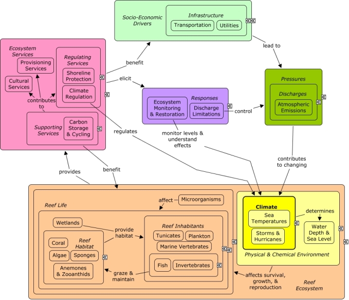
Atmospheric emissions of greenhouse gases including CO2 contribute to changing climate, including rising sea surface temperatures, rising sea level, and increasing intensity or frequency of storm events, such as hurricanes. Minor changes in sea surface temperatures can affect the growth, reproduction, and survival of reef species. Pathogen growth and disease outbreaks may be accelerated in warm waters, and extended periods of elevated temperatures are known to cause coral bleaching. Storm events can cause direct damage to reef habitat, fish, and invertebrates, but also alter patterns of seawater flow, redistributing contaminants or modulating high sea surface temperatures. Changes in reef condition will impact the availability of ecosystem goods and services, including climate regulation through carbon storage and cycling, and shoreline protection that can ameliorate the damaging effects of storms. Many of the same socio-economic sectors that cause pollution benefit indirectly from goods and services provided by the reef, such as recreational opportunities or essential habitat for fish and other invertebrates. Monitoring and scientific research can be used to track climate change and better understand the consequences for reef life. Discharge limitations, such as point-source controls, can be used to control atmospheric pollution.Citations
More than 50 citations. Click here to load.
| Citation | Year | Study Location | Study Type | Database Topics |
|---|
Management Options
| Management Option | Description | Sources | Database Topics |
|---|---|---|---|
| Agriculture & Aquaculture: Waterspreading | This management option uses a system of dams, dikes, ditches, or other means of diverting or collecting runoff from natural channels, gullies, or streams and spreading it over relatively flat areas. Waterspreading differs from irrigation in that applications are timed by the availability of natural runoff flow rather than scheduled to meet plant needs. Waterspreading is most beneficial in areas with an average annual precipitation of 8 to 25 inches. | Natural Resources Conservation Service. 2011. National Handbook of Conservation Practices. U.S. Department of Agriculture. |
Agriculture; Agriculture, Aquaculture, & Forestry Policies; Food & Raw Materials; Landuse Management; Surface & Groundwater Flow; Water; Water Resources |
| Corporate Response: Standardized Environmental Certifications and Labels | Product labeling initiatives are based on the premise that product information represented by or contained on the label is otherwise not readily available (or apparent) and is of value in consumer purchase decisions. For example, warning labels highlight product safety and toxic exposure hazards and advise consumers on ways to minimize risks. Likewise, a number of environmental certification programs (ECPs) identify products' environmental burdens and/or set standards for products' environmental attributes. Properly designed environmental labeling efforts can change consumer and manufacturer attitudes and behaviors, thus reducing environmental burdens. The specific metrics used to measure environmental label effectiveness include: 1) consumer awareness of labels, 2) consumer acceptance of labels (credibility and understanding), 3) changes in consumer behavior, 4) changes in manufacturer behavior, and 5) improvement of end goals, such as environmental quality. | Malcohn, E., Bentham Paulos, Andrew Stoeckle, Herbert Han-Pu Wang, and Julie Lynch. Determinants of Effectiveness for Environmental Certification and Labeling Programs. EPA-742-R-94-001, US EPA, Washington, DC. |
Agriculture; Agriculture, Aquaculture, & Forestry Policies; Aquaculture; Banks, Credit, & Securities; Climate; CO2; Collaboration & Partnering; Commercial Fisheries; Corporate Responses; Economic Markets & Policies; Environmental Education & Outreach; Fishing Sector; Food & Energy Policies; Food, Beverage, & Tobacco Products; Forestry; Health; Manufacturing & Trade; Manufacturing & Trade Policies; Marine Birds; Medical Care; Medical Centers; Metals, Electronics, & Machinery Products; Resource Use Management; Toxics; Transportation; Utilities; Whales & Dolphins; Wholesale & Retail Trade; Wood, Plastics, & Chemical Products |
| Damage Assessment, Documentation & Response: Respond to Mass Coral Bleaching Events | There are several actions managers can take to prepare for and respond to bleaching events. These strategies typically focus on developing and communicating reliable information about the bleaching event and its impacts, rather than providing a "cure." Developing a Bleaching response plan in advance allows managers to respond more effectively during these rapid onset events. Predicting the risk and severity of bleaching events can allow for more timely yet credible information for decision makers. After the bleaching event it is important to quickly access the ecological impacts for further management decisions. Bleached coral are in a vulnerable state, and are therefore less resilient to degraded water quality, physical damage from recreation, or pressure from fishing activities. This heightened sensitivity means that current protections may need to be increased temporarily following a bleaching event. | Marshall, P. and H. Schuttenberg. 2006. A reef manager's guide to coral bleaching. |
Atmospheric Emissions; Biological Monitoring & Restoration; Biological Monitoring, Mapping, & Scientific Research; Climate; Climate Regulation; Coral; Decision Support; Ecosystem Monitoring & Restoration; Environmental Education & Outreach; Environmental Monitoring & Restoration; Funding & Incentives; Greenhouse Gas Emissions; Sea Temperatures |
| Damage Assessment, Documentation & Response: Respond to Natural Resource Injuries from Natural Physical Disturbance | There are currently no standardized or uniform protocols to follow after natural or catastrophic events (such as hurricanes). Such protocols need to be developed in order to respond to specific issues that follow catastrophic natural events. | NOAA Marine Sanctuary Program. 2007. Florida Keys National Marine Sanctuary revised management plan. National Ocean Service, Key West, FL. |
Biological Monitoring & Restoration; Biological Monitoring, Mapping, & Scientific Research; Climate; Dredging Regulations; Ecosystem Monitoring & Restoration; Environmental Monitoring & Restoration; Environmental Monitoring, Mapping, & Scientific Research; Physical & Chemical Environment; Physical Damage; Physical Variables; Resource Use Management; Special Use Permitting; Storms & Hurricanes; Wetland & Reef Restoration |
| Data Management & Decision Tools: Develop an Ecological Information System | Spatial and temporal information about ecological resources should be incorporated into an existing local GIS or database. Information should include benthic habitats, species distributions and life histories, water quality, etc. These will act as baseline data for ecological monitoring. If previously established, the management option #165, will allow this data to be combined with updated data from other inventory management options such as #76, and future integration into larger databases, such as that in the management option #85 or 165. | NOAA Marine Sanctuary Program. 2007. Florida Keys National Marine Sanctuary revised management plan. National Ocean Service, Key West, FL. U.S. Coral Reef Task Force. 2000. The National Action Plan to Conserve Coral Reefs. Washington, D.C. |
Biological Monitoring & Restoration; Biological Monitoring, Mapping, & Scientific Research; Chemical Variables; Climate; Decision Support; Ecosystem Monitoring & Restoration; Environmental Monitoring & Restoration; Environmental Monitoring, Mapping, & Scientific Research; Physical & Chemical Water Quality Criteria; Physical Variables; Reef Habitat; Reef Life |
| Monitor & Research: Monitor Water Temperature | Extreme water temperature fluctuations can lead to bleaching and disease in corals and mass mortality of seagrass. Recording thermographs are deployed throughout the sanctuary area to monitor seawater temperatures. Temperatures fluctuate greatly, meaning monitoring should be continued long term, and that historic data must be considered to discern trends. | NOAA Marine Sanctuary Program. 2007. Florida Keys National Marine Sanctuary revised management plan. National Ocean Service, Key West, FL. |
Atmospheric Emissions; Climate; Climate Regulation; Ecosystem Monitoring & Restoration; Environmental Monitoring & Restoration; Environmental Monitoring, Mapping, & Scientific Research; Physical & Chemical Environment; Physical & Chemical Water Quality Criteria; Physical Variables; Regulating Services; Sea Temperatures |
| Monitor & Research: Research Global Change | This management option involves research to examine the effects of stresses associated with global change on the ecosystem. Stresses can include changes in temperature, hydrology, salinity, frequency and intensity of storms, turbidity, sea level change, and ultra violet and visible radiation. | NOAA Marine Sanctuary Program. 2007. Florida Keys National Marine Sanctuary revised management plan. National Ocean Service, Key West, FL. |
Atmospheric Emissions; Calcium Carbonate Deposition; Carbon Storage & Cycling; Chemical Variables; Climate; Climate Regulation; CO2; Discharges; Ecosystem Monitoring & Restoration; Environmental Monitoring & Restoration; Environmental Monitoring, Mapping, & Scientific Research; Greenhouse Gas Emissions; Nutrient & Contaminant Processing; Ocean Acidity; Physical & Chemical Water Quality Criteria; Physical Variables; Regulating Services; Salinity; Sea Temperatures; Seawater Flow; Shoreline Protection; Storms & Hurricanes; Supporting Services; Surface & Groundwater Flow; Water Depth & Sea Level |
| Monitor & Research: Water Quality Status and Trends Monitoring | This activity produces long-term, comprehensive information on sanctuary-wide status and trends of water quality parameters. Parameters that should be measured include temperature, salinity, dissolved oxygen, turbidity, relative fluorescence, light attenuation, nutrients, chlorophyll, and alkaline phosphatase activity. | NOAA Marine Sanctuary Program. 2007. Florida Keys National Marine Sanctuary revised management plan. National Ocean Service, Key West, FL. |
Applied Chemicals; Atmospheric Emissions; Calcium Carbonate Deposition; Carbon Storage & Cycling; Chemical Variables; Climate; Climate Regulation; CO2; Discharges; Ecosystem Monitoring & Restoration; Environmental Monitoring & Restoration; Environmental Monitoring, Mapping, & Scientific Research; Light; Nutrient & Contaminant Processing; Nutrients; Ocean Acidity; Physical & Chemical Water Quality Criteria; Physical Variables; Regulating Services; Salinity; Sea Temperatures; Sediment; Supporting Services; Toxics; Waterborne Discharges |
| Monitor & Research: Research Artificial Reef Siting, Size, and Materials Impact for Future Management Decisions | The effects of artificial reefs on fish and invertebrate abundance and community composition and on other sanctuary resources need to be assessed. Siting and size considerations should include spatial components such as nearest natural reef, species connectivity, currents, distance to shore, expected use, hurricane occurances, etc. The longevity of artificial reefs composed of different materials needs to be evaluated and considered heavily. | National Oceanic and Atmospheric Administration. 2007. National Artificial Reef Plan: Guidelines for Siting, Construction, Development, and Assessment of Artificial Reefs. US Department of Commerce. NOAA Marine Sanctuary Program. 2007. Florida Keys National Marine Sanctuary revised management plan. National Ocean Service, Key West, FL. |
Artificial Habitat; Biological Addition; Biological Monitoring & Restoration; Biological Monitoring, Mapping, & Scientific Research; Chemical Variables; Complex Habitat & Resources; Coral; Cultural Services; Decision Support; Ecosystem Monitoring & Restoration; Educational & Research Opportunities; Environmental Monitoring & Restoration; Finfish & Shellfish Stock; Fish; Invertebrates; Marine Debris; Physical Variables; Provisioning Services; Public Administration; Recreational Opportunities; Reef Habitat; Reef Inhabitants; Reef Life; Regulating Services; Seawater Flow; Security & Public Administration Policies; Shoreline Protection; Sponges; Storms & Hurricanes; Substrate; Tourism & Recreation Policies; Toxics; Water Resources; Wetland & Reef Restoration |
| Restoration: Beach Vegatation Restoration | Natural beaches are often host to important costal dune ecosystems. Due to tourism, much of the vegetation that comprises these dune ecosystems may be compromised. The natural vegetation provides an important ecosystem service, with roots providing deep stabilization against physical damage and removal of that sand. Without such vegetation sand and dunes can be completely washed away during hurricanes and other surge events. The dunes themselves offer some protection to nearby inland infrastructure during these same storm events. When the beach past the dunes is for public access it is beneficial to build raised walk-overs over the dune vegetation. This prevents trampling, which leads to dune blowouts. | Natural Resources Conservation Service, editor. 2007. Native Plants for Coastal Dune Restoration: What, When, and How for Florida. US Department of Agriculture. |
Beaches & Nature Parks; Biological Monitoring & Restoration; Culture; Deforestation & Devegetation; Ditching & Soil Disturbance; Ecosystem Monitoring & Restoration; Invasive Species; Landscape Changes; Landscape Conservation & Restoration; Landuse Management; Physical Damage; Regulating Services; Storms & Hurricanes; Tourism & Recreation; Trampling |
| Stormwater BMPs: Stormwater Pollution Reduction Through Instituting Preventitive Best Management Practices | This method focuses on reducing the amount of harmful contaminants in stormwater runoff by establishing Best Management Practices that prevent the generation of the pollutant to begin with. These BMPs include educational programs, infrastructure improvements and agricultural BMPs. Examples of educational programs would be programs that educate the public on the importance of, and how to avoid depositing hazardous wastes, such as oil, into storm drains, or how to use landscape management controls to limit the chemical and debris that from enter stormwater runoff from their personal lawns. Infrastructure improvement could include the use of alternative turnarounds and street cleaning. Agricultural practices such as roofs and covers for pesticides and equipment, or use of bedding are both preventative stormwater practices. Some additional specific practices include: controlling fertilizer application, properly using and disposing of fertilizers, pesticides, motor oil, and other harmful chemicals, debris removal, exposure reduction, minimization of pollutants, parking lot cleaning, stormwater catch basin insert, eliminate curbs and gutters, green parking, green roofs, street design and patterns, bedding. | NOAA Marine Sanctuary Program. 2007. Florida Keys National Marine Sanctuary revised management plan. National Ocean Service, Key West, FL. Natural Resources Conservation Service. 2011. National Handbook of Conservation Practices. U.S. Department of Agriculture. US EPA. Alternative Turnarounds. National Pollutant Discharge Elimination System Menu of BMPs Accessed 3/25/2011. US EPA. Eliminate Curbs and Gutters. National Pollutant Discharge Elimination System Menu of BMPs Accessed 3/25/2011. US EPA. Green Parking. National Pollutant Discharge Elimination System Menu of BMPs Accessed 3/25/2011. US EPA. Green Roofs. National Pollutant Discharge Elimination System Menu of BMPs Accessed 3/25/2011. US EPA. Street Design and Patterns. National Pollutant Discharge Elimination System Menu of BMPs Accessed 3/25/2011. Natural Resources Conservation Service. Urban BMP's - Water Runoff Management. Urban BMP's - Water Runoff Management Accessed 3/25/2011. Irrigation Association. 2010. Turf and Landscape Irrigation Best Management Practices. |
Agriculture; Applied Chemicals; Chemical Use Regulations; Chemical Variables; City Planning; Construction Codes & Projects; Discharge Limitations; Discharges; Environmental Education & Outreach; Food & Energy Policies; Food & Raw Materials; Forestry; Housing; Hydrologic Management; Infrastructural Policies; Infrastructure; Land-Based Civil Engineering; Landscape Changes; Landscape Conservation & Restoration; Landscaping & Household Services; Landuse Management; Mining; Nutrient & Contaminant Processing; Nutrients; Oil & Gas Industry; Road Construction & Maintenance; Security & Public Administration Policies; Shelter; Solid Waste Disposal; Storms & Hurricanes; Stormwater Management; Supporting Services; Toxics; Utilities; Waste Management; Waste Management Policies; Waterborne Discharges |
| Stormwater BMPs: Structural Stormwater Filtration | This method attempts to reduce the negative impacts of stormwater runoff through implementation of engineering structures that trap or filter impurities out of runoff water. These include but are not limited to, using swales, filter strips, oil/water separators, oil/grit separators, and sand filters. Often structural retrofitting is coupled with biological filters/controls to direct water as desired and to fully reap the benefits of both systems. Structural filters are often incorporated into retention/detention and infiltration systems as well. One disadvantage of structural filters is that they are often higher maintenance as sand and chambers fill and clog with pollutants over time. | NOAA Marine Sanctuary Program. 2007. Florida Keys National Marine Sanctuary revised management plan. National Ocean Service, Key West, FL. Natural Resources Conservation Service. Compost Filter System. Urban BMP's - Water Runoff Management Accessed 3/23/2011. Natural Resources Conservation Service. Dry Swale. Urban BMP's - Water Runoff Management Accessed 3/23/2011. Natural Resources Conservation Service. Median Strip Infiltration Trench. Urban BMP's - Water Runoff Management Accessed 3/23/2011. Natural Resources Conservation Service. Montgomery County Water Quality Inlet. Urban BMP's - Water Runoff Management Accessed 3/23/2011. Natural Resources Conservation Service. Off-Line Infiltration Basin. Urban BMP's - Water Runoff Management Accessed 3/23/2011. Natural Resources Conservation Service. Oil/Water Separators. Urban BMP's - Water Runoff Management Accessed 3/23/2011. Natural Resources Conservation Service. Organic Sand Filter. Urban BMP's - Water Runoff Management Accessed 3/23/2011. Natural Resources Conservation Service. Peat Sand Filter. Urban BMP's - Water Runoff Management Accessed 3/23/2011. Natural Resources Conservation Service. Perimeter Sand Filter. Urban BMP's - Water Runoff Management Accessed 3/23/2011. Natural Resources Conservation Service. Pocket Sand Filter. Urban BMP's - Water Runoff Management Accessed 3/23/2011. Natural Resources Conservation Service. Rockville Water Quality Inlet. Urban BMP's - Water Runoff Management Accessed 3/23/2011. Natural Resources Conservation Service. Sediment Basin (Water Quality Enhancement). Urban BMP's - Water Runoff Management Accessed 3/23/2011. Natural Resources Conservation Service. Side-by-Side Infiltration Basin. Urban BMP's - Water Runoff Management Accessed 3/23/2011. Natural Resources Conservation Service. Surface Sand Filter. Urban BMP's - Water Runoff Management Accessed 3/23/2011. Natural Resources Conservation Service. Underground Sand Filter. Urban BMP's - Water Runoff Management Accessed 3/23/2011. Natural Resources Conservation Service. Underground Trench with Oil/Grit Chamber. Urban BMP's - Water Runoff Management Accessed 3/23/2011. Natural Resources Conservation Service. Under-the-Swale Infiltration Trench. Urban BMP's - Water Runoff Management Accessed 3/23/2011. Natural Resources Conservation Service. Water Quality Volume (WQV) Storage Tank. Urban BMP's - Water Runoff Management Accessed 3/23/2011. Water Environment Research Foundation, American Society of Civil Engineers, U.S. Environmental Protection Agency, Federal Highway Administration, American Public Works Association, editor. 2008. Overview of Performance by BMP Category and Common Pollutant Type. International Stormwater Best Management Practices (BMP) Database [1999-2008]. Leisenring, M., Clary, J., Stephenson, J., and Hobson, P. 2010. International Stormwater Best Management Practices (BMP) Database Pollutant Category Summary: Nutrients. Geosyntec Consultants, Inc. US EPA. EPA Filtration BMPs. National Pollutant Discharge Elimination System Menu of BMPs Accessed 3/25/2011. US EPA. Manufactured Products for Stormwater Inlets. National Pollutant Discharge Elimination System Menu of BMPs Accessed 3/25/2011. US EPA. Alum Injection. National Pollutant Discharge Elimination System Menu of BMPs Accessed 3/25/2011. Natural Resources Conservation Service. 2010. Stormwater Runoff Controls. U.S. Depatrment of Agriculture. Natural Resources Conservation Service. 2005. Solid/liquid Waste Separation Facility. U.S. Depatrment of Agriculture. |
Applied Chemicals; Chemical Variables; City Planning; Civil Engineering & Construction; Coastal Engineering; Construction Codes & Projects; Dam Construction & Maintenance; Discharge Limitations; Discharges; Ditching & Soil Disturbance; Food & Energy Policies; Hydrologic Management; Impervious Surfaces; Improved Technology; Infrastructural Policies; Infrastructure; Land-Based Civil Engineering; Landscape Changes; Landscape Conservation & Restoration; Landuse Management; Non-point Source Controls; Non-point Source Runoff; Physical Variables; Point & Mobile Source Controls; Point Source Discharges; Road Construction & Maintenance; Sediment; Storms & Hurricanes; Stormwater Management; Surface & Groundwater Flow; Toxics; Utilities; Utility Policies; Waste Management; Waste Management Policies; Wastewater Discharge; Waterborne Discharges |
| Stormwater BMPs: Structural Stormwater Infiltration | This management option attempts to reduce the negative impacts of stormwater runoff through implementation of engineering structures that control the volume of surface water, facilitating faster absorption of the stormwater into the ground. Often these structures are able to infiltrate larger amounts of water faster while reducing exposure to surface sediments and pollutants. | Natural Resources Conservation Service. Combined Infiltration/Detention Basin. Urban BMP's - Water Runoff Management Accessed 3/23/2011. Leisenring, M., Clary, J., Stephenson, J., and Hobson, P. 2010. International Stormwater Best Management Practices (BMP) Database Pollutant Category Summary: Nutrients. Geosyntec Consultants, Inc. Poresky, A., Clary, J., Strecker, E., and Earles, A. 2011. International Stormwater Best Management Practices (BMP) Database. Technical Summary: Volume Reduction. Geosyntec Consultants. US EPA. EPA Infiltration BMPs. National Pollutant Discharge Elimination System Menu of BMPs Accessed 3/25/2011. |
Applied Chemicals; Chemical Variables; City Planning; Civil Engineering & Construction; Climate; Coastal Development; Construction Codes & Projects; Deforestation & Devegetation; Discharge Limitations; Discharges; Ditching & Soil Disturbance; Drinking Water Supply; Fertilizer & Pesticide Use; Hydrologic Management; Impervious Surfaces; Infrastructural Policies; Irrigation; Land-Based Civil Engineering; Landscape Changes; Landuse Management; Non-point Source Controls; Non-point Source Runoff; Point Source Discharges; Sediment; Storms & Hurricanes; Stormwater Management; Substrate; Supporting Services; Surface & Groundwater Flow; Waste Management Policies; Wastewater Discharge; Water; Waterborne Discharges |
| Stormwater BMPs: Structural Stormwater Retention/Detention | This method attempts to reduce the negative impacts of stormwater runoff through implementation of engineering structures that retain runoff water for further treatment or controlled release. Water collection can be selective, targeting the first flush of water, which is typically the most polluted. Water retention has the additional benefit of later release at a place and time when the water is needed (e.g. for irrigation). Rainwater Collection Systems (#11) can be an important water resource in areas where freshwater is limited. | Natural Resources Conservation Service. 2011. National Handbook of Conservation Practices. U.S. Department of Agriculture. Natural Resources Conservation Service. Combined Infiltration/Detention Basin. Urban BMP's - Water Runoff Management Accessed 3/23/2011. Natural Resources Conservation Service. Detention Devices for Dry/Wet Ponds. Urban BMP's - Water Runoff Management Accessed 3/23/2011. Natural Resources Conservation Service. Dry Extended Detention Ponds. Urban BMP's - Water Runoff Management Accessed 3/23/2011. Leisenring, M., Clary, J., Stephenson, J., and Hobson, P. 2010. International Stormwater Best Management Practices (BMP) Database Pollutant Category Summary: Nutrients. Geosyntec Consultants, Inc. Poresky, A., Clary, J., Strecker, E., and Earles, A. 2011. International Stormwater Best Management Practices (BMP) Database. Technical Summary: Volume Reduction. Geosyntec Consultants. Natural Resources Conservation Service. 2010. Stormwater Runoff Controls. U.S. Depatrment of Agriculture. Natural Resources Conservation Service. 2008. Water and Sediment Control Basin. CODE 638. U.S. Depatrment of Agriculture. Natural Resources Conservation Service. Water Volume Management. Urban BMP's - Water Runoff Management Accessed 3/25/2011. |
Agriculture, Aquaculture, & Forestry Policies; Applied Chemicals; Chemical Variables; City Planning; Civil Engineering & Construction; Climate; Coastal Development; Construction Codes & Projects; Deforestation & Devegetation; Discharge Limitations; Discharges; Ditching & Soil Disturbance; Hydrologic Management; Impervious Surfaces; Infrastructural Policies; Infrastructure; Land-Based Civil Engineering; Landscape Changes; Landuse Management; Non-point Source Controls; Non-point Source Runoff; Physical Variables; Point Source Discharges; Sediment; Shoreline Armoring; Storms & Hurricanes; Stormwater Management; Substrate; Surface & Groundwater Flow; Utilities; Utility Policies; Waste Management; Waste Management Policies; Wastewater Discharge; Water; Waterborne Discharges |
| Stormwater BMPs: Rainwater Collection Systems | Creating a rainwater collection system (either through policy change or the initiative of homeowners) would help in many ways. These systems would utilize water in an efficient manner. It would reduce the pressure of water as a finite resource. Water would be collected and utilized before it reaches the ground. Once rain falls to the ground, it picks up nutrients, chemicals, and pathogens on the ground and transports them in the form of runoff. Eventually this contaminated stormwater runoff enters water resources through the drainage basin. Collecting a considerable amount of water would prevent contamination of that water, and allow for it to be usable. Also, it would reduce the amount of water that is lost when it is contaminated as runoff. An overall reduced amount of stormwater runoff would reduce the amount of contaminants that would harm corals. | Center for Watershed Protection. 2008. Guanica Bay watershed management plan. Natural Resources Conservation Service. Cisterns used for water harvesting. Urban BMP's - Water Runoff Management Accessed 3/18/2011. Leisenring, M., Clary, J., Stephenson, J., and Hobson, P. 2010. International Stormwater Best Management Practices (BMP) Database Pollutant Category Summary: Nutrients. Geosyntec Consultants, Inc. |
Applied Chemicals; Building & Home Construction; Chemical Variables; City Planning; Civil Engineering & Construction; Cleaner & Solvent Use; Climate; Construction Codes & Projects; Deforestation & Devegetation; Discharge Limitations; Discharges; Ditching & Soil Disturbance; Drinking Water Supply; Fertilizer & Pesticide Use; Food & Energy Policies; Impervious Surfaces; Infrastructural Policies; Infrastructure; Irrigation; Land-Based Civil Engineering; Landscape Changes; Landscaping & Household Services; Landuse Management; Non-point Source Controls; Non-point Source Runoff; Physical Variables; Point & Mobile Source Controls; Point Source Discharges; Sediment; Shelter; Storms & Hurricanes; Stormwater Management; Substrate; Surface & Groundwater Flow; Toxics; Utilities; Utility Policies; Waste Management; Waste Management Policies; Wastewater Discharge; Water; Water Utilities Policies; Waterborne Discharges |
| Stormwater BMPs: Sustained Reservoir Minimum Release of Minimum Baseflow to Sustain Aquatic Habitat | In some regions, even high intensity rivers (e.g. Rio Loco, Puerto Rico) are seasonal, drying for long enough to kill aquatic vegetation. Creating a constant baseflow would help sustain aquatic life and ultimately help to process nutrients. High intensity rivers are already prone to extreme channel erosion from the high flow rates, this erosion is even greater without any benthic biota to hold sediment on the river bottom. Restricting the release of reservoir water to that required to maintain aquatic biota would reduce the intensity of flow, stabilize the river bottom, create habitat and naturally process nutrients that could potentially contribute to eutrophication out on the coral reef. | Center for Watershed Protection. 2008. Guanica Bay watershed management plan. Natural Resources Conservation Service. 2011. National Handbook of Conservation Practices. U.S. Department of Agriculture. |
Algae; Biological Monitoring & Restoration; Climate; Dam Construction & Maintenance; Discharge Limitations; Discharges; Ditching & Soil Disturbance; Drinking Water Supply; Ecosystem Monitoring & Restoration; Hydrologic Management; Infrastructural Policies; Infrastructure; Land-Based Civil Engineering; Landscape Changes; Landuse Management; Nutrient & Contaminant Processing; Physical Variables; Point Source Discharges; Pressures; Primary Production; Reef Habitat; Reef Life; Regulating Services; Storms & Hurricanes; Stormwater Management; Surface & Groundwater Flow; Utilities; Waste Management; Water; Waterborne Discharges; Wetland & Reef Restoration; Wetlands |
| Stormwater BMPs: Biological Stormwater Retention/Detention | This method attempts to reduce the negative impacts of stormwater runoff through implementation of natural structures that retain runoff water for further treatment or controlled release. These structures are typically characterized as retention ponds and incorporate natural vegetation such as grass. These ponds may be dry, or may drain into nearby wetlands. | Natural Resources Conservation Service. 2011. National Handbook of Conservation Practices. U.S. Department of Agriculture. Natural Resources Conservation Service. Dry Extended Detention Ponds. Urban BMP's - Water Runoff Management Accessed 3/23/2011. Poresky, A., Clary, J., Strecker, E., and Earles, A. 2011. International Stormwater Best Management Practices (BMP) Database. Technical Summary: Volume Reduction. Geosyntec Consultants. |
Applied Chemicals; Chemical Variables; City Planning; Civil Engineering & Construction; Discharge Limitations; Discharges; Hydrologic Management; Infrastructural Policies; Irrigation; Land-Based Civil Engineering; Landscape Changes; Landscape Conservation & Restoration; Landuse Management; Non-point Source Controls; Non-point Source Runoff; Nutrient & Contaminant Processing; Physical Variables; Point & Mobile Source Controls; Point Source Discharges; Primary Production; Sediment; Storms & Hurricanes; Stormwater Management; Substrate; Supporting Services; Surface & Groundwater Flow; Toxics; Utilities; Utility Policies; Waste Management; Waste Management Policies; Wastewater Discharge; Water; Waterborne Discharges |
| Stormwater BMPs: Biological Stormwater Filtration | This method attempts to reduce the negative impacts of stormwater runoff through implementing engineering techniques that allow natural processes and plants to act as filters. Such techniques would include using grass parking and turf covered swales. Many of these techniques, such as reversed elevations for planted areas in parking lots, can demonstrate benefits both as natural filters and for the vegetation that are used since it eliminates the need to water them with irrigation systems. | NOAA Marine Sanctuary Program. 2007. Florida Keys National Marine Sanctuary revised management plan. National Ocean Service, Key West, FL. Natural Resources Conservation Service. 2011. National Handbook of Conservation Practices. U.S. Department of Agriculture. Natural Resources Conservation Service. Basic Biofiltration Swale. Urban BMP's - Water Runoff Management Accessed 3/23/2011. Natural Resources Conservation Service. Bioretention System. Urban BMP's - Water Runoff Management Accessed 3/23/2011. Natural Resources Conservation Service. Constructed Wetland. Urban BMP's - Water Runoff Management Accessed 3/23/2011. Natural Resources Conservation Service. Filter Strips. Urban BMP's - Water Runoff Management Accessed 3/23/2011. Natural Resources Conservation Service. Reversed Elevations System for Parking Lots and Planting Areas. Urban BMP's - Water Runoff Management Accessed 3/23/2011. Natural Resources Conservation Service. Riparian Forest Buffer. Urban BMP's - Water Runoff Management Accessed 3/23/2011. Natural Resources Conservation Service. Roadway Landscape Treatment System. Urban BMP's - Water Runoff Management Accessed 3/23/2011. Natural Resources Conservation Service. Wet Biofiltration Swale. Urban BMP's - Water Runoff Management Accessed 3/23/2011. Natural Resources Conservation Service. Wet Pond Design. Urban BMP's - Water Runoff Management Accessed 3/23/2011. Natural Resources Conservation Service. Wet Swale. Urban BMP's - Water Runoff Management Accessed 3/23/2011. Water Environment Research Foundation, American Society of Civil Engineers, U.S. Environmental Protection Agency, Federal Highway Administration, American Public Works Association, editor. 2008. Overview of Performance by BMP Category and Common Pollutant Type. International Stormwater Best Management Practices (BMP) Database [1999-2008]. Leisenring, M., Clary, J., Stephenson, J., and Hobson, P. 2010. International Stormwater Best Management Practices (BMP) Database Pollutant Category Summary: Nutrients. Geosyntec Consultants, Inc. |
Applied Chemicals; Building & Home Construction; Chemical Variables; City Planning; Civil Engineering & Construction; Climate; Construction Codes & Projects; Deforestation & Devegetation; Discharge Limitations; Discharges; Ditching & Soil Disturbance; Fertilizer & Pesticide Use; Golf Course Operations; Impervious Surfaces; Infrastructure; Irrigation; Land-Based Civil Engineering; Landscape Changes; Landscape Conservation & Restoration; Landscaping & Household Services; Landuse Management; Non-point Source Controls; Non-point Source Runoff; Nutrient & Contaminant Processing; Physical Variables; Point & Mobile Source Controls; Point Source Discharges; Primary Production; Road Construction & Maintenance; Sediment; Storms & Hurricanes; Stormwater Management; Substrate; Supporting Services; Surface & Groundwater Flow; Toxics; Utilities; Waste Management; Waste Management Policies; Wastewater Discharge; Water; Waterborne Discharges |
| Transportation Policy: Corporate Average Fuel Economy Standards | The purpose of Corporate Average Fuel Economy (CAF�) standards is to reduce fuel consumption by increasing the fuel economy of cars and light trucks. NHTSA sets fuel economy standards for cars and light trucks sold in the US while EPA calculates the average fuel economy for each manufacturer. Since the standard only dictates the average fuel economy, manufacturers can sell vehicles with higher or lower fuel economy than the standard. | National Highway Traffic Safety Administration. Corporate Average Fuel Economy (CAFE). Accessed 8/11/2011. |
Atmospheric Emissions; Carbon Storage & Cycling; Climate; Climate Regulation; CO2; Energy Policy & Development; Food & Energy Policies; Greenhouse Gas Emissions; Land & Air Transportation; Manufacturing & Trade; Manufacturing & Trade Policies; Non-Greenhouse Gas Emissions; Ocean Acidity; Oil & Gas Industry; Provisioning Services; Regulating Services; Resource Use Management; Supporting Services; Transportation; Transportation Policies |
| Waterway Management: Control River Volume Using Dams and Resevoirs | Constructing dams and creating reservoirs can have many affects, both positive and negative. Like smaller scale structural stormwater retention (#263), this management option retains groundwater for later controlled release. On this scale, the creation of a reservoir may require flooding of an area behind the dam that had other uses (e.g. agriculture). Proper vegetation can be used in and around the reservoir to incorporate biological filtration (#261). Slowing the release of water into rivers reduces the intensity of flow, reducing channel erosion. However, water should still be released consistently to allow for aquatic habitat to be maintained on the river bottom (#8). Lastly, with the correct infrastructure, a dam can be used as a sustainable hydroelectric energy source. | Morris, G.L., Fan, J. 1998. Reservoir Sedimentation Handbook: Design and management of dams, reservoirs, and watersheds for sustainable use. Ver. 1.04 edition. McGraw-Hill, New York, NY. Environmental Protection Agency. 2007. National Management Measures to Control Nonpoint Source Pollution from Hydromodification. EPA 841-B-07-002, Office of Water, Washington, DC. |
Civil Engineering & Construction; Climate; Dam Construction & Maintenance; Discharge Limitations; Discharges; Energy Policy & Development; Hydrologic Management; Improved Technology; Infrastructural Policies; Infrastructure; Land-Based Civil Engineering; Non-point Source Runoff; Nutrient & Contaminant Processing; Physical Variables; Point Source Discharges; Storms & Hurricanes; Stormwater Management; Utilities; Utility Policies; Waste Management; Water; Waterborne Discharges; Wetlands |
Laws
| Legal Citation | Purpose of Law | Management Organization | Database Topics |
|---|---|---|---|
| Rules and Procedures for Coastal Construction and Excavation, 62B-033 Florida Administrative Code (2008). | (1) The beach and dune system is an integral part of the coastal system and represents one of the most valuable natural resources in Florida, providing protection to adjacent upland properties, recreational areas, and habitat for wildlife. A coastal construction control line (CCCL) is intended to define that portion of the beach and dune system which is subject to severe fluctuations caused by a 100-year storm surge, storm waves, or other forces such as wind, wave, or water level changes. These fluctuations are a necessary part of the natural functioning of the coastal system and are essential to post-storm recovery, long term stability, and the preservation of the beach and dune system. However, imprudent human activities can adversely interfere with these natural processes and alter the integrity and functioning of the beach and dune system. The control line and 50-foot setback call attention to the special hazards and impacts associated with the use of such property, but do not preclude all development or alteration of coastal property seaward of such lines.
(2) In order to demonstrate that construction is eligible for a permit, the applicant shall provide the Department with sufficient information pertaining to the proposed project to show that adverse and other impacts associated with the construction have been minimized and that the construction will not result in a significant adverse impact.
(3) After reviewing all information required pursuant to this rule chapter, the Department shall:
(a) Deny any application for an activity which either individually or cumulatively would result in a significant adverse impact including potential cumulative effects. In assessing the cumulative effects of a proposed activity, the Department shall consider the short-term and long-term impacts and the direct and indirect impacts the activity would cause in combination with existing structures in the area and any other similar activities already permitted or for which a permit application is pending within the same fixed coastal cell. The impact assessment shall include the anticipated effects of the construction on the coastal system and marine turtles. Each application shall be evaluated on its own merits in making a permit decision; therefore, a decision by the Department to grant a permit shall not constitute a commitment to permit additional similar construction within the same fixed coastal cell.
(b) Deny any application for an activity where the project has not met the Department�s siting and design criteria; has not minimized adverse and other impacts, including stormwater runoff; or has not provided mitigation of adverse impacts.
(4) The Department shall issue a permit for construction which an applicant has shown to be clearly justified by demonstrating that all standards, guidelines, and other requirements set forth in the applicable provisions of Part I, Chapter 161, F.S., and this rule chapter are met, including the following:
(a) The construction will not result in removal or destruction of native vegetation which will either destabilize a frontal, primary, or significant dune or cause a significant adverse impact to the beach and dune system due to increased erosion by wind or water;
(b) The construction will not result in removal or disturbance of in situ sandy soils of the beach and dune system to such a degree that a significant adverse impact to the beach and dune system would result from either reducing the existing ability of the system to resist erosion during a storm or lowering existing levels of storm protection to upland properties and structures;
(c) The construction will not direct discharges of water or other fluids in a seaward direction and in a manner that would result in significant adverse impacts. Forthe purposes of this rule section, construction shall be designed so as to minimize erosion induced surface water runoff within the beach and dune system and to prevent additional seaward or off-site discharges associated with a coastal storm event.
(d) The construction will not result in the net excavation of the in situ sandy soils seaward of the control line or 50-foot setback;
(e) The construction will not cause an increase in structure-induced scour of such magnitude during a storm that the structure-induced scour would result in a significant adverse impact;
(f) The construction will minimize the potential for wind and waterborne missiles during a storm;
(g) The activity will not interfere with public access, as defined in Section 161.021, F.S.; and
(h) The construction will not cause a significant adverse impact to marine turtles, or the coastal system.
(5) In order for a manmade frontal dune to be considered as a frontal dune defined under Section 161.053(6)(a)1., F.S., the manmade frontal dune shall be constructed to meet or exceed the protective value afforded by the natural frontal dune system in the immediate area of the subject shoreline. Prior to the issuance of a permit for a single-family dwelling meeting the criteria of Section 161.053(6)(c), F.S., the manmade frontal dune must be maintained for a minimum of 12 months and be demonstrated to be as stable and sustainable as the natural frontal dune system.
(6) Sandy material excavated seaward of the control line or 50-foot setback shall be maintained on site seaward of the control line or 50-foot setback and be placed in the immediate area of construction unless otherwise specifically authorized by the Department.
(7) Swimming pools, wading pools, waterfalls, spas, or similar type water structures are expendable structures and shall be sited so that their failure does not have adverse impact on the beach and dune system, any adjoining major structures, or any coastal protection structure. Pools sited within close proximity to a significant dune shall be elevated either partially or totally above the original grade to minimize excavation and shall not cause a net loss of material from the immediate area of the pool. All pools shall be designed to minimize any permanent excavation seaward of the CCCL.
(8) Major structures shall be located a sufficient distance landward of the beach and frontal dune to permit natural shoreline fluctuations, to preserve and protect beach and dune system stability, and to allow natural recovery to occur following storm-induced erosion. Where a rigid coastal structure exists, proposed major structures shall be located a sufficient distance landward of the rigid coastal structure to allow for future maintenance or repair of the rigid coastal structure. Although fishing piers shall be exempt from this provision, their foundation piles shall be located so as to allow for the maintenance and repair of any rigid coastal structure that is located in close proximity to the pier.(9) If in the immediate area a number of existing major structures have established a reasonably continuous and uniform construction line and if the existing structures have not been unduly affected by erosion, except where not allowed by the requirements of Section 161.053(6), F.S., and this rule chapter, the Department shall issue a permit for the construction of a similar structure up to that line.
(10) In considering applications for single-family dwellings proposed to be located seaward of the 30-year erosion projection pursuant to Section 161.053(6), F.S., the Department shall require structures to meet criteria in Section 161.053(6)(c), F.S., and all other siting and design criteria established in this rule chapter.
(11) In considering project impacts to native salt-tolerant vegetation, the Department shall evaluate the type and extent of native salt-tolerant vegetation, the degree and extent of disturbance by invasive nuisance species and mechanical and other activities, the protective value to adjacent structures and natural plant communities, the protective value to the beach and dune system, and the impacts to marine turtle nesting and hatchlings. The Department shall restrict activities that lower the protective value of natural and intact beach and dune, coastal strand, and maritime hammock plant communities. Activities that result in the removal of protective root systems or reduce the vegetation�s sand trapping and stabilizing properties of salt tolerant vegetation are considered to lower its protective value. Construction shall be located, where practicable, in previously disturbed areas or areas with non-native vegetation in lieu of areas of native plant communities when the placement does not increase adverse impact to the beach and dune system. Planting of invasive nuisance plants, such as those listed in the Florida Exotic Pest Plant Council�s 2005 List of Invasive Species � Categories I and II, will not be authorized if the planting will result in removal or destruction of existing dune-stabilizing native vegetation or if the planting is to occur on or seaward of the dune system. A copy of this list is available on the Internet at www.fleppc.org; or can be obtained by writing to the Department of Environmental Protection, Bureau of Beaches and Coastal Systems, 3900 Commonwealth Boulevard, Mail Station 300, Tallahassee, Florida 32399-3000; or by telephoning (850) 488-7708. Special conditions relative to the nature, timing, and sequence of construction and the remediation of construction impacts shall be placed on permitted activities when necessary to protect native salt-tolerant vegetation and native plant communities. A construction fence, a designated location for construction access or storage of equipment and materials, and a restoration plan shall be required if necessary for protection of existing native salt-tolerant vegetation during construction.
(12) Special conditions relative to the nature, timing, and sequence of construction shall be placed on permitted activities when necessary to protect marine turtles and their nests and nesting habitat. In marine turtle nesting areas, all forms of lighting shall be shielded or otherwise designed so as not to disturb marine turtles. Tinted glass or similar light control measures shall be used for windows and doors which are visible from the nesting areas of the beach. The Department shall suspend any permitted construction when the permittee has not provided the required protection for marine turtles and their nests and nesting habitat. Application to Coral Reefs:Regulation of coastal construction through permit review and modification will protect coastal ecosystems from degradation and loss and in doing so protects other marine ecosystems including coral reefs. Legislative Actions:Chapter 62B-33 Florida Administrative Code, provides the design and siting requirements that must be met to obtain a coastal construction control line permit.Approval or denial of a permit application is based upon a review of the potential impacts to the beach dune system, adjacentproperties, native salt resistant vegetation, and marine turtles. Comments:The Coastal Construction Control Line (CCCL) is an essential element of Florida's coastal management program. It provides protection for Florida's beaches and dunes while assuring reasonable use of private property. Recognizing the value of the state's beaches, the Florida legislature initiated the Coastal Construction Contorl Line Program to protect the coastal system from improperly sited and designed structures which can destabilize or destroy the beach and dune system. Once destabilized, the valuable natural resources are lost, as are its important values for recreation, upland property protection and environmental habitat. Adoption of a coastal construction line establishes an area of jurisdiction in which special siting and design criteria are applied for construction and related activities.These standards may be more stringent than those already applied in the rest of the coastal building zone because of the greater forces expected to occur in the more seaward zone of the beach during a storm event. |
Florida State Department of Environmental Protection Jurisdiction: State Coastal Waters; Designated Marine Areas |
Beach & Land Formation; Building & Home Construction; City Planning; Civil Engineering & Construction; Coastal Development; Construction Codes & Projects; Cruise Ships; Docks & Marinas; Dredging Regulations; Dredging, Draining, & Filling; Hydrologic Management; Landuse Management; Mangroves; Marine Protected Areas; Oil & Gas Tankers; Pipelines; Ports & Harbors; Resource Use Management; Seagrasses; Seawater Flow; Sediment; Shoreline Armoring; Shoreline Protection; Storms & Hurricanes; Tourism & Recreation Policies; Water Depth & Sea Level |