ReefLink Database
Boat Movement
Boating activities include movement of boats and ships through deep or shallow water, as well as in and out of harbor or around buoys.
CMap
CMap Description
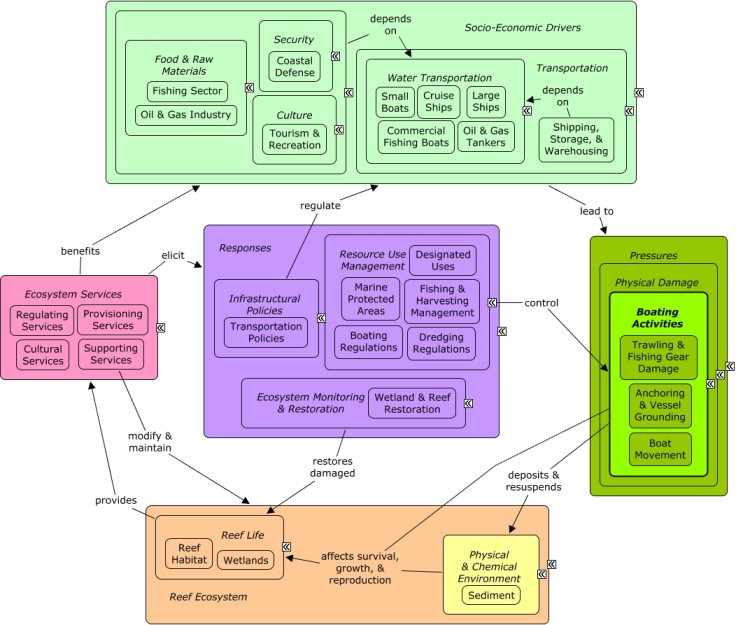
Fishing, tourism, recreation, shipping, and coastal defense rely on water transportation. Boat and ship activities can lead to groundings, anchor drops, or use of fishing gear that can damage reef habitat, and movement can cause deposition and resuspension of sediment in the reef environment. Fishing gear, such as trawling nets, can damage deepwater reefs, or cause injury to reef inhabitants, including fish and larger vertebrates. Many of the same socio-economic sectors that cause physical damage through boating activities also benefit from reef ecosystem services, including recreational value, shoreline protection, and provision of seafood and other marine products. Resource use management can be used to minimize physical damage by establishing protected areas and boating regulations, such as mooring buoys, fines, and low-wake zones to minimize sediment resuspension or groundings. Fishing regulations can influence activities and locations of fishing boats and types of fishing gear used.Citations
| Citation | Year | Study Location | Study Type | Database Topics |
|---|
Management Options
| Management Option | Description | Sources | Database Topics |
|---|---|---|---|
| Damage Assessment, Documentation & Response: Respond to Natural Resource Injuries form Derelict Vessels | Semi- permanent/permanent vessels can have a negative impact on the surrounding local environment both due to the effects of shade and from the direct contact with the substrate. Sunken vessels that cannot be seen from the surface may present a danger to navigation. Derelict vessels that do not remain stationary may cause harm in multiple locations before becoming stationary. If fishing gear is still intact, it may cause further biological damage through "ghost fishing� (#283). Early response, creating mooring fields, pump-out stations, and providing support for removing derelict vessels, reduces the impact of these vessels. Also, the removal of intrusive vessels will help contribute to the restoration of reef areas to previous conditions. | NOAA Marine Sanctuary Program. 2007. Florida Keys National Marine Sanctuary revised management plan. National Ocean Service, Key West, FL. |
Anchoring & Vessel Grounding; Artificial Habitat; Artisanal Fishing; Biological Monitoring & Restoration; Boat Movement; Boating Activities; Boating Regulations; Coastal Defense; Commercial Fishing Boats; Coral; Ecosystem Monitoring & Restoration; Environmental Monitoring & Restoration; Large Ships; Marine Debris; Military; Physical Damage; Reef Habitat; Reef Life; Resource Use Management; Seagrasses; Small Boats; Stony Coral; Substrate; Transportation Policies; Water Depth & Sea Level; Water Transportation; Wetlands |
| Damage Assessment, Documentation & Response: Operating Permits for Towing & Salvage Professionals | This management option evaluates the need for a permitting system for all towing and salvage operations. This type of permit would require salvage operators to notify injury response when there are groundings. The permit program would also reduce impacts by ensuring operators know the proper practices and use the proper equipment to most effectively minimize damage to the operating area. | NOAA Marine Sanctuary Program. 2007. Florida Keys National Marine Sanctuary revised management plan. National Ocean Service, Key West, FL. |
Anchoring & Vessel Grounding; Boat Movement; Boating Activities; Boating Regulations; Contact Uses; Dredging Regulations; Physical Damage; Resource Use Management; Special Use Permitting; Water Transportation |
| Environmental Education: Deliver Non-Enforcement Resource Eductaion at the Resource Site | Voluntary compliance (#50) is the most desirable form of site protection. Lack of compliance often occurs unintentionally, due to a lack of knowledge and understanding. Law enforcement plays a role by ensuring rules are appropriately followed, but often the preventative component of this enforcement becomes secondary, especially on high use days/areas. Volunteers can assist by answering questions and talking to people recreating about the reef, reef resources, and how to appropriately recreate. Volunteers can watch to ensure people are acting appropriately, that boaters do not go too close to shallow reefs, and that groundings do not occur. Programs such as Team OCEAN have contributed over 15,000 hours to such activities. | NOAA Marine Sanctuary Program. 2007. Florida Keys National Marine Sanctuary revised management plan. National Ocean Service, Key West, FL. |
Beaches & Nature Parks; Boat Movement; Boating Activities; Collaboration & Partnering; Cultural Policies; Culture; Dive, Snorkeling, & Swimming Tourism; Education & Information; Environmental Education & Outreach; Finfish Harvest; Invertebrate Harvest; Marine Debris; Recreational Fishing; Recreational Opportunities; Resource Use Management; Social Organizations; Sunscreen Use; Tourism & Recreation; Tourism & Recreation Policies; Trampling |
| Fishing & Harvesting Management: Research Low-impact Fishing Gear & Methods | Facilitating research to develop gear designs and fishing methods that minimize impacts is multifaceted. Ideal fishing gear is selective for the target species and sizes, with negligible direct or indirect impact on non-target species, sizes and habitats; but also efficient, giving quality, high catches at the lowest possible cost. Newly developed low-impact gear allows fishermen to fulfill their needs, providing food and income, while lessening the unintended environmental impact of those activities, like by-catch. Before an agency should promote new fishing gear or methods research is important to ensure there are no un-intended environmental tradeoffs. Biodegradable fishing line, modified traps, and buoy lines are examples of gear types that could be studied. | NOAA Marine Sanctuary Program. 2007. Florida Keys National Marine Sanctuary revised management plan. National Ocean Service, Key West, FL. Seas At Risk. 2009. Moving Towards Low Impact Fisheries In Europe Policy Hurdles & Actions. |
Accidental & Illegal Harvest; Anchoring & Vessel Grounding; Artisanal Fishing; Biological Harvest; Boat Movement; Commercial Fisheries; Contact Uses; Finfish & Shellfish Stock; Finfish Harvest; Fish; Fishing & Harvesting Management; Fishing Sector; Improved Technology; Invasive Species; Invertebrate Harvest; Live Collection; Marine Debris; Physical Damage; Recreational Fishing; Reef Habitat; Resource Use Management; Trawling & Fishing Gear Damage |
| Marine Zoning: Sanctuary Preservation Areas (SPAs) | This is a type of Marine Zoning used by the Florida Keys National Marine Sanctuary (FKNMS). SPAs focus on the protection of shallow, heavily used reefs where conflicts occur between user groups, and where concentrated visitor activity leads to resource degradation. They are designed to enhance the reproductive capabilities of renewable resources, protect areas critical for sustaining and protecting important marine species, and reduce user conflicts in high-use areas. This is accomplished through a prohibition of consumptive activities within these areas. They have been chosen based on the status of important habitat, the ability of a particular area to sustain and protect the habitat, the level of visitor use, and the degree of conflict between consumptive and non-consumptive users. The actual size and location of these zones have been determined by examination of user patterns, aerial photography, and ground-truthing of specific habitats. | NOAA Marine Sanctuary Program. 2007. Florida Keys National Marine Sanctuary revised management plan. National Ocean Service, Key West, FL. |
Accidental & Illegal Harvest; Anchoring & Vessel Grounding; Aquaculture; Aquarium & Pet Trade; Aquarium Stock; Artisanal Fishing; Beaches & Nature Parks; Biological Addition; Biological Harvest; Biological Monitoring & Restoration; Boat Movement; Boating Activities; Boating Regulations; Coastal Defense; Coastal Development; Coastal Engineering; Commercial Fisheries; Commercial Fishing Boats; Complex Habitat & Resources; Cruise Ships; Cultural Services; Decision Support; Designated Uses; Dive, Snorkeling, & Swimming Tourism; Dredging Regulations; Dredging, Draining, & Filling; Ecosystem Monitoring & Restoration; Educational & Research Opportunities; Entertainment & Accommodation Services; Environmental Monitoring & Restoration; Finfish & Shellfish Stock; Finfish Harvest; Fisheries & Hunting Policies; Fishing & Harvesting Management; Fishing Sector; Invertebrate Harvest; Landscape Changes; Large Ships; Live Collection; Marine Protected Areas; Oil & Gas Tankers; Ornamental Jewelry & Art; Permitting & Zoning; Physical Damage; Public Administration; Recreational Fishing; Recreational Opportunities; Resource Use Management; Security; Small Boats; Souvenir & Decorative Trade; Supporting Services; Tourism & Recreation; Tourism & Recreation Policies; Trampling; Travel Services & Tour Operators; Trawling & Fishing Gear Damage; Water Resources; Water Transportation |
| Regulatory Review and Development: Evaluate Channel & Reef Navigation Markers | This option would evaluate the need for proper marking to ensure better navigation. There are many types of markers, including buoys, charts, beacons, and GPS mapping. Such markers can also be used to advocate prohibition on vessel speeds greater than idle speed in areas designated as idle-speed only/no-wake and around shallow reef locations. | NOAA Marine Sanctuary Program. 2007. Florida Keys National Marine Sanctuary revised management plan. National Ocean Service, Key West, FL. |
Anchoring & Vessel Grounding; Beach & Land Formation; Boat Movement; Boating Activities; Boating Regulations; Coastal Development; Contact Uses; Cultural Services; Culture; Decision Support; Designated Uses; Dive, Snorkeling, & Swimming Tourism; Dredging Regulations; Permitting & Zoning; Physical Damage; Provisioning Services; Public Administration; Recreational Fishing; Recreational Opportunities; Security & Public Administration Policies; Small Boats; Tourism & Recreation; Trampling; Transportation Policies; Water Depth & Sea Level; Water Resources; Water Transportation |
| Regulatory Review and Development: Change Salvaging & Towing Practices | This option seeks to protect natural resources and reduce damage resulting from improper vessel salvage methods. In the past, salvage techniques have caused collateral damage when removing vessels grounded on the reef. These injuries often occur in the immediate area surrounding the grounded vessel but can be avoided with the use of proper salvage techniques developed with reef resources in mind. The principal causes of collateral injuries are dragging a vessel off the reef instead of floating it off; the use of steel towing cables that can drop on or drag across the substrate, impacting and dislodging resources (reef structure, corals, and sponges); and propwash and surge, generated by tugboat propellers, that displace sediment and dislodge organisms. To avoid or minimize collateral injuries, a reconnaissance survey should be conducted while the vessel is grounded to evaluate reef resources in the immediate area surrounding the vessel and determine an appropriate extraction route. Bunker fuel and cargo may need to be offloaded. Floating or buoyed towlines should be used instead of steel cables, and towing activities should be conducted at or near high tide to facilitate floating the vessel. Before and during the extraction, global positioning system (GPS) coordinates at the bow and stern of the vessel should be recorded to assist with future injury assessment. GPS tracking should be operating on the grounded vessel during egress from the site and on all salvage vessels or tugboats involved with the salvage operation. The outbound path for vessel extraction may also need to be buoyed, to help avoid or identify injuries that may occur during the salvage operation. | NOAA Marine Sanctuary Program. 2007. Florida Keys National Marine Sanctuary revised management plan. National Ocean Service, Key West, FL. |
Anchoring & Vessel Grounding; Boat Movement; Boating Activities; Boating Regulations; Coastal Engineering; Collaboration & Partnering; Contact Uses; Decision Support; Dredging Regulations; Dredging, Draining, & Filling; Environmental Education & Outreach; Improved Technology; Infrastructural Policies; Physical Damage; Resource Use Management; Security & Public Administration Policies; Trampling; Transportation; Transportation Policies; Water Transportation |
| Regulatory Review and Development: Change Personal Watercraft & Other Small Vessels Practices | This activity would aim to reduce noise and pollution, and conflicts among PWC users, the resources, and Sanctuary users. Practices could be changed through requiring certain training to drive such vessels, or restricting which types can be used in designated coastal areas. | NOAA Marine Sanctuary Program. 2007. Florida Keys National Marine Sanctuary revised management plan. National Ocean Service, Key West, FL. |
Anchoring & Vessel Grounding; Boat Movement; Boating Activities; Boating Regulations; Contact Uses; Designated Uses; Physical Damage; Recreational Fishing; Small Boats; Tourism & Recreation; Tourism & Recreation Policies; Water Transportation |
| Resource Use Management: Fisheries Catch Quotas | Quotas designate the Total Allowable Catch (TAC) allocated to an operating unit such as a country, a vessel, a company or an individual fisherman (individual quota) depending on the system of allocation. Quotas may or may not be transferable, inheritable, and tradable. While generally used to allocate total allowable catch, quotas could be used also to allocate fishing effort or biomass. | Seas At Risk. 2009. Moving Towards Low Impact Fisheries In Europe Policy Hurdles & Actions. |
Accidental & Illegal Harvest; Anchoring & Vessel Grounding; Apex Fish Predators; Artisanal Fishing; Biological Harvest; Bivalves; Boat Movement; Boating Activities; Commercial Fisheries; Commercial Fishing Boats; Finfish & Shellfish Stock; Finfish Harvest; Fish; Fisheries & Hunting Policies; Fishing & Harvesting Management; Fishing Sector; Food & Raw Materials; Invertebrate Harvest; Invertivorous Fish; Large Herbivorous Fish; Live Collection; Lobster, Crab, & Shrimp; Marine Products; Molluscs; Octopus & Squid; Piscivorous Fish; Planktivorous Fish; Provisioning Services; Recreational Fishing; Snails & Conch; Trawling & Fishing Gear Damage |
| Waterway Management: Waterway Management/Marking Plan | Proper waterway markings provide coherent guidance for boats. Clearly-marked waterway exits and entrances reduce the probability of damage to reefs from boat gear damage, boat movement, trampling, and ballast discharge. Waterway marking can be achieved through surveying damage from propeller scarring and vessel groundings, enhancing channel marking aids, assessing the effectiveness of channel marking, and through removing waterway obstructions. "Hotspots" where many incidents have been reported should be considered for further marking, especially those that are in high use areas. | NOAA Marine Sanctuary Program. 2007. Florida Keys National Marine Sanctuary revised management plan. National Ocean Service, Key West, FL. |
Anchoring & Vessel Grounding; Boat Movement; Boating Activities; Boating Regulations; Contact Uses; Decision Support; Dredging Regulations; Dredging, Draining, & Filling; Physical Damage; Resource Use Management; Trampling; Trawling & Fishing Gear Damage; Water; Water Transportation |
| Waterway Management: Stream Bank Riparian Plantings | Planting native vegetation and trees in riparian zones helps to reduce erosion within channels. Such vegetation helps anchor the soil and sediment in place. Planting in riparian zones goes in hand with Remove Previous Canal and Irrigation Infrastructure (#274). This management option can be exercised in streams, canals used for boat passage, stormwater drainage ditches, or in agricultural irrigation channels. | Center for Watershed Protection. 2008. Guanica Bay watershed management plan. Natural Resources Conservation Service. 2011. National Handbook of Conservation Practices. U.S. Department of Agriculture. |
Agriculture; Agriculture, Aquaculture, & Forestry Policies; Boat Movement; Boating Activities; Carbon Storage & Cycling; City Planning; Civil Engineering & Construction; Coastal Development; Construction Codes & Projects; Deforestation & Devegetation; Discharge Limitations; Discharges; Ditching & Soil Disturbance; Ecosystem Monitoring & Restoration; Food & Energy Policies; Forestry; Hydrologic Management; Infrastructural Policies; Infrastructure; Irrigation; Landscape Changes; Landscape Conservation & Restoration; Landuse Management; Nutrient & Contaminant Processing; Primary Production; Provisioning Services; Sediment; Stormwater Management; Supporting Services; Surface & Groundwater Flow; Transportation; Utilities; Water; Water Resources; Water Transportation; Waterborne Discharges |
| Waterway Management: Remove Previous Canal and Irrigation Infrastructure | Canal and irrigation infrastructure typically includes concrete structures to control the flow of water. These low head dams, bulkheads, concrete footers, and other structures act as constricting forces in channels. This constriction leads to debris becoming lodged and thus changing the erosive forces. In turn, banks become destabilized. Channel erosion then increases along with bed scour and sediment transport. Removing these structures and making banks more gradual has the added benefit of allowing for riparian vegetation to be planted, which acts as a natural buffer. | Center for Watershed Protection. 2008. Guanica Bay watershed management plan. |
Agriculture; Agriculture, Aquaculture, & Forestry Policies; Boat Movement; Boating Activities; City Planning; Civil Engineering & Construction; Coastal Engineering; Construction Codes & Projects; Dam Construction & Maintenance; Deforestation & Devegetation; Discharge Limitations; Discharges; Ditching & Soil Disturbance; Ecosystem Monitoring & Restoration; Environmental Monitoring & Restoration; Food & Raw Materials; Hydrologic Management; Impervious Surfaces; Infrastructural Policies; Irrigation; Land-Based Civil Engineering; Landscape Changes; Landscape Conservation & Restoration; Landuse Management; Non-point Source Controls; Physical Damage; Sediment; Shoreline Protection; Small Boats; Substrate; Surface & Groundwater Flow; Transportation; Water; Water Resources; Water Transportation; Waterborne Discharges |
| Waterway Management: Manage Canal Water Quality | This management option addresses water quality issues that may arise from nearshore, confined areas, specifically dead-end canals. This management response does not focus on wastewater discharges into canals, but instead on the hydrologic structure and orientation of the canal itself. Physical problems with canal orientation can lead to such problems as low flushing and build-up of weed wrack. This is a problem because the build-up of weed wrack consumes oxygen and releases nutrients as it decays. When combined with low flushing and circulation, dead end canals have decreased oxygen concentrations, accelerated eutrophication, and accumulate organic materials, pollutants and sediment. To improve the current canal system, management can inventory and map canals to identify high risk hotspots and candidates for future canal restoration projects. Canals are typically constructed to best suit the water access needs of local homes and businesses. Preventing high risk canals from being constructed, or placing certain requirements on their construction through permitting is one way to reduce future problem spots. Some design strategies include: Construct non-linear canals without right-angles and flared inlets oriented to prevailing winds. Instead of dead-ends, canals should include a flow through water exchange system or install mechanical pumps. Canals should be as wide as possible in relation to depth and length. Canal depth should be uniform or progressively shallower away from the parent waterbody, with sloping banks (eliminate requirements for navigable depths to shoreline). Some canal improvement strategies include: Implement weed gates, air curtains, and aeration systems. Direct all stormwater and effluent away from canal systems. Reduce bulkheading and restore native vegetative buffers (#1). Promote diversity of substrates and habitats. | NOAA Marine Sanctuary Program. 2007. Florida Keys National Marine Sanctuary revised management plan. National Ocean Service, Key West, FL. |
Applied Chemicals; Biological Monitoring & Restoration; Boat Movement; Boating Activities; Building & Home Construction; Chemical Variables; City Planning; Civil Engineering & Construction; Coastal Development; Coastal Engineering; Construction Codes & Projects; Decision Support; Deforestation & Devegetation; Discharge Limitations; Discharges; Ditching & Soil Disturbance; Docks & Marinas; Ecosystem Monitoring & Restoration; Environmental Monitoring & Restoration; Fishing Sector; Food & Energy Policies; Hydrologic Management; Improved Technology; Infrastructural Policies; Infrastructure; Land-Based Civil Engineering; Landscape Changes; Landscaping & Household Services; Landuse Management; Non-point Source Controls; Non-point Source Runoff; Nutrient & Contaminant Processing; Physical & Chemical Water Quality Criteria; Physical Damage; Physical Variables; Point & Mobile Source Controls; Point Source Discharges; Ports & Harbors; Provisioning Services; Regulating Services; Seawater Flow; Shoreline Armoring; Shoreline Protection; Small Boats; Surface & Groundwater Flow; Tourism & Recreation; Transportation; Transportation Policies; Utilities; Utility Policies; Waste Management; Waste Management Policies; Wastewater Discharge; Water; Water Depth & Sea Level; Water Resources; Water Transportation; Waterborne Discharges; Wetland & Reef Restoration; Wetlands |
| Waterway Management: Boat Access Plan | An optimal boat access strategy involves conducting a survey of all public and private boat access points throughout the area. Once entry and exit sites are identified, channel markings can be placed accordingly. An effective strategy must also consider boat access needs, location, and intensity of use. This will help to efficiently mark the waterways so that there can be a reduction in damage to reefs, seagrasses and wetlands. | NOAA Marine Sanctuary Program. 2007. Florida Keys National Marine Sanctuary revised management plan. National Ocean Service, Key West, FL. |
Anchoring & Vessel Grounding; Artisanal Fishing; Boat Movement; Boating Activities; Boating Regulations; Commercial Fisheries; Contact Uses; Cultural Policies; Culture; Decision Support; Dive, Snorkeling, & Swimming Tourism; Dredging, Draining, & Filling; Landscape Changes; Physical Damage; Public Administration; Recreational Fishing; Resource Use Management; Security; Security & Public Administration Policies; Tourism & Recreation; Tourism & Recreation Policies; Trampling; Transportation; Trawling & Fishing Gear Damage; Water; Water Resources; Water Transportation |
Laws
| Legal Citation | Purpose of Law | Management Organization | Database Topics |
|---|---|---|---|
| Amendment to the Florida Keys National Marine Sanctuary Regulations revising the boundary of the northernmost area to be avoided off the coast of Florida, Federal Register § Volume 65, Number226 (2000). | NOAA, in conjunction with the US Coast Guard, proposed to revise the northernmost area to be avoided (ATBA) off the coast of the Florida Keys. The change was expected to increaase maritime safety and to avoid harm to the marine environment and its resources. Application to Coral Reefs:The amendments directly protect coral reefs because the change of the nothernmost area presented in the regulation as Area To Be Avoided resulted in large vessels not entering the area that had been the site of large vessel groundings. Legislative Actions: Comments: |
National Oceanic and Atmospheric Administration in conjunction with the US Coast Guard Jurisdiction: US Coral Reefs; State Coastal Waters; US State Waters; Designated Marine Areas |
Anchoring & Vessel Grounding; Boat Movement; Civil Engineering & Construction; Commercial Fishing Boats; Coral; Cruise Ships; Fish; Large Ships; Oil & Gas Tankers; Physical Damage; Reef Inhabitants; Transportation Policies; Water Transportation |
| Biscayne Bay Aquatic Preserve, 18-18 Florida Administrative Code. | 18-18.001 Intent.
(1) The Biscayne Bay Aquatic Preserve, the boundaries of which are fully described in Rule 18-18.002, F.A.C., was established for the purpose of preserving and enhancing Biscayne Bay and all natural waterways tidally connected to the bay in an essentially natural condition so that its biological and aesthetic values may endure for the enjoyment of future generations.
(2) These rules shall apply to all lands public and private within the boundaries of the preserve. However, privately owned uplands shall be excluded from these rules except as otherwise provided for herein.
(3) In promulgating and implementing these rules, it is the intent of the Department to construe the provisions of Sections 258.397 and 258.35 through 258.46, F.S., together and to apply the more stringent statutory provisions for the maintenance of the preserve.
(4) The preserve shall be administered and managed in accordance with the following goals:
(a) To preserve, protect, and enhance Biscayne Bay and all natural waterways tidally connected to the bay by reasonable regulation of human activity within the preserve through the development and implementation of a comprehensive management program;
(b) To protect and enhance the waters of the preserve so that the public may continue to enjoy the traditional recreational uses of those waters such as swimming, boating and fishing;
(c) To coordinate with federal, state, and local agencies to aid in carrying out the intent of the legislature in creating the preserve;
(d) To use applicable federal, state, and local management programs, which are compatible with the intent and provisions of the Act and these rules, to assist in managing the preserve;
(e) To encourage activities that protect or enhance the biological and aesthetic values of the preserve, including but not limited to the modification of existing manmade conditions towards their natural condition, when reviewing applications or developing and implementing management plans for the preserve;
(f) To preserve and promote indigenous life forms and habitats including but not limited to sponges, soft corals, hard corals, seagrasses, mangroves, mud flats, marine reptiles, game and non-game fish species, marine mammals, tropical marine invertebrates, birds and shellfish;
(g) To acquire additional title interests in land wherever such acquisitions would serve to protect or enhance the biological or aesthetic values of the preserve. Application to Coral Reefs:Biscayne Bay Aquatic Preserve protection of water quality will contribute to a lowering of contaminants leaving the preserve on tides and thus limiting the contaminants that reach off-shore ecosystems including the FKNMS and the reef system within the sanctuary. Legislative Actions: Comments:This chapter establishes the rules to protect the Biscayne Bay Aquatic Preserve, which was established for the purpose of preserving and enhancing Biscayne Bay and all natural waterways tidally connected to the bay in an essentially natural condition so that its biological and aesthetic values may endure for the enjoyment of future generations. |
Florida State Department of Environmental Protection Jurisdiction: Designated Marine Areas |
Accidental & Illegal Harvest; Anchoring & Vessel Grounding; Ballast Discharge; Boat Movement; Coastal Development; Docks & Marinas; Dredging Regulations; Dredging, Draining, & Filling; Environmental Education & Outreach; Existence Value & Sense of Place; Finfish & Shellfish Stock; Finfish Harvest; Hydrologic Management; Landuse Management; Mangroves; Marine Birds; Marine Debris; Nutrients; Point Source Discharges; Recreational Opportunities; Resource Use Management; Seagrasses; Seawater Flow; Sediment; Sewage Treatment; Small Boats; Waste Management Policies; Wastewater Discharge |
| Proposed Coral Reef Conservation Act Amendments of 2005, 2007 and 2009,. | To preserve, sustain, and restore the condition of coral reef ecosystems, to promote the wise management and sustainable use of coral reef ecosystems, to benefit local communities and the Nation, to develop sound scientific information on the condition of coral reef ecosystems and threats to the ecosystems, to assist in the preservation of coral reefs by supporting and financing conservation programs including local and non-governmental programs, establish a formal mechanism for collecting and allocating monetary donations from the private sector to be used for coral reef conservation projects Application to Coral Reefs:When passed, the Amendments, among other issues, would reauthorize the Coral Reef Conservation Act of 2000 and authorize appropriations through fiscal 2012 for the coral reef conservation program and community- based planning grants. Will authorize activities designed to minimize the likelihood of vessel impacts or other physical dammage to coral reefs, including activities to identify certain at-risk coral reefs. Promote international cooperation, codify the US Coral Reef Task Force. Legislative Actions:Provided funding for matching grants, encouraged education and outreach, encouaged cooperative conservation and management through partnerships with other federal, state, regional and local partners including citizen groups. Comments:The amendments would not add regulations to the Act. |
National Oceanic and Atmospheric Administration Jurisdiction: US Coral Reefs |
Anchoring & Vessel Grounding; Ballast Discharge; Boat Movement; CO2; Coral; Dive, Snorkeling, & Swimming Tourism; Educational & Research Opportunities; Existence Value & Sense of Place; Fertilizer & Pesticide Use; Finfish & Shellfish Stock; Lobster, Crab, & Shrimp; Recreational Opportunities; Reef Habitat; Reef Inhabitants; Sediment; Tourism & Recreation; Water Transportation |