ReefLink Database
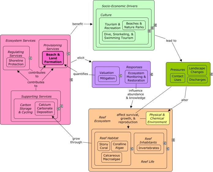
Beach & Land Formation
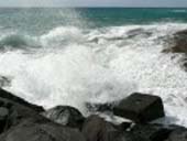
Sand production is the process by which calcified coral skeletons and invertebrate shells break down, forming sand which replenishes beaches. Historic reefs may provide the foundation for land formation, such as creation of islands.
CMap
CMap Description
A number of reef organisms, including stony coral, calcareous macroalgae, crustose coralline algae, crustaceans, mollusks, and bivalves, deposit calcium carbonate during growth to form hard skeletons or shells. As coral and other calcified organisms break down they provide sand which replenishes sandy beaches. Calcium carbonate deposition by coral contributes to the strong reef structure which can form the foundation for land masses such as islands. Wave attenuation by reefs protects the shoreline, reducing rates at which land is lost due to erosion. Many of the same economic sectors which benefit from reefs also create pressures on them through harvesting, as well as contributing to coastal development and pollution. Decision-makers can better understand the value of reef goods through valuation methods. Economic markets, including supply and demand, will influence the value of reef products.Citations
| Citation | Year | Study Location | Study Type | Database Topics |
|---|---|---|---|---|
| Principe, P., P. Bradley, S. Yee, W. Fisher, E. Johnson, P. Allen, and D. Campbell. 2012. Quantifying Coral Reef Ecosystem Services. EPA/600/R-11/206, U.S. Environmental Protection Agency, Research Triangle Park, NC. | 2012 | Global | Aquarium & Pet Trade; Aquarium Stock; Beach & Land Formation; Carbon Storage & Cycling; Complex Habitat & Resources; Corporate Responses; Cultural Policies; Cultural Protections; Cultural Services; Existence Value & Sense of Place; Fish; Landscape Conservation & Restoration; Mangroves; Monetary Valuation; Ornamental Jewelry & Art; Pharmaceuticals & Cosmetics; Pharmaceuticals & Cosmetics Sources; Provisioning Services; Regulating Services; Seagrasses; Shoreline Protection; Supporting Services; Tourism & Recreation; Valuation | |
| Diaz, C., M. L. Valenzuela, A. Laguna, V. Lavayen, J. Jimenez, L. A. Power, and C. O'Dwyer. 2010. Metallophosphazene Precursor Routes to the Solid-State Deposition of Metallic and Dielectric Microstructures and Nanostructures on Si and SiO2. Langmuir 26:10223-10233. | 2010 | Substrate | ||
| Mckoy, H., D. M. Kennedy, and P. S. Kench. 2010. Sand cay evolution on reef platforms, Mamanuca Islands, Fiji. Marine Geology 269:61-73. | 2010 | Fiji | Climate; Sediment; Shoreline Protection; Water Depth & Sea Level | |
| Jones, R. W. 2009. Stratigraphy, palaeoenvironmental interpretation and uplift history of Barbados based on foraminiferal and other palaeontological evidence. Journal of Micropalaeontology 28:37-44. | 2009 | GIS & Maps | ||
| Mosher, T., M. Mitchell, P. Lucey, E. Hochberg, M. Davidson, and S. Wassom. 2005. Progress toward launch: A review of 2004 HICO program activities. in IEEE Aerospace Conference Proceedings. | 2005 | US Pacific & Hawaii | Review; Lab Study; Remote Sensing | Beaches & Nature Parks |
| Schellmann, G. and U. Radtke. 2004. A revised morpho- and chronostratigraphy of the Late and Middle Pleistocene coral reef terraces on Southern Barbados (West Indies). Earth-Science Reviews 64:157-187. | 2004 | Model | Beach & Land Formation; Water Depth & Sea Level | |
| Brooke, B. P., C. D. Woodroffe, C. V. Murray-Wallace, H. Heijnis, and B. G. Jones. 2003. Quaternary calcarenite stratigraphy on Lord Howe Island, southwestern Pacific Ocean and the record of coastal carbonate deposition. Quaternary Science Reviews 22:859-880. | 2003 | US Pacific & Hawaii; Pacific Ocean | Beach & Land Formation; Sediment; Snails & Conch; Water Depth & Sea Level | |
| Goreau, T. J., W. Hilbertz, A. Azeez, A. Hakeem, and J. Allen. 2003. Shore protection, beach formation, and production of building materials and energy using seawater electrolysis technology. Page 2366 in Oceans Conference Record (IEEE). | 2003 | Beach & Land Formation; Calcium Carbonate Deposition | ||
| Hallock, P. 2000. Larger foraminifers as contributors to carbonate beach sands. Pages 97-98 in Carbonate Beaches 2000. | 2000 | US Pacific & Hawaii | Beach & Land Formation; Sediment | |
| Woodroffe, C. D., R. F. McLean, S. G. Smithers, and E. M. Lawson. 1999. Atoll reef-island formation and response to sea-level change: West Island, Cocos (Keeling) Islands. Marine Geology 160:85-104. | 1999 | Model; Index or Indicator | Sediment; Water Depth & Sea Level | |
| Carew, J. L., J. E. Mylroie, and S. J. Schwabe. 1998. The geology of South Andros Island, Bahamas: A reconnaissance report. Cave and Karst Science 25:57-66. | 1998 | Bahamas | Beach & Land Formation; Sediment | |
| Dixon, O. A. 1998. Heliolitine corals of the topmost Douro and overlying formations (Upper Silurian), Canadian Arctic Islands. Journal of Paleontology 72:937-966. | 1998 | |||
| Fleischer, R. C., C. E. McIntosh, and C. L. Tarr. 1998. Evolution on a volcanic conveyor belt: Using phylogeographic reconstructions and K-Ar-based ages of the Hawaiian Islands to estimate molecular evolutionary rates. Molecular Ecology 7:533-545. | 1998 | US Pacific & Hawaii | ||
| Landing, E. 1993. In situ earliest Cambrian tube worms and the oldest metazoan- constructed biostrome (Placentian Series, southeastern Newfoundland). Journal of Paleontology 67:333-342. | 1993 | Marine Worms; Snails & Conch | ||
| Nunn, P. D. 1993. Oceanic islands. Oceanic islands. | 1993 | Model | Climate | |
| Anon,. 1986. Amazone, First Cutter Suction Dredger Completed By Boelwerf, Belgium. Holland Shipbuilding 35:39-41. | 1986 | Beach & Land Formation; Dredging, Draining, & Filling | ||
| Hine, A. C. and J. C. Steinmetz. 1984. Cay Sal Bank, Bahamas - A partially drowned carbonate platform. Marine Geology 59. | 1984 | Bahamas; Cuba | Beach & Land Formation; Calcareous Macroalgae; Sediment; Water Depth & Sea Level | |
| Carlton, J. M. 1974. Land-building and stabilization by mangroves. Environmental Conservation 1:285-294. | 1974 | Florida | Field Study & Monitoring; Lab Study | Beach & Land Formation; Beaches & Nature Parks; Housing; Mangroves; Sediment; Shoreline Armoring; Substrate |
Management Options
| Management Option | Description | Sources | Database Topics |
|---|---|---|---|
| Regulatory Review and Development: Evaluate Dredging Regulations | Dredging is oftentimes prohibited with certain exceptions. Dredging regulation often falls under other controls over the alteration of the seabed, discharging or depositing materials. At times dredging is necessary for navigation or other activities, necessitating .permitting mechanisms for allowing otherwise prohibited activities. Revising the regulations to help eliminate negative dredge-and-fill activities within a certain distance of corals would be beneficial because it would help promote the reestablishment of sensitive benthic communities. Reservoirs may require periodic dredging to remove sediment that may have collected. | NOAA Marine Sanctuary Program. 2007. Florida Keys National Marine Sanctuary revised management plan. National Ocean Service, Key West, FL. |
Beach & Land Formation; Beaches & Nature Parks; Biological Monitoring & Restoration; Coastal Engineering; Construction Codes & Projects; Dam Construction & Maintenance; Decision Support; Discharge Limitations; Docks & Marinas; Dredging Regulations; Dredging, Draining, & Filling; Ecosystem Monitoring & Restoration; Hydrologic Management; Mining; Mining Policies; Physical Damage; Point Source Discharges; Ports & Harbors; Provisioning Services; Resource Use Management; Sand & Rock Production; Security & Public Administration Policies; Special Use Permitting; Substrate; Transportation; Utility Line Construction & Maintenance; Water Transportation |
| Regulatory Review and Development: Evaluate Channel & Reef Navigation Markers | This option would evaluate the need for proper marking to ensure better navigation. There are many types of markers, including buoys, charts, beacons, and GPS mapping. Such markers can also be used to advocate prohibition on vessel speeds greater than idle speed in areas designated as idle-speed only/no-wake and around shallow reef locations. | NOAA Marine Sanctuary Program. 2007. Florida Keys National Marine Sanctuary revised management plan. National Ocean Service, Key West, FL. |
Anchoring & Vessel Grounding; Beach & Land Formation; Boat Movement; Boating Activities; Boating Regulations; Coastal Development; Contact Uses; Cultural Services; Culture; Decision Support; Designated Uses; Dive, Snorkeling, & Swimming Tourism; Dredging Regulations; Permitting & Zoning; Physical Damage; Provisioning Services; Public Administration; Recreational Fishing; Recreational Opportunities; Security & Public Administration Policies; Small Boats; Tourism & Recreation; Trampling; Transportation Policies; Water Depth & Sea Level; Water Resources; Water Transportation |
| Restoration: Beach Renourishment and Nourishment | Beaches are subject to natural accretion and erosion. Tourism is often best supported by wide, accessible, public sandy beaches. Beaches can be restored to counteract natural erosion by transporting large quantities of sand onto the beach. This sand often comes from nearby dredging. Caution should be used when restoring long sections of beaches, as often the area above the mean high tide line is littoral, or privately owned, and restoration of these beaches can impact these property rights, see "Stop the Beach Renourishment, Inc. v. Florida Department of Environmental Protection (2010) U.S. Supreme Court decision." Beach protection or nourishment offers an alternative to this often expensive and abrupt type of renourishment, nourishment involves practices which encourage coastal accretion and discourage erosional forces. See "Florida's Beach and Shore Preservation Act" for some restrictions on this. | NOAA Coastal Services Center. Beach Nourishment: A Guide for Local Government Officials. Coastal Services Center Accessed 6/17/2011. |
Beach & Land Formation; Beaches & Nature Parks; Culture; Dredging, Draining, & Filling; Environmental Monitoring & Restoration; Landscape Conservation & Restoration; Recreational Opportunities; Shoreline Armoring; Shoreline Protection; Sunscreen Use; Tourism & Recreation |
Laws
| Legal Citation | Purpose of Law | Management Organization | Database Topics |
|---|---|---|---|
| Rules and Procedures for Coastal Construction and Excavation, 62B-033 Florida Administrative Code (2008). | (1) The beach and dune system is an integral part of the coastal system and represents one of the most valuable natural resources in Florida, providing protection to adjacent upland properties, recreational areas, and habitat for wildlife. A coastal construction control line (CCCL) is intended to define that portion of the beach and dune system which is subject to severe fluctuations caused by a 100-year storm surge, storm waves, or other forces such as wind, wave, or water level changes. These fluctuations are a necessary part of the natural functioning of the coastal system and are essential to post-storm recovery, long term stability, and the preservation of the beach and dune system. However, imprudent human activities can adversely interfere with these natural processes and alter the integrity and functioning of the beach and dune system. The control line and 50-foot setback call attention to the special hazards and impacts associated with the use of such property, but do not preclude all development or alteration of coastal property seaward of such lines.
(2) In order to demonstrate that construction is eligible for a permit, the applicant shall provide the Department with sufficient information pertaining to the proposed project to show that adverse and other impacts associated with the construction have been minimized and that the construction will not result in a significant adverse impact.
(3) After reviewing all information required pursuant to this rule chapter, the Department shall:
(a) Deny any application for an activity which either individually or cumulatively would result in a significant adverse impact including potential cumulative effects. In assessing the cumulative effects of a proposed activity, the Department shall consider the short-term and long-term impacts and the direct and indirect impacts the activity would cause in combination with existing structures in the area and any other similar activities already permitted or for which a permit application is pending within the same fixed coastal cell. The impact assessment shall include the anticipated effects of the construction on the coastal system and marine turtles. Each application shall be evaluated on its own merits in making a permit decision; therefore, a decision by the Department to grant a permit shall not constitute a commitment to permit additional similar construction within the same fixed coastal cell.
(b) Deny any application for an activity where the project has not met the Department�s siting and design criteria; has not minimized adverse and other impacts, including stormwater runoff; or has not provided mitigation of adverse impacts.
(4) The Department shall issue a permit for construction which an applicant has shown to be clearly justified by demonstrating that all standards, guidelines, and other requirements set forth in the applicable provisions of Part I, Chapter 161, F.S., and this rule chapter are met, including the following:
(a) The construction will not result in removal or destruction of native vegetation which will either destabilize a frontal, primary, or significant dune or cause a significant adverse impact to the beach and dune system due to increased erosion by wind or water;
(b) The construction will not result in removal or disturbance of in situ sandy soils of the beach and dune system to such a degree that a significant adverse impact to the beach and dune system would result from either reducing the existing ability of the system to resist erosion during a storm or lowering existing levels of storm protection to upland properties and structures;
(c) The construction will not direct discharges of water or other fluids in a seaward direction and in a manner that would result in significant adverse impacts. Forthe purposes of this rule section, construction shall be designed so as to minimize erosion induced surface water runoff within the beach and dune system and to prevent additional seaward or off-site discharges associated with a coastal storm event.
(d) The construction will not result in the net excavation of the in situ sandy soils seaward of the control line or 50-foot setback;
(e) The construction will not cause an increase in structure-induced scour of such magnitude during a storm that the structure-induced scour would result in a significant adverse impact;
(f) The construction will minimize the potential for wind and waterborne missiles during a storm;
(g) The activity will not interfere with public access, as defined in Section 161.021, F.S.; and
(h) The construction will not cause a significant adverse impact to marine turtles, or the coastal system.
(5) In order for a manmade frontal dune to be considered as a frontal dune defined under Section 161.053(6)(a)1., F.S., the manmade frontal dune shall be constructed to meet or exceed the protective value afforded by the natural frontal dune system in the immediate area of the subject shoreline. Prior to the issuance of a permit for a single-family dwelling meeting the criteria of Section 161.053(6)(c), F.S., the manmade frontal dune must be maintained for a minimum of 12 months and be demonstrated to be as stable and sustainable as the natural frontal dune system.
(6) Sandy material excavated seaward of the control line or 50-foot setback shall be maintained on site seaward of the control line or 50-foot setback and be placed in the immediate area of construction unless otherwise specifically authorized by the Department.
(7) Swimming pools, wading pools, waterfalls, spas, or similar type water structures are expendable structures and shall be sited so that their failure does not have adverse impact on the beach and dune system, any adjoining major structures, or any coastal protection structure. Pools sited within close proximity to a significant dune shall be elevated either partially or totally above the original grade to minimize excavation and shall not cause a net loss of material from the immediate area of the pool. All pools shall be designed to minimize any permanent excavation seaward of the CCCL.
(8) Major structures shall be located a sufficient distance landward of the beach and frontal dune to permit natural shoreline fluctuations, to preserve and protect beach and dune system stability, and to allow natural recovery to occur following storm-induced erosion. Where a rigid coastal structure exists, proposed major structures shall be located a sufficient distance landward of the rigid coastal structure to allow for future maintenance or repair of the rigid coastal structure. Although fishing piers shall be exempt from this provision, their foundation piles shall be located so as to allow for the maintenance and repair of any rigid coastal structure that is located in close proximity to the pier.(9) If in the immediate area a number of existing major structures have established a reasonably continuous and uniform construction line and if the existing structures have not been unduly affected by erosion, except where not allowed by the requirements of Section 161.053(6), F.S., and this rule chapter, the Department shall issue a permit for the construction of a similar structure up to that line.
(10) In considering applications for single-family dwellings proposed to be located seaward of the 30-year erosion projection pursuant to Section 161.053(6), F.S., the Department shall require structures to meet criteria in Section 161.053(6)(c), F.S., and all other siting and design criteria established in this rule chapter.
(11) In considering project impacts to native salt-tolerant vegetation, the Department shall evaluate the type and extent of native salt-tolerant vegetation, the degree and extent of disturbance by invasive nuisance species and mechanical and other activities, the protective value to adjacent structures and natural plant communities, the protective value to the beach and dune system, and the impacts to marine turtle nesting and hatchlings. The Department shall restrict activities that lower the protective value of natural and intact beach and dune, coastal strand, and maritime hammock plant communities. Activities that result in the removal of protective root systems or reduce the vegetation�s sand trapping and stabilizing properties of salt tolerant vegetation are considered to lower its protective value. Construction shall be located, where practicable, in previously disturbed areas or areas with non-native vegetation in lieu of areas of native plant communities when the placement does not increase adverse impact to the beach and dune system. Planting of invasive nuisance plants, such as those listed in the Florida Exotic Pest Plant Council�s 2005 List of Invasive Species � Categories I and II, will not be authorized if the planting will result in removal or destruction of existing dune-stabilizing native vegetation or if the planting is to occur on or seaward of the dune system. A copy of this list is available on the Internet at www.fleppc.org; or can be obtained by writing to the Department of Environmental Protection, Bureau of Beaches and Coastal Systems, 3900 Commonwealth Boulevard, Mail Station 300, Tallahassee, Florida 32399-3000; or by telephoning (850) 488-7708. Special conditions relative to the nature, timing, and sequence of construction and the remediation of construction impacts shall be placed on permitted activities when necessary to protect native salt-tolerant vegetation and native plant communities. A construction fence, a designated location for construction access or storage of equipment and materials, and a restoration plan shall be required if necessary for protection of existing native salt-tolerant vegetation during construction.
(12) Special conditions relative to the nature, timing, and sequence of construction shall be placed on permitted activities when necessary to protect marine turtles and their nests and nesting habitat. In marine turtle nesting areas, all forms of lighting shall be shielded or otherwise designed so as not to disturb marine turtles. Tinted glass or similar light control measures shall be used for windows and doors which are visible from the nesting areas of the beach. The Department shall suspend any permitted construction when the permittee has not provided the required protection for marine turtles and their nests and nesting habitat. Application to Coral Reefs:Regulation of coastal construction through permit review and modification will protect coastal ecosystems from degradation and loss and in doing so protects other marine ecosystems including coral reefs. Legislative Actions:Chapter 62B-33 Florida Administrative Code, provides the design and siting requirements that must be met to obtain a coastal construction control line permit.Approval or denial of a permit application is based upon a review of the potential impacts to the beach dune system, adjacentproperties, native salt resistant vegetation, and marine turtles. Comments:The Coastal Construction Control Line (CCCL) is an essential element of Florida's coastal management program. It provides protection for Florida's beaches and dunes while assuring reasonable use of private property. Recognizing the value of the state's beaches, the Florida legislature initiated the Coastal Construction Contorl Line Program to protect the coastal system from improperly sited and designed structures which can destabilize or destroy the beach and dune system. Once destabilized, the valuable natural resources are lost, as are its important values for recreation, upland property protection and environmental habitat. Adoption of a coastal construction line establishes an area of jurisdiction in which special siting and design criteria are applied for construction and related activities.These standards may be more stringent than those already applied in the rest of the coastal building zone because of the greater forces expected to occur in the more seaward zone of the beach during a storm event. |
Florida State Department of Environmental Protection Jurisdiction: State Coastal Waters; Designated Marine Areas |
Beach & Land Formation; Building & Home Construction; City Planning; Civil Engineering & Construction; Coastal Development; Construction Codes & Projects; Cruise Ships; Docks & Marinas; Dredging Regulations; Dredging, Draining, & Filling; Hydrologic Management; Landuse Management; Mangroves; Marine Protected Areas; Oil & Gas Tankers; Pipelines; Ports & Harbors; Resource Use Management; Seagrasses; Seawater Flow; Sediment; Shoreline Armoring; Shoreline Protection; Storms & Hurricanes; Tourism & Recreation Policies; Water Depth & Sea Level |
| Significant amendments to the Coastal Barrier Resources Act of 1982 include (1) Coastal Barrier Improvement Act of 1990, (2) Coastal Barrier Resources Reauthorization Act of 2000, (3) Coastal Barriers Resources Reauthorization Act of 2005,. | (1) Added additional areas along the Great Lakes, Puerto Rico, the Florida Keys and the Virgin Islands and established "Otherwise Protected Areas OPAs); (2) amended the guidelines for making recommendations regarding additions to the CBRS and reqired a pilot digital mapping project; (3) reauthorized CBRA and required the submission of the final digital mapping pilot project. Application to Coral Reefs:Development of coastal barrier islands can cause sedimentation, through runoff and construction activities, that could reach inshore coral reefs. Legislative Actions:Restricted most federal expenditures and financial assistance that encourage development including federal flood insurance. Comments:Recognized coastal barriers as essential habitat for many fish, water fowl and other aquatic animals |
U.S. Fish & Wildlife Service Jurisdiction: United States |
Beach & Land Formation; Coastal Development; Dam Construction & Maintenance; Existence Value & Sense of Place; Forestry; Mangroves; Seagrasses; Seawater Flow; Shoreline Protection |
| Sovereign submerged lands management, 18-21 Florida Administrative Code Annotated (2006). | To manage, protect, and enhance sovereignty lands so that the public may continue to enjoy traditional uses, including, but not limited to, navigation, fishing and swimming, public drinking water supply, shellfish harvesting, public recreation, and fish and wildlife propagation and management. Application to Coral Reefs:Permitting activities on submerged lands owned by Florida will improve water quality which will indirectly protect reef systems. Legislative Actions:These rules are to implement the administration and management responsibilities of the board and department regarding sovereign submerged lands. Responsibility for environmental permitting of activities and water quality protection on sovereign lands is vested with the Department of Environmental Protection. These rules are considered cumulative. Comments: |
Florida Department of Environmental Protection Jurisdiction: State Coastal Waters |
Anchoring & Vessel Grounding; Aquaculture; Beach & Land Formation; Coastal Defense; Commercial Fisheries; Construction Codes & Projects; Docks & Marinas; Dredging Regulations; Dredging, Draining, & Filling; Energy Policy & Development; Existence Value & Sense of Place; Oil & Gas Research & Exploration; Pipelines; Point Source Discharges; Ports & Harbors; Recreational Fishing; Recreational Opportunities; Resource Use Management; Seawater Flow; Sediment; Shoreline Protection; Trawling & Fishing Gear Damage |