 Northwest
Oregon Metric Maps Northwest
Oregon Metric Maps
HUCs
- 10 digit
U_INDEX
Human Land Use
RHUM0
Stream Corridor
RHUM30
30 Meter
RHUM90
90 Meter
N_INDEX
Natural Land Use
RNAT0
Stream Corridor
RNAT30
30 Meter
RNAT90
90 Meter
PBAR
Barren
RBAR0
Stream Corridor
RBAR30
30 Meter
RBAR90
90 Meter
PAGT
Agriculture
RAGT0
Stream Corridor
RAGT30
30 Meter
RAGT90
90 Meter
PAGC
Cropland
RAGC0
Stream Corridor
RAGC30
30 Meter
RAGC90
90 Meter
PAGP
Pasture
RAGP0
Stream Corridor
RAGP30
30 Meter
RAGP90
90 Meter
PURB
Urban
RURB0
Stream Corridor
RURB30
30 Meter
RURB90
90 Meter
PWETL
Wetland
RWETL0
Stream Corridor
RWETL30
30 Meter
RWETL90
90 Meter
PFOR
Forest
RFOR0
Stream Corridor
RFOR30
30 Meter
RFOR90
90 Meter
AGTSL5
- Steep Slopes
STRMLEN
Stream Length
STRMDENS
Stream Density
RDLEN
Road Length
RDLENCINTE
Interstates
RDLENCHIGH
Highways
RDLENCROAD
Surface Road
RDDENS
Road Density
RDDENSCINT
Interstates
RDDENSCHIG
Highways
RDDENSCROA
Surface Road
FNUMBER
Forest Patches
FPATDENS
Forest Density
FLARGEST
Largest Forest
FAVGSIZE
Average Forest
PLGP
Proportion of Forest
FEDGE210
Forest Edge
FCORE210
Forest Interior
FEA210
Forest Edge/Total
PFF9
Forest Cell
PFPTCH9
Watershed/Patch Forest
PFTRAN9
Watershed/Transitional
PFEDGE9
Watershed/Edge Forest
PFPERF9
Watershed/Perforated
PFINTR9
Watershed/Interior
REGFAC_COUNT
Regulated Facilities
MINES_COUNT
Mines
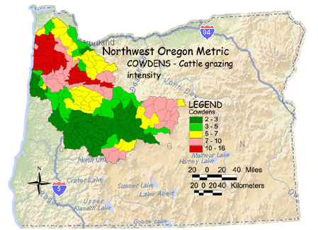
 COWDENS
Cow Grazing Intensity COWDENS
Cow Grazing Intensity 
POPDENS
Population Density
|
 Larger
Image Larger
Image
COWDENS - Cattle grazing intensity
Cattle grazing intensity was calculated by using the county polygon coverages
containing ag census data (number of animals) and is apportioned among
different landscape classes, and the portion of the polygons that fall into the
study boundary. High levels of cattle grazing may stress vegetation, allowing
invasion by non-native species. It may also reduce overall vegetation, which
increases water runoff. Cattle may also damage stream banks, increasing
sediment loads in the stream.
|