Methodology and Interpretation
Percent urban
The percentage of urban land cover is calculated by dividing the number of urban land cover cells in
the reporting unit by the total number of land cover cells in the reporting unit minus those cells
classified as water (i.e., total land area). High amounts of urban land indicate substantial
modification of natural vegetation cover and may have profound effects on wildlife habitat, soil erosion,
and water quality.
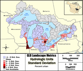

Standard Deviation: Classes show the amount a feature's attribute value varies from the mean
value of the distribution. Class breaks are generated by successively adding or subtracting the
standard deviation from the mean. A two-color ramp is best used to emphasize values above or below the
mean. It is particularly useful in viewing spatial variability of a parameter.
Metric input GIS data:
- United States Hydrologic Units (8-digit HUCs) - Metadata
- United States Coastal Change Analysis Program (CCAP) - Metadata
- Canada Hydrologic Units (Subsubdivisions) - Metadata
- Ontario Ministry of Natural Resources Data Set - Metadata
|