Methodology and Interpretation
Land cover diversity (Shannon-Weiner index)
The diversity index is calculated by:
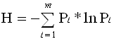 , Pi = the proportion of land cover type i. , Pi = the proportion of land cover type i.
The Shannon-Weiner index is one of several ways to measure the diversity of land cover types
within a specific area of the landscape. The Shannon-Wiener index is a measure of the diversity
of land cover types within a reporting unit, and the index value increases as the number of land
cover types within the reporting unit increases. A single land cover type results in a Shannon-Weiner
index value of zero.
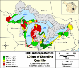
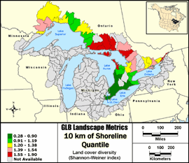
Quantile: Each class contains an approximately equal number (count) of features. A quantile
classification is well-suited to linearly distributed data. Because features are grouped by the number
within each class, the resulting map can be misleading, in that similar features can be separated into
adjacent classes, or features with widely different values can be lumped into the same class. This
distortion can be minimized by increasing the number of classes.
Metric input GIS data:
- United States Hydrologic Units (8-digit HUCs) - Metadata
- United States Coastal Change Analysis Program (CCAP) - Metadata
- Canada Hydrologic Units (Subsubdivisions) - Metadata
- Ontario Ministry of Natural Resources Data Set - Metadata
|