Methodology and Interpretation
Mean distance to closest like-type forest
The mean minimum distance to closest forest patch is the average distance from each forest patch to its
nearest neighboring forest patch in the reporting unit. Distances are measured from edge to edge and are
reported in meters. This metric is useful in determining relative upland forest habitat suitability, at
scales that are ecologically meaningful for specific plant and animal taxa.

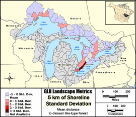
Standard Deviation: Classes show the amount a feature's attribute value varies from the mean
value of the distribution. Class breaks are generated by successively adding or subtracting the
standard deviation from the mean. A two-color ramp is best used to emphasize values above or below the
mean. It is particularly useful in viewing spatial variability of a parameter.
Metric input GIS data:
- United States Hydrologic Units (8-digit HUCs) - Metadata
- United States Coastal Change Analysis Program (CCAP) - Metadata
- Canada Hydrologic Units (Subsubdivisions) - Metadata
- Ontario Ministry of Natural Resources Data Set - Metadata
|