Methodology and Interpretation
Mean distance to closest like-type forest
The mean minimum distance to closest forest patch is the average distance from each forest patch to its
nearest neighboring forest patch in the reporting unit. Distances are measured from edge to edge and are
reported in meters. This metric is useful in determining relative upland forest habitat suitability, at
scales that are ecologically meaningful for specific plant and animal taxa.
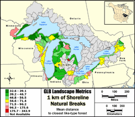
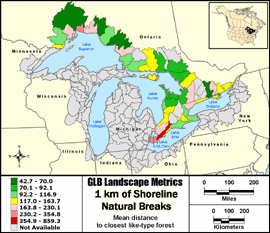
Natural Breaks: Classes are based on natural groupings of data values. Natural break points
are identified by looking for groupings and patterns inherent in the data. The features are divided
into classes whose boundaries are set where there are relatively large jumps in the distribution of
data values.
Metric input GIS data:
- United States Hydrologic Units (8-digit HUCs) - Metadata
- United States Coastal Change Analysis Program (CCAP) - Metadata
- Canada Hydrologic Units (Subsubdivisions) - Metadata
- Ontario Ministry of Natural Resources Data Set - Metadata
|