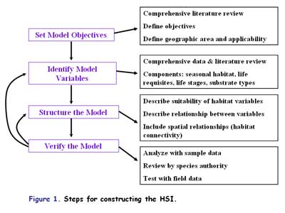
Habitat Suitability Index (HSI)
An HSI is a numerical index that represents the capacity of a given habitat to support a selected species. These models are based on hypothesized species-habitat relationships rather than statements of proven cause and effect relationships. HSI model results represent the interactions of the habitat characteristics and how each habitat relates to a given species. The model can be constructed in a variety of ways, such as a word model, a mechanistic model, a multivariate statistical model, or a combination of these methods. The value is to serve as a basis for improved decision making and increased understanding of species-habitat relationships. Below is a schematic diagram for constructing an HSI (Figure 1).
The HSI describes the suitability of a given habitat by combining the interactions of all key environmental variables on a species’ vital rates and ultimately, survival. Below are some examples of hypothetical plots for a given species where the curves describe suitability of habitat variables for that species’ existence (Figure 2).
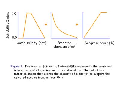
Along the x-axis of each graph in Figure 2 is a habitat variable, which can be considered a stressor, and along the y-axis is a suitability score with 1 being optimum habitat and 0 being least suitable habitat. For example, a species might not do well living in a habitat with a 0 value, but might do really well in an area with a value of 0.8. And the HSI combines these individual scores into one index that predicts the ability of a habitat to support a species. Basically, the HSI is measuring the carrying capacity or the population size that can be supported by the available resources of the habitat. These models are generally developed at the scale of a habitat patch, but there are ways to link habitat patches should you desire to model a larger spatial scale. Habitat maps can be made from HSI values of habitat patches for bay scallops. Aerial photography, underwater video, or other methods can be used to determine the habitat type in an area and the suitability indices can be used to infer potential species distributions or relative abundances. This spatial modeling can be used to define habitats that are most important for a species.