Decision-Support Systems
Introduction
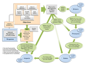
EPA scientists are currently involved in decision-support research with the goals of increasing our national capacity to assess and manage complex environmental problems and advancing methods for integrated assessment. The process of environmental decision making requires use of good science, transparency, stakeholder participation, and learning. Environmental decision support requires the application of appropriate environmental databases, mapping tools, models, and economic valuation methods. EPA decision-support research will seek to provide a framework that enables understanding of the role of different participants in the decision problem, as well as the need for an adaptive assessment that responds to their decision support needs. Scientists will provide innovative, online decision support that offers EPA, regions, states, communities, and resource managers the ability to integrate programs and information, visualize outcomes of the decisions, and maximize use of diverse data, models, and tools at multiple scales to generate alternative decision options and to understand the consequences of management decisions on the sustainability of ecosystem services, their value, and human well being. References and ProductsMeta-Analysis of Phosphorous Attenuation in Best Management Practices (BMP) and Low Impact Development (LID) Practices in Urban and Agricultural Areas (PDF) (32 pp, 621 K) (EPA/600/R-13/208) September 2013 US EPA. (2009) "Ecosystem Services Decision Support: A Living Database of Existing Tools, Approaches, and Techniques for Supporting Decisions Related to Ecosystem Services – Science Brief." Publication No. EPA/600/R-09/102. Eggleton, M.A., R. Ramirez, C.W. Hargrave, K.B. Gido, J.R. Masoner, G.D. Schnell, and W.J. Matthews. (2005). “Predictability of Littoral-Zone Fish Communities Through Ontogeny in Lake Texoma, Oklahoma-Texas, USA.” Environmental Biology of Fishes, 7: 21–36. Masoner, J.R., D.S. Burden, and G.W. Sewell. (2002). “Digital Atlas of Lake Texoma.” U.S. Geological Survey Open-File Report 2002-428. Masoner, J.R., D.S. Burden, and T.E. Short. (2002). “Digital Geologic Map of Sherman Quadrangle, North Central Texas.” U.S. Geological Survey Open-File Report 02-264. ContactDave Burden Tim Canfield Bart Faulkner You will need Adobe Reader to view some of the files on this page. |