Elliot Ditch/Wea Creek Ecological Risk Assessment
>Site Description/History
Environmental Setting
In this section, the history of the site, along with endangered species known (or suspected) to be at the site, is described. Information about the historical and current land-use, as well as types of habitats, and known or suspected sources of contamination.
Site Description
This site is located in Lafayette, Indiana. Elliot Ditch/Wea Creek runs through several urban and rural residential areas, with some residential properties lying within the floodplain of Elliot Ditch/Wea Creek. The presence of elevated levels of polychlorinated biphenyls (PCBs) in fish tissues has initiated a Fish Advisory for this waterway.
Figure 1. Location Map of Elliot Ditch/Wea Creek, Lafayette,
Indiana
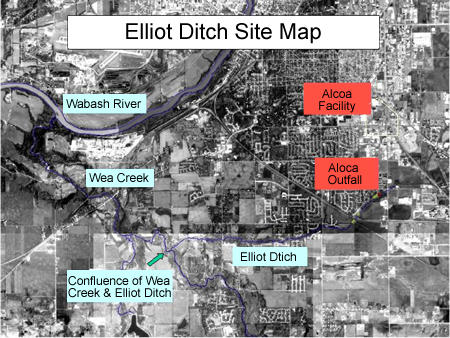
PCBs may have entered the streams from nearby industries, including ALCOA, Inc. ALCOA has undertaken actions to alleviate the PCB contamination, in soils, catch basins, equipment, and sediments. However, there may be other sources of contamination, including outfalls from other facilities.
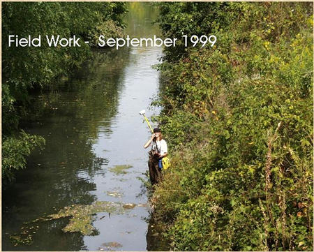
U. S. EPA and Indiana Department of Environmental Management (IDEM) personnel conducted a site inspection on November 17 to 19, 1999. The inspection included the collection of twenty soil samples, seven surface water/outfall samples, and seventy-nine sediment samples. The sample location maps, descriptions of most of the sampling locations, analytical results, and Quality Assurance/Quality Control (QA/QC) information is presented in the inspection report. This site is only in the first stages of the investigation. To date (May 2002), no decisions concerning further investigations or the need for cleanup actions have been made.
Figure 2. Field Investigation - Worker holding Geographic Positioning System (GPS) Unit
Threatened and Endangered Species
The specific species of plants and animals that are found at Elliot Ditch/Wea Creek were not determined in the current study. However, several endangered species were identified.
| Species Common Name | Scientific Name | Status* | Image |
|---|---|---|---|
| Fanshell | Cyprogenia stegaria | E |  |
| Ring Pink | Obovaria retusa | E |  |
| Rough Pigtoe | Pleurobema plenum | E | n.a. |
| Pyramid Pigtoe | P. pyramidatum | E | n.a. |
| Rabbitsfoot | Quadrula c. cylindrica | E | n.a. |
| Bluebreast Darner | Etheostoma camurum | E | |
|
* Status: E = Endangered |
|||
SLERA (Screening Level Risk Assessment):
Screening Level Problem Formulation
(Step 1)
Screening Level Problem Formulation (Step 1)
For this site, the Region 5 ecologist (David Brauner) performed the Ecological Risk Assessment, including calculation of Hazard Quotients (HQ), deciding on potential assessment endpoints and conceptual site models (See ERA Guidance Step 3 for more information on endpoints and site models).
This section describes the likely sources of contamination, what the contaminants are, and what plants and animals at the site are likely to be affected by those contaminants and in what manner.
Contaminants of Potential Ecological Concern (COPECs)
See Table 2 for all COPECs.
Fate, Transport, and Ecotoxicity
Only those chemicals likely to contribute to the potential ecological risks of the site are discussed in this section. This procedure is followed because the screening level ecological risk assessment (SLERA) is based on a screening comparison of the concentrations of COPECs with benchmark guidelines by media (soil, sediment, or surface water). This numerical comparison results in a Hazard Quotient; if the HQ is greater than one, the potential for ecological risk by that COPEC is present. (See Step 2 of the Guidance for more details.)
The benchmark values are sufficiently conservative so that chemicals detected at concentrations below the guidelines are not expected to exhibit significant ecological effects, even if fully bioavailable. Since fate, transport and toxicity variables do not modify the outcome of the screening (these effects are embedded in the derivation of the particular guidelines), discussions of these processes for the chemicals screened out are unlikely to contribute meaningful information to the SLERA.
Exposure Pathways and Potential Receptors
This section is a description of possible complete exposures pathways: ones in which a chemical can be traced from the source to a receptor that may be affected by the chemical. Because site-specific information is not available on what species are present at the site, these exposure pathways and the associated conceptual site model are a generalized/hypothetical portrayal (see Figures 1 and 2 in ERA Guidance Step 3 for examples of possible Conceptual Site Models).
- Aquatic systems:
- Aquatic plants: uptake from sediment and surface water;
- Benthic organisms: ingestion and incidental contact of sediments; ingestion of and contact with surface water;
- Fish: incidental contact of sediments; bioaccumulation from prey; ingestion of and contact with surface water;
- Piscivorus (fish-eating) birds/mammals: incidental contact of sediments; bioaccumulation from prey; ingestion and contact with surface water.
- Terrestrial systems:
- Plants: uptake from soil;
- Invertebrates: incidental contact and ingestion of soil; bioaccumulation from plants;
- Small rodents: incidental contact of soil; bioaccumulation from plants/prey;
- Top predators: incidental contact of soil; bioaccumulation from prey.
- Potential Receptors:
- Benthic invertebrates
- Earthworms
- Fish
- Piscivorus birds (e.g., Great Blue Heron, Kingfisher)
- Piscivorus mammals (e.g., mink)
- Small mammals (e.g., shrew, prairie vole, meadow vole, deer mouse)
- Passerine (perching/songbirds) birds (e.g., American Robin)
- Aquatic birds (e.g., Mallard Ducks)
- Aquatic macrophytes
- Terrestrial plants
-
Wildlife Exposure:
Additional comparisons were made against established Wildlife Exposure Factors. The maximum concentration for each COPEC was compared against exposure screening levels for various groups of organisms or specific species:- aquatic plants,
- daphnids (water fleas),
- minnows,
- rainbow trout,
- benthic (bottom-dwelling) invertebrates,
- terrestrial plants,
- earthworms.
This section includes calculations of Hazard Quotients and calculated estimations of risk by COPECs to potential receptors in different media (soil, sediment, surface water). This step involves the comparison of the concentrations of COPECs with benchmark guidelines by media (sediment, soil, surface water). If the maximum concentration of a chemical found at the site exceeds the screening benchmark guideline, then there is the potential for risk and further study is needed to clarify that risk. (See SLERA Step 2 for more information on the screening process, including calculating Hazard Quotients.)
Ecotoxicological Benchmark Values
The Screening Level Ecological Risk Assessment (SLERA) is based on a screening comparison of the concentrations of COPECs with benchmark guidelines by media.
There is a summary of the screening results (Hazard Quotient (HQ) calculations) in the following tables. Results of analysis of samples of soil, surface water, and sediment taken in the initial site investigation determined the concentrations for a wide number of COPECs. The maximum concentration of each COPEC was then compared to generic screening levels (see Step 2 of the guidance) and toxicity values for a variety of different groups of plants or animals or specific species. This is the Hazard Quotient for each COPEC: the ratio of maximum exposure of a chemical contaminant to the concentration in the medium (e.g., sediments, soil, water) that produces an effect. If the HQ is greater than one, further investigation into the effects of that chemical is needed (i.e., the Baseline Ecological Risk Assessment), because the chemical may cause harm to a particular species or group of plants or animals. If the HQ is less than one, no further study of the effects of that chemical at the site is needed, as harmful effects are not likely.
Where possible, a single benchmark was used for calculating Hazard Quotients in each medium (sediment, soil, or water) or for ecological receptor. The ARCS NEC benchmarks were chosen preferentially over the Region 4 benchmarks because the former uses no-effects concentrations for the sensitive species Hyalella azteca and Chironomus riparius. If the ARCS NEC benchmarks were not available for a particular contaminant, then U.S.EPA Region 4's benchmarks were chosen over other sources. Region 4's benchmarks tended to be highly protective of species and were relatively conservative. If Region 4 benchmarks were not available, benchmarks were chosen according to the following priorities (Link to information on the various screening numbers that were used in this ERA: Screening Numbers):
- Chronic values were used when available.
- More inclusive benchmarks (Canadian Water Quality Guidelines or the Dutch Target levels) over species-specific (LCV Daphnids) or more locally-derived benchmarks (Washington NEL)
- Freshwater over marine
- U. S. EPA Region 5's ESLs were generally chosen only if other benchmarks were not available as they were developed as detection limit numbers, not effect numbers.
Exposure Estimates & Risk Characterization
As can be seen in tables 2a, 2b, and 2c below, (an 'x' indicates that the maximum concentration of the contaminant exceeds the chosen screening number), many COPECs exceed the chosen screening levels, suggesting that there is the potential for serious ecological risk due to chemical contamination of the creek.
If the maximum concentration exceeded a specific screening benchmark, that indicated potential toxic effects (generally mortality) for that particular receptor (daphnid, fathead minnow, rainbow trout, or benthic invertebrate). Note that although the specific species found at Elliot Ditch/Wea Creek (save for the endangered species listed above) are not known, these additional screenings are representative of species that are typically found in habitats such as those found at this site.
Link to Toxicity Profiles for more information on the harmful effects of the various chemicals found at this site.
Table 2a. Pesticides |
|||||||
| Chemical | Surface Water | Soil | Sediments | Daphnids | Fathead Minnows | Rainbow Trout |
Benthic Invertebrates |
|---|---|---|---|---|---|---|---|
| 4,4-DDD |
X
|
||||||
| 4,4-DDE |
X
|
X3
|
|||||
| 4,4-DDT |
X
|
X
|
X
|
X
|
X
|
||
| Aldrin |
X
|
X
|
X
|
X3
|
|||
| b-BHC |
X
|
||||||
| g-BHC (Lindane) |
X
|
X
|
|||||
| a-Chlordane |
1
|
X3
|
X3
|
||||
| g-Chlordane |
1
|
X3
|
X3
|
||||
| Dieldrin |
X
|
X
|
X
|
X
|
X
|
X
|
|
| Endosulfan I |
2
|
X
|
X3
|
||||
| Endosulfan II |
2
|
X
|
X
|
X3
|
|||
| Endosulfan sulfate |
X
|
X
|
X
|
||||
| Endrin |
X
|
X
|
X
|
X
|
X
|
X
|
|
| Endrin aldehyde |
X
|
||||||
| Endrin ketone |
X3
|
X3
|
X
|
||||
| Heptachlor |
X
|
X
|
X
|
X
|
|||
| Heptachlor epoxide |
X
|
X
|
|||||
| PCB Aroclor-1248 |
X4
|
X3
|
X
|
X4
|
X
|
||
|
X - Maximum concentration exceeds screening
benchmark. |
|||||||
Table 2b. Inorganics |
||||||||||
| Chemical | Surface Water | Soil | Sediments | Aquatic Plants | Daphnids | Fathead Minnows | Rainbow Trout | Benthic Invertebrates | Terrestrial Plants | Earthworms |
|---|---|---|---|---|---|---|---|---|---|---|
| Aluminum (Al) |
X
|
X
|
X
|
X3
|
||||||
| Antimony (Sb) |
X
|
X3
|
||||||||
| Arsenic (As) |
X
|
|||||||||
| Barium (Ba) |
X
|
X3
|
X
|
X
|
X3
|
|||||
| Beryllium (Be) |
X 3
|
X 3
|
X
|
X 3
|
||||||
| Cadmium (Cd) |
X
|
X
|
X
|
X
|
X
|
|||||
| Calcium (Ca) |
X1
|
X 1
|
X 1
|
X
|
X 1
|
X
|
X 1
|
X 1
|
||
| Chromium (Cr) |
X
|
X
|
X
|
|||||||
| Cobalt (Co) |
X 3
|
X 3
|
||||||||
| Copper (Cu) |
X
|
X
|
X
|
X
|
X
|
X
|
X
|
|||
| Iron (Fe) |
X
|
X
|
X
|
X 3
|
X
|
X
|
X 3
|
X 3
|
X 3
|
|
| Lead (Pb) |
X
|
X
|
X
|
X
|
X
|
|||||
| Magnesium (Mg) |
X 1
|
X 1
|
X 1
|
X 1
|
X 1
|
X 1
|
X
|
X 1
|
||
| Manganese (Mn) |
X
|
X
|
X 3
|
X
|
X
|
X 3
|
||||
| Mercury (Hg) |
X 2
|
X
|
X 3
|
X
|
||||||
| Nickel (Ni) |
X
|
X
|
X
|
X
|
||||||
| Potassium (K) |
X 1
|
X 1
|
X 1
|
X 1
|
X 1
|
X 1
|
X 1
|
X 1
|
||
| Selenium (Se) |
X
|
X
|
X
|
|||||||
| Silver (Ag) |
X
|
X
|
X
|
X
|
X
|
X
|
X3
|
|||
| Sodium (Na) |
X
|
X 1
|
X 1
|
X 1
|
X 1
|
X 1
|
X 1
|
X 1
|
||
| Thallium (Tl) |
X 3
|
X 3
|
X 3
|
|||||||
| Vanadium (V) |
X
|
X 3
|
X
|
X 3
|
||||||
| Zinc (Zn) |
X
|
X
|
X
|
X
|
X
|
X
|
X
|
X
|
X
|
|
|
X - Maximum concentration exceeds screening
benchmark. |
||||||||||
Table 2c. Other Organics |
|||||||
| Chemical | Surface Water | Soil | Sediments | Daphnids | Fathead Minnows | Rainbow Trout | Benthic Invertebrates |
|---|---|---|---|---|---|---|---|
| 2-Chlorophenol |
X
|
X
|
X 1
|
X 1
|
|||
| 3-Methyl-4-chlorophenol |
X
|
X
|
X 1
|
||||
| 2-Methylnaphthalene |
X
|
X
|
|||||
| 4-Nitrophenol |
X
|
X
|
X
|
||||
| 2,4-Dinitrotoluene |
X
|
X 1
|
X 1
|
X
|
|||
| Acenaphthene |
X
|
X
|
X
|
||||
| Anthracene |
X
|
X
|
X
|
X
|
X
|
||
| Benzaldehyde |
X
|
X 1
|
|||||
| Benz(a)anthracene |
X
|
X
|
X
|
X
|
X
|
||
| Benzo(a)pyrene |
X
|
X
|
X
|
X
|
|||
| Benzo(b)fluoranthene |
X
|
X
|
|||||
| Benzo(g,h,i)perylene |
X
|
X
|
X 1
|
||||
| Benzo(k)fluoranthene |
X
|
X
|
X
|
||||
| Bis(2-ethylhexyl)phthalate |
X
|
X
|
X
|
||||
| Butylbenzylphthalate |
X
|
||||||
| Carbazole |
X 1
|
X 1
|
X 1
|
||||
| Chrysene |
X
|
X
|
X
|
X
|
|||
| Dibenzofuran |
X
|
X 1
|
X
|
||||
| Dibenz(a,h)anthracene |
X
|
X
|
X 1
|
X 1
|
X
|
||
| Dibutylphthalate |
X
|
||||||
| Di-n-octylbutylphthalate |
X 1
|
||||||
| Fluoranthene |
X
|
X
|
X
|
||||
| Fluorene |
X
|
X
|
X
|
||||
| Indeno(1,2,3-cd)pyrene |
X
|
X
|
|||||
| Naphthalene |
X
|
||||||
| N-Nitrosodiphenylamine |
X
|
X
|
|||||
| Pentachlorophenol |
X
|
X
|
|||||
| Phenanthrene |
X
|
X
|
X
|
||||
| Phenol |
X
|
X
|
X
|
||||
| Pyrene |
X
|
X
|
X
|
X
|
X
|
X 1
|
|
|
X - Maximum concentration exceeds screening
benchmark. |
|||||||
The Elliot Ditch/Wea Creek site is currently at this stage in the assessment process.
Conclusions and Recommendations:
Based on the information presented in this assessment, the conditions at the Elliot Ditch/Wea Creek site may pose risk to benthic invertebrates, terrestrial invertebrates, and aquatic invertebrates, as well as possibly to organisms in higher trophic levels. Additional evaluation may be needed to further refine the potential risk to ecological receptors. It is recommended that further studies should include the following:
- An evaluation of the presence of threatened or endangered species in the areas potentially effected by the site;
- An evaluation of the actual existence of suggested exposure pathways, which should include a more detailed habitat/vegetation survey and surveys of benthic (bottom-dwelling), aquatic, and terrestrial organisms (both vertebrates and invertebrates);
- A chemical analysis of benthic, aquatic, and terrestrial invertebrates;
- Additional analytical tests including site-specific toxicity testing, especially for invertebrates and fishes, to help determine levels and extent of bioaccumulation in the various ecosystems/habitats found at the site;
- Tissue residue analyses for potential ecological receptors.
It has not been yet decided if further actions will be necessary or what they will be.
-
July 2001 - Screening Level Ecological Risk Assessment completed.
Links to more information on this site
Contacts for this site
- David Brauner, Ecologist, U.S. EPA Region 5 (brauner.david@epa.gov)
- Jan Pels, U.S. EPA Region 5 (pels.jan@epa.gov)
You will need Adobe Reader to view some of the files on this page. See EPA's PDF page to learn more.